
The M60 motorway, Manchester Ring Motorway or Manchester Outer Ring Road is an orbital motorway in North West England. Built over a 40-year period, it passes through most of Greater Manchester's metropolitan boroughs except for Wigan and Bolton. Most of Manchester is encompassed within the motorway, except for the southernmost part of the city which is served by the M56.

The M62 is a 107-mile-long (172 km) west–east trans-Pennine motorway in Northern England, connecting Liverpool and Hull via Manchester, Bradford, Leeds and Wakefield; 7 miles (11 km) of the route is shared with the M60 orbital motorway around Manchester. The road is part of the unsigned Euroroutes E20 and E22.

The A6 is one of the main north–south roads in England. It runs from Luton in Bedfordshire to Carlisle in Cumbria, although it formerly started at a junction with the A1 at Barnet. It is the fourth longest numbered road in Britain; only the A1, A38 and A30 are longer.

The M56 motorway, serves the Cheshire and Greater Manchester areas of England. It runs east to west from junction 4 of the M60 at Gatley, south of Manchester, to Dunkirk, approximately four miles north of Chester. With a length of 33.3 miles (53.6 km), it connects North Wales and the Wirral peninsula with much of the rest of North West England, serves business and commuter traffic heading towards Manchester, particularly that from the wider Cheshire area, and provides the main road access to Manchester Airport from the national motorway network.

The M53 is an 18.9-mile (30.4 km) motorway in the Metropolitan Borough of Wirral and Cheshire on the Wirral Peninsula in England. It is also referred to as the Mid Wirral Motorway. It runs between the Kingsway Tunnel, at Wallasey in the north, and the A55 at Chester.

The M65 is a motorway between Preston and Colne in Lancashire, England. It runs from Bamber Bridge just south of Preston, through major junctions with the M6 and M61 motorways, east past Darwen, Blackburn, Accrington, Burnley, Brierfield, Nelson and ends at Colne.

The M58 is a motorway passing through Merseyside and Lancashire, terminating in Greater Manchester. It is 12 miles (19.3 km) long and provides a link between the M6 motorway and the Metropolitan Borough of Sefton and hence on, via the A5036, to the Mersey docks in Liverpool and Birkenhead.
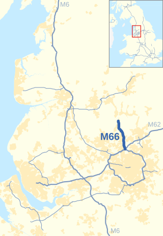
The M66, also known as the Bury Easterly Bypass, is a motorway in Lancashire and Greater Manchester, England. It is 8 miles (13 km) long and provides part of the route between the M62 and M60 motorways and the M65, with the rest being provided by the A56.
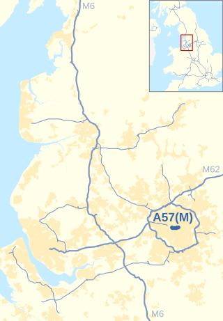
The Mancunian Way is a two mile long grade separated elevated motorway in Manchester, England. It is officially made up of the A57(M) and A635(M) motorways, although the latter does not appear on road signs for practical reasons. It is also part of two other roads: the A57 to the west, which runs east–west through Greater Manchester linking the M602 and M67 motorways, and a short section of non-motorway A635 to the east. Part of this non-motorway section collapsed on 14 August 2015 due to a sinkhole.

The Calder Valley line is a railway route in Northern England between the cities of Leeds and Manchester as well as the seaside resort of Blackpool. It is the slower of the two main rail routes between Leeds and Manchester, and the northernmost of the three main trans-Pennine routes.
Edenfield is a village within the Rossendale borough of Lancashire, England. Lying on the River Irwell, it is around 1.25 miles (2.0 km) north of Ramsbottom, 2.5 miles (4.0 km) south of Rawtenstall, and 6.0 miles (9.7 km) west of Norden, and has a total population of 2,080, reducing to 2,053 at the 2011 Census.
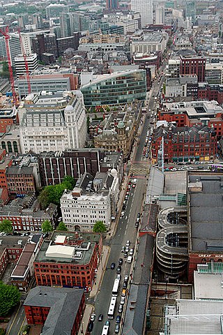
Deansgate is a main road through Manchester City Centre, England. It runs roughly north–south in a near straight route through the western part of the city centre and is the longest road in the city centre at over one mile in length.

The A54 road is a road in England linking Chester in Cheshire with Buxton in Derbyshire. Its route through both urban and steep rural areas presents a challenge to Cheshire County Council in maintaining the safety of the road. Many years ago it was the main east–west route in Cheshire. The importance of the A54 through Middlewich and Winsford decreased in the 1970s and 1980s with the building of the M56 motorway and dualling of the A556 at Northwich. The section through Winsford carries approximately 30,000 vehicles per day.

The A627(M) is a motorway that runs between Chadderton and Rochdale in Greater Manchester, England. It is 3.5 miles (5.6 km) long and connects the two towns to the M62. It opened in 1972.
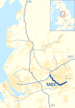
The M63 motorway was a major road in the United Kingdom. It was completely renumbered, in 1998, to become a substantial part of the M60 motorway which orbits part of Greater Manchester.

The A556 is a road in England which extends from the village of Delamere in Cheshire West and Chester to the Bowdon Interchange in Cheshire East, bordering Greater Manchester. The road contains a mixture of single and dual carriageway sections and forms a large part of the route between Manchester and Chester. It also acts as a major access route to Chester/North Wales to the west and to Manchester to the east for the conurbation of towns and villages around the Dane Valley centering on Winsford and Northwich. The central part, which forms the Northwich Bypass between Davenham and Lostock Gralam, suffers because of the amount of commuter traffic from this area. The part of the route between the M6 motorway Junction 19 and the M56 motorway Junction 7 is a major route into Manchester and has been recently upgraded to a four-lane dual carriageway.

The A5103 is a major road in England. It runs from Piccadilly Gardens in Manchester city centre to junction 3 of the M56 motorway and is one of Manchester's principal radial routes.

The A671 is a road in the North West of England, that runs between Oldham, Greater Manchester and Worston, near Clitheroe, Lancashire. Major towns on the route include Rochdale and Burnley. The road is approximately 35 miles (56 km) long. Between Burnley and the A59, the A671 has primary status.

The Chester–Warrington line is a railway line running between Chester and Warrington Bank Quay in North West England.

Cheetham Hill Road is a road in north Manchester, England, running from Corporation Street in Manchester city centre to Prestwich. In Crumpsall, its name changes to Bury Old Road.

