
The M25 or London Orbital Motorway is a major road encircling most of Greater London. The 117-mile (188-kilometre) motorway is one of the most important roads in the UK and one of the busiest. Margaret Thatcher opened the final section in 1986, making the M25 the longest ring road in Europe upon opening. The Dartford Crossing completes the orbital route but is not classed as motorway; it is classed as a trunk road and designated as the A282. In some cases, including notable legal contexts such as the Communications Act 2003, the M25 is used as a de facto alternative boundary for Greater London.

The M11 is a 55 miles (89 km) motorway that runs north from the North Circular Road (A406) in South Woodford to the A14, northwest of Cambridge, England. Originally proposed as a trunk road as early as 1915, various plans were considered throughout the 1960s, with final construction being undertaken between 1975 and 1980. The motorway was opened in stages, with the first stage between junctions 7 and 8 opening in June 1975, and the completed motorway becoming fully operational in February 1980. Running from Woodford to Girton, the motorway provides direct access to Harlow, Cambridge and since 2002, greatly improved access to London Stansted Airport.

The M1 motorway connects London to Leeds, where it joins the A1(M) near Aberford, to connect to Newcastle. It was the first inter-urban motorway to be completed in the UK; the first motorway in the country was the Preston Bypass, which later became part of the M6.

The M40 motorway links London, Oxford, and Birmingham in England, a distance of approximately 89 miles (143 km).

The Blackwall Tunnel is a pair of road tunnels underneath the River Thames in east London, England, linking the London Borough of Tower Hamlets with the Royal Borough of Greenwich, and part of the A102 road. The northern portal lies just south of the East India Dock Road (A13) in Blackwall; the southern entrances are just south of The O2 on the Greenwich Peninsula. The road is managed by Transport for London (TfL).
The A2 is a major road in south-east England, connecting London with the English Channel port of Dover in Kent. This route has always been of importance as a connection between London and sea trade routes to Continental Europe. It was originally known as the Dover Road. The M2 motorway has replaced part of the A2 as the strategic route.

The M23 is a motorway in the United Kingdom, running from the south of Hooley in Surrey, where it splits from the A23, to Pease Pottage, south of Crawley in West Sussex where it rejoins the A23. The northern end of the motorway starts on what is effectively a 2-mile (3.2 km) spur north of junction 7 of the M25 motorway. From Hooley it runs for 17 miles (27 km) past Redhill, Gatwick Airport and Crawley. A spur runs from junction 9 to Gatwick Airport.

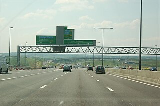
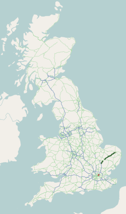
The A12 is a major road in Eastern England. It runs north-east/south-west between London and the coastal town of Lowestoft in the north-eastern corner of Suffolk, following a similar route to the Great Eastern Main Line until Ipswich. A section of the road between Lowestoft and Great Yarmouth became part of the A47 in 2017. Between the junctions with the M25 and the A14, the A12 forms part of the unsigned Euroroute E30. Unlike most A roads, this section of the A12, together with the A14 and the A55, has junction numbers as if it were a motorway.
The A11 is a major trunk road in England. It originally ran roughly north east from London to Norwich, Norfolk. It now consists of a short section in Inner London and a much longer section in Cambridgeshire, Suffolk and Norfolk. The lengthy section between these was renumbered as a result of the opening of the M11 in the 1970s and then the A12 extension in 1999.
The A13 is a major road in England linking Central London with east London and south Essex. Its route is similar to that of the London, Tilbury and Southend line via Rainham, Grays, Tilbury, Stanford-Le-Hope & Pitsea,and runs the entire length of the northern Thames Gateway area, terminating on the Thames Estuary at Shoeburyness. It is a trunk road between London and the Tilbury junction, a primary route between there and Sadlers Hall Farm near South Benfleet, and a non-primary route between there and Shoeburyness.

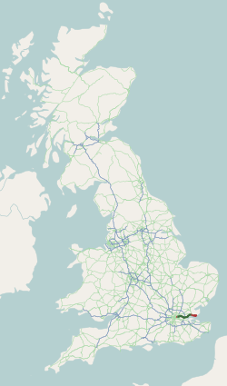
The Eastern Avenue is one of the main roads leading out of London. The 10-mile (16 km) road is part of the A12, a 129-mile road connecting Blackwall in London with the seaside town of Lowestoft in Suffolk.

The M15 motorway was the designation planned in the late 1960s and early 1970s for use on the North Circular Road (A406) after it had been upgraded to motorway standard. The upgrade was part of the London Ringways Plan to build motorways throughout London to ease congestion in the central area. Under the Ringways Plan, the North Circular Road was the northern section of Ringway 2.

The West Cross Route (WCR) is a 0.75 mile segment of dual carriageway of the A3220 route in West London running north–south between the northern elevated roundabout junction with the western end of Westway (A40) and the southern Holland Park Roundabout. It runs through Shepherd's Bush to its west and Notting Hill to its east.

East Cross Route (ECR) is a dual-carriageway road constructed in east London as part of the uncompleted Ringway 1 as part of the London Ringways plan drawn up the 1960s to create a series of high speed roads circling and radiating out from central London. The road was constructed between 1967 and 1973 and runs from Hackney Wick in north-east London, through the Blackwall Tunnel, to Kidbrooke in south-east London. The ECR was initially designated as part of the A102, but has, subsequently, been partially renumbered so that sections of it are now the A2 and A12.

The London Ringways were a series of four ring roads planned in the 1960s to circle London at various distances from the city centre. They were part of a comprehensive scheme developed by the Greater London Council (GLC) to alleviate traffic congestion on the city's road system by providing high speed motorway-standard roads within the capital, linking a series of radial roads taking traffic into and out of the city.
North Cross Route (NCR) was a planned motorway-standard road which would have formed the northern section of Ringway 1 and would have formed the innermost circuit of the London Ringways network. The six-lane dual carriageway with grade separated junctions to an extended M1 motorway was planned during the late 1960s along with the rest of the Ringway scheme. It was never constructed due to large-scale opposition from many quarters.

The M12 motorway was a planned motorway starting in north-east London and joining the A12 road in Essex. The 1960s scheme would have started at a junction with the M11 motorway and North Circular and ended near Brentwood, Chelmsford, or at the proposed new Maplin Sands airport; the motorway was part of the ambitious London Ringways plan to build motorways throughout London. Although most of the Ringways plan was cancelled in 1969 the M12 motorway project was still included in the Roads for Prosperity white paper published in 1989 along with major proposed developments to the A12 road. It was not formally cancelled until 30 March 1994 by the Secretary of State for Transport, John MacGregor.
The A3220 is a primary A road in London, England. It runs north from Clapham Common to the A40 Westway at Ladbroke Grove.

The M16 motorway was the designation planned in the late 1960s and early 1970s for use on Ringway 3, a new motorway planned as part of the London Ringways Plan to run a circular route around London.

