A1058 road

Last updated

UK road A1058.svg
A1058
W.D. and H.O. Wills Building - geograph.org.uk - 17043.jpg
W. D. and H. O. Wills Building on A1058
Route information
Length7.4 mi (11.9 km)
Major junctions
West end Jesmond
54°58′58″N1°36′16″W / 54.9828°N 1.6044°W / 54.9828; -1.6044 (A1058 road (western end))
Major intersectionsUK-Motorway-A167 (M).svg A167(M)
UK road A188.svg A188
UK road A186.svg A186
UK road A19.svg A19
UK road A1108.svg A1108
UK road A192.svg A192
UK road A193.svg A193
East end Tynemouth
55°01′30″N1°26′07″W / 55.0251°N 1.4354°W / 55.0251; -1.4354 (A1058 road (eastern end))
Location
Country United Kingdom
Road network

The A1058, known locally as the Coast Road, [1] [2] is a major road in Newcastle upon Tyne and the adjoining borough of North Tyneside in the North East. It runs from the Newcastle Central Motorway to the coast, terminating between Whitley Bay and Tynemouth. From west to east it connects Newcastle city centre with Jesmond, Heaton, Wallsend, Battle Hill, Howdon, Meadow Well, North Shields, Whitley Bay and Tynemouth. The road has existed since December 1924, when it was opened by then-transport minister Wilfrid Ashley. [3]

Contents

For five miles (8 kilometres) of its eight-mile (12.5 kilometre) route it is a full urban dual carriageway with grade separated interchanges and, for four of those miles, was 70-mile per hour national speed limit Now reduced to 50 miles per hour as of October 2023. However, it is not built to full UK standards for motorway-style roads, as it has too many entrances and exits and most of its sliproads have pedestrian crossings.

Route

The road starts at the Jesmond Road Interchange, with the B1600 and A167(M).The A1058 originally started on the A1 Barras Bridge and headed east along Jesmond Road. With the construction of the A167(M) Central Motorway, the road was cut back. The road heads eastwards. This first section was originally A188 but soon afterwards the new-build begins, marked by the upgrade to dual carriageway. The road remains dual-carriageway and grade-separated for some miles now.

After being a grade-separated dual-carriageway for 4.8 miles (7.7 km) the A1058 comes to a complete stop at a set of traffic lights with the A1108 and B1316. It then continues as Beach Road for 0.8 miles (1.3 km) until it comes to a halt at the roundabout junction with the A192. Originally, it continued east of here along Queen Alexandra Road and so on, finally along King Edward Road to end on the A193 near the station, one block from the sea front. This section is now unclassified and a bypass has been built taking the A1058 to the north of Tynemouth Golf Course, where it still ends a block away from the North Sea coast on the A193.

Interchanges

The A1058 interchanges with two other major roads, the A19 and the A167. The interchange with the A167 on the Newcastle Central Motorway was constructed along with the motorway itself finishing in 1973, and has remained largely unchanged in the fifty years since. [4]

The Coast Road has crossed the A19 at what is now called Silverlink Interchange since 1967, when the first Tyne Tunnel finished construction. [5] However, Silverlink Retail Park itself has only existed since c. 1990; it is accessible directly from the interchange's roundabout, along with Cobalt Business Park, a significant economic organ of the area. Prior to 2016 there was no direct through route on the A19; traffic on that road had to use the roundabout with traffic to and from the A1058 and the retail park, which caused the interchange to be congested and dangerous. Beginning in 2016 and completing construction in April 2019, National Highways constructed the first three-level stack interchange in the North East, meaning both roads now have a free flowing through route. [6] [2]

History

The original Coast Road The 4.7 mile road between Chillingham Road, Newcastle upon Tyne to Billy Mill, Queen Alexander Road West, Tynemouth was opened by Col. Wilfrid Ashley, Minister of Transport, on 27 October 1927. The width was 100 feet with a 30 foot reinforced concrete carriageway on the north side and 7 foot footpaths separated from the carriageway by 5.5 foot verges. There was space allowed for future dualling.

Four local authorities were involved in the construction of the road as well as the Ministry of Transport which contributed 50% of the £180,000 cost. The local authorities contributed the remaining £90,000 balance in the following proportions:- Newcastle Corporation 44.7%, Tynemouth Corporation 34.1%, Wallsend Corporation and Longbenton Urban District Council 1.2%.

Whitley and Monkseaton Urban District Council and Earsdon Urban District Council were party to the initial negotiations as it was then proposed to make a new branch road from Billy Mill, via Rake House Lane through the Earsdon District direct to Whitley Bay. However Whitley Bay withdrew which thus involved the withdrawal of Earsdon Council and the branch road was deleted from the scheme.

The road saved 2.5 miles (4.0 km) from the old route through Longbenton.

In his opening speech Lord Ashley, with it being a fine day, said that it seemed a land of perpetual sunshine and might be termed the Northern Riviera. He congratulated them on the completion of the great enterprise and enabling the citizens of Newcastle to have easier access to the charming seaside resort of Tynemouth at the end of the road. It would also help commercial enterprise.

Later upgrades

The 0.6 mile Cradlewell Bypass at Jesmond, from Sandyford Road to Benton Bank, was due to open in January 1996. It included a 110 metre underpass and a 4 span viaduct over Ouse Burn adjacent to the existing Benton Bank Bridge. Cost was £15 million.

Related Research Articles

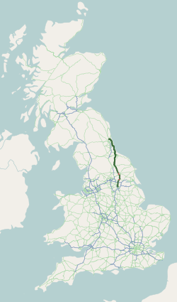
The A1, also known as the Great North Road, is the longest numbered road in the United Kingdom, at 410 miles (660 km). It connects London, the capital of England, with Edinburgh, the capital of Scotland. The numbering system for A-roads, devised in the early 1920s, was based around patterns of roads radiating from two hubs at London and Edinburgh. The first number in the system, A1, was given to the most important part of that system: the road from London to Edinburgh, joining the two central points of the system and linking the UK's (then) two mainland capital cities. It passes through or near north London, Hatfield, Welwyn Garden City, Stevenage, Baldock, Letchworth Garden City, Biggleswade, Eaton Socon, Buckden, Peterborough, Stamford, Grantham, Newark-on-Trent, Retford, Doncaster, Pontefract, York, Wetherby, Ripon, Darlington, Durham, Gateshead, Newcastle upon Tyne, Morpeth, Alnwick and Berwick-upon-Tweed.

<span class="mw-page-title-main">M40 motorway</span> British motorway connecting London and Birmingham

The M40 motorway links London, Oxford, and Birmingham in England, a distance of approximately 89 miles (143 km).

<span class="mw-page-title-main">North Tyneside</span> Metropolitan borough in England

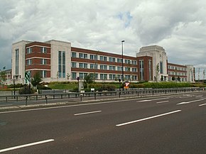
North Tyneside is a metropolitan borough in the metropolitan county of Tyne and Wear, England. It forms part of the greater Tyneside conurbation. North Tyneside Council is headquartered at Cobalt Park, Wallsend.

<span class="mw-page-title-main">A19 road</span> Road in Northern England

The A19 is a major road in England running approximately parallel to and east of the A1 road. Although the two roads meet at the northern end of the A19, the two roads originally met at the southern end of the A19 in Doncaster, but the old route of the A1 was changed to the A638. From Sunderland northwards, the route was formerly the A108. In the past the route was known as the East of Snaith-York-Thirsk-Stockton-on-Tees-Sunderland Trunk Road. Most traffic joins the A19, heading for Teesside, from the A168 at Dishforth Interchange.

<span class="mw-page-title-main">A500 road</span> Road in England

The A500 is a major primary A road in Staffordshire and Cheshire, England. It is dual carriageway for most of its length and connects Nantwich, junctions 16 and 15 of the M6 motorway with the city of Stoke-on-Trent. It is 19 miles (31 km) long.

<span class="mw-page-title-main">A167 road</span> Road in north east England

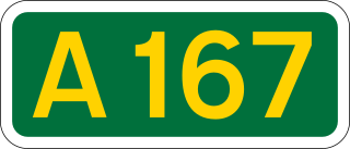
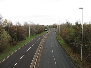
The A167 and A167(M) is a road in North East England. It is partially a trunk road and partially a motorway, where it is commonly referred to as Newcastle Central Motorway. Most of the road’s route was formerly that of the A1, until it was re-routed with the opening of the A1(M) in the 1960s.

<span class="mw-page-title-main">A689 road</span> Road in England

The A689 is a road in northern England that runs east from the A595, 3.1 miles (5.0 km) to the west of Carlisle in Cumbria, to Hartlepool in County Durham.

<span class="mw-page-title-main">A194 road</span> Road in Tyne and Wear, England

The A194 road is a road in Tyne and Wear, England. It runs northeast from its start at junction 65 of the A1(M) near Washington, and the first 3 miles (4.8 km) are motorway standard, designated the A194(M). There are intermediate junctions with the A182 and the A195 before the motorway section ends at the A184 junction. The junctions were unnumbered until 2013 when they were designated J1 to J3.

<span class="mw-page-title-main">A1068 road</span> Road in northern England

The A1068 is a road in northern England that runs from Seaton Burn in North Tyneside to Alnwick in Northumberland. The section between Ellington and Alnmouth is signposted as part of the Northumberland Coastal Route.

<span class="mw-page-title-main">A3220 road</span> Road in west London

The A3220 is a primary A road in London, England. It runs north from Clapham Common to the A40 Westway at Ladbroke Grove.

<span class="mw-page-title-main">Transport in Tyne and Wear</span> Overview of transport in Tyne and Wear

Tyne and Wear is a metropolitan area covering the cities of Newcastle upon Tyne and Sunderland, as well as North and South Tyneside, Gateshead and Washington.

<span class="mw-page-title-main">A186 road (England)</span> Road in Tyne and Wear, England

The A186 is a road in Tyne and Wear, England. It runs between the A1 Junction 75, and the eastern end of the A69 to the A192 in Whitley Bay. It follows the old A69 into Newcastle-upon-Tyne city centre.

<span class="mw-page-title-main">Newcastle Link Road</span> Road in New South Wales, Australia

Newcastle Link Road is a limited-access road in New South Wales linking the interchange of Pacific Motorway and Hunter Expressway at Cameron Park, to Wallsend in western Newcastle. It is designated part of route A15.

The A1 road around Gateshead and Newcastle upon Tyne after arriving from the south as the A1(M) from its origin in London, currently runs from the A1(M) terminus at Birtley. It then swings to the west of both Gateshead and Newcastle via Coal House, Lobley Hill, Metrocentre, Swalwell, Blaydon Bridge, West Denton, Fawdon and Wideopen to Seaton Burn interchange before continuing north towards Edinburgh.

<span class="mw-page-title-main">1973 Tyne and Wear County Council election</span> Election

The 1973 Tyne and Wear County Council election was held on 12 April 1973 as part of the first elections to the new local authorities established by the Local Government Act 1972 in England and Wales. 104 councillors were elected from 95 electoral divisions across the region's five boroughs. Each division returned either one or two county councillors each by First-past-the-post voting for a four-year term of office. The election took place ahead of the elections to the area's metropolitan borough councils, which followed on 10 May 1973.

The county of Northumberland has returned four MPs to the UK Parliament since 1983. Under the Local Government Act 1972, which came into effect on 1 April 1974, the boundaries of the historic/administrative county were significantly altered with the south-east of the county, comprising more than half the electorate, being transferred to the new metropolitan county of Tyne and Wear. These changes were reflected in the following redistribution of parliamentary seats which did not come into effect until the 1983 general election, resulting in a reduction in the county's representation from 10 to 4 MPs.

References

  1. Goodwin, Nicole (24 January 2022). "'RIP Meat Loaf' graffiti appears on Heaton roundabout after rock legend's death". ChronicleLive . Retrieved 11 March 2022.
  2. 1 2 Graham, Hanna (2 April 2019). "The A19 under Silverlink Roundabout is open – but when will Coast Road speed limits end?". ChronicleLive . Retrieved 11 March 2022.
  3. "Two Magnificent Roads". British Pathé . 15 December 1924. Retrieved 11 March 2022.
  4. Southern, Keiran (24 September 2016). "How Newcastle's Central Motorway was made – and the story of two-thirds that were never built". ChronicleLive . Retrieved 11 March 2022.
  5. Fenwick, Paul (2012). "The Tyne Tunnels" (PDF). Chartered Institution of Highways and Transportation . Retrieved 11 March 2022.
  6. "Silverlink roundabout to become 'triple decker' in £75m scheme". ITV News . 29 June 2016. Retrieved 11 March 2022.

55°00′14″N1°31′25″W / 55.0038°N 1.5235°W / 55.0038; -1.5235 (A1058 road)