The East Riding of Yorkshire, often abbreviated to the East Riding or East Yorkshire, is a ceremonial county in the Yorkshire and the Humber region of England. It borders North Yorkshire to the north and west, South Yorkshire to the south-west, and Lincolnshire to the south across the Humber Estuary. The city of Kingston upon Hull is the largest settlement.

The Yorkshire Wolds are hills in the counties of the East Riding of Yorkshire and North Yorkshire in Northern England. They are the northernmost chalk hills in the UK and within lies the northernmost chalk stream in Europe, the Gypsey Race.

Driffield, also known as Great Driffield, is a market town and civil parish in the East Riding of Yorkshire, England. The civil parish is formed by the town of Driffield and the village of Little Driffield. By road, it is 53 miles (85 km) north-east of Leeds, 29 miles (47 km) east of York and 23 miles (37 km) north of Hull.

Wetwang is a Yorkshire Wolds village and civil parish in the East Riding of Yorkshire, England, 6 miles west of Driffield on the A166 road.

Stamford Bridge is a village and civil parish on the River Derwent in the East Riding of Yorkshire, England, approximately 5 miles (8 km) east of York and 22 miles (35 km) west of Driffield. The village sits astride an ancient ford on the River Derwent.

The A614 is a main road in England running through the counties of Nottinghamshire, South Yorkshire and the East Riding of Yorkshire.

Bishop Wilton Wold is the highest point of the Yorkshire Wolds in the East Riding of Yorkshire, England. The summit, known as Garrowby Hill, lies about five miles north of Pocklington.

The A64 is a major road in North and West Yorkshire, England, which links Leeds, York and Scarborough. The A64 starts as the A64(M) ring road motorway in Leeds, then towards York it becomes a high-quality dual carriageway until it is east of the city, where it becomes a single carriageway for most of its route to Scarborough.

Little Driffield is a small village in the civil parish of Driffield, in the East Riding of Yorkshire, England. It is situated on the western outskirts of Great Driffield, to the west of the A614 road and south of the A166 road.

Garton on the Wolds is a village and a civil parish on the Yorkshire Wolds in the East Riding of Yorkshire, England. It is situated approximately 3 miles (5 km) north-west of Driffield town centre and lies on the A166 road.
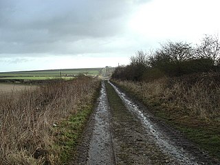
Woldgate is a minor road in the East Riding of Yorkshire, England, which follows the line of a Roman road. It runs for a distance of 10 miles (16 km) from a junction with the A165 on the western edge of Bridlington, through the village of Kilham, to a junction with the B1249 4 miles (6 km) north of Driffield. For most of its length Woldgate follows a low ridge of the Yorkshire Wolds, with extensive views to north and south.

The Malton and Driffield Junction Railway, later known as the Malton and Driffield branch was a railway line in Yorkshire that ran between the towns of Malton, North Yorkshire and Driffield in the East Riding of Yorkshire.
Kirby Underdale is a village and civil parish in the East Riding of Yorkshire, England. It is situated approximately six miles north of Pocklington town centre and lies one mile north of the main A166 road from York to Driffield.
Garrowby is a hamlet in the East Riding of Yorkshire, England. It is situated approximately 5 miles (8 km) north of Pocklington town centre. It lies to the north of the A166 road and forms part of the civil parish of Kirby Underdale.

The York–Beverley line was a railway line between York, Market Weighton and Beverley in Yorkshire, England. The line was sanctioned in 1846 and the first part, the York to Market Weighton Line opened in 1847. Construction of the second part to Beverley was delayed for 17 years in part by the downfall of George Hudson, and a less favourable financial environment following the collapse of the 1840s railway bubble; the North Eastern Railway revived and completed the scheme in the 1860s; the Market Weighton to Beverley Line opened in 1865.
The East Riding of Yorkshire is a local government district with unitary authority status, and is a ceremonial county of England. It is named after the historic East Riding of Yorkshire which was one of three ridings alongside the North Riding and West Riding, which were constituent parts a Yorkshire ceremonial and administrative county until 1974. From 1974 to 1996 the area of the modern East Riding of Yorkshire constituted the northern part of Humberside.
The Minster Way is a 50-mile (80 km) walking route between the Minsters of Beverley and York in England. It crosses the chalk hills of the Yorkshire Wolds, as well as a wide variety of the East Riding of Yorkshire countryside. Part of the route follows the Yorkshire Wolds Way National Trail across Sylvan Dale before diverting to Millington, Bishop Wilton and Stamford Bridge, where it follows the River Derwent into the Plain of York as far as the River Ouse.

The Chalkland Way is a 40-mile (64 km) circular walking route in the East Riding of Yorkshire and North Yorkshire, England. The route covers the chalky hills and valleys of the western Yorkshire Wolds, with the common starting point in the town of Pocklington.

Stamford Bridge is a historic bridge, in the village of Stamford Bridge, in the East Riding of Yorkshire in England.
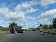 Grimston Bar junction showing A1079 and A166 exits
 Duke of York on the A166 at Gate Helmsley
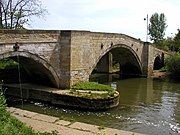 The road bridge at Stamford Bridge over the River Derwent
 Garrowby Hill with Emergency Stopping Track
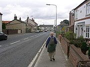 Fridaythorpe on the A166
 Village pond at Wetwang
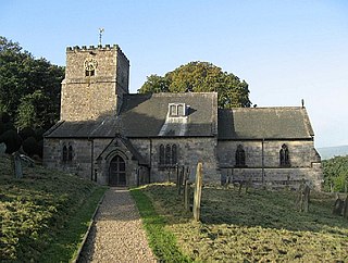
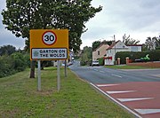 Garton on the Wolds
 Driffield Bypass


