
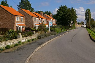
Leconfield is a village and civil parish in the East Riding of Yorkshire, England, about 3 miles (5 km) north-west of Beverley town centre. It lies on the A164 road. The civil parish consists of Leconfield, the village of Arram and the hamlet of Scorborough. The 2011 UK census gave the parish a population of 2,127, an increase on the 2001 UK census figure of 1,990.

Eastrington is a small village and civil parish in the East Riding of Yorkshire, England. It is situated approximately 3 miles (5 km) to the east of Howden and 17 miles (27 km) south east of York.
Wressle is a village and civil parish in the East Riding of Yorkshire, England, lying on the eastern bank of the River Derwent approximately 3 miles (5 km) north-west of Howden.

Aldbrough is a village and civil parish in the East Riding of Yorkshire, England, about 12 miles (19 km) north-east of Hull at the junction of the B1242 and B1238 roads. It lies near to the North Sea coast within the area of Holderness.

Kexby is a village and civil parish in the unitary authority of the City of York in North Yorkshire, England. It lies on the A1079 about 5 miles (8 km) east of York, on the River Derwent and the East Riding of Yorkshire border.

Hotham is a small village and civil parish in the East Riding of Yorkshire, England. It is situated approximately 16 miles (26 km) west of Hull, 21 miles (34 km) south east of York and 4 miles (6 km) south of Market Weighton town centre. The village has road links with the cities of Kingston upon Hull, York and Leeds. The eastern end of the M62 motorway, at Junction 38, is 2 miles (3 km) south-west from Hotham.
Cottam is a hamlet and civil parish in the East Riding of Yorkshire, England. The hamlet is west of the B1249 Skipsea to Staxton road, and in the Yorkshire Wolds. It is 16 miles (30 km) north from the county town of Beverley, and approximately 4 miles (6 km) east from the village of Sledmere.

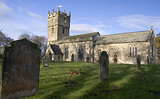
South Dalton is a village in the East Riding of Yorkshire, England. It is situated 1 mile (1.6 km) to the west of the B1248 road, and approximately 6 miles (10 km) north-east from the market town of Market Weighton and 5 miles (8 km) north-west from the market town of Beverley. Etton lies 1.5 miles (2.4 km) to the south-east. North Dalton is approximately 4.5 miles (7 km) north-west, with the villages of Middleton on the Wolds and Lund between.

Wilberfoss is a village and civil parish in the East Riding of Yorkshire, England. It is situated on the north side of the A1079 approximately 8 miles (13 km) east of York city centre and 11 miles (18 km) north-west of Market Weighton. According to the 2011 UK census, Wilberfoss parish had a population of 1,866, an increase on the 2001 UK census figure of 1,855.
Langton is a village and civil parish in the Ryedale district of North Yorkshire, England. Until 1974 the village lay in the historic county boundaries of the East Riding of Yorkshire. It is situated 3.5 miles (6 km) south from the market town of Malton. The population at the 2011 Census was less than 100. Details are included in the civil parish of Birdsall, North Yorkshire.

South Newbald is a hamlet in the East Riding of Yorkshire, England. It is situated approximately 12 miles (19 km) north-west of Hull city centre, 2.5 miles (4 km) north of South Cave and 4 miles (6.4 km) south of Market Weighton. It lies to the east of the A1034 road. The larger village of North Newbald is just to the north.
North Frodingham is a village and civil parish in the East Riding of Yorkshire, England. It is situated approximately 5.5 miles (9 km) south-east of the town of Driffield and lies on the B1249 road.
Laxton is a village and civil parish in the East Riding of Yorkshire, England. The village is situated approximately 2 miles (3 km) east from Howden and 19 miles (31 km) south-east from the county town of York.
Kirby Underdale is a village and civil parish in the East Riding of Yorkshire, England. It is situated approximately 6 miles (10 km) north of Pocklington town centre and lies 1 mile (1.6 km) north of the main A166 road from York to Driffield.

Kilpin is a village and civil parish in the East Riding of Yorkshire, England. It is situated approximately 1.5 miles (2.4 km) south-east of Howden and 18 miles (29 km) south-east from the county town of York.
Hayton is a village and civil parish in the East Riding of Yorkshire, England. It is situated approximately 2 miles (3 km) south of the market town of Pocklington and 4.5 miles (7 km) north-west of the market town of Market Weighton. It lies on the A1079 road.
Grindale is a village and civil parish in the East Riding of Yorkshire, England. It is situated approximately 4 miles (6 km) north-west of Bridlington town centre.
Great Cowden is a hamlet in the East Riding of Yorkshire, England, in an area known as Holderness. It is situated approximately 3 miles (5 km) south of Hornsea and lies just east of the B1242 road on the North Sea coast.

Elstronwick is a village and civil parish in the East Riding of Yorkshire, England, in an area known as Holderness. It is situated approximately 3.5 miles (6 km) north-east of the town of Hedon and 1.5 miles (2.4 km) north-west of the village of Burton Pidsea.

Leppington is a hamlet in the civil parish of Scrayingham and the Ryedale District of North Yorkshire, England, and is 12 miles (19 km) north-east from the centre of the city and county town of York.

