Borough of Harrogate

Last updated

Borough of Harrogate
Harrogate Borough Council offices, Harrogate - geograph.org.uk - 853478.jpg
Coat of Arms of the Borough Council of Harrogate.svg
Harrogate Borough Council logo.svg
Harrogate UK locator map.svg
Shown within North Yorkshire
Sovereign state United Kingdom
Constituent country England
Region Yorkshire and the Humber
Ceremonial county North Yorkshire
Admin. HQ Harrogate
Government
  TypeHarrogate Borough Council
   Leadership:Leader & Cabinet
  Executive: 
   MPs: Nigel Adams,
Andrew Jones,
Julian Smith
Area
  Total505 sq mi (1,308 km2)
  Rank 16th
Population
 (2021)
  Total162,666
  Rank Ranked 121st
  Density320/sq mi (120/km2)
Time zone UTC+0 (Greenwich Mean Time)
  Summer (DST) UTC+1 (British Summer Time)
ONS code 36UD (ONS)
E07000165 (GSS)
Ethnicity96.9% White
1.0% Mixed
0.8% S.Asian
0.8% Chinese or other
0.6% Black [1]
Website Harrogate.gov.uk

The Borough of Harrogate was a local government district with borough status in North Yorkshire, England, from 1974 to 2023. Its council was based in the town of Harrogate, but it also included surrounding settlements, including the cathedral city of Ripon, and almost all of the Nidderdale Area of Outstanding Natural Beauty. At the 2011 Census, the borough had a population of 157,869. [2]

Contents

The borough was abolished on 31 March 2023, and its functions were transferred to the new unitary North Yorkshire Council on 1 April 2023.

History

The district was formed on 1 April 1974, under the Local Government Act 1972, as a merger of the Masham and Wath rural districts, and part of Thirsk, from the North Riding of Yorkshire, along with the boroughs of Harrogate and the city of Ripon, the Knaresborough urban district, Nidderdale Rural District, Ripon and Pateley Bridge Rural District, part of Wetherby Rural District and part of Wharfedale Rural District, all in the West Riding of Yorkshire. The district was abolished by Government reforms on 31 March 2023 after 49 years of existence.

The district was part of the Leeds City Region, and bordered seven other areas; the Craven, Richmondshire, Hambleton, Selby and York districts in North Yorkshire and the boroughs of Bradford and Leeds in West Yorkshire. It fell primarily within the HG, LS and YO postcode areas, while a small part of it was within the BD area.

It was the county's fourth largest district, as well the seventh largest non-metropolitan district in England. It was previously the county's second largest district until 1 April 1996, when the parishes of Nether Poppleton, Upper Poppleton, Hessay and Rufforth were transferred from the Borough of Harrogate to become part of the newly formed York unitary authority area. According to the 2001 census, these parishes had a population of 5,169.

Abolition

In July 2021 the Ministry of Housing, Communities and Local Government announced that in April 2023, the non-metropolitan county would be reorganised into a unitary authority. Harrogate Borough Council was abolished on 31 March 2023 and its functions were transferred on 1 April 2023 to a new single authority for the non-metropolitan county of North Yorkshire. [3] [4]

Politics

Elections to the borough council were held in three out of every four years, with one third of the 54 seats on the council being elected at each election. After being under no overall control from the 2006 election, the Conservative party gained a majority at the 2010 election.

Following the 2016 United Kingdom local elections and subsequent by-elections, [5] the political composition of Harrogate was as follows:

Year Conservative Liberal Democrat Independent
201637107
Harrogate District Council 2017 Harrogate District Council 2017.png
Harrogate District Council 2017

This was the last composition of the former 54 seat council, prior to boundary changes.

The composition of the new 40 seat council after boundary changes was as follows:

Year Conservative Liberal Democrat Independent
2018 3172

Parliamentary constituencies

The district was divided between three parliamentary constituencies: the whole of Harrogate and Knaresborough, the eastern part of Skipton and Ripon and the north western part of Selby and Ainsty.

Towns

By population:
1. Harrogate
2. Ripon (city)
3. Knaresborough
4. Boroughbridge
5. Pateley Bridge
6. Masham

Historical sites

Freedom of the Borough

The following people and military units received the Freedom of the Borough of Harrogate.

Individuals

Military units

Related Research Articles

<span class="mw-page-title-main">North Yorkshire</span> County of England

North Yorkshire is a ceremonial county in Northern England. It borders County Durham to the north, the North Sea to the east, the East Riding of Yorkshire to the south-east, South Yorkshire to the south, West Yorkshire to the south-west, and Cumbria and Lancashire to the west.

Nether Poppleton is a village and civil parish in the unitary authority of the City of York in North Yorkshire, England. It is by the west bank of the River Ouse and is adjacent to Upper Poppleton west of York. It is close to the A59 road from York to Harrogate. The village is served by Poppleton railway station on the Harrogate Line.

<span class="mw-page-title-main">Upper Poppleton</span> Village and civil parish in North Yorkshire, England

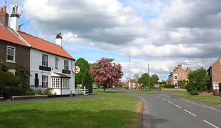
Upper Poppleton is a village and civil parish in the unitary authority of the City of York in North Yorkshire, England. It is situated by the west bank of the River Ouse adjacent to Nether Poppleton, and west of York close to the A59 from York to Harrogate. The village is served by Poppleton railway station on the Harrogate Line. According to the 2001 census, the parish had a population of 1,961, increasing to 1,997 at the 2011 Census. Before 1996, it was part of the Borough of Harrogate.

<span class="mw-page-title-main">Harrogate</span> Town in North Yorkshire, England

Harrogate is a spa town in the district and county of North Yorkshire, England. Historically in the West Riding of Yorkshire, the town is a tourist destination and its visitor attractions include its spa waters and RHS Harlow Carr gardens. 13 miles (21 km) away from the town centre is the Yorkshire Dales National Park and the Nidderdale AONB.

<span class="mw-page-title-main">Harrogate line</span> Passenger rail line in England

The Harrogate line is a passenger rail line through parts of North Yorkshire and the West Yorkshire area of northern England connecting Leeds to York by way of Harrogate and Knaresborough. Service on the line is operated by Northern, with a few additional workings by London North Eastern Railway starting and terminating at Harrogate. West Yorkshire Metro's bus and rail MetroCard ticket is available for journeys between Leeds and Harrogate.

Harrogate was a constituency represented in the House of Commons of the UK Parliament. As with all constituencies, the constituency elected one Member of Parliament (MP) by the first past the post system of election. The constituency was renamed Harrogate and Knaresborough in 1997.

<span class="mw-page-title-main">Skipton and Ripon (UK Parliament constituency)</span> Parliamentary constituency in the United Kingdom, 1983 onwards

Skipton and Ripon is a constituency in North Yorkshire represented in the House of Commons of the UK Parliament since 2010 by Julian Smith, a Conservative.
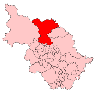
<span class="mw-page-title-main">Pateley Bridge</span> Market town in North Yorkshire, England

Pateley Bridge is a market town in Nidderdale in the county and district of North Yorkshire, England. Historically part of the West Riding of Yorkshire, it lies on the River Nidd. It is in the Yorkshire Dales and just outside the Yorkshire Dales National Park.

<span class="mw-page-title-main">Nidderdale</span> Valley in Yorkshire, England

Nidderdale, historically also known as Netherdale, is one of the Yorkshire Dales in North Yorkshire, England. It is the upper valley of the River Nidd, which flows south underground and then along the dale, forming several reservoirs including the Gouthwaite Reservoir, before turning east and eventually joining the River Ouse.
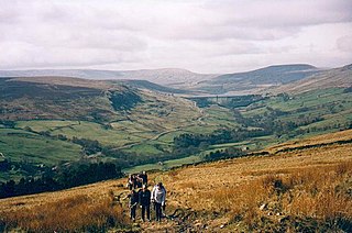
<span class="mw-page-title-main">Nidderdale AONB</span> Area of Outstanding Natural Beauty in England

The Nidderdale AONB is an Area of Outstanding Natural Beauty in North Yorkshire, England, bordering the Yorkshire Dales National Park to the east and south. It comprises most of Nidderdale itself, part of lower Wharfedale, the Washburn valley and part of lower Wensleydale, including Jervaulx Abbey and the side valleys west of the River Ure. It covers a total area of 233 square miles (600 km2). The highest point in the Nidderdale AONB is Great Whernside, 704 metres (2,310 ft) above sea level, on the border with the Yorkshire Dales National Park.

Nidderdale was a rural district in the West Riding of Yorkshire from 1938 to 1974. It was created from the combination of most of the disbanded rural districts of Great Ouseburn and Knaresborough.

Ripon and Pateley Bridge was a rural district in the West Riding of Yorkshire, England from 1937 to 1974.

<span class="mw-page-title-main">Ripon (UK Parliament constituency)</span> Parliamentary constituency in the United Kingdom, 1868–1983

Ripon was a constituency sending members to the House of Commons of the Parliament of the United Kingdom until 1983, centred on the city of Ripon in North Yorkshire.

<span class="mw-page-title-main">Nidderdale Museum</span> Local history museum in North Yorkshire, England

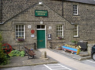
Nidderdale Museum is a local and social history museum in the market town of Pateley Bridge in Nidderdale, one of the Yorkshire Dales, in North Yorkshire, England. The museum is housed in a former workhouse, and is normally open every day from 1.30 p.m. to 4.30 p.m. from 1 April to 31 October, and on Saturdays and Sundays from 1.30 p.m. to 4.30 p.m. over the winter. There is a small entry charge for adults. Accompanied children are free.

<span class="mw-page-title-main">Nidderdale Greenway</span>

The Nidderdale Greenway is a 4-mile (6.4 km) path that runs between Harrogate and Ripley in North Yorkshire, England. It uses a former railway line that ran between Harrogate and Pateley Bridge as its course. The route connects to other cycle paths including the Way of the Roses.

<span class="mw-page-title-main">High and Low Bishopside</span> Civil parish in North Yorkshire, England

High and Low Bishopside is a civil parish in Nidderdale in the Harrogate district, in the county of North Yorkshire, England. It includes the town of Pateley Bridge and the villages of Glasshouses and Wilsill, the southern part of Wath and the hamlets of Blazefield, and Fellbeck. The parish touches Bewerley, Dacre, Eavestone, Fountains Earth, Hartwith cum Winsley, Laverton, Sawley, Stonebeck Down and Warsill. In 2011 the parish had a population of 2,210. There are 39 listed buildings in High and Low Bishopside. The parish's council is called "Pateley Bridge Town Council".

<span class="mw-page-title-main">Thomas Holroyd</span> British painter (1821–1904)

Thomas Holroyd was an English portrait and landscape painter working in Harrogate, North Riding of Yorkshire, England. Before his marriage he undertook painting tours to the United States, Canada, Europe, Egypt, Russia and the Holy Land. Returning to Harrogate, he painted portraits of the local worthies there. He shared responsibility for the successful photography business T & J Holroyd with his brother James, and continued to run the business after his brother died. Holroyd was a founding member of Harrogate Liberal Club.

<span class="mw-page-title-main">North Yorkshire (district)</span> Unitary authority area in England

North Yorkshire is a unitary authority area in the ceremonial county of North Yorkshire, Yorkshire and the Humber, England. It covers seven former districts: Craven, Hambleton, Harrogate, Scarborough, Richmondshire, Ryedale and Selby.

<span class="mw-page-title-main">Robert Ackrill</span> English newspaper owner (1816–1894)

Robert Ackrill was an English journalist, newspaper proprietor, founder of newspapers, printer and writer, working for most of his career in Harrogate, England. During the 19th century he owned six newspapers in the North Riding of Yorkshire via his company Ackrill Newspapers, having founded three of them. Ackrill's descendants and relatives continued to run or be involved with Ackrill newspapers for at least a hundred years, the final incarnation of the company under that name being dissolved in 2020.
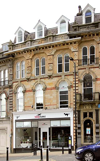
References

Commons-logo.svg Media related to Borough of Harrogate at Wikimedia Commons

  1. "Resident Population Estimates by Ethnic Group (Percentages); Mid-2005 Population Estimates". National Statistics Online. Office for National Statistics. Archived from the original on 3 March 2016. Retrieved 28 March 2008.
  2. UK Census (2011). "Local Area Report – Harrogate Local Authority (1946157115)". Nomis. Office for National Statistics . Retrieved 7 January 2019.
  3. "Next steps for new unitary councils in Cumbria, North Yorkshire and Somerset". GOV.UK. Retrieved 20 December 2021.
  4. "The new council". North Yorkshire County Council. 26 October 2020. Retrieved 20 December 2021.
  5. "Harrogate Borough Council Committee Information : Welcome". Localdemocracy.harrogate.gov.uk. Retrieved 2 January 2019.
  6. "Mr David Simpson, Death of first Freeman of Harrogate" . Yorkshire Evening Post. British Newspaper Archive. 15 January 1931. p. 7 col.2. Retrieved 22 December 2022.
  7. British Pathe (27 July 2021). "Freedom To Viceroy Elect (1926)" via YouTube.
  8. "Bettys ex-chief Jonathan Wild granted freedom of Harrogate". BBC News. 18 July 2012. Retrieved 12 September 2021.
  9. Webster, Jacob (10 September 2021). "Former Harrogate Advertiser editor to be given freedom of borough for 'service to community and journalism'". The Harrogate Advertiser. Retrieved 12 September 2021.


53°59′25″N1°32′28″W / 53.99028°N 1.54111°W / 53.99028; -1.54111