The town has the oldest sweet shop in the world. Established in 1827, it is housed in one of the earliest buildings in Pateley Bridge, dating from 1661.[3] Pateley Bridge is also the home of the Nidderdale Museum.
The last Dalesagricultural show of the year, the Nidderdale Show, is held annually on the showground by the River Nidd. The show attracts more than 14,000 visitors each year.
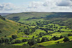
The town is within the Nidderdale National Landscape, an Area of Outstanding Natural Beauty.[4] The town was listed in both the 2017 and 2018 Sunday Times reports on Best Places to Live in northern England.[5] The local tourist authority bills it as "the perfect place to start your exploration of the Yorkshire Dales".[6]
History
St Cuthbert’s Church
In the early Middle Ages the site of Pateley lay in lands of the Archbishop of York, which came to be known as Bishopside. In the 12th century the principal settlement in Bishopside was at Wilsill, rather than Pateley.[7] Pateley was first recorded in 1175 (though the document survives in a later copy), as Patleiagate, with 14th century forms including Patheleybrig(ge). The final elements are clear, deriving from Old Norse gata ('street') and the northern dialect form brig ('bridge') respectively. The bridge is Pateley Bridge over the River Nidd.
There is more debate about the Pateley section of the name: the usual explanation is Old Englishpæþ ('path') in the genitive plural form paða + lēah ('open ground, clearing in a forest'); paða lēah would mean "woodland clearing of the paths", referring to paths up Nidderdale and from Ripon to Craven, which intersected here.[8] However, the Pateley name forms competed in the Middle Ages with forms like Padlewath (1227) and Patheslayewathe which could be from Middle English *padil ('a shallow place in water') + Old Norse vath ('ford') and it could be that they owe something to this name.[9] The local story that the name comes from 'Pate', an old Yorkshire dialect word for 'Badger',[10] is incorrect.[11]
Pateley Bridge Methodist Church
In 1320 the Archbishop of York granted a charter for a market and fair at Pateley.[12] From the 14th century until the early part of the 20th century, Scotgate Ash Quarry despatched hard-wearing sandstone from its site on the northern flank above Pateley Bridge. In 1862 the railway arrived in Nidderdale, and the stone was then exported by train and was used in railway platforms, national buildings and harbour walls. Scotgate Ash Quarry closed in 1915.[13]
All Creatures Great and Small TV series was filmed mostly in the Yorkshire Dales with many of the Dales scenes filmed in the National Park around Nidderdale.[15] The crossroads that are so important in the Christmas episode are "on the roads above Pateley Bridge".[16]
The town is in the electoral ward of Pateley Bridge, which includes the whole of upper Nidderdale as far as Stonebeck Up, with a total population at the 2011 Census of 2,718.[21]
Pateley Bridge is the largest settlement in the civil parish of High and Low Bishopside, Pateley Bridge was granted town status in 1986, and the High and Low Bishopside Parish Council was renamed Pateley Bridge Town Council.[22] However, the official name of the civil parish remains High and Low Bishopside.
The population of the Pateley Bridge Built-up area, which includes Bridgehousegate and Bewerley village, both outside the parish, was 1,432 in 2011.[1]
Local media
Local news and television programmes are provided by BBC Yorkshire and ITV Yorkshire. Television signals are received from the local relay TV transmitter. [23]
The town can be reached by bus from Harrogate (Harrogate Bus Company number 24 service). Nidderdale is also served by DalesBus services on summer Sundays. The nearest railway station is at Harrogate. Highway access is via A1(M) and the A61 to the east, and the A65, A59, M65 and M62 to the south.[26]
The town is also a cricketing hub, with several teams (known collectively as 'The Badgers') competing in various leagues. Crown green bowling is also a popular pastime.
Pateley is also served by Nidderdale Pool and Leisure Centre. Comprising a 20-metre swimming pool, gym, sports hall and two squash courts, the facility officially opened in 2005 after many years of local fundraising.
"Oldest Sweet Shop in England"
The town is also famous for the "Oldest Sweet Shop in England", which was established in 1827 and is validated as the longest continuous trading sweet shop in the world (Guinness World Records Book 2014); it is housed in one of the oldest buildings in Pateley Bridge, built in 1661.[27][28] The business had been owned for nearly 25 years by Keith Tordoff,[29] who sold it on to a new owner in March 2021.[30]
King Street workshops can be found on King Street and house a group of artists and designers. Their studios are open and they include jewellers, milliner, textile art and gifts, sculptors, fine artist and glassblowers.[31]
The AONB website provides specifics for activities within the Area of Outstanding Natural Beauty including maps of popular walks, and information on canoeing and kayaking, caving, climbing, cycling, fishing and horse riding.[26]
Madge Hill Campsite, east of Pateley Bridge, is maintained by a team from West Leeds Scout District. The site was presented to Farsley District Scouts in 1930 by the Hainsworth family. The site has a bunkhouse and space for camping.[32]
Climate
Like much of the British Isles, Pateley Bridge has a Temperate Maritime Climate. The warmest temperature recorded was 31.0°C (87.8°F) on 1 July 2015. The nearest location where data is available is Dishforth Airfield. It is particularly notable that the warmest and the coldest temperatures for May both occurred in 2010, within the space of just 12 days. The heatwave at the beginning of October 2011 was so extreme that the warmest October temperature was recorded, and it was higher than the record high of September in any year. With a mean temperature of 11.4°C (52.5°F), December 2015 was easily the warmest December ever recorded, and the warmest ever December temperature of 16.2°C (61.2°F) was reached on 19th. In contrast, the December 2010 mean temperature was −1.9°C (28.6°F), and the coldest ever temperature of −15.0°C (5.0°F) was reached on the 6th.[33]
Climate data for Pateley Bridge, 154m amsl (1981–2010) (extremes 1992–)
↑ Smith, A.H. (1961). The Place-names of the West Riding of Yorkshire. Vol.5. Cambridge University Press. p.149.
↑ Victor Watts (ed.), The Cambridge Dictionary of English Place-Names Based on the Collections of the English Place-Name Society (Cambridge: Cambridge University Press, 2004), s.v. PATELEY BRIDGE.
This page is based on this Wikipedia article Text is available under the CC BY-SA 4.0 license; additional terms may apply. Images, videos and audio are available under their respective licenses.