Ribblesdale

Last updated

View across the valley from Moughton Nab Across Ribblesdale from Moughton Nab - geograph.org.uk - 1502626.jpg
View across the valley from Moughton Nab

Ribblesdale is one of the Yorkshire Dales in England. It is the dale or upper valley of the River Ribble in North Yorkshire. Towns and villages in Ribblesdale (downstream, from north to south) include Selside, Horton-in-Ribblesdale, Stainforth, Langcliffe, Giggleswick, Settle, Long Preston and Hellifield. Below Hellifield (sometimes below Settle [1] ) the valley of the river is generally known as the Ribble Valley.

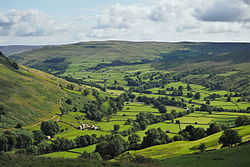
Above Settle the dale is within the Yorkshire Dales National Park. It is a popular tourist area, particularly for walking. The Yorkshire Three Peaks rise to the east and west of the dale. The Ribble Way runs the length of the dale. At the head of the dale is the Ribblehead Viaduct, crossed by the Settle to Carlisle railway which runs through the dale. Quarrying has been an important industry within the dale, and three quarries are still being worked; Arcow and Dry Rigg quarries produce gritstone (greywacke), and Horton Quarry produces limestone. [2]

The dale was historically in the West Riding of Yorkshire. In 1974 it became part of the Craven district in the new county of North Yorkshire.

Related Research Articles

<span class="mw-page-title-main">Yorkshire Dales</span> Upland area of the Pennines in Northern England

The Yorkshire Dales are an upland area of the Pennines in England. Most of the area is in the county of North Yorkshire, but it extends into Cumbria and a small part of Lancashire. It was historically entirely within Yorkshire. The majority of the Dales are part of the Yorkshire Dales National Park, created in 1954. The exception is the area around Nidderdale, which forms the separate Nidderdale Area of Outstanding Natural Beauty.

<span class="mw-page-title-main">Craven District</span> Former local government district in England

Craven was a non-metropolitan district in the west of North Yorkshire, centred on the market town of Skipton.

<span class="mw-page-title-main">Yorkshire Three Peaks</span> Mountainous peaks in the Yorkshire Dales National Park

The mountains of Whernside, Ingleborough and Pen-y-ghent are collectively known as the Three Peaks. The peaks, which form part of the Pennine range, encircle the head of the valley of the River Ribble in the Yorkshire Dales National Park in the North of England.

<span class="mw-page-title-main">River Ribble</span> River in North Yorkshire and Lancashire, England

The River Ribble runs through North Yorkshire and Lancashire in Northern England. It starts close to the Ribblehead Viaduct in North Yorkshire, and is one of the few that start in the Yorkshire Dales and flow westwards towards the Irish Sea.

<span class="mw-page-title-main">Horton in Ribblesdale</span> Village and civil parish in North Yorkshire, England

Horton in Ribblesdale is a small village and civil parish in the Craven district of North Yorkshire, England. It is situated in Ribblesdale on the Settle–Carlisle Railway to the west of Pen-y-ghent.

<span class="mw-page-title-main">Horton-in-Ribblesdale railway station</span> Railway station in North Yorkshire, England

Horton-in-Ribblesdale is a railway station on the Settle and Carlisle Line, which runs between Carlisle and Leeds via Settle. The station, situated 47 miles 40 chains (76.4 km) north-west of Leeds, serves the village of Horton-in-Ribblesdale, Craven in North Yorkshire, England. It is owned by Network Rail and managed by Northern Trains.

The Ribble way is a long-distance walk between the Lancashire coast and the Yorkshire Dales National Park largely following the course of the River Ribble.

<span class="mw-page-title-main">Ribblehead</span> Area near the River Ribble in North Yorkshire, England

<span class="mw-page-title-main">Gisburn</span> Human settlement in England

Gisburn is a village and civil parish within the Ribble Valley borough of Lancashire, England. Historically within the West Riding of Yorkshire, it lies 8 miles (13 km) northeast of Clitheroe and 11 miles (18 km) west of Skipton. The civil parish had a population of 506, recorded in the 2001 census, increasing to 521 at the 2011 Census.

<span class="mw-page-title-main">Aire Gap</span> Geological feature in England

Aire Gap is a pass through the Pennines in England formed by geologic faults and carved out by glaciers. The term is used to describe a geological division, a travel route, or a location that is an entry into the Aire river valley.

<span class="mw-page-title-main">Dales High Way</span>

A Dales High Way is a long-distance footpath in northern England. It is 90 miles (140 km) long and runs from Saltaire in West Yorkshire to Appleby-in-Westmorland, Cumbria, roughly parallel to the line of the Settle and Carlisle Railway.

<span class="mw-page-title-main">DalesRail</span> Seasonal passenger railway service in Northern England

DalesRail is a railway passenger service operated for tourism in the summer months across Cumbria, Lancashire and North Yorkshire, England. The service routinely uses the current freight-only line between Clitheroe and Hellifield, offering the opportunity to travel on a line rarely used by passenger trains. The trains then also traverse the full length of the Settle & Carlisle line. The DalesRail brand has also been used on the Wensleydale Line in the 1970s and 1980s, before that line reopened as a heritage railway.

<span class="mw-page-title-main">Horton Quarry</span> Limestone quarry in North Yorkshire, England

Horton Quarry is a limestone quarry near to Horton-in-Ribblesdale, North Yorkshire, England. The quarry, which is some 6 miles (9.7 km) north of Settle, has been operating since at least 1889, and produces limestone for a variety of purposes. Stone used to be exported from the quarry by rail, but now leaves by lorry, although there are plans to re-instate the railway sidings. The quarry used to produce its own lime by roasting the limestone in big kilns on the site, but the last of these were removed in the 1980s. Since 2000, the quarry has been owned and operated by Hanson.

<span class="mw-page-title-main">Crummackdale</span> A valley in North Yorkshire, England

Crummackdale,, is a small valley north of the village of Austwick in the Craven District of North Yorkshire, England. The Valley is drained by Austwick Beck, which flows into the River Wenning, which in turn heads westwards to empty into the Irish Sea. Crummackdale is a narrow south west facing dale, at the south west corner of the Yorkshire Dales National Park.

<span class="mw-page-title-main">Stainforth Force</span> Waterfall in North Yorkshire, England

Stainforth Force, is a 2.5-metre high cascade waterfall on the River Ribble at Stainforth, 3 miles (5 km) north of Settle in North Yorkshire, England. The waterfall is a popular tourist attraction in autumn when salmon are migrating up the river.

<span class="mw-page-title-main">Dry Rigg Quarry</span> Gritstone quarry in North Yorkshire, England

Dry Rigg Quarry is a quarry at Helwith Bridge in North Yorkshire, England, located within the Yorkshire Dales National Park. The quarry produces a hard-wearing gritstone which is listed as being nationally important for road building, and is one of four in the Yorkshire Dales National Park that produces this type of aggregate. The quarry operations have come under public scrutiny due to the amount of road traffic, leading to some of the output from Dry Rigg being moved from the adjacent railhead at Arcow Quarry. The quarry is situated in Upper Ribblesdale some 1.9 miles (3 km) south of Horton-in-Ribblesdale, and 5 miles (8 km) north of Settle.

The geology of the Yorkshire Dales National Park in northern England largely consists of a sequence of sedimentary rocks of Ordovician to Permian age. The core area of the Yorkshire Dales is formed from a layer-cake of limestones, sandstones and mudstones laid down during the Carboniferous period. It is noted for its karst landscape which includes extensive areas of limestone pavement and large numbers of caves including Britain's longest cave network.

<span class="mw-page-title-main">Wether Fell</span> Peak in the Yorkshire Dales, England

Wether Fell, also known as Drumaldrace, is a mountain in the Yorkshire Dales National Park, in North Yorkshire, England. Wether Fell is mountain that divides Wensleydale in the north and Upper Wharfedale in the south. Its summit is 614 metres (2,014 ft). A Roman Road, the Cam High Road, passes along the southern edge of the summit reaching 1,900 feet (580 m).

<span class="mw-page-title-main">Gisburn Tunnel</span> Railway tunnel in Lancashire, England

Gisburn Tunnel is a short railway tunnel on the Ribble Valley line in Lancashire, England. The tunnel is 157 yards (144 m) long, just to the east of Gisburn railway station, curving slightly under Gisburne Park. The tunnel was reputedly built at the behest of Lord Ribblesdale, who didn't want the railway across his land. The line through the tunnel connects Blackburn, Clitheroe and Hellifield, and is an important railway route for freight trains.

References

  1. Yorkshire Dales website The Ordnance Survey map marks the valley between Settle and Hellifield as Ribblesdale.
  2. "LCA 13 Ribblesdale Landscape Character Assessment Yorkshire Dales National Park" (PDF). yorkshiredales.org.uk. p. 4. Retrieved 10 February 2022.

54°08′39.6″N2°17′46.8″W / 54.144333°N 2.296333°W / 54.144333; -2.296333

Commons-logo.svg Media related to Ribblesdale at Wikimedia Commons