Otoyol

Last updated
Otoyol
Turkey road sign B-18 (2).svg
O1-TR sign.svg O20-TR sign.svg O30-TR sign.svg
Route markers for three Turkish Motorways
Motorway Map of Turkey (revised).png
Otoyol network in Turkey. Motorways in use, under construction and projected.
System information
Maintained by Karayolları Genel Müdürlüğü
Formed1968 [1]
Highway names
Otoyols:Otoyol XX (O-XX)
System links

The Otoyol (Plural: Otoyollar) is the national network of controlled-access highways in Turkey. The term Otoyol translates to motorway while the literal meaning is auto-route. The Otoyol was first opened in 1973.

Contents

As of December 2023, there are 3,726 km of otoyol in service, the network passes through 28 provinces out of 81 in Turkey. [2]

The system previously consisted of three separate networks; the Edirne-Istanbul-Ankara corridor, the Aegean network centred on İzmir and the Southeastern network centred on Adana. With the completion of the O-5 in 2019 and the extension of the O-21 in 2020, these three networks have since been connected. The network is expected to expand to 8,325 kilometres (5,173 mi) by 2053. [3] The minimum speed limit on the Turkish otoyols is 40 km/h (25 mph) while the maximum speed is 140 km/h (87 mph). [4]

History

The construction of a national road system was prioritized in 1948, where the construction of new roads were greatly accelerated. This led to a rise in automobile usage in Turkey. By the 1960s, traffic problems were becoming prevalent in large cities and capacity on intercity roads needed to be upgraded. Plans to build new expressways were put into action in 1968, when construction of the Istanbul Inner Beltway was started. [5] The Beltway, known as the O-1, was opened together with the Bosporus Bridge in 1973 with great fanfare. This became the first motorway to be built in Turkey. The Istanbul Beltway was then to be a part of a large expressway spanning from Edirne, in East Thrace, to İskenderun, on the eastern shore of the Mediterranean Sea. Construction of this expressway first started in 1973 on a 14 km (8.7 mi) section between Pozantı and Akçatekir, on what would become the O-21. In 1975 construction of a 40 km (25 mi) section of the motorway from Gebze to Izmit was started. Due to financial problems during the following years, construction of the two otoyols were greatly slowed down. It wasn't until 1984 that these two motorways were opened to traffic. [1]

Turgut Özal became Prime Minister in 1983 and brought forth a policy of constructing new otoyols in Turkey. In 1985, construction of an intercontinental motorway spanning 772 km (480 mi) from Edirne to Ankara was started. This motorway project would serve as an outer beltway round Istanbul and also included the construction of a second bridge over the Bosporus, the Fatih Sultan Mehmet Bridge. The first section of the motorway, the 20 km (12 mi) long Edirne Beltway, was opened in 1987, followed by the opening of the Outer Beltway in Istanbul, from Levent to Kozyatağı, together with the FSM Bridge on 3 July 1988. The motorway was opened in sections in the following years until being completed in 1994. 2 decades later O-7 or Third Beltway opened in 2017.

In 1988 the construction of three new motorways in Izmir were started. O-32 opened in 1992 and it became first motorway in Agean Region. O-30 was built a year after. And a year after O-31 was opened, running between İzmir and Aydın. Finally in 2008, O-30 was completed. First section of O-5 was opened between Kemalpaşa and Bornova, after that in 2019 the motorway opened by phases section between Balıkesir junctions opened in 2018 and Kemalpaşa and Akhisar section was opened in March 2019 and in August 2019 remaining sections opened between Akhisar and Balıkesir West, Balıkesir North and Bursa West junctions. In 2020 two new motorways opened to the traffic. O-33 was opened in February 2020, as a continuous part of O-30, and in November 2020 the first section of O-21 extension was opened and in December 2020 was fully opened to Niğde. In 2021 the 8th phase of O-7 opened, and on 18 March 2022 Otoyol-6 opened between Malkara and Lapseki. Including the 1915 Çanakkale Bridge.

Today, two motorway extensions under construction: In O-7 9th phase between Nakkaş-Başakşehir link road and O-31 extension to Denizli, opening in 2023.

Network map

Otoyol
Interactive map of highways of Turkey

List of Otoyol routes

NumberLength (km)Length (mi)Northern or western terminusSouthern or eastern terminusOpenedNotes
O1-TR sign.svg O-1 20.512.7 D100-TR.svg in Eyüp, Istanbul Bağdat Ave. in Kadıköy, Istanbul 1970 - 1973 Istanbul Inner Beltway including the Bosphorus Bridge
O2-TR sign.svg O-2 36.922.9O3-TR sign.svg O-3 in Mahmutbey, Istanbul D100-TR.svg in Kozyatağı, Istanbul 1986 -1988 Istanbul Outer Beltway including the Fatih Sultan Mehmet Bridge
O3-TR sign.svg O-3 246.9153.4 D100-TR.svg near Edirne D100-TR.svg in Eyüp, Istanbul 1987İstanbul-Edirne (Bulgaria-Greece-Turkey border) Motorway
O4-TR sign.svg O-4 372231.2O2-TR sign.svg O-2/O1-O2 connector in Ataşehir, Istanbul O20-TR sign.svg O-20 near Sincan, Ankara 1984 - 2007İstanbul-Ankara Motorway, including the Mount Bolu Tunnel
O5-TR sign.svg O-5 409.4254.4O4-TR sign.svg O-4 near Gebze, Kocaeli O30-TR sign.svg O-30 in Bornova, Izmir 2016 - 2019İstanbul-Bursa-İzmir Motorway, including the Osmangazi Bridge and the Orhangazi Tunnel
O6-TR sign.svg O-6 10162.8 D110-TR.svg near Malkara, Tekirdağ D200-TR.svg near Lapseki, Çanakkale 2022The section containing the Çanakkale 1915 Bridge was opened in March 2022
O7-TR sign.svg O-7 275.2171.1O3-TR sign.svg O-3 near Kınalı, Istanbul O4-TR sign.svg O-4 near Akyazı, Sakarya 2016 - 2020Northern Marmara Motorway, Contains the northernmost beltway of İstanbul, including the Yavuz Sultan Selim Bridge
O20-TR sign.svg O-20 11068.4Road forms complete ring around AnkaraRoad forms complete ring around Ankara1987 Ankara Beltway
O21-TR sign.svg O-21 399.5248.3O20-TR sign.svg O-20 near Gölbaşı, Ankara D400-TR.svg near Tarsus, Mersin 1984 - 2020Ankara-Çukurova Motorway
O21A-TR sign.svg O-21A 3219.9 D330-TR.svg near Çakmak Bucağı, Konya O21-TR sign.svg O-21 near Eminlik, Niğde 1992
O22-TR sign.svg O-22 34.121.2O5-TR sign.svg O-5 near Çağlıyan, Bursa D160-TR.svg near Turanköy, Bursa 2006
O30-TR sign.svg O-30 60.437.5O32-TR sign.svg O-32 in Balçova, Izmir O33-TR sign.svg O-33 in Çiğli, Izmir 1993 - 2006 İzmir Beltway
O31-TR sign.svg O-31 127.879.4O30-TR sign.svg O-30 in Buca, Izmir D550-TR.svg in Aydın 1996 - 2004İzmir-Aydın Motorway
O32-TR sign.svg O-32 77.748.31065 Sk. in Çeşme Mustafa Kemal Sahil Blv. in Balçova, Izmir 1992 - 1996İzmir-Çeşme Motorway
O33-TR sign.svg O-33 55.234.3Çandarlı Connector near Çandarlı O30-TR sign.svg O-30 in Çiğli, İzmir 2019Northern Aegean Motorway
O51-TR sign.svg O-51 99.261.6 D400-TR.svg in Çeşmeli, Mersin O52-TR sign.svg O-52 in Adana 1992Adana-Mersin Motorway
O52-TR sign.svg O-52 365226.8O51-TR sign.svg O-51 in Adana D400-TR.svg near Şanlıurfa 1992Adana-Gaziantep-Şanlıurfa Motorway
O53-TR sign.svg O-53 15093.2O52-TR sign.svg O-52 near Ceyhan D817-TR.svg in İskenderun 1993
O54-TR sign.svg O-54 3521.7 D400-TR.svg in Gaziantep O52-TR sign.svg O-52 in Gaziantep 2013 Gaziantep Beltway

Future Projects

The motorway network is expected to reach 8,325 kilometres (5,172 mi) by 2053. [6] Future projects can be seen in the chart below:

Under Construction

NumberLength (km)Length (mi)Northern or western terminusSouthern or eastern terminusOpensNotes
O31-TR sign.svg O-31 165102.5O31-TR sign.svg O-31in Aydın D320-TR.svg in Pınarkent, Denizli 2023
O7-TR sign.svg O-7 4528O7-TR sign.svg O-7 near Nakkaş, Istanbul O7-TR sign.svg O-7 near Başakşehir, Istanbul 2023

Tender Phase

NumberLength (km)Length (mi)Northern or western terminusSouthern or eastern terminusTender DateNotes
O51-TR sign.svg O-51 9860.9 D400-TR.svg in Taşucu O51-TR sign.svg O-51 near Çeşmeli, Mersin 23.09.2021
O6-TR sign.svg O-6 11470.8 D110-TR.svg near Malkara, Tekirdağ O3-TR sign.svg O-3 near Kınalı, Istanbul N/APart of Kınalı-Balıkesir Motorway.
O-TR sign.svg 11973.9O20-TR sign.svg O-20 in Mamak, Ankara D200-TR.svg in Delice N/APart of Ankara-Samsun Motorway. Delice-Samsun section still in planning phase.
O-TR sign.svg 13080.8O22-TR sign.svg O-22 in Sivrihisar O20-TR sign.svg O-20 in Tulumtaş, Ankara N/APart of Izmir–Ankara Motorway. İzmir-Sivrihisar section still in planning phase.
O-TR sign.svg 13785.2O4-TR sign.svg O-4 in Gerede D100-TR.svg in Ilgaz N/APart of Gerede-Gürbulak Motorway  [ tr ]. Ilgaz-Merzifon-Koyulhisar-Pülümür-Horasan-Gürbulak sections still in planning phase.
O51-TR sign.svg O-51 15596.3 D685-TR.svg in Antalya D400-TR.svg in Alanya N/APart of Afyon-Antalya-Alanya Motorway  [ tr ]. Afyonkarahisar-Burdur-Antalya section still in planning phase.
O-TR sign.svg 31.319.5O53-TR sign.svg O-53 near Dörtyol, Hatay D825-TR.svg near Hassa, Hatay N/ADörtyol-Hassa Motorway

Planning Phase

NumberLength (km)Length (mi)Northern or western terminusSouthern or eastern terminusTender DateNotes
O-TR sign.svg 127.46O30-TR sign.svg O-30 near Sasalı, İzmir O30-TR sign.svg O-30 near İnciraltı, İzmir N/A İZKARAY  [ tr ] - Gulf of İzmir Passage Project between Çiğli (Sasalı) and Balçova (İnciraltı); including one undersea tunnel and one bridge
O-TR sign.svg 4125.5O33-TR sign.svg O-33 near Menemen, İzmir O30-TR sign.svg O-30 near Buca, İzmir N/Aİzmir 2. peripheral motorway
O31-TR sign.svg O-31 15596.3O31-TR sign.svg O-31 in Denizli D650-TR.svg near Bucak, Burdur N/ADenizli-Burdur section of Aydın-Denizli-Burdur Motorway
O6-TR sign.svg O-6 13785.1 D200-TR.svg near Lapseki, Çanakkale O5-TR sign.svg O-5 near Balıkesir N/ALapseki-Balıkesir section of Kınalı-Balıkesir Motorway
O-TR sign.svg 350217.5 D650-TR.svg } near Afyonkarahisar D650-TR.svg near Antalya N/A Afyonkarahisar-Burdur-Antalya Motorway  [ tr ]
O-TR sign.svg 408253.5O5-TR sign.svg O-5 near Turgutlu, Manisa O22-TR sign.svg O-22 near Sivrihisar N/ASivrihisar-İzmir section of Ankara-İzmir Motorway
O22-TR sign.svg O-22 231143.5O5-TR sign.svg O-5 near Kestel, Bursa O22-TR sign.svg O-22 near Sivrihisar, Eskişehir N/ASivrihisar-Bursa Motorway
O52-TR sign.svg O-52 454282.1O52-TR sign.svg O-52 near Şanlıurfa D430-TR.svg near Habur, Silopi, Şırnak N/AŞanlıurfa-Mardin-Habur Motorway (including link to Diyarbakır) (border crossing)
O-TR sign.svg 303188.3 D795-TR.svg near Samsun D200-TR.svg near Delice N/ADelice-Samsun section of Ankara-Samsun Motorway
O-TR sign.svg 14489.5 D010-TR.svg near Bafra, Samsun D010-TR.svg near Ünye, Ordu N/ABafra-Samsun-Ünye Motorway
O-TR sign.svg 183113.7 D100-TR.svg near Ilgaz, Çankırı D100-TR.svg near Merzifon, Amasya N/A Ilgaz-Merzifon Motorway  [ tr ]
O-TR sign.svg 919571 D100-TR.svg near Merzifon, Amasya D100-TR.svg near Gürbulak, Doğubayazıt, Ağrı N/A Merzifon-Gürbulak Motorway  [ tr ] (border crossing)
O-TR sign.svg 9156.6O5-TR sign.svg O-5 near Yalova O4-TR sign.svg O-4 near İzmit, Kocaeli N/A Yalova-İzmit Motorway  [ tr ]
O-TR sign.svg 440273.4 D650-TR.svg near Afyonkarahisar D330-TR.svg near Ulukışla, Niğde N/AAfyonkarahisar-Konya-Ereğli-Niğde (Ulukışla) Motorway
O-TR sign.svg 10565.3 D200-TR.svg near Bozüyük, Bilecik D650-TR.svg near Afyonkarahisar N/ABozüyük-Afyonkarahisar Motorway
O51-TR sign.svg O-51 200124.3 D400-TR.svg near Alanya, Antalya D400-TR.svg near Silifke, Mersin N/AAlanya-Silifke Motorway
O-TR sign.svg 10565.3O4-TR sign.svg O-4 near Düzce D010-TR.svg near Zonguldak N/ADüzce-Zonguldak Motorway
O-TR sign.svg 500310.7 D200-TR.svg near Delice D100-TR.svg near Refahiye, Erzincan N/ADelice-Sivas-Refahiye Motorway
O-TR sign.svg 600372.8O21-TR sign.svg O-21 near Nevşehir D885-TR.svg near Diyarbakır N/ANevşehir-Kayseri-Malatya-Diyarbakır Motorway
O-TR sign.svg 220136.7 D200-TR.svg near Sivas D300-TR.svg near Malatya N/ASivas-Malatya Motorway
O-TR sign.svg 5031.1O52-TR sign.svg O-52 near Şanlıurfa D885-TR.svg near Akçakale, Şanlıurfa N/AŞanlıurfa-Akçakale Motorway (border crossing)
O-TR sign.svg 475295.2 D885-TR.svg near Diyarbakır D100-TR.svg near Gürbulak, Doğubayazıt, Ağrı N/ADiyarbakır-Gürbulak Motorway (border crossing)
O-TR sign.svg 540335.6 D010-TR.svg near Trabzon D825-TR.svg near Kahramanmaraş N/ATrabzon-Refahiye-Malatya-Kahramanmaraş Motorway
O-TR sign.svg 250155.4 D100-TR.svg near Pasinler, Erzurum D955-TR.svg near Türkgözü, Posof, Ardahan N/APasinler-Türkgözü Motorway (border crossing)
O-TR sign.svg 460285.8 D100-TR.svg near Rize D885-TR.svg near Diyarbakır N/ARize-Erzurum-Diyarbakır Motorway
O53-TR sign.svg O-53 7848.5O53-TR sign.svg O-53 near İskenderun, Hatay D420-TR.svg near Cilvegözü, Reyhanlı, Hatay N/Aİskenderun-Cilvegözü Motorway (border crossing)
O33-TR sign.svg O-33 8049.7O33-TR sign.svg O-33 near Çandarlı, Dikili, İzmir O5-TR sign.svg O-5 near Savaştepe, Balıkesir N/AÇandarlı-Bergama-Savaştepe Motorway
O-TR sign.svg 9055.9O31-TR sign.svg O-31 near Aydın D330-TR.svg near Muğla N/AAydın-Muğla Motorway
O-TR sign.svg 7546.6 D110-TR.svg near İpsala, Edirne D110-TR.svg near Malkara, Tekirdağ N/AMalkara-İpsala Motorway (border crossing)
O-TR sign.svg 13080.8O3-TR sign.svg O-3 near Havsa, Edirne D550-TR.svg near Kavakköy, Gelibolu, Çanakkale N/AHavsa-Gelibolu Motorway
O-TR sign.svg 180111.9 D200-TR.svg near Lapseki, Çanakkale O5-TR sign.svg O-5 near Karacabey, Bursa N/ALapseki-Karacabey Motorway

Toll

Most motorways are toll roads. The toll is based on the distance traveled. On most sections, the toll can be paid only with RFID-based HGS. Cash, OGS (active RFID) and KGS (card) methods have been abolished in recent years. Only the newly opened Otoyol 5, and Otoyol 7 have sections where it is possible to pay by cash or with credit card. Apart from motorways, the other state roads in Turkey are free of charge.

The revenue from tolls in 2001 were still about $203 million, rising by 2012 to approximately $542 million. In 2012, the Bosphorus bridges saw 150 million vehicles pass and the other toll roads saw over 210 million vehicles. [7] In 2015, both bridges were used by 141 million vehicles while the other toll motorways were used by 271 million vehicles, generating a total revenue of $391 million (both bridges and motorways combined). [8]

Standards

Otoyol 5 near Altinova exit Osman Gazi Koprusu, Altinova ayagindan kopruye giris istikameti.jpg
Otoyol 5 near Altınova exit

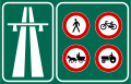
Mainly because the country already has a wide network of double carriageways, the standards for motorways in comparison are very high. Most sections of otoyols have 3 lanes in each direction, aside from the O-4 around Izmit, a small stretch of the O-3 between Silivri and Esenyurt, and the section of O-32 between Alaçatı and Çeşme, which only have two lanes in each direction. Also the O-2, the O-7 and the O-20 all have four lanes in each direction along the entire route. The lanes are each 3.75 meters wide. Most exits have a connection road, which helps avoiding wrong-way driving and illegal access to the road (bikes, tractors and horses are not allowed on otoyols).

The minimum speed is 40 km/h (25 mph) and the maximum allowed speed is 120 km/h (75 mph), although speeding is not punished under 132 km/h (82 mph). However, on sections of the O-1 through central Istanbul the speed limit is 70 km/h (43 mph). In most tunnels the speed limit is 90 km/h (56 mph).

Alongside otoyols, there are resting areas, which are standardized as A, B, C and D type service areas. The D type is mainly a parking area. The C type has a fuel station added. The B type has a fuel station and a vehicle service station added. The A type additionally has a motel (in urban ones, this motel is traded for a large shopping mall).

Dangerous stretches such as tunnels or bridges where there is often fog, exits, interchanges and service areas are illuminated.

Since gradients are expected to be very low and turning radii are expected to be very high, otoyols have many bridges and tunnels which makes them very expensive to construct.

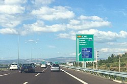
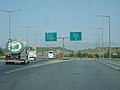
Otoyol signs in Turkey are green and uses the Highway Gothic typeface.

Statistics

Otoyol
Map of the highways in the Otoyol network

Length

Provinces

See also

Related Research Articles

<span class="mw-page-title-main">Transport in Turkey</span>

Transport in Turkey is road-dominated and mostly fuelled by diesel. Transport consumes a quarter of energy in Turkey, and is a major source of air pollution in Turkey and greenhouse gas emissions by Turkey. The World Health Organization has called for more active transport such as cycling.

<span class="mw-page-title-main">Otoyol 31</span>

Otoyol 31, named the İzmir-Aydın Motorway or just the Aydın Motorway and abbreviated as the O-31 is a 127.8 km (79.4 mi) long toll motorway in western Turkey. Beginning at an intersection with İzmir Beltway, the O-31 runs south from İzmir to Aydın and parallels the D550 for most of its route.

<span class="mw-page-title-main">Otoyol 30</span>

Otoyol 30, also known as the Izmir Beltway and abbreviated as the O-30, is a 60.2 km (37.4 mi) long motorway that runs around the Gulf of Izmir from Balçova to Menemen. The motorway acts as a bypass for through-traffic around the city and connects to four other motorways; O-5, O-31, O-32 and O-33. For most of its route, the O-30 runs along the perimeter of Izmir, but enters urbanized areas in Balçova, Bornova, Karşıyaka and Çiğli. The entire motorway has six lanes and is a part of the E87 and E881.

<span class="mw-page-title-main">Otoyol 2</span> Highway in Turkey

Otoyol 2, abbreviated as O-2, locally referred to as 2. Çevreyolu, is a motorway in Istanbul, Turkey that forms the outer ring road of the city connecting European and Asian parts via the Fatih Sultan Mehmet Bridge.

<span class="mw-page-title-main">Otoyol 3</span>

Otoyol 3, also known as the European Motorway and abbreviated as the O-3 is a 245.1 km (152.3 mi) long otoyol in East Thrace, Turkey. The O-3 runs from Edirne to Istanbul and is the only motorway in Turkey located entirely in Europe. The motorway begins west of Edirne at a junction with the D.100 where it then continues as a beltway passing just north of Edirne. From there, the motorway passes through mostly rural farmland until it enters the Istanbul metropolis near Silivri. The eastern end of the O-3 is at the interchange with the O-1, where the motorway becomes Vatan Caddesi and continues into the historic peninsula of Istanbul as a major boulevard.

<span class="mw-page-title-main">Otoyol 4</span> Highway in Turkey

Otoyol 4, named Anatolian Motorway and abbreviated as O-4, is a toll motorway connecting the northwestern Marmara Region to the Central Anatolia Region in Turkey. It runs parallel to the D.100 for more than half of its length and then parallels the D750 for most of the eastern half. The O-4 is a major expressway in Turkey as it connects eastern Istanbul and the heavily urbanized northeastern shore of the Sea of Marmara to the nation's capital, Ankara. The O-4 also makes up part of the International E-road network E80 and E89 as well as the AH-1 of the Asian Highway Network.

<span class="mw-page-title-main">Turkish State Railways</span> Turkish government-owned national railway company

The State Railways of the Republic of Turkey, abbreviated as TCDD, is a government-owned national railway company responsible with the ownership and maintenance of railway infrastructure in Turkey, as well as the planning and construction of new lines. TCDD was formed on 4 June 1929 as part of the nationalisation of railways in Turkey.

<span class="mw-page-title-main">Yüksek Hızlı Tren</span> Turkish high-speed rail service

Yüksek Hızlı Tren or YHT is a high-speed rail service in Turkey, operated by TCDD Taşımacılık, and is the railway's premier intercity train service. As of 2022, the network spans 1,385 km (860.6 mi) and services major cities like Istanbul, Ankara, Eskişehir, İzmit, Konya and Sivas. Expansion of the system is underway and the network is expected to reach Edirne, Afyonkarahisar, Adana and İzmir in the 2020s.

<span class="mw-page-title-main">General Directorate of Highways (Turkey)</span> Turkish state agency in charge of public roads

The General Directorate Of Highways (KGM) is a state agency in charge of the construction and maintenance of all public roadways outside of cities and towns in Turkey. It was established on 1 March 1950, following the acceptance of the International Highways Act in 1949. The agency is a sub unit of the Ministry of Transport and Infrastructure.

<span class="mw-page-title-main">Otoyol 50</span> Highway in Turkey

Otoyol 50, abbreviated as O-50, aka Adana Çevreyolu, was the former designation for the 22 km (14 mi) long motorway passing through the city of Adana, Turkey. In the 2014 the KGM resigned the section of motorway west of the Seyhan River as the O-51 and the section west of the Seyhan River as O-52. Thus extending the O-52 and O-51 into central Adana.

İzmir is a transportation hub for western Anatolia. İzmir has an extensive bus system, a developing metro, commuter rail system and a large urban ferry network. The city has highways connecting it to Çeşme, Menemen, Istanbul, Bursa and Aydın as well as a beltway. Mass transportation is operated by four separate public agencies all owned by the İzmir Municipality.

<span class="mw-page-title-main">Bayraklı Tunnels</span>

Bayraklı Tunnels, formerly Karşıyaka Tunnels, are two motorway tunnels in series located on the İzmir's northern beltway, motorway O-30 E87, in Bayraklı district between Karşıyaka and Bornova of Izmir Province, western Turkey.

<span class="mw-page-title-main">Otoyol 5</span> Highway in Turkey

Otoyol 5, named the Gebze-Orhangazi-İzmir Motorway and abbreviated as O-5, is a toll motorway in Turkey. Since being completed in 2019, it connects the Istanbul metropolitan area with İzmir, via Bursa and Balıkesir. The O-5 runs parallel to the D575 and the D565 for most of its length and is a major motorway in Turkey as it provides a direct connection between Istanbul and its surrounding metropolis to the country's 3rd largest (İzmir) and 4th largest (Bursa) cities, bypassing the Gulf of İzmit via the Osman Gazi Bridge. The O-5 also makes up part of the International E-road network E881.

The Çakıt Tunnel, is a motorway tunnel constructed on the Ankara–Tarsus motorway O-21 E90 in Adana Province, southern Turkey.

<span class="mw-page-title-main">Otoyol 6</span> Highway in Turkey

Otoyol 6, named the Kınalı-Balıkesir Motorway and abbreviated as O-6, is a planned 321-kilometre-long (199 mi) toll motorway in Turkey, with an 82 km (51 mi) section between Malkara and Lapseki open to traffic. When complete, the route will begin at Malkara, travel south to Çanakkale, cross the Dardanelles via the 1915 Çanakkale Bridge, and terminate at Balıkesir; connecting western Anatolia with East Thrace. The route is the first motorway in Turkey outside of Istanbul to connect the European and the Asian parts of the country.

<span class="mw-page-title-main">Otoyol 7</span> Toll motorway in Istanbul

The Otoyol 7, or Kuzey Marmara Otoyolu, is a toll motorway in Turkey that bypasses Istanbul to the north. The motorway is 243 km in length between the Kınalı junction and the Akyazı junction, and is 8 lanes wide.

References

  1. 1 2 Muhteşem Kaynak - Türkiye'de Otoyollar
  2. "YILLAR İTİBARIYLA YAPIMI TAMAMLANMIŞ OTOYOLLAR [Motorway completed by years] (2023)" (PDF). kgm.gov.tr. Karayolları Genel Müdürlüğü (KGM). Retrieved 2024-01-05.
  3. "Bakan Karaismailoğlu: Hedefimiz 2053'e kadar otoyol uzunluğumuzu 8 bin 325 kilometreye ulaştırmak" (in Turkish). aa.com.tr. 2022-12-06. Archived from the original on 2022-12-09. Retrieved 2023-02-06.
  4. "Hız Sınırları" (in Turkish). KGM. Archived from the original on 2023-01-27. Retrieved 2023-02-06.
  5. Birol Cetin, Serap Baris, Serap Saroglu - Türkiye’de Karayollarının Gelişimine Tarihsel Bir Bakış, p.173
  6. "Türkiye'nin 2053 için 'yol' haritası belli oldu". www.aa.com.tr. Retrieved 2023-08-16.
  7. "Otoyol ve Köprü Gelirleri (2001-2012)" (PDF) (in Turkish). KGM. Archived from the original (PDF) on 4 March 2016. Retrieved 18 June 2013.
  8. http://www.kgm.gov.tr/SiteCollectionDocuments/KGMdocuments/Istatistikler/OtoyolMaliBilgileri/OtoyolVeKopruGelirleri%282001-2015%29.pdf Archived 2016-10-19 at the Wayback Machine Otoyol statistics
  9. Dairesi, Karayolları Genel Müdürlüğü Bilgi İşlem. "otoyolharitalari". www.kgm.gov.tr (in Turkish). Retrieved 2018-01-31.
  10. https://www.kgm.gov.tr/SiteCollectionDocuments/KGMdocuments/Istatistikler/OtoyolEnvanterBilgisi/YillaraİtibariyleYapimiTamamlanmisOtoyollar.pdf