List of otoyol routes in Turkey

Last updated

Otoyol
Turkey road sign B-18 (2).svg
O1-TR sign.svg O20-TR sign.svg O30-TR sign.svg
Route markers for three Turkish Motorways
Motorway Map of Turkey (revised).png
Otoyol network in Turkey. Motorways in use, under construction and projected.
System information
Maintained by Karayolları Genel Müdürlüğü
Formed1968
Highway names
Otoyols:Otoyol XX (O-XX)
System links

Otoyol routes in Turkey follow a regional based two-digit numbering system. All routes have the prefix O on all signage and maps. Motorways that start in the Marmara Region are all single digit. Motorways that start in The Central Anatolia Region have a first digit of two. Motorways starting in the Aegean Region have a first digit of three. Motorways starting in the Mediterranean Region and Southeastern Anatolia Region have a first digit of five. The O-21A is the only motorway to have a letter assigned to it. Most motorways in Turkey have six lanes (3+3 lanes), however there are sections of some motorways with only four (2+2) lanes. The motorways extended to 27 of the country's 81 provincial-level administrative divisions.

Contents

As of December 2023, there are 3,726 km of toll motorways network (otoyollar) in service. [1]

List of Otoyol routes

NumberLength (km)Length (mi)Northern or western terminusSouthern or eastern terminusBuiltNotes
O1-TR sign.svg O-1 20.512.7 D100-TR.svg in Eyüpsultan, Istanbul Bağdat Avenue in Kadıköy, Istanbul 1973 Istanbul Inner Beltway
O2-TR sign.svg O-2 36.922.9O3-TR sign.svg O-3 in Mahmutbey, Istanbul D100-TR.svg in Kozyatağı, Istanbul 1988 Istanbul Outer Beltway
O3-TR sign.svg O-3 246.9153.4 D100-TR.svg near Edirne D100-TR.svg in Eyüpsultan, Istanbul 1987
O4-TR sign.svg O-4 372231.2O2-TR sign.svg O-2/O1-O2 connector in Ataşehir, Istanbul O20-TR sign.svg O-20 near Sincan, Ankara 1984
O5-TR sign.svg O-5 409.4254.4O4-TR sign.svg O-4 near Gebze, Kocaeli O30-TR sign.svg O-30 in Bornova, İzmir 2016 till 2019Section from Bursa North to Gebze including Osman Gazi Bridge opened in 2016.
O6-TR sign.svg O-6 10162.8 D110-TR.svg near Malkara, Tekirdağ D200-TR.svg near Lapseki, Çanakkale 2022Section from Malkara to Lapseki including 1915 Çanakkale Bridge, the longest suspension bridge in the world, opened in 2022.
O7-TR sign.svg O-7 275.2171.1O3-TR sign.svg O-3 near Kınalı, Istanbul O4-TR sign.svg O-4 near Akyazı, Sakarya 2016 till 2020 Yavuz Sultan Selim Bridge opened in 2016.
O20-TR sign.svg O-20 11068.4Road forms complete ring around AnkaraRoad forms complete ring around Ankara1987 Ankara beltway
O21-TR sign.svg O-21 399.5248.3O20-TR sign.svg O-20 near Gölbaşı, Ankara D400-TR.svg near Tarsus, Mersin 1984 till 2020
O21A-TR sign.svg O-21A 3219.9 D330-TR.svg near Çakmak Bucağı, Konya O21-TR sign.svg O-21 near Eminlik, Niğde 1992
O22-TR sign.svg O-22 34.121.2O5-TR sign.svg O-5 near Çağlayan, Bursa D160-TR.svg near Turanköy, Bursa 2006
O30-TR sign.svg O-30 60.437.5O33-TR sign.svg O-33 in Menemen, İzmir O32-TR sign.svg O-32 in Balçova, İzmir 1993 till 2006 Izmir Beltway
O31-TR sign.svg O-31 127.879.4O30-TR sign.svg O-30 in Buca, İzmir D550-TR.svg in Aydın 1996 till 2004
O31-TR sign.svg O-31 9357.8 D320-TR.svg in Kuyucak, Aydın D320-TR.svg in Denizli 2023
O32-TR sign.svg O-32 77.748.3 D320-TR.svg in Çeşme, İzmir O30-TR sign.svg O-30 in Balçova, İzmir 1992 till 1996
O33-TR sign.svg O-33 7647Port of Çandarlı near Çandarlı, İzmir O30-TR sign.svg O-30 in Menemen, İzmir 2019
O51-TR sign.svg O-51 99.261.6 D400-TR.svg in Çeşmeli, Mersin O52-TR sign.svg O-52 in Adana 1992
O52-TR sign.svg O-52 365226.8O51-TR sign.svg O-51 in Adana D400-TR.svg near Şanlıurfa 1992
O53-TR sign.svg O-53 15093.2O52-TR sign.svg O-52 near Ceyhan D817-TR.svg in İskenderun 1993
O54-TR sign.svg O-54 3521.7 D400-TR.svg in Gaziantep O52-TR sign.svg O-52 in Gaziantep 2013 Gaziantep Beltway

Projects

Under Construction

NumberLength (km)Length (mi)Northern or western terminusSouthern or eastern terminusOpensNotes
O6-TR sign.svg O-6 11470.8 D110-TR.svg near Malkara, Tekirdağ O3-TR sign.svg O-3 near Kınalı, Istanbul Part of Kınalı-Balıkesir Motorway.
O7-TR sign.svg O-7 4528O7-TR sign.svg O-7 near Nakkaş, Istanbul O7-TR sign.svg O-7 near Başakşehir, Istanbul 2025
O31-TR sign.svg O-31 7244.7O31-TR sign.svg O-31in Aydın D320-TR.svg in Kuyucak, Aydın 2024
O51-TR sign.svg O-51 4125.8 D400-TR.svg in Kızkalesi, Mersin O51-TR sign.svg O-51 near Çeşmeli, Mersin 2025
O51-TR sign.svg O-51 15596.3 D685-TR.svg in Antalya D400-TR.svg in Alanya Part of Afyon–Antalya–Alanya Motorway. Afyonkarahisar-Burdur-Antalya section still in planning phase.
O53-TR sign.svg O-53 7848.5O53-TR sign.svg O-53 near İskenderun, Hatay D420-TR.svg near Cilvegözü, Reyhanlı, Hatay İskenderun-Cilvegözü Motorway (border crossing)
O-TR sign.svg 31.319.5O53-TR sign.svg O-53 near Dörtyol, Hatay D825-TR.svg near Hassa, Hatay Dörtyol-Hassa Motorway
O-TR sign.svg 11973.9O20-TR sign.svg O-20 in Mamak, Ankara D200-TR.svg in Delice, Kırıkkale Part of Ankara-Samsun Motorway. Delice-Samsun section still in planning phase.

Tender Phase

NumberLength (km)Length (mi)Northern or western terminusSouthern or eastern terminusTender DateNotes
O-TR sign.svg 13080.8O22-TR sign.svg O-22 in Sivrihisar, Eskişehir O20-TR sign.svg O-20 in Tulumtaş, Ankara Part of Izmir–Ankara Motorway. İzmir-Sivrihisar section still in planning phase.
O52-TR sign.svg O-52 454282.1O52-TR sign.svg O-52 near Şanlıurfa D430-TR.svg near Habur, Silopi, Şırnak Şanlıurfa-Mardin-Habur Motorway (including link to Diyarbakır) (border crossing)

Planning Phase

NumberLength (km)Length (mi)Northern or western terminusSouthern or eastern terminusTender DateNotes
O51-TR sign.svg O-51 3018.1 D400-TR.svg in Taşucu D400-TR.svg in Kızkalesi N/A
O-TR sign.svg 127.46O30-TR sign.svg O-30 near Sasalı, İzmir O30-TR sign.svg O-30 near İnciraltı, İzmir N/A İZKARAY  [ tr ] - Gulf of İzmir Passage Project between Çiğli (Sasalı) and Balçova (İnciraltı); including one undersea tunnel and one bridge
O-TR sign.svg 4125.5O33-TR sign.svg O-33 near Menemen, İzmir O30-TR sign.svg O-30 near Buca, İzmir N/Aİzmir 2. peripheral motorway
O31-TR sign.svg O-31 15596.3O31-TR sign.svg O-31 in Denizli D650-TR.svg near Bucak, Burdur N/ADenizli-Burdur section of Aydın-Denizli-Burdur Motorway
O6-TR sign.svg O-6 13785.1 D200-TR.svg near Lapseki, Çanakkale O5-TR sign.svg O-5 near Balıkesir N/ALapseki-Balıkesir section of Kınalı-Balıkesir Motorway
O-TR sign.svg 350217.5 D650-TR.svg } near Afyonkarahisar D650-TR.svg near Antalya N/A Afyonkarahisar-Burdur-Antalya Motorway  [ tr ]
O-TR sign.svg 408253.5O5-TR sign.svg O-5 near Turgutlu, Manisa O22-TR sign.svg O-22 near Sivrihisar N/ASivrihisar-İzmir section of Ankara-İzmir Motorway
O22-TR sign.svg O-22 231143.5O5-TR sign.svg O-5 near Kestel, Bursa O22-TR sign.svg O-22 near Sivrihisar, Eskişehir N/ASivrihisar-Bursa Motorway
O-TR sign.svg 303188.3 D795-TR.svg near Samsun D200-TR.svg near Delice, Kırıkkale N/ADelice-Samsun section of Ankara-Samsun Motorway
O-TR sign.svg 14489.5 D010-TR.svg near Bafra, Samsun D010-TR.svg near Ünye, Ordu N/ABafra-Samsun-Ünye Motorway
O-TR sign.svg 13785.2O4-TR sign.svg O-4 in Gerede, Bolu D100-TR.svg in Ilgaz, Çankırı N/APart of Gerede-Gürbulak Motorway  [ tr ]. Ilgaz-Merzifon-Koyulhisar-Pülümür-Horasan-Gürbulak sections still in planning phase.
O-TR sign.svg 183113.7 D100-TR.svg near Ilgaz, Çankırı D100-TR.svg near Merzifon, Amasya N/A Ilgaz-Merzifon Motorway  [ tr ]
O-TR sign.svg 919571 D100-TR.svg near Merzifon, Amasya D100-TR.svg near Gürbulak, Doğubayazıt, Ağrı N/A Merzifon-Gürbulak Motorway  [ tr ] (border crossing)
O-TR sign.svg 9156.6O5-TR sign.svg O-5 near Yalova O4-TR sign.svg O-4 near İzmit, Kocaeli N/A Yalova-İzmit Motorway  [ tr ]
O-TR sign.svg 440273.4 D650-TR.svg near Afyonkarahisar D330-TR.svg near Ulukışla, Niğde N/AAfyonkarahisar-Konya-Ereğli-Niğde (Ulukışla) Motorway
O-TR sign.svg 10565.3 D200-TR.svg near Bozüyük, Bilecik D650-TR.svg near Afyonkarahisar N/ABozüyük-Afyonkarahisar Motorway
O51-TR sign.svg O-51 200124.3 D400-TR.svg near Alanya, Antalya D400-TR.svg near Silifke, Mersin N/AAlanya-Silifke Motorway
O-TR sign.svg 10565.3O4-TR sign.svg O-4 near Düzce D010-TR.svg near Zonguldak N/ADüzce-Zonguldak Motorway
O-TR sign.svg 500310.7 D200-TR.svg near Delice, Kırıkkale D100-TR.svg near Refahiye, Erzincan N/ADelice-Sivas-Refahiye Motorway
O-TR sign.svg 600372.8O21-TR sign.svg O-21 near Nevşehir D885-TR.svg near Diyarbakır N/ANevşehir-Kayseri-Malatya-Diyarbakır Motorway
O-TR sign.svg 220136.7 D200-TR.svg near Sivas D300-TR.svg near Malatya N/ASivas-Malatya Motorway
O-TR sign.svg 5031.1O52-TR sign.svg O-52 near Şanlıurfa D885-TR.svg near Akçakale, Şanlıurfa N/AŞanlıurfa-Akçakale Motorway (border crossing)
O-TR sign.svg 475295.2 D885-TR.svg near Diyarbakır D100-TR.svg near Gürbulak, Doğubayazıt, Ağrı N/ADiyarbakır-Gürbulak Motorway (border crossing)
O-TR sign.svg 540335.6 D010-TR.svg near Trabzon D825-TR.svg near Kahramanmaraş N/ATrabzon-Refahiye-Malatya-Kahramanmaraş Motorway
O-TR sign.svg 250155.4 D100-TR.svg near Pasinler, Erzurum D955-TR.svg near Türkgözü, Posof, Ardahan N/APasinler-Türkgözü Motorway (border crossing)
O-TR sign.svg 460285.8 D100-TR.svg near Rize D885-TR.svg near Diyarbakır N/ARize-Erzurum-Diyarbakır Motorway
O33-TR sign.svg O-33 8049.7O33-TR sign.svg O-33 near Çandarlı, Dikili, İzmir O5-TR sign.svg O-5 near Savaştepe, Balıkesir N/AÇandarlı-Bergama-Savaştepe Motorway
O-TR sign.svg 9055.9O31-TR sign.svg O-31 near Aydın D330-TR.svg near Muğla N/AAydın-Muğla Motorway
O-TR sign.svg 7546.6 D110-TR.svg near İpsala, Edirne D110-TR.svg near Malkara, Tekirdağ N/AMalkara-İpsala Motorway (border crossing)
O-TR sign.svg 13080.8O3-TR sign.svg O-3 near Havsa, Edirne D550-TR.svg near Kavakköy, Gelibolu, Çanakkale N/AHavsa-Gelibolu Motorway
O-TR sign.svg 180111.9 D200-TR.svg near Lapseki, Çanakkale O5-TR sign.svg O-5 near Karacabey, Bursa N/ALapseki-Karacabey Motorway

See also

Related Research Articles

<span class="mw-page-title-main">Dual carriageway</span> Type of road

A dual carriageway (BrE) or a divided highway (AmE) is a class of highway with carriageways for traffic travelling in opposite directions separated by a central reservation (BrE) or median (AmE). Roads with two or more carriageways which are designed to higher standards with controlled access are generally classed as motorways, freeways, etc., rather than dual carriageways.

A routenumber, designation or abbreviation is an identifying numeric designation assigned by a highway authority to a particular stretch of roadway to distinguish it from other routes and, in many cases, also to indicate its classification, general geographical location and/or orientation. The numbers chosen may be used solely for internal administrative purposes; however, in most cases they are also displayed on roadside signage and indicated on maps.

<span class="mw-page-title-main">Road hierarchy</span> Hierarchy in road traffic

The road hierarchy categorizes roads according to their functions and capacities. While sources differ on the exact nomenclature, the basic hierarchy comprises freeways, arterials, collectors, and local roads. Generally, the functional hierarchy can more or less correspond to the hierarchy of roads by their owner or administrator.

<span class="mw-page-title-main">Controlled-access highway</span> Highway designed for high-speed, regulated traffic flow

A controlled-access highway is a type of highway that has been designed for high-speed vehicular traffic, with all traffic flow—ingress and egress—regulated. Common English terms are freeway, motorway and expressway. Other similar terms include throughway or thruway and parkway. Some of these may be limited-access highways, although this term can also refer to a class of highways with somewhat less isolation from other traffic.

<span class="mw-page-title-main">Highways in Croatia</span> Aspect of transport in Croatia

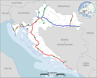
Highways in Croatia are the main transport network in Croatia. The Croatian classification includes several classes of highways:

<span class="mw-page-title-main">Otoyol 30</span>

Otoyol 30, also known as the Izmir Beltway and abbreviated as the O-30, is a 60.2 km (37.4 mi) long motorway that runs around the Gulf of Izmir from Balçova to Menemen. The motorway acts as a bypass for through-traffic around the city and connects to four other motorways; O-5, O-31, O-32 and O-33. For most of its route, the O-30 runs along the perimeter of Izmir, but enters urbanized areas in Balçova, Bornova, Karşıyaka and Çiğli. The entire motorway has six lanes and is a part of the E87 and E881.

<span class="mw-page-title-main">Otoyol 2</span> Highway in Turkey

Otoyol 2, abbreviated as O-2, locally referred to as 2. Çevreyolu, is a motorway in Istanbul, Turkey that forms the outer ring road of the city connecting European and Asian parts via the Fatih Sultan Mehmet Bridge.

<span class="mw-page-title-main">Otoyol 4</span> Highway in Turkey

Otoyol 4, named Anatolian Motorway and abbreviated as O-4, is a toll motorway connecting the northwestern Marmara Region to the Central Anatolia Region in Turkey. It runs parallel to the D.100 for more than half of its length and then parallels the D750 for most of the eastern half. The O-4 is a major expressway in Turkey as it connects eastern Istanbul and the heavily urbanized northeastern shore of the Sea of Marmara to the nation's capital, Ankara. The O-4 also makes up part of the International E-road network E80 and E89 as well as the AH-1 of the Asian Highway Network.

<span class="mw-page-title-main">General Directorate of Highways (Turkey)</span> Turkish state agency in charge of public roads

The General Directorate Of Highways (KGM) is a state agency in charge of the construction and maintenance of all public roadways outside of cities and towns in Turkey. It was established on 1 March 1950, following the acceptance of the International Highways Act in 1949. The agency is a sub unit of the Ministry of Transport and Infrastructure.

<span class="mw-page-title-main">Otoyol 50</span> Highway in Turkey

Otoyol 50, abbreviated as O-50, aka Adana Çevreyolu, was the former designation for the 22 km (14 mi) long motorway passing through the city of Adana, Turkey. In the 2014 the KGM resigned the section of motorway west of the Seyhan River as the O-51 and the section west of the Seyhan River as O-52. Thus extending the O-52 and O-51 into central Adana.

<span class="mw-page-title-main">Otoyol 52</span> Highway in Turkey

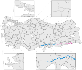
Otoyol 52, abbreviated as O-52, a.k.a.Adana-Şanlıurfa Otoyolu, is a toll motorway in the regions of Mediterranean and Southeastern Anatolia in Turkey, connecting the cities Adana and Şanlıurfa. The motorway is part of European route E90 and Asian Highway 84. The O-52 starts from the eastern terminus of The O-51, runs eastward through Osmaniye, Gaziantep and terminates east of Şanlıurfa. The O-52 is currently the second longest Motorway in Turkey being only 5 km shorter than the O-4.

<span class="mw-page-title-main">Korutepe Tunnel</span>

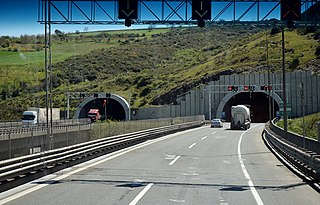
The Korutepe Tunnel, is a motorway tunnel constructed on the Istanbul–Ankara motorway O-4 E80 in Kocaeli Province, northwestern Turkey.

<span class="mw-page-title-main">Bayraklı Tunnels</span>

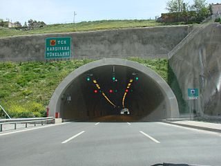
Bayraklı Tunnels, formerly Karşıyaka Tunnels, are two motorway tunnels in series located on the İzmir's northern beltway, motorway O-30 E87, in Bayraklı district between Karşıyaka and Bornova of Izmir Province, western Turkey.

The Taşoluk Tunnel, is a motorway tunnel constructed on the Adana–Şanlıurfa motorway O-52 E90 AH84 in Osmaniye Province, southern Turkey.

The İğdir Tunnel, is a motorway tunnel constructed on the Bursa–Sivrihisar motorway O-22 E90 in Bursa Province, northwestern Turkey. It was opened to the traffic in 2005.

<span class="mw-page-title-main">Otoyol</span> National network of controlled-access highways in the Republic of Turkey

The Otoyol is the national network of controlled-access highways in Turkey. The term Otoyol translates to motorway while the literal meaning is auto-route. The Otoyol was first opened in 1973.

The State Highways of the Republic of Turkey, abbreviated as T.C.K. are an integrated network of highways and roads in Turkey, consisting of a numbered grid spanning across the country. They are more commonly called State roads and are the primary road network in Turkey. The network is mostly maintained by the General Directorate of Highways (KGM), except for within large cities where the respective city municipality assumes responsibility.

The Seyhan Viaduct is a 470-metre-long (1,540 ft) box-girder bridge that carries the O-51 motorway across the Seyhan River in Adana, Turkey. The bridge is the northernmost crossing of the river before the Seyhan Dam, just upstream.

<span class="mw-page-title-main">Otoyol 7</span> Toll motorway in Istanbul

The Otoyol 7, or Kuzey Marmara Otoyolu, is a toll motorway in Turkey that bypasses Istanbul to the north. The motorway is 243 km in length between the Kınalı junction and the Akyazı junction, and is 8 lanes wide.

References

  1. "YILLAR İTİBARIYLA YAPIMI TAMAMLANMIŞ OTOYOLLAR [Motorway completed by years] (2023)" (PDF). kgm.gov.tr. Karayolları Genel Müdürlüğü (KGM). Retrieved 2024-01-05.