
Transport in Jersey is primarily through the motor vehicle. The island, which is the largest of the Channel Islands has 124,737 registered vehicles (2016). The island is committed to combatting climate change, having declared a climate emergency, and policy is focused on reducing dependence on the car. The island has a cycle network and bus service. The primary modes of transport for leaving the island are by air or sea.
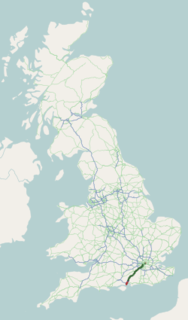
The A3, known as the Portsmouth Road or London Road in sections, is a major road connecting the City of London and Portsmouth passing close to Kingston upon Thames, Guildford, Haslemere and Petersfield. For much of its 67-mile (108 km) length, it is classified as a trunk road and therefore managed by Highways England. Almost all of the road has been built to dual carriageway standards or wider. Apart from bypass sections in London, the road travels in a southwest direction and, after Liss, south-southwest.
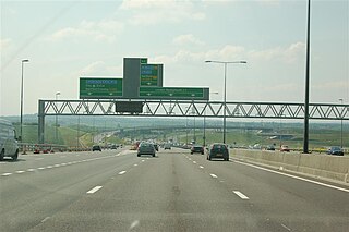
The A2 is a major road in south-east England, connecting London with the English Channel port of Dover in Kent. This route has always been of importance as a connection between London and sea trade routes to Continental Europe. It was originally known as the Dover Road. The M2 motorway has replaced part of the A2 as the strategic route.

St. Helier is one of the twelve parishes of Jersey, the largest of the Channel Islands in the English Channel. St. Helier has a population of 35,822 – over one-third of the total population of Jersey – and is the capital of the island.
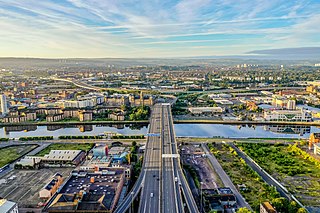
The city of Glasgow, Scotland has a transport system encompassing air, rail, road, and an underground rail line. Prior to 1962, the city was also served by trams. Commuters travelling into Glasgow from the neighbouring local authorities of North and South Lanarkshire, Renfrewshire, East Renfrewshire, and East and West Dunbartonshire have a major influence on travel patterns, with tens of thousands of residents commuting into the city each day. The most popular mode of transport in the city is the car, used by two thirds of people for journeys around the city.

St. Saviour is a parish of Jersey in the Channel Islands. It is located directly east of St. Helier. It has a population of 13,580. It has a land surface area of 3.6 square miles and has a very small coastline at Le Dicq.

St. Clement is one of the twelve parishes of Jersey in the Channel Islands. Its parish hall is around 3.6 kilometres (2.2 mi) south-east of St. Helier. The parish has a population of 9,221 and is the second most densely populated.

Grouville is one of the twelve parishes of Jersey in the Channel Islands. The parish is around 3.9 kilometres (2.4 mi) east of St Helier. The parish covers a surface area of 4,354 vergées (7.8 km²). The parish includes the south-east portion of the main island of the Bailiwick of Jersey, as well as the Minquiers islets several miles to the south, and is dominated by the broad sweep of the Royal Bay of Grouville. It borders St. Clement, St. Saviour and St. Martin.

St. Martin is one of the twelve parishes of Jersey in the Channel Islands. It is 5.5 kilometres (3.4 mi) north-east of St Helier. It has a population of 3,763. The parish covers 10.3 km2 (4.0 sq mi).

Gorey is a village in the parishes of St Martin and Grouville on the east coast of Jersey. The harbour is one of the three main harbours of the island, and is located in St Martin. The main centre of the village is located at Gorey Pier near Mont Orgeuil Castle, a 13th century fortification, in St Martin, while there is a small community with a few shops. The church in the village is known as Gouray Church.

The A329 is an east–west road in Southern England that runs from Wentworth in Surrey to Thame in Oxfordshire. The A329 starts at the A30 in Surrey and passes through Ascot, Bracknell, Wokingham, Earley, Reading, Purley, Pangbourne, Lower Basildon, Streatley, Moulsford and Wallingford. It connects to junction 7 of the M40 before finally ending at a junction with the A418 at Thame.

The A226 road travels in a west–east direction in southeast London and north Kent, from Crayford in the London Borough of Bexley, through Dartford, Gravesend to Strood. It is about 15.7 miles in length. Before road numbering began in the United Kingdom, the road was part of the major route between London and Dover, the road taken by all traffic heading for mainland Europe. When the Ministry of Transport published its first list of road numbers, however, the building of the A2 had already begun; and the earliest map shows the projected route of that latter road; the previous road being relegated to what is now the A226.

The Jersey Eastern Railway was a standard gauge railway that began operations on 6 August 1873 in Jersey. The line closed on 21 June 1929. It is not to be confused with the Jersey Railway.
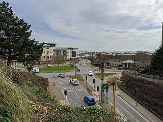
Epping Road is a 10-kilometre-long (6.2 mi) arterial road located on the North Shore of Sydney, New South Wales, Australia. Epping Road is a major route linking the lower North Shore and Sydney central business district to the north western suburbs of the upper North Shore and Hills District of metropolitan Sydney, being a major access road to the commercial, industrial and university areas of North Ryde and Macquarie Park.

Jersey Heritage is an independent trust in Jersey which is responsible for the island's major historic sites, museums, and public archives. It holds collections of artefacts, works of art, documents, specimens, and information relating to Jersey's history, culture, and environment.

King Street, also known as Rue de Derrière, is one of the two parts of the high street of Saint Helier in Jersey.

The A1 road in Jersey links St. Helier with St. Aubin in the parish of St Brelade.

Victoria Avenue is a major road in Jersey, connecting the capital St Helier to Bel Royal in St Lawrence, also providing access to the western part of the A1 for non-bus traffic, due to a bus gate that prevents traffic from the A1 continuing on the A1.

St Helier railway station was the terminus of the Jersey Eastern Railway (JER) in Saint Helier, the capital of Jersey in the Channel Islands. Opened in 1874, it was situated in a railway cutting at the base of Mont de la Ville below Fort Regent. The station was referred to as St. Helier to distinguish it from another railway terminus opened by the Jersey Railway in 1873 at the Weighbridge in St Helier. The station was in passenger operation until the line closed in 1929. Today the site is occupied by the Snow Hill car park.
The A17 road, more commonly known as La Route du Fort, is a road in Jersey, Channel Islands.

