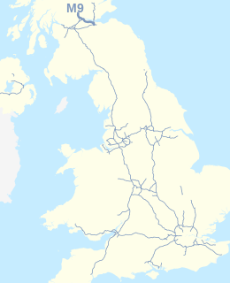
The M9 is a major motorway in Scotland. It runs from the outskirts of Edinburgh, bypassing the towns of Linlithgow, Falkirk, Grangemouth and Stirling to end at Dunblane.

The Edinburgh City Bypass, designated as A720, is one of the most important trunk roads in Scotland. Circling around the south of Edinburgh, as the equivalent of a ring road for the coastal city, it links together the A1 towards north-east England, the A702 towards north-west England, the M8 through the Central Belt towards Glasgow, the A7 through south-east Scotland and north-west England as well as the A8 leading to the M9 for Stirling and the Queensferry Crossing.
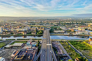
The city of Glasgow, Scotland has a transport system encompassing air, rail, road, and an underground rail line. Prior to 1962, the city was also served by trams. Commuters travelling into Glasgow from the neighbouring local authorities of North and South Lanarkshire, Renfrewshire, East Renfrewshire, and East and West Dunbartonshire have a major influence on travel patterns, with tens of thousands of residents commuting into the city each day. The most popular mode of transport in the city is the car, used by two thirds of people for journeys around the city.
Bruntsfield is a largely residential area around Bruntsfield Place in Southern Edinburgh, Scotland. In feudal times, it fell within the barony of Colinton.
Morningside is a district and former village in the south of Edinburgh, Scotland. It lies alongside the main arterial Morningside Road, part of an ancient route from Edinburgh to the south west of Scotland. The original village served several farms and estates in the area. In the 19th century, it developed as a residential suburb, its growth being stimulated by the arrival of a railway service and other transport improvements.

The A702 is a major road in Scotland, that runs from Edinburgh to St. John's Town of Dalry in Dumfries and Galloway. It is the last section of the route from London via the West Midlands and North West England to Edinburgh, which follows the M1, M6, A74(M) and finally the A702.

Piershill is a suburb of north east Edinburgh, Scotland, in the shadow of Arthur's Seat. It is mainly residential, with local amenities including a large Morrisons supermarket and filling station, bank, public library, optician, pharmacy, several takeaway restaurants and specialist retailers along with public houses.
King's Highway 9, commonly referred to as Highway 9, is a provincially maintained highway in the Canadian province of Ontario. Highway 9 has been divided into two segments since January 1, 1998, when the segment between Harriston and Orangeville was downloaded to the various counties in which it resided. The western segment of the highway begins at Highway 21 in Kincardine, near the shores of Lake Huron. It travels 73 km (45 mi) to the junction of Highway 23 and Highway 89 in Harriston. The central segment is now known as Wellington County Road 109 and Dufferin County Road 109. At Highway 10 in Orangeville, Highway 9 resumes and travels east to Highway 400. The highway once continued east to Yonge Street in Newmarket, but is now known as York Regional Road 31.

Lothian Buses is the largest municipal bus company in the United Kingdom. The City of Edinburgh Council owns 91%, Midlothian Council 5%, East Lothian Council 3% and West Lothian Council 1%.

Edinburgh is a major transport hub in east central Scotland and is at the centre of a multi-modal transport network with road, rail and air communications connecting the city with the rest of Scotland and internationally.

Granton is a district in the north of Edinburgh, Scotland. Granton forms part of Edinburgh's waterfront along the Firth of Forth and is, historically, an industrial area having a large harbour. Granton is part of Edinburgh's large scale waterfront regeneration programme.
Tollcross is a major road junction to the south west of the city centre of Edinburgh, Scotland which gives its name to the surrounding area.

Fountainbridge is an area of Edinburgh, Scotland, a short distance west of the city centre, adjoining Tollcross with East Fountainbridge and West Port to the east, Polwarth to the west and south, Dalry and Haymarket to the north and Gorgie and North Merchiston to the west. The main streets through the area are Fountainbridge and Dundee Street.
The Edinburgh Suburban and Southside Junction Railway was a railway company that built an east-west railway on the southern margin of Edinburgh, Scotland, primarily to facilitate the operation of heavy goods and mineral traffic across the city. The line opened in 1884. Although its route was rural at the time, suburban development quickly caught up and passenger carryings on the line were buoyant; the passenger service operated on a circular basis through Edinburgh Waverley railway station.

Kirknewton is a village formerly in the county of Midlothian and, since 1975, in West Lothian, Scotland. The population of the Kirknewton Community Council district is 2200, which includes the village and surrounding areas. It lies south of the A71 from Edinburgh to Livingston, and north of the A70, the high-level road that runs along the north side of the Pentland Hills from Edinburgh to Carnwath and Lanark. Much of the village stands back from the B7031, which links the two main "A" roads. To the south-east of the village is Morton.
The Christchurch Southern Motorway is the main southern route into and out of Christchurch, New Zealand. The motorway forms part of State Highway 1 and State Highway 76.

The Meadows is a large public park in Edinburgh, Scotland, to the south of the city centre.

The West End of Edinburgh, Scotland, forms a large part of the city centre. The West End boasts several of the city's hotels, restaurants, independent shops, offices and arts venues, including the Edinburgh Filmhouse, Edinburgh International Conference Centre and the Caledonian Hotel. The area also hosts art festivals and crafts fairs.

