Related Research Articles

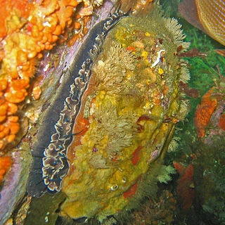
Abalone is a common name for any of a group of small to very large marine gastropod molluscs in the family Haliotidae. Other common names are ear shells, sea ears, and, rarely, muttonfish or muttonshells in parts of Australia, ormer in the UK, perlemoen in South Africa, and pāua in New Zealand. Abalones are marine snails. Their taxonomy puts them in the family Haliotidae, which contains only one genus, Haliotis, which once contained six subgenera. These subgenera have become alternative representations of Haliotis. The number of species recognized worldwide ranges between 30 and 130 with over 230 species-level taxa described. The most comprehensive treatment of the family considers 56 species valid, with 18 additional subspecies. The shells of abalones have a low, open spiral structure, and are characterized by several open respiratory pores in a row near the shell's outer edge. The thick inner layer of the shell is composed of nacre (mother-of-pearl), which in many species is highly iridescent, giving rise to a range of strong, changeable colors which make the shells attractive to humans as decorative objects, jewelry, and as a source of colorful mother-of-pearl.
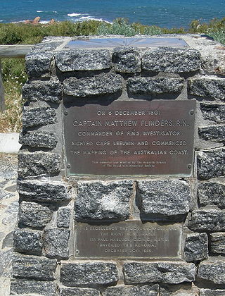
Flinders Bay is a bay that is immediately south of the townsite of Augusta, and close to the mouth of the Blackwood River.
Muscovite Lakes Provincial Park is a provincial park in British Columbia, Canada. It is located on the western shore of Lake Williston, about 125 kilometres (78 mi) north of Mackenzie.
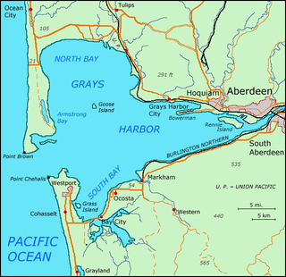
Grays Harbor is an estuarine bay located 45 miles (72 km) north of the mouth of the Columbia River, on the southwest Pacific coast of Washington state, in the United States. It is a ria, which formed at the end of the last ice age, when sea levels flooded the Chehalis River. The bay is 17 miles (27 km) long and 12 miles (19 km) wide. The Chehalis River flows into its eastern end, where the city of Aberdeen stands at that river's mouth, on its north bank, with the somewhat smaller city of Hoquiam immediately to its northwest, along the bayshore. Besides the Chehalis, many lesser rivers and streams flow into Grays Harbor, such as Hoquiam River and Humptulips River. A pair of low peninsulas separate it from the Pacific Ocean, except for an opening about two miles (3 km) in width. The northern peninsula, which is largely covered by the community of Ocean Shores, ends in Point Brown. Facing that across the bay-mouth is Point Chehalis, at the end of the southern peninsula upon which stands the town of Westport.

Tuscarora Mountain is a mountain ridge of the Appalachian Mountains in the Ridge and Valley province in central Pennsylvania. It reaches its highest point on Big Mountain (Pennsylvania) at 2,458 feet (749 m) above sea level. The mountain is named after the Tuscarora people.
Haliotis rufescens is a species of very large edible sea snail in the family Haliotidae, the abalones, ormer shells or paua. It is distributed from British Columbia, Canada, to Baja California, Mexico. It is most common in the southern half of its range.

Division Street is a one-way street in the Two Bridges neighborhood of Lower Manhattan in New York City. It carries westbound traffic from the intersection of Canal Street and Ludlow Street westward to Bowery.

The pink abalone, scientific name Haliotis corrugata, is a species of large edible sea snail, a marine gastropod mollusk in the family Haliotidae, the abalones.

The Bear River Band of the Rohnerville Rancheria is a federally recognized tribe of Mattole, Bear River and Wiyot people in Humboldt County, California.

Centerville is a former settlement in Humboldt County, California. It was located 4.5 miles (7 km) west of Ferndale, on the Pacific Ocean at an elevation of 13 feet.
Sea Lion Cove State Marine Conservation Area (SMCA) is a marine protected area that lies onshore, just south of Point Arena in Mendocino County on California’s north central coast. The marine protected area covers 0.22 square miles. Sea Lion Cove SMCA prohibits the commercial and recreational take of invertebrates, algae and other plants, but allows the take of all other species.

Del Mar Landing State Marine Reserve (SMR) is a marine protected area that lies onshore, about 2 miles (3 km) south of the town of Gualala and 3.5 miles north of Sea Ranch in Sonoma County on California’s north central coast. The marine protected area covers 0.22 square miles (0.57 km2). Del Mar Landing SMR prohibits the taking of all living marine resources.

Stewarts Point State Marine Reserve (SMR) and Stewarts Point State Marine Conservation Area (SMCA) are two adjoining marine protected areas that extend offshore from about a mile south of Black Point to Fisk Mill Cove, in Sonoma County on California’s north central coast. The marine protected areas cover 25.22 square miles. Stewarts Point SMR prohibits the take of all living marine resources. Stewarts Point SMCA prohibits the take of all living marine resources, except recreational shore based take of marine aquatic plants, marine invertebrates, finfish by hook and line, surf smelt by beach net, and species authorized by Title 14 Section 28.80 by hand-held dip net.

Duxbury Reef State Marine Conservation Area (SMCA) is a marine protected area located about 1 mile (2 km) west of Bolinas in Marin County on California’s north central coast. This marine protected area covers 0.66 square miles (1.7 km2). Duxbury Reef SMCA prohibits the take of all living marine resources, except the recreational take of finfish from shore only and the recreational take of abalone.
Salt Point State Marine Conservation Area (SMCA) is a marine protected area that lies onshore from Fisk Mill Cove and south along Salt Point State Park in Sonoma County on California’s north central coast. The marine protected area covers 3.12 square miles. Salt Point SMCA prohibits the take of all living marine resources, except the recreational take of abalone and finfish.

Haliotis fulgens, commonly called the green abalone, is a species of large sea snail, a marine gastropod mollusc in the family Haliotidae, the abalones. The shell of this species is usually brown, and is marked with many low, flat-topped ribs which run parallel to the five to seven open respiratory pores that are elevated above the shell's surface. The inside of the shell is an iridescent blue and green.
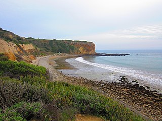
Abalone Cove State Marine Conservation Area (SMCA) and Point Vicente State Marine Reserve (SMR) are two adjoining marine protected areas that extend offshore in Los Angeles County on California's south coast. The two marine protected areas cover 19.87 sq mi (51.5 km2). The marine protected areas protect natural habitats and marine life by protecting or limiting removal of wildlife from within their boundaries. Point Vicente SMR, prohibits all take of living marine resources. Abalone Cove SMCA, prohibits take of all living marine resources, except recreational take of pelagic finfish, including Pacific bonito and white seabass by spearfishing, market squid by hand-held dip net, commercial take of coastal pelagic species and Pacific bonito by round haul net, and swordfish by harpoon.
Aurivirus is a genus of viruses in the order Herpesvirales, and one of only two genera the family Malacoherpesviridae. Haliotid molluscs serve as natural hosts. There is only one species described in this genus, Haliotid herpesvirus 1 (AbHV-1), commonly known as abalone herpesvirus. A disease associated with this virus is acute ganglioneuritis.
Washington Maritime National Wildlife Refuge Complex is an administrative grouping of six National Wildlife Refuges in Washington, managed by the United States Fish and Wildlife Service. It includes:
References

| | This Humboldt County, California–related article is a stub. You can help Wikipedia by expanding it. |