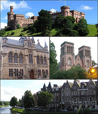
Inverness is one of the eight cities of Scotland and is located in the Scottish Highlands, having been granted city status in 2000. It is the administrative centre for The Highland Council and is regarded as the capital of the Highlands. Historically it served as the county town of the county of Inverness-shire. Inverness lies near two important battle sites: the 11th-century battle of Blàr nam Fèinne against Norway which took place on the Aird, and the 18th century Battle of Culloden which took place on Culloden Moor. It is the northernmost city in the United Kingdom and lies within the Great Glen at its northeastern extremity where the River Ness enters the Beauly Firth. At the latest, a settlement was established by the 6th century with the first royal charter being granted by Dabíd mac Maíl Choluim in the 12th century. Inverness and Inverness-shire are closely linked to various influential clans, including Clan Mackintosh, Clan Fraser and Clan MacKenzie.

Crail ; Scottish Gaelic: Cathair Aile) is a former royal burgh, parish and community council area in the East Neuk of Fife, Scotland.

Inverurie is a town in Aberdeenshire, Scotland at the confluence of the rivers Ury and Don, about 16 miles (26 km) north-west of Aberdeen.

Banffshire is a historic county, registration county and lieutenancy area of Scotland. The county town is Banff, although the largest settlement is Buckie to the west. It borders the Moray Firth to the north, Morayshire and Inverness-shire to the west, and Aberdeenshire to the east and south.

Pittenweem ( ) is a fishing village and civil parish in Fife, on the east coast of Scotland. At the 2001 census, it had a population of 1,747.

Aberlour is a village in Moray, Scotland, 12 miles (20 km) south of Elgin on the road to Grantown. The Lour burn is a tributary of the River Spey, and it and the surrounding parish are both named Aberlour, but the name is more commonly used in reference to the village which straddles the stream and flanks the Spey – although the full name of the village is Charlestown of Aberlour.

Abernethy is a village in Perth and Kinross, Scotland, situated 8 miles (13 km) south-east of Perth.
Newburgh is a royal burgh and parish in Fife, Scotland, at the south shore of the Firth of Tay. The town has a population of 2,171, which constitutes a 10% increase since 1901 when the population was counted at 1,904 persons.

Turriff is a town and civil parish in Aberdeenshire in Scotland. It lies on the River Deveron, about 166 feet (51 m) above sea level, and has a population of 5,708. In everyday speech it is often referred to by its Scots name Turra, which is derived from the Scottish Gaelic pronunciation.

Dollar is a small town with a population of 2,800 people in Clackmannanshire, Scotland. It is 12 miles east of Stirling.

Insch is a village in the Garioch, Aberdeenshire, Scotland. It is located approximately 28 miles (45 km) from the city of Aberdeen.

Rosemarkie is a village on the south coast of the Black Isle peninsula in Ross-shire, northern Scotland.
Monifieth is a town and former police burgh in the council area of Angus, Scotland. It is situated on the north bank of the Firth of Tay on the east coast. In 2016, the population of Monifieth was estimated at 8,110, making it the fifth largest town in Angus.

Dallas is a small rural village in Moray, Scotland. It is located 12 miles (19 km) south west of Elgin just off the B9010 road. It has a population of between 150 and 200.
Kincardine or Kincardine-on-Forth is a small town on the north shore of the Firth of Forth, in Fife, Scotland. The town was given the status of a burgh of barony in 1663. It was at one time a reasonably prosperous minor port. The townscape retains many good examples of Scottish vernacular buildings from the 17th, 18th and early 19th centuries, although it was greatly altered during the construction of Kincardine Bridge in 1932–1936. It is in the civil parish of Tulliallan.

Meigle is a village in Strathmore, Scotland. It lies in the council area of Perth and Kinross in the Coupar Angus and Meigle ward. It lies on the A94 road between Perth and Forfar.The A94 used to be the main route between Aberdeen and Perth. Other smaller settlements nearby are Balkeerie, Kirkinch and Kinloch. Meigle is accessed from the north and south via the B954 road. In 1971 it had a population of 357.
Abercrombie is a village in Fife, Scotland.

Auchenblae is a village in the Kincardine and Mearns area of Aberdeenshire, formerly in Kincardineshire, Scotland. The village was known for its weavers, a whisky distillery and the annual Paldie's Fair horse market.

Ballingry ; Scots: Ballingry, Bingry, Scottish Gaelic: Baile Iongrach) is a small town in Fife, Scotland. It is near the boundary with Perth and Kinross, north of Lochgelly. It has an estimated population (2016) of 5,940. The once separate villages of Ballingry, Lochore, Crosshill, and Glencraig are now somewhat joined together as the part of the Benarty area. Ballingry, along with its neighbour Lochgelly, is one of Fife's 'regeneration areas' and is classed as in need of regeneration economically and socially.

Rhynie is a village in Aberdeenshire, Scotland. It is on the A97 road, 14 miles (23 km) northwest of Alford.


