Abercrombie, North Dakota

Last updated

Abercrombie, North Dakota
Abercrombie North Dakota.jpg
Broadway in Abercrombie in 2007
ND Richland County Abercrombie.svg
Location of Abercrombie, North Dakota
USA North Dakota location map.svg
Red pog.svg
Abercrombie, North Dakota
Usa edcp location map.svg
Red pog.svg
Abercrombie, North Dakota
North America laea location map.svg
Red pog.svg
Abercrombie, North Dakota
Coordinates: 46°26′50″N96°43′46″W / 46.44722°N 96.72944°W / 46.44722; -96.72944
CountryUnited States
State North Dakota
County Richland
Founded1884
Area
[1]
  Total0.32 sq mi (0.84 km2)
  Land0.32 sq mi (0.84 km2)
  Water0.00 sq mi (0.00 km2)
Elevation
938 ft (286 m)
Population
 (2020)
  Total244
  Density753.09/sq mi (290.83/km2)
Time zone UTC-6 (CST)
  Summer (DST) UTC-5 (CDT)
ZIP code
58001
Area code 701
FIPS code 38-00100
GNIS feature ID1027647 [2]

Abercrombie is a city in Richland County, North Dakota, United States. The population was 244 at the 2020 census. [3] Abercrombie was founded in 1884.

Contents

History

Abercrombie was founded in 1884. It was named after Fort Abercrombie, a local military installation adjacent to the city. [4] This means the city indirectly received its name from Lieutenant Colonel Abercrombie, first commanding officer of the fort. The city is part of the military reservation and is located on section 4, 134–48. [5]

Abercrombie did not come into being until 1884, when Fargo and Southern Railroad was built through the Red River Valley along the Red River. Then directly west of the old fort, the town of Abercrombie was started. [5]

Geography

Abercrombie is located at 46°26′50″N96°43′46″W / 46.44722°N 96.72944°W / 46.44722; -96.72944 (46.447182, -96.729487). [6]

According to the United States Census Bureau, the city has a total area of 0.61 square miles (1.58 km2), all land. [7]

Demographics

Historical population
CensusPop.Note
1910 299
1920 266−11.0%
1930 242−9.0%
1940 215−11.2%
1950 24413.5%
1960 2440.0%
1970 2627.4%
1980 260−0.8%
1990 252−3.1%
2000 29617.5%
2010 263−11.1%
2020 244−7.2%
2021 (est.)255 [8] 4.5%
U.S. Decennial Census [9]
2020 Census [3]

Abercrombie is part of the Wahpeton, ND MN Micropolitan Statistical Area.

2010 census

As of the census of 2010, there were 263 people, 104 households, and 68 families residing in the city. The population density was 431.1 inhabitants per square mile (166.4/km2). There were 121 housing units at an average density of 198.4 per square mile (76.6/km2). The racial makeup of the city was 98.5% White, 0.4% African American, 0.8% Native American, and 0.4% from two or more races. Hispanic or Latino of any race were 0.4% of the population.

There were 104 households, of which 37.5% had children under the age of 18 living with them, 52.9% were married couples living together, 8.7% had a female householder with no husband present, 3.8% had a male householder with no wife present, and 34.6% were non-families. 31.7% of all households were made up of individuals, and 16.4% had someone living alone who was 65 years of age or older. The average household size was 2.53 and the average family size was 3.15.

The median age in the city was 35.8 years. 30.4% of residents were under the age of 18; 5.4% were between the ages of 18 and 24; 25.9% were from 25 to 44; 25.8% were from 45 to 64; and 12.5% were 65 years of age or older. The gender makeup of the city was 48.7% male and 51.3% female.

2000 census

As of the census of 2000, there were 296 people, 118 households, and 73 families residing in the city. The population density was 482.6 inhabitants per square mile (186.3/km2). There were 138 housing units at an average density of 225.0 per square mile (86.9/km2). The racial makeup of the city was 96.62% White, 1.35% Native American, 0.34% Asian, and 1.69% from two or more races.

The top 6 ancestry groups in the city are Norwegian (54.4%), German (41.9%), Irish (12.8%), Swedish (12.2%), English (7.4%), Czech (6.8%).

There were 118 households, out of which 35.6% had children under the age of 18 living with them, 54.2% were married couples living together, 5.1% had a female householder with no husband present, and 38.1% were non-families. 33.1% of all households were made up of individuals, and 9.3% had someone living alone who was 65 years of age or older. The average household size was 2.51 and the average family size was 3.27.

In the city, the population was spread out, with 32.1% under the age of 18, 6.4% from 18 to 24, 31.8% from 25 to 44, 18.9% from 45 to 64, and 10.8% who were 65 years of age or older. The median age was 33 years. For every 100 females, there were 124.2 males. For every 100 females age 18 and over, there were 113.8 males.

The median income for a household in the city was $34,167, and the median income for a family was $37,125. Males had a median income of $30,000 versus $17,321 for females. The per capita income for the city was $13,911. About 8.8% of families and 13.8% of the population were below the poverty line, including 19.5% of those under the age of eighteen and none of those 65 or over.

Economy

The economy of Abercrombie is surrounded by agriculture. While agriculture does play the dominant role in the southern Red River Valley, the city of Abercrombie provides employment in sectors such as education, telecommunication, and manufacturing.

Largest Employers

Culture

Many of the settlers who came from Norway, Sweden and Denmark in the late 1860s and early 1870s came first to Wisconsin and southern Minnesota to work in the Lumber mills. While there, they heard much about the Red River Valley and its fertility and great possibility. At this time a Mr. Strandvold was writing articles geared towards appealing to young Norsemen with the intention of drawing them to the Valley. [5]

Education

The city of Abercrombie is served by the Richland 44 School District, which contains 2 schools:

Elementary School (Preschool-6)
Junior/Senior High School (7-12)

Climate

This climatic region is typified by large seasonal temperature differences, with warm to hot (and often humid) summers and cold (sometimes severely cold) winters. According to the Köppen Climate Classification system, Abercrombie has a humid continental climate, abbreviated "Dfb" on climate maps. [11]

Related Research Articles

<span class="mw-page-title-main">Richland County, Ohio</span> County in Ohio, United States

Richland County is a county located in the U.S. state of Ohio. As of the 2020 census, the population was 124,936. Its county seat is Mansfield. The county was created in 1808 and later organized in 1813. It is named for the fertile soil found there.

<span class="mw-page-title-main">Oakhaven, Arkansas</span> Town in Arkansas, United States

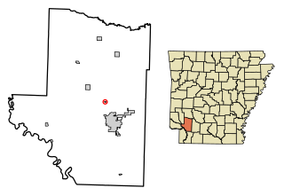
Oakhaven is a town in Hempstead County, Arkansas, United States. The population was 63 at the 2010 census. It is part of the Hope Micropolitan Statistical Area.

<span class="mw-page-title-main">Craig, Iowa</span> City in Iowa, United States

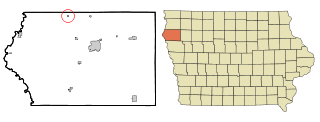
Craig is a city in Plymouth County, Iowa, United States. The population was 79 at the 2020 census.

<span class="mw-page-title-main">Spivey, Kansas</span> City in Kingman County, Kansas

Spivey is a city in Kingman County, Kansas, United States. As of the 2020 census, the population of the city was 61.

<span class="mw-page-title-main">Richland, Michigan</span> Village in Michigan, United States

Richland is a village in Kalamazoo County in the U.S. state of Michigan. The population was 751 at the 2010 census, up from 593 at the 2000 census.

<span class="mw-page-title-main">New Richland, Minnesota</span> City in Minnesota, United States

New Richland is a city in Waseca County, Minnesota, United States. The city was founded in 1877. The population was 1,203 at the 2010 census.

<span class="mw-page-title-main">Strandquist, Minnesota</span> City in Minnesota, United States

Strandquist is a city in Lincoln Township of Marshall County, Minnesota, United States. The population was 70 at the 2020 census.

<span class="mw-page-title-main">Buffalo, North Dakota</span> City in North Dakota, United States

Buffalo is a city in Cass County, North Dakota, United States. The population was 195 at the 2020 census. Buffalo was founded in 1878.

<span class="mw-page-title-main">Tolley, North Dakota</span> City in North Dakota, United States

Tolley is a city in Renville County, North Dakota, United States. The population was 41 at the 2020 census. It is part of the Minot Micropolitan Statistical Area. Tolley was founded by Eli Crane Tolley in 1905. Mr. Tolley was born in Darlington, Wisconsin in 1860 to parents William Tolley and Frances G. (Crane) Tolley. The current mayor of Tolley is Rick Tohm.

<span class="mw-page-title-main">Colfax, North Dakota</span> City in North Dakota, United States

Colfax is a city in Richland County, North Dakota, United States. The population was 172 at the 2020 census. Colfax was founded in 1881. It is part of the Wahpeton, ND–MN Micropolitan Statistical Area. In the mid-1960s it billed itself as the "smallest town in the U.S. with a public swimming pool".

<span class="mw-page-title-main">Dwight, North Dakota</span> City in North Dakota, United States

Dwight is a city in Richland County, North Dakota, United States. The population was 80 at the 2020 census. Dwight was founded in 1881. It is part of the Wahpeton, ND–MN Micropolitan Statistical Area.

<span class="mw-page-title-main">Fairmount, North Dakota</span> City in Richland County, North Dakota, United States

Fairmount is a city in Richland County, North Dakota, United States. The population was 343 at the 2020 census. Fairmount was founded in 1884. It is part of the Wahpeton, ND–MN Micropolitan Statistical Area.

<span class="mw-page-title-main">Hankinson, North Dakota</span> City in North Dakota, United States

Hankinson is a city in Richland County, North Dakota, United States. The population was 921 at the 2020 census. Hankinson was founded in 1886. It is part of the Wahpeton, ND–MN Micropolitan Statistical Area.

<span class="mw-page-title-main">Lidgerwood, North Dakota</span> City in North Dakota, United States

Lidgerwood is a city in Richland County, North Dakota, United States. The population was 600 at the 2020 census. Lidgerwood was founded in 1886. It is part of the Wahpeton, ND–MN Micropolitan Statistical Area.

<span class="mw-page-title-main">Mantador, North Dakota</span> City in North Dakota, United States

Mantador is a city in Richland County, North Dakota, United States. The population was 67 at the 2020 census. Mantador was founded in 1893. It is part of the Wahpeton, ND-MN Micropolitan Statistical Area.

<span class="mw-page-title-main">Walcott, North Dakota</span> City in North Dakota, United States

Walcott is a city in Richland County, North Dakota, United States. The population was 262 at the 2020 census. Walcott was founded in 1880. It is part of the Wahpeton, ND–MN Micropolitan Statistical Area.

<span class="mw-page-title-main">Richland, Oregon</span> City in Oregon, United States

Richland is a city in Baker County, Oregon, United States. The population was 156 at the 2010 census.

<span class="mw-page-title-main">Richland, Texas</span> Town in Texas, United States

Richland is a town in Navarro County, Texas, United States. The population was 264 at the 2010 census.

<span class="mw-page-title-main">Stoutland, Missouri</span> City in Missouri, United States

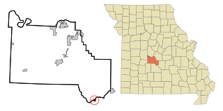
Stoutland is a city in Camden and Laclede counties in the U.S. state of Missouri. The population was 192 at the 2010 census.

<span class="mw-page-title-main">Richland, Iowa</span> City in Iowa, United States

Richland is a city in Keokuk County, Iowa, United States. The population was 542 at the time of the 2020 census.

References

  1. "ArcGIS REST Services Directory". United States Census Bureau. Retrieved September 20, 2022.
  2. "US Board on Geographic Names". United States Geological Survey. October 25, 2007. Retrieved January 31, 2008.
  3. 1 2 "Explore Census Data". American FactFinder. United States Census Bureau . Retrieved July 17, 2022.
  4. Hellmann, Paul T. (May 13, 2013). Historical Gazetteer of the United States. Routledge. p. 831. ISBN   978-1135948597 . Retrieved November 30, 2013.
  5. 1 2 3 Hektner, Vernon (1977). A History of Richland County. Dallas, Texas: Taylor Publishing Company. p. 6.
  6. "US Gazetteer files: 2010, 2000, and 1990". United States Census Bureau. February 12, 2011. Retrieved April 23, 2011.
  7. "US Gazetteer files 2010". United States Census Bureau. Archived from the original on January 12, 2012. Retrieved June 14, 2012.
  8. "City and Town Population Totals: 2020-2021". United States Census Bureau. July 17, 2022. Retrieved July 17, 2022.
  9. United States Census Bureau. "Census of Population and Housing" . Retrieved October 31, 2013.
  10. "Schools in Richland 44 School District - Colfax, ND". GreatSchools. Retrieved March 19, 2011.
  11. Climate Summary for Abercrombie, North Dakota