Abergarwed

Last updated

Abergarwed is a village in the Welsh county borough of Neath Port Talbot, south Wales.

Wales Country in northwest Europe, part of the United Kingdom

Wales is a country that is part of the United Kingdom. It is bordered by England to the east, the Irish Sea to the north and west, and the Bristol Channel to the south. It had a population in 2011 of 3,063,456 and has a total area of 20,779 km2 (8,023 sq mi). Wales has over 1,680 miles (2,700 km) of coastline and is largely mountainous with its higher peaks in the north and central areas, including Snowdon, its highest summit. The country lies within the north temperate zone and has a changeable, maritime climate.

County borough is a term introduced in 1889 in the United Kingdom of Great Britain and Ireland, to refer to a borough or a city independent of county council control. They were abolished by the Local Government Act 1972 in England and Wales, but continue in use for lieutenancy and shrievalty in Northern Ireland. In the Republic of Ireland they remain in existence but have been renamed cities under the provisions of the Local Government Act 2001. The Local Government (Wales) Act 1994 re-introduced the term for certain "principal areas" in Wales. Scotland did not have county boroughs but instead counties of cities. These were abolished on 16 May 1975. All four Scottish cities of the time—Aberdeen, Dundee, Edinburgh, and Glasgow—were included in this category. There was an additional category of large burgh in the Scottish system, which were responsible for all services apart from police, education and fire.

Neath Port Talbot county borough and unitary authority areas

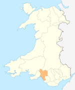
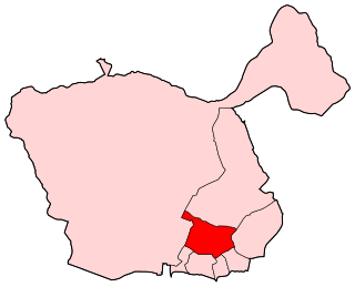
Neath Port Talbot is a county borough and one of the unitary authority areas of Wales. Neath Port Talbot is the eighth most populous local authority area in Wales and the third most populous county borough. The actual population taken at the 2011 census was 139,812. The coastal areas are mainly English-speaking, however there are many Welsh-speaking communities in the Valleys to the north of the borough.

It is located in the Vale of Neath, in the electoral ward of Resolven, near the town of Neath.

The Vale of Neath, one of the South Wales Valleys, encompasses the upper reaches of the River Neath in southwest Wales. In addition to the River Neath, it is traversed by the Neath Canal and the A465 dual carriageway.

Resolven village in Wales

Resolven is a small village and community in Neath Port Talbot county borough, Wales. It is located in the Vale of Neath.

Coordinates: 51°42′29″N3°42′45″W / 51.70806°N 3.71250°W / 51.70806; -3.71250

Geographic coordinate system Coordinate system

A geographic coordinate system is a coordinate system that enables every location on Earth to be specified by a set of numbers, letters or symbols. The coordinates are often chosen such that one of the numbers represents a vertical position and two or three of the numbers represent a horizontal position; alternatively, a geographic position may be expressed in a combined three-dimensional Cartesian vector. A common choice of coordinates is latitude, longitude and elevation. To specify a location on a plane requires a map projection.


Related Research Articles

Lage Zwaluwe Place in North Brabant, Netherlands

Lage Zwaluwe is a village in the municipality Drimmelen, North Brabant, the Netherlands. The Lage Zwaluwe railway station and the Moerdijk bridges lie to the west of the village.

Cirencester Deer Park School is a secondary school with academy status in Cirencester, Gloucestershire, England.

Cirencester College

Cirencester College is a post-16 education provider based at the heart of the South Cotswolds in the town of Cirencester. It is a specialist sixth form serving communities in Gloucestershire, Wiltshire, South Gloucestershire and Oxfordshire, offering the widest choice of subjects in the region and an extensive enrichment programme. The College has a reputation for good quality apprenticeships, bespoke training services and skills for work. It also offers a growing range of adult education courses.

Melincourt Falls waterfall

Melincourt Falls is an 80 feet (24 m) high waterfall on Melin Court Brook, a left-bank tributary of the River Neath / Afon Nedd, located 1-mile (1.6 km) south of Resolven in the county borough of Neath Port Talbot, south Wales. It is formed where the brook plunges over a resistant band of 'Lower Pennant Sandstone' in a 13 acre / 5 hectare nature reserve managed by the Wildlife Trust of South and West Wales. The falls have been drawing visitors for at least two centuries – they are certainly known to have inspired J. M. W. Turner to paint them in 1794. The falls are considered by some to constitute a part of Waterfall Country though the bulk of these falls are a few miles further northeast at the head of the Vale of Neath.

Hanchey Army Heliport

Hanchey Army Heliport is a military heliport serving Fort Rucker in Dale County, Alabama, United States. Owned by the United States Army, it is located 6 NM (11 km) south of the city of Ozark.

Baglan (electoral ward) human settlement in United Kingdom

The Baglan electoral ward includes the communities of Baglan and Baglan Bay, in Neath Port Talbot county borough, Wales. Baglan falls within the parliamentary constituency of Aberavon.

Trebanos is an electoral ward of Neath Port Talbot county borough, Wales, part of the Pontardawe community.

Resolven is and electoral ward of Neath Port Talbot county borough, Wales. Resolven is made up of the parishes of Resolven and Clyne and Melincourt.

Abercrave railway station

Abercrave railway station served the village of Abercraf in the traditional county of Glamorganshire, Wales. Opened in 1869 by the Swansea Vale and Neath and Brecon Junction Railway, it was eventually absorbed by the Great Western Railway which closed it to passengers in 1932 although the line through the station remained open for freight for some time after that.

Rokitowiec Village in Łódź Voivodeship, Poland

Rokitowiec is a village in the administrative district of Gmina Burzenin, within Sieradz County, Łódź Voivodeship, in central Poland. It lies approximately 10 kilometres (6 mi) south-west of Burzenin, 21 km (13 mi) south of Sieradz, and 67 km (42 mi) south-west of the regional capital Łódź.

Aaron Cove is the name of a bay and a community in the Eagle River district in the province of Newfoundland and Labrador, Canada.

Green Valley Acres, California Unincorporated community in California, United States

Green Valley Acres is an unincorporated community in El Dorado County, California. It lies at an elevation of 679 feet.

Ertlerger, California Former settlement in California, United States

Ertlerger is a former Yurok settlement in Humboldt County, California. It was located at the mouth of the Trinity River on the Lower Klamath River, at an elevation of 217 feet.

Bergen, Alberta human settlement in Alberta, Canada

Bergen is an unincorporated community in the northwest quadrant of Mountain View County, Alberta, Canada. The community and its surrounding rural area is recognized as a rural neighbourhood by Mountain View County under the same name.

Lake Isle, Alberta human settlement in Alberta, Canada

Lake Isle is an unincorporated community in central Alberta, Canada within Lac Ste. Anne County. It is located on the shore of Isle Lake, 7 kilometres (4.3 mi) north of Highway 16, and approximately 82 kilometres (51 mi) west of Edmonton.

Cloonee and Inchiquin Loughs, Uragh Wood Special Area of Conservation in Ireland

Cloonee and Inchiquin Loughs, Uragh Wood is the name of a Natura 2000 site in a valley in Tuosist, County Kerry, Ireland. Habitats include lowland oligotrophic lakes (loughs) and oceanic oak woodland.

Palliser Pass, 2084 m (6837 ft), is a mountain pass in the Canadian Rockies, located on the British Columbia / Alberta boundary at the south end of Banff National Park and at the north end of Height of the Rockies Provincial Park in British Columbia. The pass is located north of the headwaters of the Palliser River.

Ali-Gobeo is a village in Álava, Basque Country, Spain.

El Pilar (Madrid) Ward of Madrid in Spain

El Pilar is a ward (barrio) of Madrid belonging to the district of Fuencarral-El Pardo.

Mirasierra Ward of Madrid in Spain

Mirasierra is a ward (barrio) of Madrid belonging to the district of Fuencarral-El Pardo.