Glyncorrwg

Last updated

Glyncorrwg
Glyncorrwg village - geograph.org.uk - 362006.jpg
Neath Port Talbot UK location map.svg
Red pog.svg
Glyncorrwg
Location within Neath Port Talbot
Population5,283 2011 census
OS grid reference SS874989
Community
Principal area
Preserved county
Country Wales
Sovereign state United Kingdom
Post town Port Talbot
Postcode district SA13
Dialling code 01639
Police South Wales
Fire Mid and West Wales
Ambulance Welsh
UK Parliament
Senedd Cymru – Welsh Parliament
List of places
UK
Wales
Neath Port Talbot
51°40′44″N3°37′41″W / 51.679°N 3.628°W / 51.679; -3.628

Glyncorrwg is a village in the Afan Valley, in southern Wales.

Contents

Glyncorrwg is also the name of an electoral ward and formerly a community covering the village and surrounding countryside, in Neath Port Talbot county borough. Glyncorrwg is part of the community known as the Afan Valleys, which also contains the villages of Abergwynfi, Blaengwynfi, Croeserw, Cymmer, Abercregan, Duffryn and Glyncorwg itself. The population of the community of Glyncorrwg was recorded as 5,544 in the 2001 census, [1] reducing to 5,283 at the 2011 census. [2] The population of the Glyncorrwg electoral ward was 1,096 at the 2011 census. [3]

History

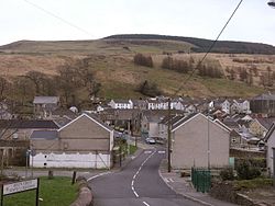
Glyncorrwg was once an important coal mining centre, typical of the South Wales Valleys. With the decline of the coal mining industry during the 1970s, buildings were cleared away, factories closed and people left the area.

In 1990, the community decided to take advantage of the local scenery and established a series of ponds along the narrow valley. Trout fishing, coarse fishing, and canoeing are now popular sports in the area. There are also miles of old flat railway trackbed lines and steep mountain slopes providing opportunities for cycling, hill walking and mountain biking.

Glyncorrwg Health Centre

Dr Julian Tudor-Hart established a famous research and teaching practice in Glyncorrwg. He arrived in 1961 and conducted a series of epidemiological studies on the practice population - a population of about 1900 which was relatively stable and which he got to know well. He established a health centre committee with a public health focus and demonstrated that systematic case-finding and regular follow-up produced real benefits. In 1987, he found that age-standardised death rates under 65 were 28% lower in Glyncorrwg than in nearby Blaengwynfi over the previous five-year period. This approach, which was the subject of many publications, led eventually to the introduction of the Quality and Outcomes Framework, which rewarded general practitioners for meeting targets for intervention in the management of disease.

Glyncorrwg Coal Company

The South Wales Mineral Railway reached Glyncorrwg in 1863. It was always short of funds so was leased to the Glyncorrwg Coal Company, which became the Glyncorrwg Colliery Company Limited in 1870. This company operated a local coal mine and needed the railway to cheaply transport coal down to Briton Ferry.

Government and politics

The electoral ward of Glyncorrwg elects a county councillor to Neath Port Talbot County Borough Council. The ward is surrounded by moorland which in turn is planted with coniferous forest. Glyncorrwg is bounded by the wards of Blaengwrach in the Vale of Neath to the north; Treherbert in the county of Rhondda Cynon Taf to the east; by Gwynfi and Cymmer in the (Afan Valley) to the south; and by Resolven to the west. [4]

In the 2012 local council elections, the electorate turnout for Glyncorrwg was 56.59%. The results were:

CandidatePartyVotesStatus
Glyn RawlingsLabour271Labour hold
Lindsay MilsomIndependent201

In the 2017 local council elections, the results were:

CandidatePartyVotesStatus
Nicola DaviesIndependent276Independent gain
Robert JoyceLabour239

In 2022. the community was abolished to form Gwynfi and Croeserw and Cymer and Glyncorrwg. [5]

Glyncorrwg falls within the Senedd and UK Parliamentary constituencies of Aberavon.

Pen y Cymoedd

In May 2012 it was announced that the Pen y Cymoedd wind farm, the highest-generating onshore wind farm in Wales, had received government backing. [6] The development is managed by Swedish-based Vattenfall, and its 76 turbines became operational in 2017. The turbines can produce enough electricity to power 15% of Welsh homes annually. [7]

See also

Related Research Articles

<span class="mw-page-title-main">Aberavon (UK Parliament constituency)</span> Parliamentary constituency in the United Kingdom, 1918 onwards

Aberavon is a constituency represented in the House of Commons of the Parliament of the United Kingdom since 2015 by Stephen Kinnock of the Welsh Labour Party. It includes the town of Aberavon, although the largest town in the constituency is Port Talbot.

<span class="mw-page-title-main">Port Talbot</span> Town and community in Wales

Port Talbot is a town and community in the county borough of Neath Port Talbot, Wales, situated on the east side of Swansea Bay, approximately eight miles from Swansea. The Port Talbot Steelworks covers a large area of land which dominates the south east of the town. It is one of the biggest steelworks in the world, but has been under threat of closure since the 1980s. The population was 31,550 in 2021, comprising about a fifth of the 141,931 population of Neath Port Talbot.

<span class="mw-page-title-main">River Afan</span> River in Wales

The River Afan is a river in Wales whose valley formed the territory of the medieval Lords of Afan. The Afan Valley encompasses the upper reaches of the river. The valley is traversed by the A4107 road. Settlements in the area include Cwmafan, Pontrhydyfen and Cymmer. The town of Aberavon, whose name in Welsh Aberafan means 'mouth of the Afan', grew up on the banks of the river and was later subsumed by the town of Port Talbot.

Abercregan is a village in the community of Cymer and Glyncorrwg, in the Welsh county borough of Neath Port Talbot, Glamorgan. It is situated around 12 kilometres (7.5 mi) north-east of Port Talbot and just west of Cymmer, and is also close to the River Afan. Abercregan was once a thriving mining community but since the decline of the British coal industry, much of the housing has been demolished and most of its inhabitants have moved to neighbouring villages. The 1980s and 1990s saw the closure of the village school, the boys club, post office and the last remaining shop 1989. The local authority decided to turn the school into a Field Study Centre, which was later closed and relocated to Margam Park. The building was demolished following the closure.

Abergwynfi is a village in the Welsh county borough of Neath Port Talbot, in the community of Gwynfi and Croeserw.

Blaengwynfi is a village in the Afan Valley, in the Neath Port Talbot area of South Wales. It is in the community of Gwynfi and Croeserw,

<span class="mw-page-title-main">Cwmafan</span> Human settlement in Wales

Cwmafan, also known as Cwmavon, is a large village and community in the Afan valley in Wales, lying within Neath Port Talbot County Borough. It had a population of 5,603 in 2001, increasing slightly to 5,615 at the 2011 Census. Cwmafan is known for having a high percentage of Welsh speakers. In many ways it is a suburb of the nearby town of Port Talbot which is less than 2 miles (3 km) to the south. The literal translation of Cwmafan from Welsh to English is complex, Cwm means valley with Afan as the name of the river flowing through, hence the village residing within the Afan Valley. It could be a version of Afon which means river, so literally the "River Valley", this is common in Wales and the UK with many rivers being called Afon or Avon. There is also a Saint Afan, which it is possible the river was named after. There have been other suggestions but none accepted locally.

Cymmer is a small village in the community of Cymer and Glyncorrwg, in Neath Port Talbot in Wales, set on a hillside in the Afan Valley near the confluence of the River Afan and the River Corrwg. In 2001, Cymmer had a population of 2,883.

Cimla is a village and suburb of the town of Neath in the county borough of Neath Port Talbot, Wales. It is set high up on a hill. It is pronounced Kim-la. The Welsh language spelling is Cymla, pronounced the same way. Its meaning is a place with common land, which it presumably was until industrial expansion led to its being covered with housing.

Sir William Jenkins was a British Labour politician and trade union leader.

The South Wales Mineral Railway was a railway built to serve collieries in the upper Afan Valley, and bring their output to a dock at Briton Ferry, in South Wales. It opened in stages, in 1861 and 1863. It was built on the broad gauge and had steep gradients, including a rope worked incline near Briton Ferry.

<span class="mw-page-title-main">A4107 road</span> Road in Wales

The A4107 road is an A road in Neath Port Talbot County Borough, Wales. It begins in Port Talbot and heads up the Afan Valley in a north easterly direction. It then continues over the moors eastwards until it connects with the A4061 road south west of Treorchy in the Rhondda Valley.

The Rhondda and Swansea Bay Railway was a Welsh railway company formed to connect the upper end of the Rhondda Fawr with Swansea, with the chief objective of transporting coal and other minerals to Swansea docks. It was incorporated in 1882, but at first the connection to Swansea from Briton Ferry was refused.

Croeserw is a village of approximately 1,380 inhabitants in Gwynfi and Croeserw, Neath Port Talbot county borough, Wales.

<span class="mw-page-title-main">Gwynfi</span> Electoral ward of Neath Port Talbot, Wales

Gwynfi is an electoral ward of Neath Port Talbot county borough, Wales.

Resolven is and electoral ward of Neath Port Talbot county borough, Wales. Resolven is made up of the parishes of Resolven and Clyne and Melincourt.

<span class="mw-page-title-main">Caerau, Bridgend</span>

Caerau is a former mining village in the community of Maesteg, Bridgend County Borough, Wales, located approximately 2 miles north of the centre of Maesteg town in the Llynfi Valley. Caerau, surrounded by mountainous terrain and forestry, is one of the border points between Bridgend County Borough and Neath Port Talbot County Borough, bordered to the north by Croeserw and Cymmer, Neath Port Talbot. Caerau, borders Dyffryn and Spelter to the south in Nantyffyllon, Maesteg.

Pen y Cymoedd is a wind farm located between Neath and Aberdare in south Wales. It opened in 2017.

<span class="mw-page-title-main">Pelenna</span>

Pelenna is a community in Neath Port Talbot, Wales. It largely covers the valleys of the rivers Pelenna and the Blaenpelenna, to the east of the town of Neath.

<span class="mw-page-title-main">Aberafan Maesteg (UK Parliament constituency)</span> Proposed United Kingdom parliamentary constituency

Aberafan Maesteg is a proposed constituency of the House of Commons in the UK Parliament. Further to the completion of the 2023 Periodic Review of Westminster constituencies, it will first be contested at the next general election.

References

Notes

  1. Davies, John; Jenkins, Nigel; Menna, Baines; Lynch, Peredur I., eds. (2008). The Welsh Academy Encyclopaedia of Wales. Cardiff: University of Wales Press. p. 321. ISBN   978-0-7083-1953-6.
  2. "Community population 2011" . Retrieved 12 April 2015.
  3. "Ward population 2011" . Retrieved 12 April 2015.
  4. "Election Maps". Ordnance Survey . Retrieved 6 September 2018.
  5. "The County Borough of Neath Port Talbot (Electoral Arrangements) Order 2021". legislation.gov.uk . Retrieved 21 May 2022.
  6. "£365m wind farm between Neath and Aberdare backed". BBC News. 8 May 2012. Retrieved 8 May 2012.
  7. "Pen y Cymoedd Wind Energy Project". Vattenfall. Retrieved 4 September 2023.