Neath is a market town and community situated in the Neath Port Talbot County Borough, Wales. The town had a population of 50,658 in 2011. The community of the parish of Neath had a population of 19,258 in 2011. Historically in Glamorgan, the town is located on the River Neath, seven miles east-northeast of Swansea.

Glynneath, also spelt Glyn-neath and Glyn Neath, is a town, community and electoral ward lying on the River Neath in the county borough of Neath Port Talbot, Wales. It was formerly in the historic county of Glamorgan. Glynneath ward covers only part of the community, with some 840 electors included in the neighbouring ward of Blaengwrach.

Pontardawe is a town and a community in the lower Swansea Valley. it had a population of approximately 7,172 in the 2021 Census for Pontardawe Parish, and forms part of the county borough of Neath Port Talbot.
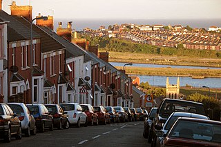
Barry is a town and community in the Vale of Glamorgan, Wales. It is on the north coast of the Bristol Channel approximately 9 miles (14 km) south-southwest of Cardiff. Barry is a seaside resort, with attractions including several beaches and the resurrected Barry Island Pleasure Park. According to Office for National Statistics 2021 estimate data, the population of Barry was 56,605.

Illtud, also known as Illtud Farchog or Illtud the Knight, is venerated as the abbot teacher of the divinity school, Bangor Illtyd, located in Llanilltud Fawr in Glamorgan, Wales. He founded the monastery and college in the 6th century, and the school is believed to be Britain's earliest centre of learning. At its height, it had over a thousand pupils and schooled many of the great saints of the age, such as David, Samson of Dol, and the historian Gildas.

The Diocese of Llandaff is an Anglican diocese that traces its roots to pre-Reformation times as heir of a Catholic bishopric. It is headed by the Bishop of Llandaff, whose seat is located at the Cathedral Church of Saint Peter and Saint Paul in Llandaff, a suburb of Cardiff. It currently covers most of the former Welsh county of Glamorgan, but once stretched from the River Towy to the middle of the Wye Valley.

Bryncoch is a village near Neath in Neath Port Talbot County Borough, Wales. The name derives from the Welsh 'red hill', originally the name of a nearby farm.
Tonna is the name of a village and community in Neath Port Talbot, Wales, located to the north-east of Neath.

Cadoxton is a district of Barry in the Vale of Glamorgan, Wales. Cadoxton was once originally its own village, separate from Barry. It grew up around Saint Cadoc's parish church, which survives. It is also home to Cadoxton Primary School, situated opposite Victoria Park which in turn is opposite Crystal Springs Conservation Group. The Group was founded in 2005 and campaigned to save the field from housing. Cadoxton Nursery is located beside the primary school.

Tonna Rugby Football Club is a rugby union team from the village of Tonna, Wales. Tonna RFC is a member of the Welsh Rugby Union and is a feeder club for the Ospreys.

Llangattock Lingoed is a small rural village in Monmouthshire, south east Wales. It is located approximately five miles north of Abergavenny, between Abergavenny and Grosmont, a few miles south of the Wales-England border. Offa's Dyke Path passes through the village. The village is near the Black Mountains and the Brecon Beacons National Park.

Llangattock-Vibon-Avel is a rural parish and former community, now in the community of Whitecastle in Monmouthshire, south-east Wales, in the United Kingdom. It is located 5 miles (8.0 km) west of Monmouth and some 13 miles (21 km) east of Abergavenny, just off the B4233 old road between the two. Villages within the former community include Llangattock itself, Skenfrith, Rockfield, and Newcastle.
Cwmcarvan is a small rural village in Monmouthshire, south east Wales. It is located 4 miles south west of Monmouth and about 4 miles east of Raglan, off the old A40 road two miles NW of Trellech.
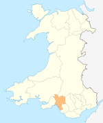
Cadoxton is an electoral ward of Neath Port Talbot county borough, Wales. It forms part of the parish of Blaenhonddan.

Llangattock is a village, community and electoral ward in the Brecon Beacons National Park in Powys, Wales. It lies in the Usk Valley just across the river from the town of Crickhowell. The Monmouthshire and Brecon Canal passes through the village en route between Brecon and Pontypool. It is in the historic county of Breconshire.
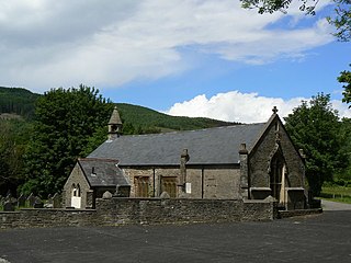
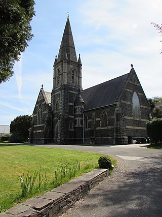
St. Cadoc's Church is a Church in Wales church in Glynneath, Wales. It is located in the grounds of the now derelict Aberpergwm House for which it was an estate church.

The Church of St Catwg in Cwmcarvan, Monmouthshire, Wales, is a parish church dating from the late 13th or early 14th century. It is dedicated to Saint Catwg or Cadoc, a 5th/6th-century Welsh saint. The existing building dates mainly from the 15th century, including its Tudor tower dating from 1525. The church was extensively restored by John Prichard in 1872–1879. It is an active parish church and a Grade II* listed building.

The Bryn, or Llangattock Nigh Usk, is a small village on the left bank of the River Usk in Monmouthshire, southeast Wales. It is accessed by a cul-de-sac minor road from the B4598 road, the reclassified former trunk road between Raglan and Abergavenny, now replaced by the modern A40 dual carriageway which runs east–west immediately north of the village. On the western edge of the village is St Cadoc's Church, a Gothic perpendicular style grade II* listed building probably dating from the fifteenth century. The village falls within the administrative community of Llanover. The Usk Valley Walk passes along the riverside path to the south.
St Cadoc's or St Cadocs or St Catwg's may refer to: