Related Research Articles

Port Talbot is a town and community in the county borough of Neath Port Talbot, Wales, situated on the east side of Swansea Bay, approximately eight miles from Swansea. The Port Talbot Steelworks covers a large area of land which dominates the south east of the town. It is one of the biggest steelworks in the world, but has been under threat of closure since the 1980s. The population was 31,550 in 2021, comprising about a fifth of the 141,931 population of Neath Port Talbot.
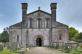
Margam Abbey was a Cistercian monastery, located in the village of Margam, a suburb of modern Port Talbot in Wales.

The M4, originally the London-South Wales Motorway, is a motorway in the United Kingdom running from west London to southwest Wales. The English section to the Severn Bridge was constructed between 1961 and 1971; the Welsh element was largely complete by 1980, though a non-motorway section around Briton Ferry bridge remained until 1993. On the opening of the Second Severn Crossing in 1996, the M4 was rerouted over it.

Aberavon is a town and community in Neath Port Talbot county borough, Wales. The town derived its name from being near the mouth of the river Afan, which also gave its name to a medieval lordship. Today it is essentially a district of Port Talbot, covering the central and south western part of the town. Aberavon is also the name of the nearby Blue Flag beach and the parish covering the same area.
Margam is a suburb and community of Port Talbot in the Welsh county borough of Neath Port Talbot, Wales, close to junction 39 of the M4 motorway. The community had a population of 3,017 in 2011; the built up area being larger and extending into Taibach community.

Margam Country Park is a country park estate in Wales, of around 850 acres (3.4 km2). It is situated in Margam, about 2 miles (3 km) from Port Talbot in south Wales. It was once owned by the Mansel Talbot family and is now owned and administered by the local council, Neath Port Talbot County Borough Council. Situated within the park are three notable buildings: Margam Abbey, a Cistercian monastery; Margam Castle, a neo-Gothic country house that was once the seat of the Mansel Talbot family; and the 18th-century Orangery. The park is designated Grade I on the Cadw/ICOMOS Register of Parks and Gardens of Special Historic Interest in Wales.
Abercregan is a village in the community of Cymer and Glyncorrwg, in the Welsh county borough of Neath Port Talbot, Glamorgan. It is situated around 12 kilometres (7.5 mi) north-east of Port Talbot and just west of Cymmer, and is also close to the River Afan. Abercregan was once a thriving mining community but since the decline of the British coal industry, much of the housing has been demolished and most of its inhabitants have moved to neighbouring villages. The 1980s and 1990s saw the closure of the village school, the boys club, post office and the last remaining shop 1989. The local authority decided to turn the school into a Field Study Centre, which was later closed and relocated to Margam Park. The building was demolished following the closure.

Pyle is a village and community in Bridgend county borough, Wales. This large village is served by the A48 road, and lies less than one mile from Junction 37 of the M4 motorway, and is therefore only a half-hour journey from the capital city of Wales, Cardiff. The nearest town is the seaside resort of Porthcawl. Within the Community, to the northeast of Pyle, is the adjoining settlement of Kenfig Hill, North Cornelly also adjoins Pyle and the built-up area had a population of 13,701 in 2011.

Bryn is a village and community in Neath Port Talbot County Borough in Wales. It has a population of 913. The village is located in the hills between Cwmafan, in the Afan Valley, and Maesteg in the Llynfi Valley, approximately 6 miles (9.7 km) from Port Talbot and 2 miles (3.2 km) from Maesteg. The name of the village now familiarly 'Bryn', is Bryntroedygam. So wrote the first vicar of St Theodore's in Port Talbot. There was a farm situated above Meadow Row named Bryn-Troed-y-Garn as shown on the 1876 OS map, as many more immigrants came to 'Bryntroedygam' it seemed the name of the village was to be shorted to Bryn. 12% of the village speak Welsh. The population rose to 923 by 2011.

Port Talbot Steelworks is a steel mill in Port Talbot, Wales. Over 4,000 people worked at the plant until the last blast furnace closed in October 2024. Around 2,000 employees remain after this time, processing imported steel slabs to produce rolled steel products. The mill is in the process of building a 320-ton capacity electric arc furnace which would be operational in late 2027.
Sandfields is a mainly residential district of Port Talbot, Wales. The area is located in South Wales on a narrow coastal plain between Mynydd Dinas and the sea. The M4 motorway, A48 trunk road and South Wales Main Line run nearby. The area includes a council estate, industrial areas and a seaside resort at Aberavon Beach.

Llandarcy is a village near Neath in the Neath Port Talbot county borough, Wales, and was the site of the first oil refinery in the United Kingdom. It was originally designed as a garden village to house the workers for the BP refinery built between 1918 and 1922. The village is near junction 43 of the M4 motorway.
The Aberafan Shopping Centre is the only indoor shopping complex in Port Talbot, Wales. It currently has a floorspace of 24,100 m2 (259,000 sq ft) and houses over sixty stores on two levels, as well as the central library for Port Talbot. It was built in the 1970s by Star Dolphin Developments and was refurbished in the late 1990s. It replaced parts of the old town centre, which was substantially demolished between 1971 and 1976 to accommodate a flyover section of the M4 motorway.

The A4119 links Tonypandy with Cardiff in South Wales.

The A4241 Port Talbot Peripheral Distributor Road is a distributor road serving Port Talbot, Wales.

The Baglan electoral ward includes the communities of Baglan and Baglan Bay, in Neath Port Talbot county borough, Wales. Baglan falls within the parliamentary constituency of Aberavon.

The electoral ward of Aberavon electoral ward includes the communities of Baglan and Baglan Bay, in Neath Port Talbot county borough, Wales. Baglan falls within the parliamentary constituency of Aberavon.

Beulah Calvinistic Methodist Chapel, also known locally as "The Round Chapel" and in Welsh as "Capel y Groes", is a Grade II*-listed building in Margam, Port Talbot, Wales. It originally built in the mid-nineteenth century and had to be dismantled and moved in 1974 to make way for the new M4 motorway.
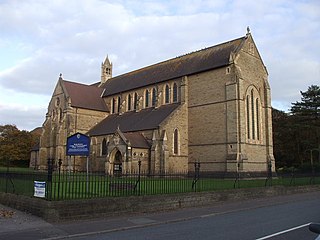
The Church of St Theodore is a parish church of the Church in Wales in Port Talbot, Wales. Located on the A48 opposite Maes-y-Cwrt Terrace and bordered on two sides by the Talbot Memorial Park, it is administered within the diocese of Llandaff.

Holy Cross Church, Port Talbot, also known locally as the "Chapel of Ease", is a Victorian church located centrally in the Taibach district of Port Talbot, Wales. Prior to the building of the M4 motorway flyover through the centre of the town in the 1960s, it was in the centre of a residential area, but it is now dominated by junction 40 of the motorway. The land was originally donated by C. R. M. Talbot, MP, the owner of the Margam Abbey estate, as a church for local people who could not get to the abbey itself to worship.
References
- 1 2 3 "Invisible Scars" (blog). Port Talbot Historical Society. 4 September 2013. Retrieved 5 December 2017.
- 1 2 3 4 Geraint Thomas (3 December 2017). "The 'Cotswolds-like' Welsh village reduced to rubble to make way for the M4". Wales Online . Retrieved 5 December 2017.
- ↑ "Topping out ceremony marks key milestone in the construction of Ysgol Cwm Brombil". Neath Port Talbot County Borough Council. 13 February 2018. Retrieved 9 May 2018.
51°34′07″N3°44′47″W / 51.5686°N 3.7463°W
| | This Neath Port Talbot location article is a stub. You can help Wikipedia by expanding it. |