Aboriginal sites of New South Wales

Last updated

Baiame Cave, Milbrodale BaiameCaveBulga0003.jpg
Baiame Cave, Milbrodale

Aboriginal sites of New South Wales consist of a large number of places in the Australian state of New South Wales where it is still possible to see visible signs of the activities and culture of the Australian Aboriginals who previously occupied these areas.

Contents

These sites are comparable with the petroglyphs of Native Americans and the Rock Art found elsewhere in Australia, but are not restricted to rock carvings. Many of the sites are on the (now defunct) Register of the National Estate. [1]

History and description

The Aboriginal Australians arrived in the north of Australia at least 70,000 [2] years ago, and potentially 120,000 years ago [3] Sites over 22,000 years old have been found in the Blue Mountains area west of Sydney, while sites going back 40,000 years exist at Lake Mungo. [4] There are some thousands of known sites, many but not all located in national parks. Some sites are also found in more suburban settings; rock carvings can be seen in the Sydney suburbs of Bondi and Tamarama.

Their art was part of day-to-day life and would normally have had a purpose. One such purpose is thought to have been what some people call "wish fulfilment magic"—or sympathetic magic—in which the act of creating the magical work is thought to bring about the event depicted in the work. For example, a hunting scene—a common subject in rock carvings—would be aimed at bringing about the desired reality of good hunting. [5]

There were also many artworks that were created for specific ceremonial purposes and which were not intended to last after the ceremony was over. [6] In addition to such themes, there were also works of a more secular nature, which could be created for a number of reasons, including the instruction and entertainment of children.

There are substantial variations in the character of art developed in different parts of New South Wales. Art in the western part of the state could be very different from the art created in coastal areas. Aboriginal sites in the state are administered by the National Parks and Wildlife Service of New South Wales. All known sites are recorded on the register known as the Aboriginal Heritage Information Management System (AHIMS), which is run by the National Parks and Wildlife Service. [7]

There is generally a policy of protecting Aboriginal sites, although a small number of sites are publicised. Notable examples are those at the Basin Track, Ku-ring-gai Chase National Park, and the Bulgandry site, Brisbane Water National Park. However, most sites are not publicised, and restricted sites (colloquially known as sacred sites) will never be made public. If anyone thinks they have a legitimate reason for wanting to inspect sites that are not normally available to the public, they can apply to AHIMS for permission.

The sites are of many different types, for example:

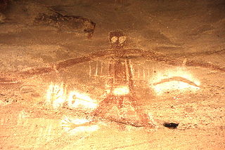
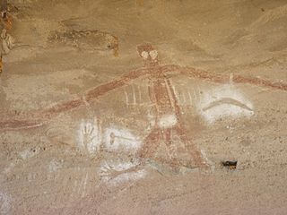
Paintings cover a wide range of subjects, both spiritual and secular. Coloured pigmentation was created with ochre (giving a red/orange colour), charcoal (for a black pigmentation) and ash (for grey pigmentation). One good example is the rock shelter popularly known as Baiame's Cave, at Milbrodale, with paintings depicting a large figure that may be Baiame, the Sky Father.

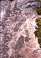
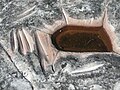
Rock carvings, also known as petroglyphs or Rock Engravings, are of a style known as "simple figurative", which conventional archaeological thinking dates to the last 5000 years. Other engravings show European sailing ships, and so cannot be more than about 200 years old. Thus we are left with a date range of 5000–200 years ago. It is likely that some of the freshest engravings represent the later part of that time range, whilst the most worn represent the earliest part. However, the situation is complicated by the fact that we know the engravings were sometimes "re-grooved" during ceremonies. Carvings could be very large. In some carvings, the figure of Baiame the Sky Father could be eighteen metres tall. [8]

In addition to pictorial carvings, there are many grinding grooves, caused by grinding stone implements on a rock surface to shape them and give them an edge. Areas like Sydney and the Blue Mountains have many rock carvings because they predominantly consist of sandstone (known as Hawkesbury sandstone), which is a very suitable surface for rock carvings. See Sydney Rock Engravings for the main article on these.

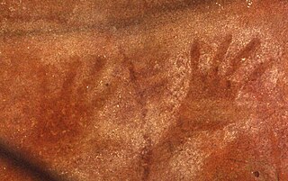
Hand stencils can often be found in rock shelters and caves, which have given them protection from the elements over the years. They were created by placing the hand on a rocky surface and blowing pigmentation around it, leaving the silhouette of the hand on the rock. There is often a number of them in one place. The best-known example is Red Hands Cave, in the Blue Mountains National Park, which has many stencils, including those created by children as well as adults. [9]

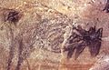
Charcoal drawings were exactly that: drawings executed with a piece of charcoal. Like the rock carvings, they could be of a wide range of subjects, with animals often featured.

Shell middens developed in occupation sites where shell fish were consumed. Over the years, layers of shells would build up, creating a concentration of many shells in the soil around the occupation site.

Shield trees are seen occasionally in the Sydney bush. A substantial piece of bark would be cut out of a tree and used as a shield or tray. A visible "scar" was thus left behind, which could vary considerably in size, some being quite large.

Restricted areas (otherwise known as sacred sites) are usually of a spiritual nature and were restricted to adult males and, in some cases, women. These sites could include ceremonial sites, bora grounds, men's sites and women's birthing sites.

Occupation sites and sacred sites

It is necessary to distinguish between occupation sites and sacred sites, a subject about which there is often great confusion. Many people think that all Aboriginal sites are "sacred sites", but the reality is more complex. Before white settlement, most indigenous sites were occupation sites, which were used by all members of a tribe. Sacred sites, on the other hand, were restricted to adult males, except for certain women's sites. In more recent times, all indigenous sites have become known as sacred sites; those that were previously known as sacred sites are now known as restricted sites.

Imitations

It is worth noting that there are many imitation sites, in which Europeans created imitations of Aboriginal art, usually in the form of rock carvings. One of the most prominent examples is a large carving of a kangaroo alongside a walking track at Grotto Point, in the Sydney Harbour National Park. This has been known for some time to be an imitation (or fake, as some would say). [10]

Examples

See also

Related Research Articles

<span class="mw-page-title-main">Blue Mountains (New South Wales)</span> Mountain range in New South Wales, Australia

The Blue Mountains are a mountainous region and a mountain range located in New South Wales, Australia. The region is considered to be part of the western outskirts of the Greater Sydney area. The region borders on Sydney's main metropolitan area, its foothills starting about 50 kilometres (31 mi) west of centre of the state capital, close to Penrith. The public's understanding of the extent of the Blue Mountains is varied, as it forms only part of an extensive mountainous area associated with the Great Dividing Range. As defined in 1970, the Blue Mountains region is bounded by the Nepean and Hawkesbury rivers in the east, the Coxs River and Lake Burragorang to the west and south, and the Wolgan and Colo rivers to the north. Geologically, it is situated in the central parts of the Sydney Basin.

<span class="mw-page-title-main">Baiame</span> Creator god and sky father in Australian Aboriginal mythology

In Australian Aboriginal mythology, Baiame is the creator god and sky father in the Dreaming of several Aboriginal Australian peoples of south-eastern Australia, such as the Wonnarua, Kamilaroi, Guringay, Eora, Darkinjung, and Wiradjuri peoples.

<span class="mw-page-title-main">Mutawintji National Park</span> Protected area in New South Wales, Australia

The Mutawintji National Park, formerly the Mootwingee National Park, is a protected national park that is located in the Far West region of New South Wales, in eastern Australia. The 68,912-hectare (170,290-acre) national park is situated approximately 880 kilometres (550 mi) west of Sydney and about 130 kilometres (81 mi) north-east of Broken Hill.

<span class="mw-page-title-main">Wollemi National Park</span> Protected area in New South Wales, Australia

The Wollemi National Park is a protected national park and wilderness area that is located in the Central West and Hunter region of New South Wales, in eastern Australia. The 501,703-hectare (1,239,740-acre) park, the second largest national park in New South Wales, contains the 361,113-hectare (892,330-acre) Wollemi Wilderness – the largest such wilderness area in Australia – and is situated approximately 130 kilometres (81 mi) northwest of Sydney.

<span class="mw-page-title-main">Indigenous Australian art</span> Art made by Aboriginal and Torres Strait Islander peoples of Australia

Indigenous Australian art includes art made by Aboriginal Australians and Torres Strait Islanders, including collaborations with others. It includes works in a wide range of media including painting on leaves, bark painting, wood carving, rock carving, watercolour painting, sculpting, ceremonial clothing and sandpainting; art by Indigenous Australians that pre-dates European colonisation by thousands of years, up to the present day.

<span class="mw-page-title-main">Rock art</span> Human-made markings on natural stone

In archaeology, rock art is human-made markings placed on natural surfaces, typically vertical stone surfaces. A high proportion of surviving historic and prehistoric rock art is found in caves or partly enclosed rock shelters; this type also may be called cave art or parietal art. A global phenomenon, rock art is found in many culturally diverse regions of the world. It has been produced in many contexts throughout human history. In terms of technique, the four main groups are:

The Gamilaroi, also known as Gomeroi, Kamilaroi, Kamillaroi and other variations, are an Aboriginal Australian people whose lands extend from New South Wales to southern Queensland. They form one of the four largest Indigenous nations in Australia.

<span class="mw-page-title-main">Dharawal</span> Australian Aboriginal people of southern and south western areas of Sydney

The Tharawal people and other variants, are an Aboriginal Australian people, identified by the Yuin language. Traditionally, they lived as hunter–fisher–gatherers in family groups or clans with ties of kinship, scattered along the coastal area of what is now the Sydney basin in New South Wales.

<span class="mw-page-title-main">Sydney rock engravings</span>

Sydney rock engravings, or Sydney rock art, are a form of Australian Aboriginal rock art in the sandstone around Sydney, New South Wales, Australia, that consist of carefully drawn images of people, animals, or symbols. Many thousands of such engravings are known to exist in the Sydney region, although the locations of most are not publicised to prevent damage by vandalism, and to retain their sanctity, as they are still regarded as sacred sites by Indigenous Australians. There are two art environments in Sydney Basin, rock shelters and engraving sites.

The Bidjigal Reserve is a 186-hectare (460-acre) reserve in New South Wales, Australia. It lies predominantly within The Hills Shire, with a small section south of the M2 Motorway in the City of Parramatta. The reserve lies in the suburbs of North Rocks, Northmead, Baulkham Hills, Castle Hill, West Pennant Hills, and Carlingford. The reserve lies south of Richard Webb Reserve in West Pennant Hills, with the majority located to the north of the M2 Motorway.

<span class="mw-page-title-main">Bora (Australian)</span>

Bora is an initiation ceremony of the Aboriginal people of Eastern Australia. The word "bora" also refers to the site on which the initiation is performed. At such a site, boys, having reached puberty, achieve the status of men. The initiation ceremony differs from Aboriginal culture to culture, but often, at a physical level, involved scarification, circumcision, subincision and, in some regions, also the removal of a tooth. During the rites, the youths who were to be initiated were taught traditional sacred songs, the secrets of the tribe's religious visions, dances, and traditional lore. Many different clans would assemble to participate in an initiation ceremony. Women and children were not permitted to be present at the sacred bora ground where these rituals were undertaken.

<span class="mw-page-title-main">Milbrodale, New South Wales</span>

Milbrodale is a village in the Hunter Region of New South Wales, Australia. It is in the local government area of Singleton Council.

<span class="mw-page-title-main">Monuments of Australia</span>

Australia's monuments take on many distinct forms, including statues, fountains, natural landmarks and buildings. Whilst some monuments of Australia hold a national significance, many are constructed and maintained by local community groups, and are primarily significant on a local scale. Although Australia's monuments have many roles, including as tourist attractions, their primary purpose is to "safeguard, prolong or preserve social memory into the future". This social memory may relate to anything from colonisation to local industry to sports. The monuments of Australia reflect the nation's social and political history and by memorialising select moments, contribute to shaping how Australian history is told. Although a significant portion of Australia is desert, the population is highly urbanised and the cities contain some noteworthy monuments.

Bull Cave is a heritage-listed art site at Darling Avenue, Kentlyn, City of Campbelltown, New South Wales, Australia. It is also known as Bull's Cave and The Bull Cave. It was added to the New South Wales State Heritage Register on 28 August 2017.

<span class="mw-page-title-main">Baiame Cave</span> Historic site in New South Wales, Australia

Baiame Cave is a heritage-listed cave and cultural site of the Wonnarua people at Milbrodale, Singleton Council, New South Wales, Australia. It is also known as Baiame’s Cave, Creator Cave, Dhurramulan, Goign, Wabooee, Baiamai, Biami, Baimae, Biamie, Biaime, Byarmie and Byarme. It was added to the New South Wales State Heritage Register on 31 July 2015.

Earlwood Aboriginal Art Site is a heritage-listed Aboriginal cultural site at Earlwood, City of Canterbury-Bankstown, New South Wales, Australia. It is also known as Aboriginal Art and Midden. It was added to the New South Wales State Heritage Register on 27 November 2009.

Calga Aboriginal Cultural Landscape is a heritage-listed site at Peats Ridge Road, Calga, Central Coast Council, New South Wales, Australia. It is also known as Calga Aboriginal Women's Site and Calga Aboriginal Sites. It was added to the New South Wales State Heritage Register on 1 October 2019.

The Blue Labyrinth is an area covering much of the southern part of Blue Mountains National Park in New South Wales, Australia. It spans an area south of the Great Western Highway from Wentworth Falls to Glenbrook, stretching from Kings Tableland in the west to Warragamba Dam and the Nepean River in the east, and the Burragorang Valley to the south.

<span class="mw-page-title-main">Red Hands Cave</span> Australian Aboriginal rock art site

Red Hands Cave is an Australian Aboriginal rock art site in the Blue Labyrinth area of Blue Mountains National Park. It is a rock shelter located within walking distance from the town of Glenbrook, New South Wales.

References

  1. Heritage of Australia, Macmillan Publishers, 1981, pp.50-67
  2. Davidson, Helen; Wahlquist, Calla (19 July 2017). "Australian dig finds evidence of Aboriginal habitation up to 80,000 years ago | Indigenous Australians". The Guardian.
  3. "Ancient Aboriginal site Moyjil could rewrite the global story of human migration - ABC News". ABC News. 4 September 2020.
  4. 2003 Guide to NSW National Parks (National Parks and Wildlife Service) 2003, p.59
  5. Aboriginal Art of Australia, Barbara Mullins (Mulavon Pty Ltd) 1986, p.8
  6. Aboriginal Art of Australia, p.33
  7. "AHIMS website:Retrieved 17 September 2009".
  8. Aboriginal Art of Australia, p.11
  9. Sydney and Blue Mountains Bushwalks, Neil Paton (Kangaroo Press) 2004, p.170
  10. Walks in the Sydney Harbour National Park, Neil Paton (Kangaroo Press) 1987, p.31
  11. 1 2 Heritage of Australia, p.2/211
  12. 2003 Guide to NSW National Parks, p.32
  13. Sydney and Blue Mountains Bushwalks, p.57
  14. Sydney and Blue Mountains Bushwalks, p.132
  15. Koonadan Historic Site: Plan of management (PDF) (PDF). Government of New South Wales. September 1996. ISBN   0-7310-0855-3 . Retrieved 17 May 2019.{{cite book}}: |work= ignored (help)
  16. 2003 Guide to NSW National Parks, p.35
  17. Heritage of Australia, Macmillan Publishers, 1981, p.2/290
  18. 2003 Guide to NSW National Parks, p.59
  19. 1 2 2003 Guide to NSW National Parks, p.60
  20. 2003 Guide to NSW National Parks, p.17
  21. 2003 Guide to NSW National Parks, p.40