
Accrington is a town in the Hyndburn borough of Lancashire, England. It lies about 4 miles (6 km) east of Blackburn, 6 miles (10 km) west of Burnley, 13 miles (21 km) east of Preston, 20 miles (32 km) north of Manchester and is situated on the culverted River Hyndburn. Commonly abbreviated by locals to "Accy", the town has a population of 35,456 according to the 2011 census.
Calvert is a village in Buckinghamshire, England, near the village of Steeple Claydon.

Hyndburn is a local government district with borough status in Lancashire, England. Its council is based in Accrington, the largest town, and the borough also covers the outlying towns of Clayton-le-Moors, Great Harwood, Oswaldtwistle and Rishton. The borough was created in 1974 and takes its name from the River Hyndburn. It had a population of 80,734 at the 2011 Census. Elections to the council are held in three out of every four years, with one third of the 35 seats on the council being elected at each election. Both the Conservative and Labour parties have controlled the council at different times, as well as periods when no party has had a majority.

Stewartby is a model village and civil parish in Bedfordshire, England, originally built for the workers of the London Brick Company. The village was designed and built to the plans of the company's architect Mr F W Walker, laid out on 'Garden City' principle, a later and more modern development than such better-known Victorian model villages as Saltaire. Started in 1926, Stewartby is also a later model than Woodlands which was first planned in 1905. The later retirement bungalow development of the 1950s and 1960s with the pavilion community centre in their midst was designed by the neo-Georgian architect Professor Sir Albert Richardson. Today, Stewartby parish also includes Kempston Hardwick.
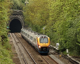
Clay Cross Tunnel is a 1,784 yards (1,631 m) tunnel on the Midland Main Line line near Clay Cross in Derbyshire, England. It was the most substantial single civil engineering feature present on the North Midland Railway and was one of the more ambitious railway tunnels to be built during the early development of Britain's railway network.

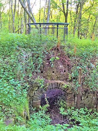
A brickworks, also known as a brick factory, is a factory for the manufacturing of bricks, from clay or shale. Usually a brickworks is located on a clay bedrock, often with a quarry for clay on site. In earlier times bricks were made at brickfields, which would be returned to agricultural use after the clay layer was exhausted.

Altham is a village and civil parish in the Borough of Hyndburn, in Lancashire, England. The village is 4 miles (6.4 km) west of Burnley, 3 miles (4.8 km) north of Accrington, and 2 miles (3.2 km) north-east of Clayton-le-Moors, and is on the A678 Blackburn to Burnley road.
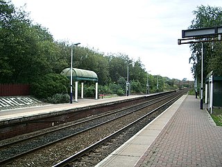
Huncoat railway station is a railway station which serves the village of Huncoat, between Accrington and Burnley in Lancashire, England. The station is 8 miles (13 km) east of Blackburn railway station on the East Lancashire Line operated by Northern.
The London Brick Company, owned by Forterra plc, is a leading British manufacturer of bricks.

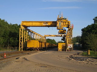
Marston Vale is an area of Bedfordshire. It lies to the south west of Bedford and Kempston, near Junction 13 of the M1 motorway. Historically it was one of the main brickmaking districts in England, home of the London Brick Company, now a division of Hanson plc. The brickmaking activity left scars across the landscape of the Marston Vale as large tracts of land were dug for clay. Most of the claypits are now exhausted, and most of the brickmaking chimneys have been demolished. The legacy of the abandoned brickworks also adds to the impression that the Marston Vale has been despoiled by decades of industrial activity and it is now searching for a new identity. In more recent years the local authorities have taken the opportunity to reuse the clay pits for landfills at Stewartby and Brogborough, both of which are recently capped and closed down.
Huncoat is a village in Lancashire, England; situated in the North West. It is located to the east of Accrington. It is a ward of Hyndburn where the population taken at the 2011 census was 4,418.

Glenboig is a village in North Lanarkshire, Scotland lying north of Coatbridge and to the south east of Kirkintilloch and is approximately ten miles from Glasgow City Centre. According to a 2020 estimate, the population of Glenboig was 2,990.
Bradford Colliery Brickworks operated on the site of the Bradford Colliery in Bradford, Manchester, then in the historic county of Lancashire, England, between the early 1870s and 1903. To exploit the seams of fire clay found between the coal seams, colliery manager Edward Williams built a large kiln to a design patented in 1870 by Friedrich Hoffmann, which permitted the continuous production of bricks. One of the largest brick-making facilities in the area, the kiln was more than 30 metres (98 ft) long and 17 metres (56 ft) wide, and probably contained 12–14 separate firing chambers.

Hameldon Hill is a Carboniferous sandstone hill with a summit elevation of 409 metres (1,342 ft), situated between the towns of Burnley and Accrington in Lancashire, England. It is listed as a "HuMP" or "Hundred Metre Prominence", its parent being Freeholds Top, a Marilyn near Bacup.

A by-thirds Hyndburn Borough Council local election took place on 5 May 2016. Approximately one third of the local council's 35 seats fell up for election on that day. The following year sees Lancashire County Council elections for all residents of this borough.

The Burnley Coalfield is the most northerly portion of the Lancashire Coalfield. Surrounding Burnley, Nelson, Blackburn and Accrington, it is separated from the larger southern part by an area of Millstone Grit that forms the Rossendale anticline. Occupying a syncline, it stretches from Blackburn past Colne to the Yorkshire border where its eastern flank is the Pennine anticline.
Towneley Colliery or Towneley Desmesne was a coal mine on the Burnley Coalfield in Burnley, Lancashire, England. Sunk in the late 1860s, it was linked to the Lancashire and Yorkshire Railway's Burnley to Todmorden line which became known as the Copy Pit route and, by tramway, to the Leeds and Liverpool Canal.

The Darnley Lime Works Tramway and Mineral Railway consisted of a narrow gauge field railway and probably a standard gauge works railway at today's Dams to Darnley Country Park in East Renfrewshire, 9.7 km southwest of Glasgow. They were successively operated at least from 1898 to 1959.
Accrington power station was a coal and refuse fired electricity generating station located in the centre of Accrington, Lancashire. The station supplied electricity to Accrington and to Haslingden and the Altham and Clayton-le-Moors areas between 1900 and 1958.

