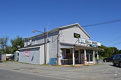
Aden, Virginia

Last updated
Aden
Aden Grocery.jpg
Aden Grocery
USA Virginia Northern location map.svg
Red pog.svg
Aden
Location within the state of Virginia
USA Virginia location map.svg
Red pog.svg
Aden
Aden (Virginia)
Usa edcp location map.svg
Red pog.svg
Aden
Aden (the United States)
Coordinates: 38°39′18″N77°32′14″W / 38.65500°N 77.53722°W / 38.65500; -77.53722 Coordinates: 38°39′18″N77°32′14″W / 38.65500°N 77.53722°W / 38.65500; -77.53722
Country United States
State Virginia
County Prince William
Time zone UTC−5 (Eastern (EST))
  Summer (DST) UTC−4 (EDT)

Aden is an unincorporated community in Prince William County, Virginia, United States. The town is centered at the intersection of Aden Road and Fleetwood Drive approximately four miles due south of Manassas Airport. Aden does not have the characteristics of a distinct town entity, but one building on the northern corner bears the name "Aden Grocery". The only other building near the intersection is a single residential home.

Effingham was added to the National Register of Historic Places in 1989. [1]

Related Research Articles

National Register of Historic Places listings in Franklin County, Massachusetts

This is a list of the National Register of Historic Places listings in Franklin County, Massachusetts.

Borodino, New York hamlet in New York, United States

Borodino is a hamlet located at the intersection of New York State Route 41 and New York State Route 174 in the Town of Spafford in Onondaga County, New York, near Skaneateles Lake. The hamlet proper extends five to ten properties to the east, south, west and north from the intersection, until houses and a few other buildings are replaced by farm fields. A monument for veterans, designed by Gianfranco Fritelli, stands in a cemetery at the southeast corner of the intersection. A little-altered Federal style Methodist Church, known locally as "The Church", dating from 1830, stands close to the 174, about five properties north. The Borodino District School No. 8 and Borodino Hall (1835) are listed on the National Register of Historic Places.

Sugartown, Pennsylvania United States historic place

Sugartown is an unincorporated settlement in central Willistown Township, Chester County, Pennsylvania, United States, at the intersection of Sugartown and Boot Roads. It is located 18 miles west of Philadelphia.

Shushan Bridge United States historic place

Shushan Bridge is a covered bridge over the Batten Kill in the hamlet of Shushan in Washington County, New York, near Vermont. It is one of 29 surviving historic covered bridges in New York State, and one of 4 surviving in Washington County.

Preston City, Connecticut United States historic place

Preston City is a village and the original town center of the town of Preston, Connecticut. The core of the village around the junction of Old Northwest Road and Route 164 is designated as the Preston City Historic District, a historic district that is listed on the National Register of Historic Places. The district is located along Old Shetucket and Amos Roads, which, prior to the 1930s, were major thoroughfares.

Columbia Green Historic District United States historic place

Columbia Green Historic District is a historic district that includes the town green, Columbia Green, of the town of Columbia, Connecticut, United States. The district includes buildings around the green and extending northwest along Route 87. The district was listed on the National Register of Historic Places in 1990. It comprises 43 buildings, 2 sites, and 1 object that contribute to the historical significance of the area.

Old Town House (Marblehead, Massachusetts) United States historic place

The Old Town House is in the heart of the Marblehead Historic District at One Market Square in Marblehead, Massachusetts, at the intersection of Washington, State, and Mugford Streets.

Common Historic District (Reading, Massachusetts) United States historic place

The Common Historic District is a historic district encompassing the civic and institutional heart of Reading, Massachusetts. The district is centered on the town common, at the intersection of Main and Salem Streets. The common has been communally owned since at least 1737, with the original burying ground to the north. In 1769 the area's first meeting house was built, giving the area a sense of identity separate from portions of Reading that would later be set off as Wakefield and North Reading. Since then the area has become a focal point for religious and civic institutions in the town.

Stoneham Public Library United States historic place

The Stoneham Public Library is the public library of Stoneham, Massachusetts. It is located at Main and Maple Streets.

House at 380 Albion Street United States historic place

The House at 380 Albion Street in Wakefield, Massachusetts is one of the finest Bungalow/Craftsman style houses in the town. It was built c. 1910 in a then-rural part of Wakefield that been annexed from Stoneham in the 1880s. The house was listed on the National Register of Historic Places in 1989.

Greenwich Avenue Historic District United States historic place

The Greenwich Avenue Historic District is a historic district representing the commercial and civic historical development of the downtown area of the town of Greenwich, Connecticut. The district was listed on the National Register of Historic Places on August 31, 1989. Included in the district is the Greenwich Municipal Center Historic District, which was listed on the National Register the year before for the classical revival style municipal buildings in the core of Downtown. Most of the commercial buildings in the district fall into three broad styles, reflecting the period in which they were built: Italianate, Georgian Revival, and Commercial style. The district is linear and runs north–south along the entire length of Greenwich Avenue, the main thoroughfare of Downtown Greenwich, between U.S. Route 1 and the New Haven Line railroad tracks.

Scenery Hill Historic District United States historic place

Scenery Hill Historic District is a historic district in Scenery Hill, Pennsylvania, listed on the National Register of Historic Places in 1996. It is a typical Pike Town along the National Road. Most of the buildings in the district were constructed during the two boom periods of the road, c. 1818 – c. 1853 and c. 1910 – c. 1930. The district contains 93 buildings of many types: taverns, shops, service facilities and residences. Most of the commercial buildings are clustered in the center of the district, east of the National Road intersection with Spring Valley and Fava Farm Roads.

Syndicate Block (Des Moines, Iowa) United States historic place

The Syndicate Block, also known as the McCoy Building, is an historic building located in the East Village of Des Moines, Iowa, United States. It was individually listed on the National Register of Historic Places in 2001. In 2019 the building was included as a contributing property in the East Des Moines Commercial Historic District.

Perry and Brainard Block United States historic place

The Perry and Brainard Block, also known as the North Des Moines Town Hall, is a historic building located in Des Moines, Iowa, United States. The structure was built between 1888 and 1889 and the second floor served as the city hall for the suburb of North Des Moines. In the late 19th century Des Moines actively sought to annex its Victorian suburbs, with North Des Moines being the largest of these communities. This is the only known public building that has survived from the Annexation Movement era. The local government and community of North Des Moines debated annexation, not only of the municipalities, but of their schools as well. It was also the only community where the residents voted on the annexation issue, and this building also served as a polling place. The building served as the location of the celebration after the referenda passed in 1890. After its use as the city hall, the second floor became the lodge for the Ancient Order of United Workmen.

Lisbon Historic District United States historic place

The Lisbon Historic District is located at the intersection of U.S. Route 30 and Ohio route 45 in Lisbon, Ohio. The district covers approximately 42 acres (17 ha). The town of Lisbon was located along important land and water transportation routes from the east into newly settled territories in the west. As a result of this, Lisbon, the second oldest town in Ohio, played an important part in the development of Ohio, which had been granted statehood in 1803.

Water Company of Tonopah Building United States historic place

The Water Company of Tonopah Building is a historic building located at the intersection of Burrough and Brougher Avenues in Tonopah, Nevada. Built in 1909, the building housed offices for the Water Company of Tonopah. Tonopah's first water service began in 1902, when three water companies each gained franchises to provide water to one district of the town. By 1905, Philadelphia businessman John Brock owned two of the water companies, which he consolidated into the Water Company of Tonopah. Brock also owned multiple mines in Tonopah and the local railroad. The Water Company of Tonopah Building is the only surviving building which belonged to one of Tonopah's early water companies.

Tonopah Volunteer Firehouse and Gymnasium United States historic place

The Tonopah Volunteer Firehouse and Gymnasium is a historic fire station located at the intersection of Brougher and Burro Streets in Tonopah, Nevada. Built in 1907, the firehouse housed Tonopah's volunteer fire department. The firehouse was built by Tonopah's newly appointed fire chief to address inadequacies in the town's fire protection services, which had failed to stop a major fire in 1904. A gymnasium for the firefighters was constructed next to the fire station in 1908. Tonopah still suffered three major fires after its fire station was built, including a 1920 fire which damaged the station itself; the building was subsequently restored to its original condition.

McAdenville Historic District United States historic place

McAdenville Historic District is a national historic district located at McAdenville, Gaston County, North Carolina. It encompasses 93 contributing buildings, 2 contributing sites, and 7 contributing structures in the mill village associated with McAden Mills, a cotton mill chartered by the state legislature in 1881. The buildings were built between about 1884 and 1959, and include notable examples of Late Victorian and Italianate architecture. Notable buildings include 15 brick mill worker houses, remnants of McAden Mill No. 1 (1881–82) and McAden Mill No. 2 (1884–85), McAden Mill No. 3 (1906–07), and Pharr Corporate Offices redesigned by Earle Sumner Draper.

Waterloo Masonic Temple United States historic place

The Waterloo Masonic Temple is a historic building located in Waterloo, Iowa, United States. The first Masonic lodge in town, No. 105 A.F. & A.M, was established on the west side of the Cedar River in 1857. Lodge No. 296 was organized on the east side of the river in 1871, and the two consolidated into one lodge eight years later. They built their first Masonic Temple in 1899 at the intersection of Sycamore Street and East Park Avenue. The city was in the midst of a period economic growth that would see its population double each decade from 1890 to 1910. By 1918 the Masons felt the need for a new facility. Property at the intersection of East Park Avenue and Mulberry Street was acquired in 1920. Local architect John G. Ralston, a fellow Mason, was chosen to design the new building in what has been termed the "Phoenician Revival" style. The exterior walls were completed in 1925, but the interior wasn't completed until 1928. It is a four-story structure built over a raised basement. Its exterior walls are composed of dark red brick accented with light grey limestone. The main façade features a central entrance pavilion with three entrance ways that terminate in Moorish peaks near the roofline. Various Masonic symbols are found carved into the stone, and decorative brickwork flanks the central stone pavilion. The building was listed on the National Register of Historic Places in 2013.

References

  1. "National Register Information System". National Register of Historic Places . National Park Service. July 9, 2010.