Cherry Hill, Prince William County, Virginia

Last updated

Cherry Hill
Prince William County Virginia incorporated and unincorporated areas Cherry Hill highlighted.svg
Location in Prince William County and the state of Virginia.
Coordinates: 38°34′36″N77°17′39″W / 38.57667°N 77.29417°W / 38.57667; -77.29417
CountryUnited States
State Virginia
County Prince William
Government
  TypeNone, multiple homeowners' associations
Area
  Total7.8 sq mi (20 km2)
Elevation
45 ft (14 m)
Population
 (2020)
  Total23,683
  Density3,036/sq mi (1,172/km2)
Demonym Cherry Hiller
Time zone UTC−5 (Eastern (EST))
  Summer (DST) UTC−4 (EDT)
ZIP codes
22026, 22191
Area code(s) 703, 571
FIPS code 51-15176
GNIS feature ID2630624

Cherry Hill is a census-designated place (CDP) in Prince William County, Virginia, United States. The population was 16,000 according to the 2010 Census. [1] As of the 2020 census, it was estimated to be 23,683. The CDP is made up of the Cherry Hill peninsula, to the northeast of the town of Dumfries.

Contents

History

The eastern side of the peninsula was long occupied by low-density single-family homes, while the western side remained more industrial. This changed with the construction of Southbridge on the Potomac, a master-planned community of approximately 1,500 homes on 600 acres of land in southwestern Cherry Hill, founded in 1990 and built largely from the mid-1990s until the mid-2000s; River Oaks, a community consisting of 1,122 homes was built during the same time period just to the north of Southbridge on the Potomac.

The smaller community of Eagle Pointe was built in the late 2000s in western Cherry Hill, in between U.S. Route 1 and Interstate 95, as were Port Potomac and the single-family house section of Powells Landing, located just across U.S. Route 1 from Eagle Pointe. The townhouse section of Powell's Landing was built in the mid-2010s.

Potomac Shores is a large community of both single-family homes and townhomes under construction by Beazer Homes USA, Drees Homes, PulteGroup, NVR, Inc., and Stanley Martin Homes on the previously low-density eastern side of the peninsula.

Recreational and cultural activities

Parks and recreation

Cherry Hill is home to about 10 miles of trails (5 miles of which are in Potomac Shores [2] ), and several parks. These include neighborhood parks such as the Port Potomac Dog Park, the Powell's Landing Park, and the C. Lacey Compton Neighborhood Park, as well as Leesylvania State Park, located on the northeastern side of the peninsula. [3]

The Canoe Club is home to a 100-foot pier for boat launches and fishing on the Potomac River. [4]

Potomac Shores is the location of the new 30-acre Ali Krieger Sports Complex, featuring two artificial turf soccer fields, two grass soccer fields, a softball field, and a concessions building; two grass fields for soccer and lacrosse are under construction, along with a baseball diamond. [5]

The Shores Club is a private social and recreational center for Potomac Shores residents, 13,000 square feet in total. The Fitness Barn has a modern gym, a yoga studio, and a competition pool. The Social Barn has a living room, a demonstration kitchen, a family pool, cabanas, a kids' pool, and a snack bar. Outside, there is also a community garden and a greenhouse, as well as a 9,400 square foot event lawn. [6]

The Potomac Shores Golf Club is a large golf course with an 8,000 square foot clubhouse, featuring a pro shop and the Tidewater Grill, a local cuisine restaurant.

Cultural districts

Potomac Shores is unofficially subdivided into two cultural districts.

Marketplace District (Town Center)

The Marketplace District is a planned retail center, walkable and open into the night, with courtyards, tree-lined streets, and live music.

Waterfront District

The Waterfront District is oriented towards aquatic activities, with a planned marina, public and private boat moorings, trails, and a small boating and fishing supplies store.

Transportation

Five major highways directly serve Cherry Hill: Interstate 95 and U.S. Route 1, which both provide access to Interstate 495, Interstate 395, inner suburbs such as Arlington and Alexandria, as well as Maryland and Washington itself in the north, exurban areas such as Fredericksburg, and the Southern East Coast in the south; River Heritage Boulevard, which connects the new developments on the eastern side of the peninsula with U.S. Route 1 in the west and is the main arterial road of Cherry Hill; Virginia State Route 234 (Prince William Parkway) which begins at U.S. Route 1 on the border between Dumfries and Cherry Hill, and continues west to Manassas, Manassas Park, and Interstate 66; and Cardinal Drive, which begins at U.S. Route 1 in northern Cherry Hill, connecting it with Interstate 95, then continuing to its western terminus at Minnieville Road in Dale City.

It was a stop on the Richmond, Fredericksburg and Potomac Railroad, which was replaced by CSXT. CSXT no longer has a stop in Cherry Hill, though it continues to use the same tracks.

Amtrak's Northeast Regional, Silver Meteor, Silver Star, Palmetto, Auto Train , and Carolinian all share right-of-way with CSXT and the Virginia Railway Express.

In 2013, when the construction of Potomac Shores was approved, it was announced that the Virginia Railway Express would add a station along its north-south Fredericksburg Line, planned to open in 2017. Previously, residents of Cherry Hill used the Rippon station approximately 3 miles (4.8 km) to the north. A construction contract is expected to be awarded by late 2021, and construction is supposed to take eighteen months, placing the grand opening in mid-2023.

Potomac and Rappahannock Transportation Commission's OmniRide operates five bus routes with stops in Cherry Hill: DF-L, from Dumfries to Potomac Mills, R1-L, from Dumfries to Woodbridge, R1-E, which begins in Cherry Hill and ends in Washington, D.C., MC-E, which begins in Cherry Hill and ends in the nearby CDP of Montclair, and RT1LOC, following Route 1 from Triangle to Woodbridge.

Geography

Cherry Hill is located in southeastern Prince William County. It is bordered by Neabsco to the north, Dumfries and Triangle to the southwest, and Marine Corps Base Quantico to the southeast.

Per the United States Census Bureau, Cherry Hill has a total area of 7.8 square miles.

The CDP is home to a number of creeks draining into the Potomac River; from north to south: Neabsco Creek, which has its origins at three forks in Dale City, and is joined by Headly Run there, forms the northern border of Cherry Hill, draining into the Potomac; Powells Creek, originating in Independent Hill and flowing through central Cherry Hill; Dewey's Creek, originating in Montclair and forming Cherry Hill's border with Dumfries before draining into Quantico Creek; and Quantico Creek itself, which has its origins in the Prince William Forest Park, and after being joined by Dewey's Creek, forms the CDP's southern border.

Climate

The climate in this area is characterized by hot, humid summers and generally mild to cool winters. According to the Köppen Climate Classification system, Cherry Hill has a humid subtropical climate, abbreviated "Cfa" on climate maps. [7]

Climate data for Cherry Hill, Virginia, 1930–present
MonthJanFebMarAprMayJunJulAugSepOctNovDecYear
Record high °F (°C)87 (30.6)83 (28.3)92 (33.3)96 (35.6)98 (36.7)104 (40)105 (40.6)109 (42.8)105 (40.6)97 (36.1)87 (30.6)78 (25.6)109 (42.8)
Average high °F (°C)44.5 (6.9)45.8 (7.7)55.6 (13.1)66.4 (19.1)76 (24.4)83.3 (28.5)87.3 (30.7)85.1 (29.5)79.1 (26.2)68.6 (20.3)57.3 (14.1)46 (7.8)66.3 (19.1)
Average low °F (°C)26.3 (-3.2)26.6 (-3)34.5 (1.4)43.1 (6.2)53 (11.7)62.5 (16.9)67.4 (19.7)65.3 (18.5)59 (15)47.2 (8.4)36.5 (2.5)27.7 (-2.4)45.7 (7.6)
Record low °F (°C)-5 (-20.6)-20 (-28.9)6 (-14.4)16 (-8.9)28 (-2.2)37 (2.8)40 (4.4)31 (-0.6)33 (0.6)20 (-6.7)7 (-13.9)-2 (-18.9)-20 (-28.9)
Average precipitation inches (mm)2.9 (74)2.6 (66)3.2 (82)2.9 (73)3.1 (80)3.5 (88)3.8 (97)4.3 (109)3.1 (78)2.8 (70)2.5 (63)2.8 (72)37.5 (952)
Average snowfall inches (cm)3.5 (8.9)4.1 (10.4)2.4 (6.1)0.2 (0.5)0 (0)0 (0)0 (0)0 (0)0 (0)0 (0)0.7 (1.8)3.2 (8.1)14.1 (35.8)
Average precipitation days1081091010997688103

Government

Cherry Hill is a census-designated place within Prince William County; therefore, schools, roads, and law enforcement are provided by the county.

Homeowners' associations

Cherry Hill has no central government or central homeowners' association, and is instead home to several homeowners' associations, each of which has its own government. Typical homeowners' associations are headed by a board of directors elected by the members, with an elected president or Community Manager forming the executive branch and possibly employing an assistant. [8]

Representation

Cherry Hill is entirely within Virginia's 11th congressional district, represented by Gerry Connolly (D-Mantua). In the state House of Delegates, the parts of Cherry Hill west of U.S. Route 1, such as the Eagle Pointe neighborhood, are represented by Luke Torian (D-Woodbridge), while the rest of Cherry Hill is represented by Candi King (D-Dumfries). The eastern part of Cherry Hill is represented in the State Senate by Jeremy McPike (D-Dale City), while the western part, including Potomac Shores, is represented by Scott Surovell (D-Fort Hunt).

Local media

Cherry Hill lies within the distribution zone for two national newspapers, the Washington Post and the Washington Times, as well as for the local Prince William Times. The Potomac Local, an online news website covers all of Prince William County, [9] and the Southbridge Sentinel covers eastern Prince William County. [10] Cherry Hill is also covered by the Dale City and Woodbridge divisions of AOL's Patch service. [11]

Education

Primary and secondary schools

As a part of Prince William County, Cherry Hill is served by Prince William County Public Schools and private schools. Cherry Hill is served by Potomac High School in the CDP itself. Cherry Hill is divided between two middle schools: The newly built Potomac Shores Middle School, which serves the area south of Powell's Creek and the school complex on Panther Pride Drive, and Potomac Middle School, which serves the area to the north.

Potomac Shores is also home to a private high school, Saint John Paul the Great Catholic High School.

Public elementary schools

  • Covington-Harper Elementary School
  • John Pattie Elementary School
  • Leesylvania Elementary School
  • Mary Williams Elementary School
  • River Oaks Elementary School
  • Swans Creek Elementary School

Colleges and universities

Cherry Hill is near the Northern Virginia Community College - Woodbridge Campus.

Public libraries

Cherry Hill is near both the Dumfries Library and Potomac Library branches of the Prince William County Public Library System, in the neighboring communities of Dumfries and Neabsco, respectively.

Demographics

As of the 2020 census, Cherry Hill has a median household income of $99,831, more than the state average median household income of $76,456, and 6,287 households out of a total of 7,991

Historical population
CensusPop.Note
2010 16,000
2020 23,68348.0%

housing units. The population of 23,683 people was spread out over 7.8 square miles, giving the CDP a population density of 3,036 people per square mile. The median age was 34, less than the Virginia median age of 38.5.

24.4% of Cherry Hill's population was foreign-born, above the Virginia average of 12.7%. The most common ancestry was Sub-Saharan African (13.8%), followed by Irish (3.9%) and English (3.6%).

Related Research Articles

<span class="mw-page-title-main">Prince William County, Virginia</span> County in Virginia, United States

<span class="mw-page-title-main">Lorton, Virginia</span> Census-designated place in Virginia, United States

Lorton is a census-designated place (CDP) in Fairfax County, Virginia, United States. The population was 20,072 as of the 2020 census.

<span class="mw-page-title-main">Dale City, Virginia</span> Census-designated place in Virginia, United States

Dale City is a census-designated place (CDP) in Prince William County, Virginia, United States, located 25 miles south west of Washington, D.C. It is an annex of Woodbridge, Virginia. As of 2020, the total population was 72,088.

<span class="mw-page-title-main">Dumfries, Virginia</span> Town in Virginia

Dumfries, officially the Town of Dumfries, is a town in Prince William County, Virginia. The population was 4,961 at the 2010 United States Census.

<span class="mw-page-title-main">Woodbridge, Virginia</span> Census-designated place in Virginia, United States

Woodbridge is a census-designated place (CDP) in Prince William County, Virginia, United States, located 20 miles (32 km) south of Washington, D.C. Bounded by the Occoquan and Potomac rivers, Woodbridge had 44,668 residents at the 2020 census.

<span class="mw-page-title-main">Falmouth, Virginia</span> Census-designated place in Virginia, United States

Falmouth is a census-designated place (CDP) in Stafford County, Virginia, United States. Situated on the north bank of the Rappahannock River at the falls, the community is north of and opposite the city of Fredericksburg. Recognized by the U.S. Census Bureau as a census-designated place (CDP), Falmouth's population was 4,274 as of the 2010 census.

<span class="mw-page-title-main">Marine Corps Base Quantico</span> CDP in Virginia, United States

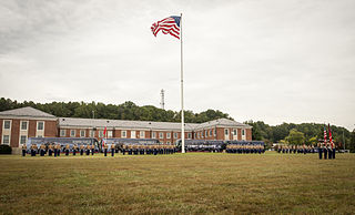
Marine Corps Base Quantico is a United States Marine Corps installation located near Triangle, Virginia, covering nearly 55,148 acres of southern Prince William County, Virginia, northern Stafford County, and southeastern Fauquier County. Used primarily for training purposes, MCB Quantico is known as the "Crossroads of the Marine Corps".

Prince William County Public Schools (PWCS) is a school division in Virginia with its headquarters in the Kelly Leadership Center located in the unincorporated community of Independent Hill in Prince William County, Virginia. As of the 2020 census, the population of the county was 486,943.

Southbridge is an unincorporated master-planned community of over 1,500 homes with more than 5,000 residents located in Prince William County, Virginia. It is situated on over 600 acres (2.4 km2) near the Potomac River on the Cherry Hill peninsula just north of the Town of Dumfries.

<span class="mw-page-title-main">Quantico Creek</span> River in Virginia, United States

<span class="mw-page-title-main">U.S. Route 1 in Virginia</span> Highway in Virginia

U.S. Route 1 (US 1) is a major north–south U.S. Route that serves the East Coast of the United States. In the U.S. state of Virginia, US 1 runs north–south through South Hill, Petersburg, Richmond, Fredericksburg, and Alexandria on its way from North Carolina to the 14th Street bridges into the District of Columbia. It is completely paralleled by Interstate Highways in Virginia—Interstate 85 (I-85) south of Petersburg, I-95 north to Alexandria, and I-395 into the District of Columbia—and now serves mainly local traffic. At its north end, on the approach to the 14th Street bridges, US 1 is concurrent with I-395; the rest of US 1 is on surface roads.

<span class="mw-page-title-main">Leesylvania State Park</span> State park in Prince William County, Virginia

Leesylvania State Park is located in the southeastern part of Prince William County, Virginia. The land was donated in 1978 by philanthropist Daniel K. Ludwig, and the park was dedicated in 1985 and opened full-time in 1992.

<span class="mw-page-title-main">County Center, Virginia</span> CDP in Virginia, United States

County Center is a census-designated place in Prince William County, Virginia, United States. The population as of the 2010 Census was 3,270. In 2021, the United States Census Bureau estimated it to be 4,045. It is notable for including the county's McCoart Government Center off Prince William Parkway, along with adjoining Pfitzner Stadium, former home field of the Potomac Nationals, now the Fredericksburg Nationals.

<span class="mw-page-title-main">Leesylvania, Virginia</span> Census-designated place in Virginia, United States

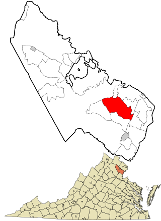
Leesylvania, formerly known as Neabsco, is a census-designated place in Prince William County in the U.S. state of Virginia.

<span class="mw-page-title-main">Virginia's 36th Senate district</span> American legislative district

Virginia's 36th Senate district is one of 40 districts in the Senate of Virginia. It has been represented by Democrat Scott Surovell since 2016, succeeding retiring fellow Democrat Toddy Puller.

<span class="mw-page-title-main">Powells Creek (Potomac River tributary)</span> Creek in Prince William County, Virginia, U.S.

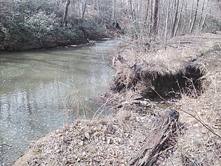
Powells Creek is a tributary of the lower tidal segment of the Potomac River in eastern Prince William County, Virginia, United States.

<span class="mw-page-title-main">Virginia State Route 610 (Prince William County)</span> Highway in Prince William County, Virginia

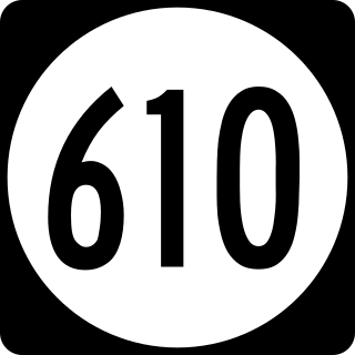
State Route 610 (SR 610) in Prince William County, Virginia, United States, is a 6.2-mile-long (10.0 km) secondary state highway officially named Cardinal Drive west of U.S. Route 1 (US 1) and Neabsco Road to the east. It acts as a major east–west thoroughfare through the southeastern area of Prince William County, acting as part of the boundary between the communities Dale City and Montclair as well as bisecting the community of Leesylvania.

Leesylvania was a plantation and historic home in Prince William County, Virginia, now part of Leesylvania State Park. During the 18th century, it was the home of Henry Lee II, his family and numerous slaves, and known for its productive land and especially the quality of its tobacco. Lee's sons Henry "Light-Horse Harry" Lee, Richard Bland Lee and Charles Lee, held prominent positions in Virginia during the American Revolutionary War and early federal government.

Linton Neck also known as Burbage's Neck is a peninsula in eastern Prince William County, Virginia bounded by the Occoquan River, Occoquan Bay, and Neabsco Creek. It is named after the prominent Linton family of the colonial era. Historically farmlands, today the plantation is home to a number of communities including: Featherstone, Woodbridge, Marumsco, and Neabsco. Near the fall line of the Occoquan River at the very North of Linton Neck is the incorporated town of Occoquan, Virginia. At the very south of Linton Neck is the historic site of Rippon Lodge.

Neabsco may refer to:

References

  1. Virginia Trend Report 2: State and Complete Places (Sub-state 2010 Census Data). Archived 2017-08-16 at the Wayback Machine Missouri Census Data Center. Accessed 2011-06-08.
  2. "Potomac Shores Living | Come Home to Parks and Trails". Potomac Shores. Retrieved August 19, 2021.
  3. "Leesylvania State Park". www.dcr.virginia.gov. Retrieved August 19, 2021.
  4. "Potomac Shores Canoe Club | The Place to Be on the River". Potomac Shores. Retrieved August 19, 2021.
  5. "Potomac Shores Life | New Ali Krieger Sports Complex". Potomac Shores. Retrieved August 19, 2021.
  6. "Potomac Shores Life | You're Bound to Love the Shores Club". Potomac Shores. Retrieved August 19, 2021.
  7. "Quantico, Virginia Travel Weather Averages (Weatherbase)". Weatherbase. Retrieved September 16, 2021.
  8. "Southbridge Community Association - Welcome Packet For Our Residents". www.southbridgeva.us. Retrieved September 16, 2021.
  9. "Potomac Local News - Local News for Prince William, Stafford, Manassas, Fredericksburg". Potomac Local News. Retrieved September 16, 2021.
  10. "The Southbridge, VA Sentinel". www.dittinc.com. Retrieved September 16, 2021.
  11. "Across Virginia Patch - Breaking News, Local News, Events, Schools, Weather, Sports and Shopping". Across Virginia, VA Patch. Retrieved September 16, 2021.