Administrative divisions of Norway

Last updated

Norway's elongated shape, its numerous internal geographical barriers and the often widely dispersed and separated settlements are all factors that have strongly influenced the structure of the country's administrative subdivisions. This structure has varied over time and is subject to continuous review. In 2017, the government decided to abolish some of the counties and to merge them with other counties to form larger ones, reducing the number of counties from 19 to 11, which was implemented on 1 January 2020. [1] Following protests, the new government decided to abolish three of the new counties in 2022, and re-establish seven of the old ones. Taking effect on 1. January 2024 there are fifteen counties in Norway.

Contents

Formal subdivisions

There are three levels of political administration in Norway:

As the infrastructure for travel and communication has improved over the years, so the benefits of further consolidation have remained under review. The number of municipalities has decreased from 744 in the early 1960s to today's 442, and more mergers are planned. Similarly, the political responsibilities of the counties have decreased, and there was talk earlier of combining them into 5–9 regions by 2010. Although those specific plans did not come to fruition, a similar scheme is again under consideration in 2018. [2]

Within the government administration, there are a few exceptions to the county subdivisions:

County

County municipality

A geopolitical map of Counties in Norway, exhibiting its 15 first-order subnational divisions (fylker or "counties") Fylkesinndeling2024 original.webp
A geopolitical map of Counties in Norway, exhibiting its 15 first-order subnational divisions (fylker or "counties")

A county municipality (Norwegian : Fylkeskommune) is the public elected body that is responsible for certain public administrative and service tasks within a county. Each county is governed as a county municipality, with the exception of Oslo, which is both a municipality and a county municipality. The main responsibility of the county municipalities are upper secondary schools, dental care, public transport, county roads, culture, cultural heritage management, land use planning and business development.

The main body of each county municipality is the county council (fylkesting), elected by direct election by all legal residents every fourth year. The county councils typically have 30-50 members and meet about six times a year. They are divided into standing committees and an executive board (fylkesutvalg), that meet considerably more often. Both the council and executive board are led by the Chairman of the County Council or County Mayor (fylkesordfører).

The national government, formally the King, is represented in each county by a county governor (Norwegian : Statsforvalter ). This office mainly functions as a supervising authority over the county and municipality administrations, and their decisions can be appealed to him.

Municipality

Municipalities are the atomic unit of local government and are responsible for primary education (through 10th grade), outpatient health services, senior citizen services, some social services, zoning, economic development, and municipal roads. Law enforcement and church services are provided at a national level in Norway. The main body of each municipality is the municipality council (kommunestyre), elected by direct election by all legal residents every fourth year.

Borough

Three municipalities, Oslo, Bergen and Stavanger, are divided into boroughs. In Oslo and Stavanger, they elect their own political council.[ citation needed ] They are part of the municipal organization, but have a certain amount of influence in issues regarding health, education and naming.

Integral territories

Svalbard (Norway) CIA map.gif
Svalbard
Jan Mayen (Norway) map.gif
Jan Mayen

Both Svalbard and Jan Mayen are "part of the Kingdom of Norway", although they are not allocated to a particular county and have not been declared as dependencies. [3] Svalbard and Jan Mayen is administered outside of the fylker system.

Dependencies

Norway has three dependent territories (Norwegian : biland), all uninhabited and located in the Southern Hemisphere. Bouvet Island is a Subantarctic island in the South Atlantic Ocean. [4] Queen Maud Land is a sector of Antarctica which spans between 20° west and 45° east. [5] Peter I Island is a volcanic island located 450 kilometres (280 mi) off the coast of Ellsworth Land of continental Antarctica. [6] Both Peter I Island and Queen Maud Land are south of 60°S and are thus part of the Antarctic Treaty System. While the treaty states that the claims are not affected by the treaty, only the other countries with claims recognize Norwegian sovereignty on the island. [7] The dependencies are administration by the Polar Affairs Department of the Ministry of Justice and the Police in Oslo. [8] Norwegian criminal law, private law and procedural law applies to the dependencies, in addition to other laws that explicitly state they are valid on the island. [9]

Informal subdivisions

Municipalities and counties of Norway Norway municipalities 2012 blank.svg
Municipalities and counties of Norway

Regions

Norway is generally divided into five regions (Norwegian : landsdel), which largely represent areas with a common language and culture: Northern Norway, Trøndelag, Western Norway, Southern Norway and Eastern Norway. Regions hold no official status in the government, but is used for organizing some public organizations, including the Norwegian Public Roads Administration and the regional health authorities. Central Norway is a region which consists of Trøndelag and Møre og Romsdal. Trøndelag and Northern Norway is collectively known as Nordenfjells. Sápmi is an area which spans into Sweden, Finland and Russia and is defined as the "homeland" of the Sami. The Norwegian Meteorological Institute uses different regions, corresponding to the weather patterns.

List of regions
RegionCounties
Northern Norway Nordland, Troms, Finnmark
Trøndelag Trøndelag
Western Norway Møre og Romsdal, Vestland, Rogaland
Southern Norway Agder
Eastern Norway Oslo, Akershus, Buskerud, Østfold, Vestfold, Telemark, Innlandet

Districts

Districts (Norwegian : distrikt) represent an unofficial area organized by common language, culture or geographical barriers. Their boundaries are subjective and some areas may be regarded as belonging to multiple districts. Districts are larger than municipalities and smaller than counties, although some districts may span across county borders. Some districts form a hierarchy where a district can be subdivided into multiple lesser districts.

Settlements and rural areas

Statistics Norway uses the term "settlement" for any collection of at least 200 people who live close together. Outside of these there may be rural areas which have an unofficial border. Sometimes these are defined by school districts. Cities are often divided into boroughs, which may or may not have[ clarification needed ]

History

Regions in Norway before 2019 Norwegian Regions.jpg
Regions in Norway before 2019

Municipal independence was established in 1838. The introduction of self-government in rural districts was a major political change. The Norwegian farm culture (bondekultur) that emerged came to serve as a symbol of national resistance to the forced union with Sweden. The legislation of 1837 gave both the towns and the rural areas the same institutions: a minor change for the town, but a major advance for the rural communities.

The composition and number of municipalities, their functions, and the existence and functions of the counties are being continuously debated. However, there are currently no plans for reform.

See also

Related Research Articles

<span class="mw-page-title-main">Antarctic Treaty System</span> International treaties concerning Antarctica

The Antarctic Treaty and related agreements, collectively known as the Antarctic Treaty System (ATS), regulate international relations with respect to Antarctica, Earth's only continent without a native human population. It was the first arms control agreement established during the Cold War, designating the continent as a scientific preserve, establishing freedom of scientific investigation, and banning military activity; for the purposes of the treaty system, Antarctica is defined as all the land and ice shelves south of 60°S latitude. Since September 2004, the Antarctic Treaty Secretariat, which implements the treaty system, is headquartered in Buenos Aires, Argentina.

<span class="mw-page-title-main">Geography of Norway</span>

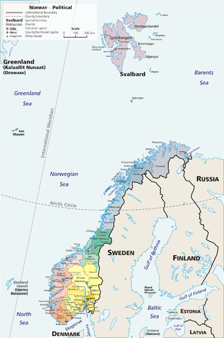
Norway is a country located in Northern Europe in the northern and western parts of the Scandinavian Peninsula. The majority of the country borders water, including the Skagerrak inlet to the south, the North Sea to the southwest, the North Atlantic Ocean to the west, and the Barents Sea to the north. It has a land border with Sweden to the east; to the northeast it has a shorter border with Finland and an even shorter border with Russia.

The politics of Norway take place in the framework of a parliamentary, representative democratic constitutional monarchy. Executive power is exercised by the Council of State, the cabinet, led by the prime minister of Norway. Legislative power is vested in both the government and the legislature, the Storting, elected within a multi-party system. The judiciary is independent of the executive branch and the legislature.

<span class="mw-page-title-main">Peter I Island</span> Island in Antarctica

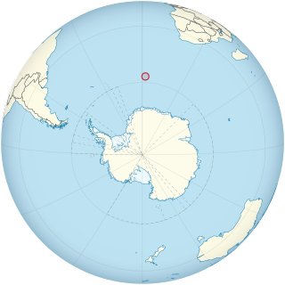
Peter I Island is an uninhabited volcanic island in the Bellingshausen Sea, 450 kilometres (240 nmi) from continental Antarctica. It is claimed as a dependency of Norway and, along with Bouvet Island and Queen Maud Land, composes one of the three Norwegian dependent territories in the Antarctic and Subantarctic. The island measures approximately 11 by 19 kilometres, with an area of 156 km2 (60 sq mi); its highest point is the ultra-prominent, 1,640-metre-tall (5,380 ft) Lars Christensen Peak. Nearly all the island is covered by a glacier, and it is surrounded most of the year by pack ice, making it inaccessible during these times. There is little vertebrate animal life on the island, apart from some seabirds and seals.

A dependent territory, dependent area, or dependency is a territory that does not possess full political independence or sovereignty as a sovereign state, yet remains politically outside the controlling state's integral area.

<span class="mw-page-title-main">Counties of Norway</span> First-level administrative divisions of Norway

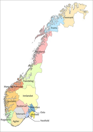
Norway is divided into 15 administrative regions, called counties which until 1918 were known as amter. The counties form the first-level administrative divisions of Norway and are further subdivided into 356 municipalities. The island territories of Svalbard and Jan Mayen are outside the county division and ruled directly at the national level. The capital Oslo is both a county and a municipality.

<span class="mw-page-title-main">Svalbard and Jan Mayen</span> Two parts of Norway under separate jurisdictions

Svalbard and Jan Mayen is a statistical designation defined by ISO 3166-1 for a collective grouping of two remote jurisdictions of Norway: Svalbard and Jan Mayen. While the two are combined for the purposes of the International Organization for Standardization (ISO) category, they are not administratively related. This has further resulted in the country code top-level domain .sj being issued for Svalbard and Jan Mayen, and ISO 3166-2:SJ. The United Nations Statistics Division also uses this code, but has named it the Svalbard and Jan Mayen Islands.

The extreme points of Norway include the coordinates that are farther north, south, east or west than any other location in Norway; and the highest and the lowest altitudes in the country. The northernmost point is Rossøya on Svalbard, the southernmost is Pysen in Mandal, the easternmost is Kræmerpynten on Svalbard, and the westernmost is Hoybergodden on Jan Mayen. The highest peak is Galdhøpiggen, standing at 2,469 m (8,100 ft) above mean sea level, while the lowest elevation is sea level at the coast.

<span class="mw-page-title-main">Norwegian Polar Institute</span> Norwegian government agency

The Norwegian Polar Institute is Norway's central governmental institution for scientific research, mapping and environmental monitoring in the Arctic and the Antarctic. The NPI is a directorate under Norway's Ministry of Climate and Environment. The institute advises Norwegian authorities on matters concerning polar environmental management and is the official environmental management body for Norwegian activities in Antarctica.

<span class="mw-page-title-main">UTC+01:00</span> Identifier for a time offset

UTC+01:00 is an identifier for a time offset from UTC of +01:00. In ISO 8601, the associated time would be written as 2019-02-07T23:28:34+01:00. This time is used in:

<span class="mw-page-title-main">Politics of Svalbard</span> Political system of Svalbard

Svalbard lies under the sovereignty of Norway, but the Svalbard Treaty places several restrictions. Norway cannot use the archipelago for warlike purposes, cannot discriminate economic activity based on nationality and is required to conserve the natural environment. Uniquely, Svalbard is an entirely visa-free zone. Everybody may live and work in Svalbard indefinitely regardless of country of citizenship. Svalbard Treaty grants treaty nationals equal right of abode as Norwegian nationals. Non-treaty nationals may live and work indefinitely visa-free as well. "Regulations concerning rejection and expulsion from Svalbard" is in force on non-discriminatory basis.

<span class="mw-page-title-main">Troll (research station)</span> Antarctic base

Troll is a Norwegian research station located at Jutulsessen, 235 kilometres (146 mi) from the coast in the eastern part of Princess Martha Coast in Queen Maud Land, Antarctica. It is Norway's only all-year research station in Antarctica, and is supplemented by the summer-only station Tor. Troll is operated by the Norwegian Polar Institute and also features facilities for the Norwegian Meteorological Institute and the Norwegian Institute for Air Research.

<span class="mw-page-title-main">Outline of Norway</span> Overview of and topical guide to Norway

The following outline provides an overview of, and topical guide to, the Kingdom of Norway.

<span class="mw-page-title-main">Territorial claims in Antarctica</span> Land claims of the continent

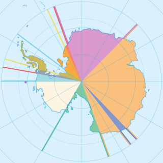
Seven sovereign states – Argentina, Australia, Chile, France, New Zealand, Norway, and the United Kingdom – have made eight territorial claims in Antarctica. These countries have tended to place their Antarctic scientific observation and study facilities within their respective claimed territories; however, a number of such facilities are located outside of the area claimed by their respective countries of operation, and countries without claims such as China, India, Italy, Japan, Pakistan, Russia, South Africa (SANAE), Ukraine, and the United States have constructed research facilities within the areas claimed by other countries. There are overlaps among the territories claimed by Argentina, Chile, and the United Kingdom.

<span class="mw-page-title-main">Bouvet Island</span> Uninhabited volcanic island and dependency of Norway in the South Atlantic Ocean

Bouvet Island is an island and dependency of Norway, and declared an uninhabited protected nature reserve. It is a subantarctic volcanic island, situated in the South Atlantic Ocean at the southern end of the Mid-Atlantic Ridge, making it the world's most remote island. It is not part of the southern region covered by the Antarctic Treaty System.

<span class="mw-page-title-main">Regions of Norway</span> Geographical division in Norway

Norway is commonly divided into five major geographical regions. These regions are purely geographical, and have no administrative purpose. However, in 2017 the government decided to abolish the current counties of Norway and to replace them with fewer, larger administrative regions. The first of these new areas came into existence on 1 January 2018, when Nord-Trøndelag and Sør-Trøndelag merged to form Trøndelag.

<span class="mw-page-title-main">Queen Maud Land</span> Norways territorial claim in Antarctica

Queen Maud Land is a roughly 2.7-million-square-kilometre (1.0-million-square-mile) region of Antarctica claimed by Norway as a dependent territory. It borders the claimed British Antarctic Territory 20° west and the Australian Antarctic Territory 45° east. In addition, a small unclaimed area from 1939 was annexed in June 2015. Positioned in East Antarctica, it makes out about one-fifth of the continent, and is named after the Norwegian queen Maud of Wales (1869–1938).

<span class="mw-page-title-main">Dependencies of Norway</span> Territories of Norway in the Southern Hemisphere

Norway has three dependent territories, all uninhabited and located in the Southern Hemisphere. Bouvet Island (Bouvetøya) is a sub-Antarctic island in the South Atlantic Ocean. Queen Maud Land is the sector of Antarctica between the 20th meridian west and the 45th meridian east. Peter I Island is a volcanic island located 450 kilometres (280 mi) off the coast of Ellsworth Land of continental Antarctica. Despite being unincorporated areas, neither Svalbard nor Jan Mayen is formally considered a dependency. While the Svalbard Treaty regulates some aspects of that Arctic territory, it acknowledges that the islands are part of Norway. Similarly, Jan Mayen is recognized as an integral part of Norway.

<span class="mw-page-title-main">ISO 3166-2:SJ</span> Entry for Svalbard and Jan Mayen in ISO 3166-2

ISO 3166-2:SJ is the entry for Svalbard and Jan Mayen in ISO 3166-2, part of the ISO 3166 standard published by the International Organization for Standardization (ISO). The standard defines codes for names of principal subdivisions of all countries coded in ISO 3166-1. Svalbard and Jan Mayen does not exist as an administrative region, but rather consists of two separate parts of Norway under separate jurisdictions—Svalbard and Jan Mayen. Further subdivision for Svalbard and Jan Mayen occurs under Norway's entry, ISO 3166-2:NO, namely NO-21 for Svalbard and NO-22 for Jan Mayen. There are currently no ISO 3166-2 codes for Svalbard and Jan Mayen.

References

  1. "Dette er Norges nye regioner". vg.no. 21 February 2017. Archived from the original on 9 March 2018. Retrieved 28 April 2018.
  2. Notwegian government website: Regionreform (in Norwegian)
  3. Arlov, Thor B. (1994). A short history of Svalbard. Oslo: Norwegian Polar Institute. p. 68. ISBN   82-90307-55-1.
  4. "Svalbard". The World Factbook . Central Intelligence Agency. 11 April 2012. Retrieved 25 April 2012.
  5. "Dronning Maud Land" (in Norwegian). Norwegian Polar Institute. Archived from the original on 21 July 2012. Retrieved 10 May 2011.
  6. "Peter I Øy". Norwegian Climate and Pollution Agency. Archived from the original on 28 September 2011. Retrieved 29 August 2011.
  7. "The Antarctic Treaty". Secretariat of the Antarctic Treaty. Archived from the original on 15 April 2008. Retrieved 29 August 2011.
  8. "Polar Affairs Department". Norwegian Ministry of the Environment. Archived from the original on 8 August 2011. Retrieved 29 August 2011.
  9. "Lov om Bouvet-øya, Peter I's øy og Dronning Maud Land m.m. (bilandsloven)" (in Norwegian). Lovdata. Archived from the original on 2 December 2013. Retrieved 29 August 2011.