Administrative divisions of the Ukrainian Soviet Socialist Republic

Last updated

During its existence from 1919 to 1991, the Ukrainian Soviet Socialist Republic consisted of many administrative divisions. Itself part of the highly centralized Soviet Union, sub-national divisions in the Ukrainian SSR were subordinate to higher executive authorities and derived their power from them. Throughout the Ukrainian SSR's history, other national subdivisions were established in the republic, including guberniyas and okrugs, before finally being reorganized into their present structure as oblasts. At the time of the Ukrainian SSR's independence from the Soviet Union, the country was composed of 25 oblasts (provinces) and two cities with special status, Kiev, the capital, and Sevastopol, respectively.

Contents

Background

Prior to the First World War, most of the Ukrainian lands were integrated into the Imperial Russian structure of guberniyas (Governorate) which in turn split into uezds and volosts. The map to the right shows the outline of the governorates with regard to modern division of Ukraine. These included Volhynia, Podolia, Kiev, Poltava, Kharkov and Taurida, Kherson, Yekaterinoslav, the larger part of Chernigov Governorate, small parts of Bessarabia, Kursk and Don Host Oblast, and bordering regions of the Minsk and Orel Governorates. The structure has remained stable throughout the 19th century, with minor variations. In 1912, and additional Kholm Governorate was formed out of Vistula Land and passed to the Southwestern Krai.

Ukraine's modern border superimposed on the administrative division of 1900 for both the Russian and the Austro-Hungarian Empires. 1900 Ukr adm podil.png
Ukraine's modern border superimposed on the administrative division of 1900 for both the Russian and the Austro-Hungarian Empires.

After the February Revolution in Petrograd, the Central Council of Ukraine was proclaimed in Kyiv, initially as an autonomous entity within future Russia. The Russian Provisional Government recognised the competency of this administration of only five Ukrainian governorates: Kyiv, Chernigov, Poltava, Podolia and Volhynia.

The 1918 Ukrainian administrative territorial reform UNR 1918 divisions-0.png
The 1918 Ukrainian administrative territorial reform
Administrative territorial division of Ukraine after abortion of the reform Ukrainian State 1918 divisions.png
Administrative territorial division of Ukraine after abortion of the reform

With the Communist October Revolution and fall of the Provisional Government, the Central Council government extended its claims to all nine governorates where according to the 1897 Russian Census more population was Ukrainophone. After several failed attempts to take power in Kyiv and despite holding cease fire negotiations with Central Powers, Bolsheviks sent an expeditionary force of Vladimir Antonov-Ovseyenko to overthrow the government of the Central Council. The Central Council in its turn appealed for military support to the Central Powers to stop the Russian invasion during which number of Soviet puppet states sprung across the whole Ukraine such as Odesa Soviet Republic and Donetsk-Krivoy Rog Soviet Republic eventually re-uniting in March 1918 into a single Ukrainian Soviet Republic.

With help of the German Army, Ukrainian forces managed to remove the Russian occupation forces. The Ukrainian government attempted to implement its own administrative territorial reform by reviving the long forgotten Ukrainian term zemlia which would replace the system of governorates and counties (uyezd). On March 6, 1918, the Central Council of Ukraine passed the law to start the reform. By the end of April however, Pavlo Skoropadsky with the help of German military administration in Kyiv caused a coup d'état establishing the Hetmanate. The reform that lasted less than for two months was aborted. The previous governorates were returned, while certain changes took places in regards to borders. The Kharkov Governorate was enlarged eastward overtaken territories of the east Sloboda Ukraine. In place of "continental" part Taurida Governorate, there was created the Taurida Okruha (district). Ukraine also received southern portions of the Belarusian governorates creating the Polissia Okruha.

Governorates

Administrative divisions in 1921 consisted of Huberniias and povits. Uezd Gubernia Ukraine 1921.jpg
Administrative divisions in 1921 consisted of Huberniias and povits.

Until the Riga Peace Treaty with Poland on 18 March 1921 the Ukrainian SSR had the governmental administrative division of Imperial Russia and consisted of ten guberniyas. That administrative division was confirmed during the establishment of the Ukrainian State in 1918 when the Red Army withdrew from Ukraine following the Treaty of Brest-Litovsk with Central Powers.

  1. Chernihiv Governorate
  2. Katerynoslav Governorate
  3. Kharkiv Governorate
  4. Kherson Governorate, later reformed into Odessa Governorate
  5. Kyiv Governorate
  6. Podolia Governorate
  7. Poltava Governorate
  8. Volhynian Governorate

In 1920-1921 series of territorial changes took place as well as changing in administrative division.

16 April 1920
18 March 1921 (Peace of Riga)
21 October 1922

Okruhas

Oblasts

Subdivisions in 1953, pictured with 25 oblasts; Crimea would be transferred in 1954 and the Drohobych and Izmail oblasts would be absorbed by the Lviv and Odessa oblasts respectively. Ukraine 1946-1954.png
Subdivisions in 1953, pictured with 25 oblasts; Crimea would be transferred in 1954 and the Drohobych and Izmail oblasts would be absorbed by the Lviv and Odessa oblasts respectively.

Initial development

The raion system proved very difficult to administer wholly, and on February 27, 1932, they were grouped into five oblasts, though Moldovan ASSR was kept:

The latter three were soon partitioned in the same year to create the following two oblasts:

It was during this configuration, that Ukraine underwent the first two five-year plans, (a consequence of which was the catastrophic Holodomor famine in 1933), and the collectivization and industrialization that they brought. In 1934 the capital moved to Kyiv, and on 30 January 1937, the Supreme Rada of the Ukrainian Socialist Soviet Republic adopted its version of the 1936 Soviet Constitution creating the Ukrainian Soviet Socialist Republic. To meet the economic and social demands, a restructure in the administrative division was initiated, and 22 September 1937 four more oblasts were added to the existing seven.

As the Donbas continued to grow both industrially and in population, on 3 July 1938, the Donetsk Oblast was effectively split into two:

In a further re-structure 10 January 1939 the twelve existing oblasts and one republic were joined by a further three:

Start of World War II

After the Soviet invasion of Poland and the resulting annexation of its eastern half by the Soviet Union. The territorial administration was somewhat preserved converting Polish voivodeships into Soviet oblasts. Thus, six new oblasts were established in Western Ukraine on 4 December 1939:

In late June 1940 the Soviet Union annexed Bessarabia and Northern Bukovina from the Kingdom of Romania. On the 28th of June 1940, the Moldavian SSR, a full Union republic was formed out of most of Bessarabia and Moldavian ASSR that Ukraine gave up. In return it gained the Northern Bukovina province and the southern Budjak region from Bessarabia. The new territories were integrated into Ukraine on 7 August 1940, as respectively:

The former was renamed to Izmail Oblast on 7 December 1940, and the centre moved to Izmail. Thus, in the prelude of Soviet Union's entry to World War II, Ukraine gained eight new Oblasts, which combined with the fifteen existing previously, brought a total to twenty three.

German occupation

As the Red Army liberated Ukraine throughout 1943/1944, several changes were made, including the complete reinstatement of the pre-World War II oblasts. On 29 March 1944 the city of Chernivitsi was renamed to Chernivtsi, as was the oblast. In a similar fashion, Tarnopil became Ternopil on 15 April 1944.

The liberation left a German-occupied zone in Crimea and Taurida. To facilitate the Crimean Offensive, on 30 March 1944, a new, 24th oblast was created in Taurida:

Post World War II

After the war ended, the Carpathian Ruthenia province of Czechoslovakia was passed to the USSR and on 21 January 1946, the territory was annexed to Ukraine as the

During the post-war rebuilding the administrative division remained stable. However the political aftermath following death of Stalin in 1953 brought a number of re-organisation policies into Ukraine. Already, on 7 January 1954, a new entity was created in central Ukraine via donation of bordering raions from neighbouring oblasts, called

In the prelude to the 300th anniversary of the Treaty of Pereyaslavl on 4 February, the city of Proskuriv was renamed to Khmelnytskyi, after the historic Cossack leader Bohdan Khmelnytskyi, along with the oblast. On 19 February the Izmail Oblast was disbanded and merged with the Odessa Oblast. However, arguably the most significant change in 1954 was the transfer of Crimea from the Russian SFSR, and thus Ukraine gained the

After the political defeat of the so-called Anti-Party Group, consisting of famous politicians such as Vyacheslav Molotov and Lazar Kaganovich, a nationwide renaming campaign was undertaken. To ensure further disturbances of such manner be avoided, in early 1958 Moscow passed a decree not to name any object or locale in honour of a living person, and on 5 March 1958, the city of Voroshylovhrad (bearing the name of its native, Kliment Voroshilov) was renamed to its historical name of Luhansk as was the oblast.

Drohobych Oblast was continuously reduced in size, ceding three raions to the Polish Committee of National Liberation in autumn 1944 (including the city of Peremyshl). Another raion (village of Medyka) followed in May 1948, and losing a further 480 km² of territory in 1951 to the now People's Republic of Poland. The rural oblast also proved to be economically inefficient and was thus disbanded; its territory merged into Lviv Oblast on 21 May 1959. The latter would be the last major change of internal borders of Ukraine's administrative divisions until present day, the oblast count would stay stable at twenty five up to the republic's independence in 1991.

Minor changes would continue nonetheless. The 22nd Congress of the CPSU initiated a cosmetic phase to the De-Stalinization programme by breaking Joseph Stalin's cult of personality. On 9 November 1961, the city of Stalino was renamed to Donetsk and the oblast followed suit. Exactly a year later, the city and oblast of Stanislaviv was renamed to Ivano-Frankivsk in honour of the Ukrainian writer and poet Ivan Franko. Following the death of Kliment Voroshilov in December 1969, the city and oblast of Luhansk once again became Voroshylovhrad on 5 January 1970.

This arrangement would enter a stable phase right into perestroika. On 4 May 1990 Voroshylovhrad would be renamed to Luhansk, along with the oblast. On 11 June 1991, the city of Rovno was renamed to Rivne, the oblast too. However, the most significant change took place on June 19 1991, when the Crimean Oblast would re-establish as the Crimean Autonomous Soviet Socialist Republic, which it held as part of the Russian SFSR until 18 May 1944, and would declare sovereignty on 4 September.

The present Administrative division of Ukraine have retained the Soviet-time arrangement, though legal formalities such as the Crimea's status as an Autonomous republic and the status of Sevastopol would be settled in the mid-1990s. However, Crimea would be eventually annexed forcibly into Russia in 2014 while four Ukrainian oblasts of Kherson, Zaporizhzhia, Donetsk and Luhansk were also illegally annexed into Russia in September 2022. The pro-Russian states of Donetsk People's Republic and Luhansk People's Republics unilaterally declared independence from Ukraine in 2014.

See also

Related Research Articles

<span class="mw-page-title-main">Historical regions in present-day Ukraine</span> List of historical regions in Ukraine

This is a list of historical regions in present-day Ukraine.

<span class="mw-page-title-main">Donetsk Oblast</span> Oblast (region) of Ukraine

Donetsk Oblast, also referred to as Donechchyna (Донеччина), is an oblast in eastern Ukraine. It is Ukraine's most populous province, with around 4.1 million residents. Its administrative centre is Donetsk, though due to the ongoing Russo-Ukrainian War, the regional administration was moved to Kramatorsk. Historically, the region has been an important part of the Donbas region. From its creation in 1938 until November 1961, it bore the name Stalino Oblast as Donetsk was then named "Stalino". As part of the de-Stalinization process, it was renamed after the Siversky Donets river, the main artery of Eastern Ukraine. Its population is estimated as 4,100,280

<span class="mw-page-title-main">Kharkiv Oblast</span> Oblast (region) of Ukraine

Kharkiv Oblast, also referred to as Kharkivshchyna (Харківщина), is an oblast (province) in eastern Ukraine. The oblast borders Russia to the north, Luhansk Oblast to the east, Donetsk Oblast to the south-east, Dnipropetrovsk Oblast to the south-west, Poltava Oblast to the west and Sumy Oblast to the north-west. The area of the oblast is 31,400 square kilometres (12,100 sq mi), corresponding to 5.2% of the total territory of Ukraine.

A governorate, gubernia, province, or government, was a major and principal administrative subdivision of the Russian Empire. After the Bolshevik Revolution in 1917, governorates remained as subdivisions in Belarus, Russia, Ukraine, and in the Soviet Union from its formation until 1929. The term is also translated as government, governorate, or province. A governorate was headed by a governor, a word borrowed from Latin gubernator, in turn from Greek κυβερνήτης.

<span class="mw-page-title-main">Oblasts of Russia</span> Administrative division of Russia

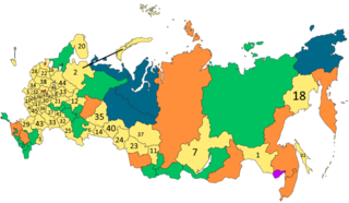
An oblast is a type of federal subject in Russia.

<span class="mw-page-title-main">Administrative divisions of Ukraine</span> Political divisions of Ukraine

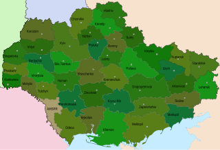
The administrative divisions of Ukraine are under the jurisdiction of the Ukrainian Constitution. Ukraine is a unitary state with three levels of administrative divisions: 27 regions, 136 raions and 1469 hromadas.

<span class="mw-page-title-main">Oblasts of Ukraine</span> Type of first-level administrative division of Ukraine

An oblast in Ukraine, sometimes translated as region or province, is the main type of first-level administrative division of the country. Ukraine's territory is divided into 24 oblasts, as well as one autonomous republic and two cities with special status. Ukraine is a unitary state, thus the oblasts do not have much legal scope of competence other than that which is established in the Ukrainian Constitution and by law. Articles 140–146 of Chapter XI of the constitution deal directly with local authorities and their competency.

<span class="mw-page-title-main">Taurida Governorate</span> 1802–1921 governorate of the Russian Empire

The Taurida Governorate was a historical governorate of the Russian Empire. It included the Crimean Peninsula and the mainland between the lower Dnieper River and the coasts of the Black Sea and Sea of Azov. It was formed after the Taurida Oblast was abolished in 1802 in the course of Paul I's administrative reform of the territories of the former Crimean Khanate that was annexed by the Russian Empire in 1783. The governorate's centre was the city of Simferopol. The province was named after the ancient Greek name of Crimea - Taurida.

<span class="mw-page-title-main">Kherson Governorate</span> 1802–1920 guberniya of the Russian Empire

The Kherson Governorate was an administrative territorial unit of the Russian Empire located between the Dnieper and Dniester Rivers. It was one of three governorates created in 1802 when Novorossiya Governorate was abolished. It was known as the Mykolaiv or Nikolayev Governorate until 1803, when Nikolayev was separated into a special Nikolayev War Governorate as a center of the Black Sea Fleet and the governor seat was moved to Kherson.

<span class="mw-page-title-main">Yekaterinoslav Governorate</span> 1802–1925 governorate of the Russian Empire and Soviet Union

The Yekaterinoslav Governorate, also known by Ukrainian common name Katerynoslavshchyna, was a governorate of the Russian Empire, with its capital located in Yekaterinoslav. The governorate covered 63,392 square kilometres (24,476 sq mi) of area, and was composed of the inhabitant of 2,113,674 by the census of 1897. The Yekaterinoslav Governorate bordered the Poltava Governorate to the north, the Don Host Oblast to the east, the Sea of Azov to the southeast, the Taurida Governorate to the south, and the Kherson Governorate to the east, and covered the area of the Luhansk, Donetsk, Dnipropetrovsk, and Zaporizhzhia Oblasts of Ukraine.

<span class="mw-page-title-main">Poltava Governorate</span> Governorate in Russian Empire

The Poltava Governorate or Poltavshchyna was a gubernia in the historical Left-bank Ukraine region of the Russian Empire. It was officially created in 1802 from the disbanded Malorossiya Governorate, which was split between the Chernigov Governorate and Poltava Governorate with an administrative center of Poltava.

<span class="mw-page-title-main">Kharkov Governorate</span> Governorate of Russian Empire in modern Ukraine

The Kharkov Governorate was a governorate of the Russian Empire founded in 1835. It embraced the historical region of Sloboda Ukraine. From 1765 to 1780 and from 1796 to 1835 the governorate was called the Sloboda Ukraine Governorate. In 1780-1796 there existed the Kharkov Viceroyalty.

<span class="mw-page-title-main">Novorossiya Governorate</span> 1764–1783 governorate of the Russian Empire in eastern Ukraine

Novorossiya Governorate, was a governorate of the Russian Empire in the previously Ottoman and Cossack territories, that existed from 1764 until the 1783 administrative reform. It was created and governed according to the "Plan for the Colonization of New Russia Governorate" issued by the Russian Senate. It became the first region in Russia where Catherine the Great allowed foreign Jews to settle.

<span class="mw-page-title-main">Development of the administrative divisions of Ukraine</span>

Administrative divisions development in Ukraine reviews the history of changes in the administrative divisions of Ukraine, in chronological order.

<span class="mw-page-title-main">Okruhas of the Ukrainian Soviet Socialist Republic</span> Defunct transitional administrative divisions of the Ukrainian Soviet Socialist Republic (1923–1930)

An okruha is an historical administrative division of the Ukrainian Soviet Socialist Republic that existed between 1923 and 1930. The system was intended as a transitional system between the Russian Imperial division of governorates and the modern equivalent of oblasts.

Censuses in Ukraine is a sporadic event that since 2001 has been conducted by the State Statistics Committee of Ukraine under the jurisdiction of the Government of Ukraine.

<span class="mw-page-title-main">Administrative divisions of Ukraine (1918–1925)</span>

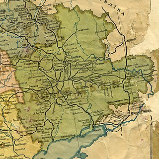
The administrative division of Ukraine in 1918 was inherited from the Russian Empire, and based on the largest unit of the gubernia with smaller subdivisions county or district, and rural district.

<span class="mw-page-title-main">Donets Governorate</span>

Donets Governorate was a governorate of the Ukrainian SSR (Ukraine) that existed between 1919 and 1925.

<span class="mw-page-title-main">Novorossiya</span> Territory of the Russian Empire (1764–1917)

Novorossiya, literally "New Russia", is a historical name, used during the era of the Russian Empire for an administrative area that would later become the southern mainland of Ukraine: the region immediately north of the Black Sea and Crimea. The province fell largely within a slightly wider area known in Ukrainian as the Stepovyna "Steppe Land", or Nyz "Lower Land". The name Novorossiya entered official usage in 1764, after the Russian Empire conquered the Crimean Khanate, and annexed its territories, when Novorossiya Governorate was founded. Official usage of the name ceased after 1917, when the entire area was incorporated in the Ukrainian People's Republic.

References