
John Rennie was a Scottish civil engineer who designed many bridges, canals, docks and warehouses, and a pioneer in the use of structural cast-iron.
Holyhead is the largest town and a community in the county of Isle of Anglesey, Wales, with a population of 13,659 at the 2011 census. Holyhead is on Holy Island, bounded by the Irish Sea to the north, and is separated from Anglesey island by the narrow Cymyran Strait and was originally connected to Anglesey via the Four Mile Bridge.

Holy Island is an island on the western side of the larger Isle of Anglesey, Wales, from which it is separated by the Cymyran Strait. It is called "Holy" because of the high concentration of standing stones, burial chambers, and other religious sites on the small island. The alternative English name of the island is Holyhead Island. According to the 2011 UK Census, the population was 13,659, of whom 11,431 (84%) lived in the largest town, Holyhead.

The A5, the London-Holyhead trunk road, is a major road in England and Wales. It runs for about 243 miles (391 km) from London to the Irish Sea at the ferry port of Holyhead. In many parts the route follows that of the Roman Iter II route which later took the Anglo-Saxon name Watling Street.
Red Wharf Bay, also known as Traeth Coch, is a village and a wide sandy bay in the Anglesey Area of Outstanding Natural Beauty on the east coast of the island of Anglesey in Wales. The bay lies between the villages of Pentraeth and Benllech. It is also close to Castell Mawr Rock, thought to be the site of an Iron Age fort.
Salt Island is joined to Holy Island, Anglesey, in North Wales. It is a natural provider of shelter for the town's Old Harbour from the Irish Sea and is part of the Port of Holyhead.
HMY Mary was the first Royal Yacht of the Royal Navy. She was built in 1660 by the Dutch East India Company. Then she was purchased by the City of Amsterdam and given to King Charles II, on the restoration of the monarchy, as part of the Dutch Gift. She struck rocks off Anglesey in thick fog on 25 March 1675 while en route from Dublin to Chester. Although 35 of the 74 crew and passengers were killed as the wreck quickly broke up, 39 managed to get to safety. The remains were independently discovered by two different diving groups in July 1971. After looters started to remove guns from the site, a rescue operation was organized and the remaining guns and other artifacts were taken to the Merseyside Museums for conservation and display. After the passing of the Protection of Wrecks Act 1973, she was designated as a protected site on 20 January 1974.

The City of Dublin Steam Packet Company was a shipping line established in 1823. It served cross-channel routes between Britain and Ireland for over a century. For 70 of those years it transported the mail. It was 'wound-up' by a select committee of the House of Lords in 1922 and finally liquidated in 1930.
Rochdale and Prince of Wales were two troop ships that sank in Dublin Bay in 1807.

The Holyhead Mountain Hut Circles named in Welsh: Tŷ Mawr / Cytiau'r Gwyddelod, literally meaning Big house or "Irishmen's Huts". are the remains of a group of Celtic Iron Age huts near Trearddur on Holy Island, Anglesey, Wales. The site is under the care of Cadw and can be visited all year round. The construction of these huts is very similar to those at Din Lligwy, having thick stone walls.

The Isle of Anglesey is a county off the north-west coast of Wales. It is named after the island of Anglesey, which makes up 94% of its area, but also includes Holy Island and some islets and skerries. The county borders Gwynedd across the Menai Strait to the southeast, and is otherwise surrounded by the Irish Sea. Holyhead is the largest town, and the administrative centre is Llangefni. The county is part of the preserved county of Gwynedd.

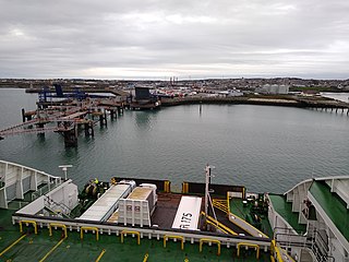
The Port of Holyhead is a commercial and ferry port in Anglesey, United Kingdom, handling more than 2 million passengers each year. It covers an area of 240 hectares, and is operated by Stena Line Ports Ltd. The port is the principal link for crossings from north Wales and central and northern England to Ireland. The port is partly on Holy Island and partly on Salt Island. It is made up of the Inner Harbour, the Outer Harbour and the New Harbour, all sheltered by the Holyhead Breakwater which, at 2.7 kilometres, is the longest in the UK.
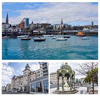
Dún Laoghaire is a suburban coastal town in County Dublin in Ireland. It is the administrative centre of the county of Dún Laoghaire–Rathdown. The town was built up alongside a small existing settlement following 1816 legislation that allowed the building of a major port to serve Dublin. It was known as Dunleary until it was renamed Kingstown in honour of King George IV's 1821 visit, and in 1920 was given its present name, the original Irish form from which "Dunleary" was anglicised. Over time, the town became a residential location, a seaside resort, the terminus of Ireland's first railway and the administrative centre of the former borough of Dún Laoghaire, and from 1994, of the county of Dún Laoghaire–Rathdown.

Holyhead Breakwater is situated at the north-western end of Holyhead in Anglesey in North Wales. The Victorian structure, which is 1.7 miles (2.7 km) long, is the longest breakwater in the United Kingdom. The breakwater, which is accessible in good weather, has a promenade on top which leads out to the Holyhead Breakwater Lighthouse.

Cylch-y-Garn is a community in Anglesey, Wales, located on the north west coast of the county, 9.0 miles (14.5 km) west of Amlwch, 12.5 miles (20.1 km) north east of Holyhead and 15.0 miles (24.1 km) north west of Llangefni. It includes the villages of Llanfair-yng-Nghornwy, Llanrhyddlad and Rhydwyn, plus Llanrhwydrys, Caerau and Cemlyn. the north west tip of the island at Carmel Head, and the offshore islands of the Skerries and West Mouse. At the 2001 census the community had a population of 675, increasing to 758 at the 2011 census.
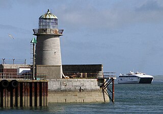
Holyhead Mail Pier or Admiralty Pier Lighthouse on Salt Island, Anglesey, is an inactive lighthouse which was designed by the civil engineer John Rennie in 1821. It was built in the early 19th century to help guide shipping into the newly constructed harbour, now known as the Port of Holyhead, which acted as the terminus for the packet service between England and Ireland. It is probably the second oldest lighthouse in Wales, after Point of Ayr Lighthouse and is the last of a series of three lighthouses located on Salt Island.

St Mihangel's Church in the village of Llanfihangel yn Nhowyn is a former parish church now used as the chapel for RAF Valley in Anglesey, north Wales. The date of the first church on the site is uncertain, but in 1862 the then-existing church was rebuilt. St Mihangel's became the chapel for the nearby Royal Air Force base in 1998, after the Church in Wales had ceased using it for services. It was then extended by dismantling and reassembling another Anglesey church, St Enghenedl's, at the west end of the building.

In the United Kingdom, the term listed building refers to a building or other structure officially designated as being of special architectural, historical, or cultural significance; Grade II* structures are those considered to be "particularly important buildings of more than special interest". Listing was begun by a provision in the Town and Country Planning Act 1947. Once listed, strict limitations are imposed on the modifications allowed to a building's structure or fittings. In Wales, the authority for listing under the Planning Act 1990 rests with Cadw.

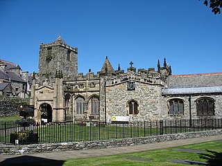
Eglwys y Bedd is all that remains of a 14th-century church in Anglesey, north Wales. It is set within the churchyard of St Cybi's, Holyhead, and may have been built on the site where Cybi lived and ministered. It is reputed to house the grave of Seregri, an Irish warrior who lived in the area in the 5th century.
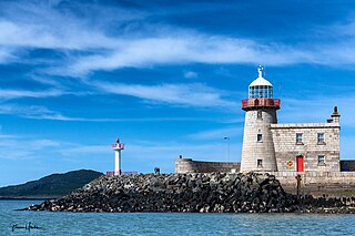
The Harbour lighthouse in Howth is a historic aid to navigation situated on the East pier of the harbour. It was built in the early 19th century to help guide shipping into the newly constructed harbour, which acted as the terminus for the packet service between Ireland and England. In 1982 it was decommissioned and replaced by a modern pole light on an adjacent extension of the pier.

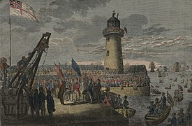 George IV arriving at Holyhead, 7 August 1821
 George IV on board the 'Lightning' en route to Dublin, 12 August 1821
 A plan of the triumphal arch, pier and lighthouse

