Aeolian landform

Last updated

Aeolian landforms are produced by either the erosive or depositive action of wind. These features may be built up from sand or snow, [1] or eroded into rock, snow, or ice.

Contents

Aeolian landforms are commonly observed in sandy deserts and on frozen lakes or sea ice and have been observed and studied around Earth and on other planets, including Mars [2] and Pluto. [3]

Terminology

The word "aeolian" derives from Æolus, the Greek god of the winds, and the son of Hellen and the nymph Orseis, and a brother of Dorus, Xuthus and Amphictyon. [4]

Mechanisms

Sand blowing off a crest in the Kelso Dunes of the Mojave Desert, California. KelsoSand.JPG
Sand blowing off a crest in the Kelso Dunes of the Mojave Desert, California.

Aeolian landforms are formed when wind moves sediment (see aeolian processes). Sediment particles move when they are lifted by upwards Bernoulli forces that exceed their downwards weight or when they are dragged from their initial position. Depending on the balance of these forces, particles may either creep (roll) across the surface until they settle due to a loss of velocity; hop from point to point; or be suspended entirely in the air. These means of sediment transport can be classified as deposition, saltation, and suspension, respectively. Once sediment transport begins, it continues via gravity and momentum. Particles that fall out of the air typically impact the surface with enough force to dislodge further particles. [4]

These impacts are separated in space by the saltation hop length of the traveling particles, which creates distinct areas of erosion and/or deposition. As time passes, the surface rises in areas with net deposition, and lowers in areas with net erosion, creating initial landforms. Larger aeolian landforms alter the surface wind field in patterns that promote their growth. They are thus very stable, once formed.

Deflation and abrasion are specific means of sediment transport than can also be attributed to aeolian processes. Deflation, which is named for the Latin word "deflare" meaning "to blow away", refers to the scattering and removal of rock particles by wind. Deflation occurs in deserts where diverse particles dominate the surface. In these arid zones, sand and rock fragments are blown by jets and streams of air which remove fine grained materials from the surface and leave behind a rocky desert. Abrasion is another mechanism of force exerted by the wind on surficial materials that is characterized by friction caused by moving particles scraping across a rock's surface and, as a result, continues to develop a land formation by removing further material. [5]

Aeolian landforms are typically described in two categories: erosional and depositional.

Types of landforms

Depositional

Depositional landforms grow when sediment is deposited into an area faster than it is removed. These landforms grow from snow, sand, and/or dust in areas where wind patterns trap particles. For example, the Great Sand Dunes in Colorado grow as sand blown from a wide plain is deposited against the edge of the Sangre de Cristo mountains. Some depositional landforms include dunes, barchan dunes, ripple marks, and loess.

Examples of Depositional Landforms
LandformDescriptionImage
Dunes 
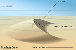
A dune is a large pile of wind-blown material, typically sand or snow. As the pile accumulates, its larger surface area increases the rate of deposition in a positive feedback loop until the dune collapses under its own weight. This process causes dunes to move in the direction of the wind over time. [6] [7]
Death Valley Mesquite Flats sand dunes. Death Valley Mesquite Flats Sand Dunes 2013.jpg
Death Valley Mesquite Flats sand dunes.
Barchan A type of dune that forms as a result of low sediment supply in regions where wind blows in one primary direction. This causes the dune to have a concave shape, with the tails facing downwind. [8] Transverse dunes and Seif dunes are some alternative examples of the effect of unidirectional air flow on dune formation.
Barchan dune schematic. Barchan.jpg
Barchan dune schematic.
Ripple marks Ripple marks are small ridges of sediment that form due to wind or water blowing over loose sediment in either a current or wave pattern. Aeolian ripples result from high velocity winds which form fine, well-sorted grain particles into long, flat, asymmetrical ripples.[ citation needed ]
Asymmetrical wind ripples on aragonite sand from San Salvador Island in the Bahamas. Backbeach asymmetrical wind ripples on aragonite sand (San Salvador Island, Bahamas) 4 (15808490067).jpg
Asymmetrical wind ripples on aragonite sand from San Salvador Island in the Bahamas.
Loess Silt sized particles that can be carried by the wind over extensive distances, usually homogenous and highly porous. Generally, loess contains angular grains that are not well-polished due to the nature of their transport.
Loess hills in western Iowa. Loess Hills 0633.jpg
Loess hills in western Iowa.
Desert pavement Angular rocks and sand grains that form a pavement due to inflation. Aeolian forces deposit sand grains between and beneath surrounding rocks which results in the rise of a stony layer of pavement. [9] Desert pavement can also form as a result of deflation, in which case finer rock particles are blown away and scattered by wind, leaving the pavement behind.
Desert pavement from the Mojave Desert. Desert Pavement Mojave 2000.jpg
Desert pavement from the Mojave Desert.
Desert varnish A coating that can be found on the surface of desert rocks that can only be explained by the presence of clay particles which have been transported by wind. The discoloration of the clays can most often be attributed to black manganese oxides and red iron oxides.
Desert varnish in Valley of Fire State Park. Desert varnish - Valley of Fire State Park.JPG
Desert varnish in Valley of Fire State Park.

Erosional

Erosional landforms grow when more sediment is removed from an area faster than it is deposited. They are widespread in hardened, wind-swept snow surfaces, such as the Antarctic Plateau: see sastrugi. In sand and rock, they are rarely preserved except in arid regions. [10] Outside of arid regions, moving water - which is heavier and more erosive than wind - erases aeolian landforms. [11] Large basins are complex and there is often one or more non-aeolian process at work, including tectonics, glacial and alluvial forces. There are several types of landforms associated with erosion.

Examples of Erosional Landforms
LandformDescriptionImage
Deflation basin A depression in the land that can be found in deserts due to the removal of particles by wind; it can also be referred to as a "blowout".
Blowout outside of Earth, Texas Blowout Earth TX.jpg
Blowout outside of Earth, Texas
Ventifacts Rock samples that demonstrate the erosion caused by aeolian processes over time. Erosional processes by wind can result in smoothing and polishing as well as the creation of grooves.
Hematite rich ventifact from Windy Gap, Wyoming with extensive polishing by wind. BIF ventifact,Windy Gap, Wyoming.jpg
Hematite rich ventifact from Windy Gap, Wyoming with extensive polishing by wind.
Mushroom rocks Formations that develop over thousands of years when the top of an outcrop is eroded by wind at a slower rate than the base of the outcrop.
Mushroom rocks from northern Arizona. Mushroom rocks03.jpg
Mushroom rocks from northern Arizona.
Lag deposit Angular rocks and sand grains that have been left behind during the gradual removal of finer particles by aeolian processes. Lag deposits can also form due to removal of finer particles by water.
Yardangs A protruding rock that results from a streamlined carving from consolidated material by wind abrasion by dust and sand, and deflation.
Yardangs in dunes at White Sands National Park in New Mexico. Yardangs in dunes, White Sands National Park, New Mexico, United States.jpg
Yardangs in dunes at White Sands National Park in New Mexico.

See also

Related Research Articles

<span class="mw-page-title-main">Dune</span> Hill of loose sand built by aeolian processes or the flow of water

A dune is a landform composed of wind- or water-driven sand. It typically takes the form of a mound, ridge, or hill. An area with dunes is called a dune system or a dune complex. A large dune complex is called a dune field, while broad, flat regions covered with wind-swept sand or dunes, with little or no vegetation, are called ergs or sand seas. Dunes occur in different shapes and sizes, but most kinds of dunes are longer on the stoss (upflow) side, where the sand is pushed up the dune, and have a shorter slip face in the lee side. The valley or trough between dunes is called a dune slack.

<span class="mw-page-title-main">Erosion</span> Natural processes that remove soil and rock

Erosion is the action of surface processes that removes soil, rock, or dissolved material from one location on the Earth's crust and then transports it to another location where it is deposited. Erosion is distinct from weathering which involves no movement. Removal of rock or soil as clastic sediment is referred to as physical or mechanical erosion; this contrasts with chemical erosion, where soil or rock material is removed from an area by dissolution. Eroded sediment or solutes may be transported just a few millimetres, or for thousands of kilometres.

<span class="mw-page-title-main">Sediment</span> Particulate solid matter that is deposited on the surface of land

Sediment is a naturally occurring material that is broken down by processes of weathering and erosion, and is subsequently transported by the action of wind, water, or ice or by the force of gravity acting on the particles. For example, sand and silt can be carried in suspension in river water and on reaching the sea bed deposited by sedimentation; if buried, they may eventually become sandstone and siltstone through lithification.

<span class="mw-page-title-main">Ventifact</span> Rock that has been eroded by wind-driven sand or ice crystals

A ventifact is a rock that has been abraded, pitted, etched, grooved, or polished by wind-driven sand or ice crystals. The word “Ventifact” is derived from the Latin word “Ventus” meaning ‘wind’. These geomorphic features are most typically found in arid environments where there is little vegetation to interfere with aeolian particle transport, where there are frequently strong winds, and where there is a steady but not overwhelming supply of sand.

<span class="mw-page-title-main">Sastrugi</span> Sharp irregular grooves or ridges formed on a snow surface

Sastrugi, or zastrugi, are features formed by erosion of snow by wind. They are found in polar regions, and in snowy, wind-swept areas of temperate regions, such as frozen lakes or mountain ridges. Sastrugi are distinguished by upwind-facing points, resembling anvils, which move downwind as the surface erodes. These points usually lie along ridges parallel to the prevailing wind; they are steep on the windward side and sloping to the leeward side. Smaller irregularities of this type are known as ripples or wind ridges.

Landforms are categorized by characteristic physical attributes such as their creating process, shape, elevation, slope, orientation, rock exposure, and soil type.

<span class="mw-page-title-main">Barchan</span> Crescent-shaped dune

A barchan or barkhan dune is a crescent-shaped dune. The term was introduced in 1881 by Russian naturalist Alexander von Middendorf, based on their occurrence in Turkestan and other inland desert regions. Barchans face the wind, appearing convex and are produced by wind action predominantly from one direction. They are a very common landform in sandy deserts all over the world and are arc-shaped, markedly asymmetrical in cross section, with a gentle slope facing toward the wind sand ridge, comprising well-sorted sand.

<span class="mw-page-title-main">Aeolian processes</span> Processes due to wind activity

Aeolian processes, also spelled eolian, pertain to wind activity in the study of geology and weather and specifically to the wind's ability to shape the surface of the Earth. Winds may erode, transport, and deposit materials and are effective agents in regions with sparse vegetation, a lack of soil moisture and a large supply of unconsolidated sediments. Although water is a much more powerful eroding force than wind, aeolian processes are important in arid environments such as deserts.

<span class="mw-page-title-main">Yardang</span> Streamlined aeolian landform

A yardang is a streamlined protuberance carved from bedrock or any consolidated or semiconsolidated material by the dual action of wind abrasion by dust and sand and deflation. Yardangs become elongated features typically three or more times longer than wide, and when viewed from above, resemble the hull of a boat. Facing the wind is a steep, blunt face that gradually gets lower and narrower toward the lee end. Yardangs are formed by wind erosion, typically of an originally flat surface formed from areas of harder and softer material. The soft material is eroded and removed by the wind, and the harder material remains. The resulting pattern of yardangs is therefore a combination of the original rock distribution, and the fluid mechanics of the air flow and resulting pattern of erosion.

<span class="mw-page-title-main">Blowout (geomorphology)</span> Depressions in a sand dune ecosystem caused by the removal of sediments by wind

Blowouts are sandy depressions in a sand dune ecosystem (psammosere) caused by the removal of sediments by wind.

<span class="mw-page-title-main">Dreikanter</span> Type of rock

A dreikanter is a type of ventifact that typically forms in desert or periglacial environments due to the abrasive action of blowing sand.

<span class="mw-page-title-main">Saltation (geology)</span> Particle transport by fluids

In geology, saltation is a specific type of particle transport by fluids such as wind or water. It occurs when loose materials are removed from a bed and carried by the fluid, before being transported back to the surface. Examples include pebble transport by rivers, sand drift over desert surfaces, soil blowing over fields, and snow drift over smooth surfaces such as those in the Arctic or Canadian Prairies.

<span class="mw-page-title-main">Erg (landform)</span> Broad area of desert covered with wind-swept sand

An erg is a broad, flat area of desert covered with wind-swept sand with little or no vegetative cover. The word is derived from the Arabic word ʿarq (عرق), meaning "dune field". Strictly speaking, an erg is defined as a desert area that contains more than 125 km2 (48 sq mi) of aeolian or wind-blown sand and where sand covers more than 20% of the surface. Smaller areas are known as "dune fields". The largest hot desert in the world, the Sahara, covers 9 million square kilometres and contains several ergs, such as the Chech Erg and the Issaouane Erg in Algeria. Approximately 85% of all the Earth's mobile sand is found in ergs that are greater than 32,000 km2 (12,355 sq mi), the largest being the Rub' al Khali, the Empty Quarter of the Arabian Peninsula. Ergs are also found on other celestial bodies, such as Venus, Mars, and Saturn's moon Titan.

The Bagnold formula, named after Ralph Alger Bagnold, relates the amount of sand moved by the wind to wind speed by saltation. It states that the mass transport of sand is proportional to the third power of the friction velocity. Under steady conditions, this implies that mass transport is proportional to the third power of the excess of the wind speed over the minimum wind speed that is able to activate and sustain a continuous flow of sand grains.

<span class="mw-page-title-main">Abrasion (geology)</span> Process of erosion

Abrasion is a process of erosion that occurs when material being transported wears away at a surface over time, commonly happens in ice and glaciers. The primary process of abrasion is physical weathering. Its the process of friction caused by scuffing, scratching, wearing down, marring, and rubbing away of materials. The intensity of abrasion depends on the hardness, concentration, velocity and mass of the moving particles. Abrasion generally occurs in four ways: glaciation slowly grinds rocks picked up by ice against rock surfaces; solid objects transported in river channels make abrasive surface contact with the bed and walls; objects transported in waves breaking on coastlines; and by wind transporting sand or small stones against surface rocks. Abrasion is the natural scratching of bedrock by a continuous movement of snow or glacier downhill. This is caused by a force, friction, vibration, or internal deformation of the ice, and by sliding over the rocks and sediments at the base that causes the glacier to move.

<span class="mw-page-title-main">Olympia Undae</span> Martian dune field

Olympia Undae is a vast dune field in the north polar region of the planet Mars. It consists of a broad "sand sea" or erg that partly rings the north polar plateau from about 120° to 240°E longitude and 78° to 83°N latitude. Stretching about 1,100 km (680 mi) across and covering an area of 470,000 km2, Olympia Undae is the largest continuous dune field on Mars. It is similar in size to the Rub' Al Khali in the Arabian Peninsula, the largest active erg on Earth.

The Bibliography of Aeolian Research (BAR) is a comprehensive 2015 bibliography focused on the study of the detachment, transport, and deposition of sediments by wind.

<span class="mw-page-title-main">Niveo-aeolian deposition</span> Deposition of sediments onto snow or ice

Niveo-aeolian or cryo-aeolian deposition is the process by which fine-grained sediments are transported by wind and deposited on or mixed with snow or ice. The wind sweeps the snow and sand grains into aeolian landforms such as ripples, and further sorts the snow and ice grains into distinct layers. When snow melts or sublimates, the sediments are redeposited onto the surface below., forming patterns known as denivation features.

<span class="mw-page-title-main">Tropical desert</span> Type of desert

Tropical deserts are located in regions between 15 and 30 degrees latitude. The environment is very extreme, and they have the highest average monthly temperature on Earth. Rainfall is sporadic; precipitation may not be observed at all in a few years. In addition to these extreme environmental and climate conditions, most tropical deserts are covered with sand and rocks, and thus too flat and lacking in vegetation to block out the wind. Wind may erode and transport sand, rocks and other materials; these are known as eolian processes. Landforms caused by wind erosion vary greatly in characteristics and size. Representative landforms include depressions and pans, Yardangs, inverted topography and ventifacts. No significant populations can survive in tropical deserts due to extreme aridity, heat and the paucity of vegetation; only specific flora and fauna with special behavioral and physical mechanisms are supported. Although tropical deserts are considered to be harsh and barren, they are in fact important sources of natural resources and play a significant role in economic development. Besides the equatorial deserts, there are many hot deserts situated in the tropical zone.

<span class="mw-page-title-main">Loess Plateau</span> Plateau in north/northwest China

The Chinese Loess Plateau, or simply the Loess Plateau, is a plateau in north-central China formed of loess, a clastic silt-like sediment formed by the accumulation of wind-blown dust. It is located southeast of the Gobi Desert and is surrounded by the Yellow River. It includes parts of the Chinese provinces of Qinghai, Gansu, Shaanxi and Shanxi. The depositional setting of the Chinese Loess Plateau was shaped by the tectonic movement in the Neogene period, after which strong southeast winds caused by the East Asian Monsoon transported sediment to the plateau during the Quaternary period. The three main morphological types in the Loess Plateau are loess platforms, ridges and hills, formed by the deposition and erosion of loess. Most of the loess comes from the Gobi Desert and other nearby deserts. The sediments were transported to the Loess Plateau during interglacial periods by southeasterly prevailing winds and winter monsoon winds. After the deposition of sediments on the plateau, they were gradually compacted to form loess under the arid climate.

References

  1. Bagnold, Ralph (1941). The Physics of Blown Sand and Desert Dunes .
  2. Archie, Deithra L. "Aeolian Processes and Landforms" (PDF). New Mexico State University. p. 2. Archived from the original (PDF) on 2010-11-22. Retrieved 2008-08-06.
  3. Telfer, M.; Parteli, E.; Radebaugh, J.; et al. (2018). "Dunes on Pluto". Science . 360 (6392): 992–997. Bibcode:2018Sci...360..992T. doi: 10.1126/science.aao2975 . PMID   29853681.
  4. 1 2 "Aeolian landform". The Canadian Encyclopedia. Archived from the original on 2007-08-17. Retrieved 2008-08-06.
  5. Balasubramanian, A. (February 2007). "AEOLIAN LANDFORMS". ResearchGate.
  6. "Geology of Great Sand Dunes National Park". www.usgs.gov. Retrieved 2020-11-23.
  7. "Snow Dunes | National Snow and Ice Data Center". nsidc.org. Retrieved 2020-11-23.
  8. "Barchan | sand dune". Encyclopedia Britannica. Retrieved 2020-11-23.
  9. Pelletier, Jon D.; Cline, Michael; DeLong, Stephen B. (November 2007). "Desert pavement dynamics: numerical modeling and field-based calibration". Earth Surface Processes and Landforms. 32 (13): 1913–1927. Bibcode:2007ESPL...32.1913P. doi: 10.1002/esp.1500 .
  10. Frank R. Spellman (16 March 2010). Geography for Nongeographers. Government Institutes. pp. 111–. ISBN   978-1-60590-687-4.
  11. Michael A. Summerfield (12 May 2014). Global Geomorphology. Routledge. pp. 239–. ISBN   978-1-317-88511-5.