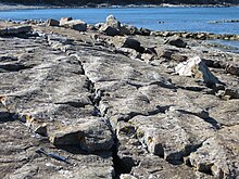
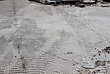
In geology, ripple marks are sedimentary structures (i.e., bedforms of the lower flow regime) and indicate agitation by water (current or waves) or directly by wind.
In geology, ripple marks are sedimentary structures (i.e., bedforms of the lower flow regime) and indicate agitation by water (current or waves) or directly by wind.
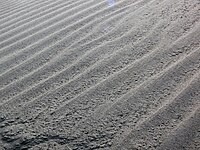
| Straight | Straight ripples generate cross-laminae that all dip in the same direction, and lie in the same plane. These forms of ripples are constructed by unidirectional flow of the current. |
|---|---|
| Sinuous | Sinuous ripples generate cross-laminae that are curvy. They show a pattern of curving up and down as shown in picture. Sinuous ripples produce trough cross lamination. All laminae formed under this type of ripple dip at an angle to the flow as well as downstream. These laminae are also formed by the unidirectional current. |
| Catenary | Catenary ripples generate cross-laminae that are curvy but have a unidirectional swoop. They show a pattern similar to what a repeated "W" would look like. Like the sinuous ripples, this form of ripple is created by unidirectional flow with the dip at an angle to the flow as well as downstream. |
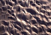
| Linguoid / Lunate | Linguoid ripples have lee slope surfaces that are curved generating a laminae similar to caternary and sinuous ripples. Linguoid ripples generate an angle to the flow as well as downstream. Linguoid ripples have a random shape rather than a "W" shape, as described in the catenary description. Lunate ripples, meaning crescent shaped ripples, are exactly like linguoid ripples except that the stoss sides are curved rather than the lee slope. All other features are the same. |
| Size | Description |
|---|---|
| Very small | Very small cross-lamination means that the ripple height is roughly one centimeter. It is lenticular, wavy and flaser lamination. |
| Small | Small cross-bedding are ripples set at a height less than ten centimeters, while the thickness is only a few millimeters. Some ripples that may fit this category are wind ripples, wave ripples, and current ripples. |
| Medium | Medium cross-lamination are ripples with a height greater than ten centimeters, and less than one meter in thickness. Some ripples that may fit this category would be current-formed sand waves, and storm-generated hummocky cross stratification. |
| Large | Large cross-bedding are ripples with a height greater than one meter, and a thickness equivalent to one meter or greater. Some ripples that may fit this category would be high energy river-bed bars, sand waves, epsilon cross-bedding and Gilbert-type cross-bedding. |


A dune is a landform composed of wind- or water-driven sand. It typically takes the form of a mound, ridge, or hill. An area with dunes is called a dune system or a dune complex. A large dune complex is called a dune field, while broad, flat regions covered with wind-swept sand or dunes, with little or no vegetation, are called ergs or sand seas. Dunes occur in different shapes and sizes, but most kinds of dunes are longer on the stoss (upflow) side, where the sand is pushed up the dune, and have a shorter slip face in the lee side. The valley or trough between dunes is called a dune slack.

Sedimentary rocks are types of rock that are formed by the accumulation or deposition of mineral or organic particles at Earth's surface, followed by cementation. Sedimentation is the collective name for processes that cause these particles to settle in place. The particles that form a sedimentary rock are called sediment, and may be composed of geological detritus (minerals) or biological detritus. The geological detritus originated from weathering and erosion of existing rocks, or from the solidification of molten lava blobs erupted by volcanoes. The geological detritus is transported to the place of deposition by water, wind, ice or mass movement, which are called agents of denudation. Biological detritus was formed by bodies and parts of dead aquatic organisms, as well as their fecal mass, suspended in water and slowly piling up on the floor of water bodies. Sedimentation may also occur as dissolved minerals precipitate from water solution.

Aeolian processes, also spelled eolian, pertain to wind activity in the study of geology and weather and specifically to the wind's ability to shape the surface of the Earth. Winds may erode, transport, and deposit materials and are effective agents in regions with sparse vegetation, a lack of soil moisture and a large supply of unconsolidated sediments. Although water is a much more powerful eroding force than wind, aeolian processes are important in arid environments such as deserts.
A way up structure, way up criterion, or geopetal indicator is a characteristic relationship observed in a sedimentary or volcanic rock, or sequence of rocks, that makes it possible to determine whether they are the right way up or have been overturned by subsequent deformation. This technique is particularly important in areas affected by thrusting and where there is a lack of other indications of the relative ages of beds within the sequence, such as in the Precambrian where fossils are rare.

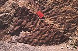
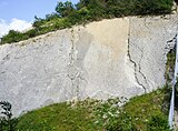
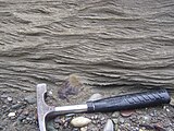
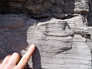
In geology, cross-bedding, also known as cross-stratification, is layering within a stratum and at an angle to the main bedding plane. The sedimentary structures which result are roughly horizontal units composed of inclined layers. The original depositional layering is tilted, such tilting not being the result of post-depositional deformation. Cross-beds or "sets" are the groups of inclined layers, which are known as cross-strata.

Sediment transport is the movement of solid particles (sediment), typically due to a combination of gravity acting on the sediment, and the movement of the fluid in which the sediment is entrained. Sediment transport occurs in natural systems where the particles are clastic rocks, mud, or clay; the fluid is air, water, or ice; and the force of gravity acts to move the particles along the sloping surface on which they are resting. Sediment transport due to fluid motion occurs in rivers, oceans, lakes, seas, and other bodies of water due to currents and tides. Transport is also caused by glaciers as they flow, and on terrestrial surfaces under the influence of wind. Sediment transport due only to gravity can occur on sloping surfaces in general, including hillslopes, scarps, cliffs, and the continental shelf—continental slope boundary.

In geology, depositional environment or sedimentary environment describes the combination of physical, chemical, and biological processes associated with the deposition of a particular type of sediment and, therefore, the rock types that will be formed after lithification, if the sediment is preserved in the rock record. In most cases, the environments associated with particular rock types or associations of rock types can be matched to existing analogues. However, the further back in geological time sediments were deposited, the more likely that direct modern analogues are not available.
The Tumblagooda Sandstone is a geological formation deposited during the Silurian or Ordovician periods, between four and five hundred million years ago, and is now exposed on the west coast of Australia in river and coastal gorges near the tourist town of Kalbarri, Kalbarri National Park and the Murchison River gorge, straddling the boundary of the Carnarvon and Perth basins. Visible trackways are interpreted by some to be the earliest evidence of fully terrestrial animals.

Sedimentary structures include all kinds of features in sediments and sedimentary rocks, formed at the time of deposition.

An antidune is a bedform found in fluvial and other channeled environments. Antidunes occur in supercritical flow, meaning that the Froude number is greater than 1.0 or the flow velocity exceeds the wave velocity; this is also known as upper flow regime. In antidunes, sediment is deposited on the upstream (stoss) side and eroded from the downstream (lee) side, opposite lower flow regime bedforms. As a result, antidunes migrate in an upstream direction, counter to the current flow. Antidunes are called in-phase bedforms, meaning that the water surface elevation mimics the bed elevation; this is due to the supercritical flow regime. Antidune bedforms evolve rapidly, growing in amplitude as they migrate upstream. The resultant wave at the water's surface also increases in amplitude. When that wave becomes unstable, breaks and washes downstream, much of the antidune bedform may be destroyed.
Hummocky cross-stratification is a type of sedimentary structure found in sandstones. It is a form of cross-bedding usually formed by the action of large storms, such as hurricanes. It takes the form of a series of "smile"-like shapes, crosscutting each other. It is only formed at a depth of water below fair-weather wave base and above storm-weather wave base. They are not related to "hummocks" except in shape.

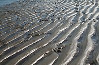
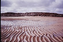
In sedimentology, wave-formed ripples or wave-formed ripple marks are a feature of sediments and dunes. These ripple marks are often characterised by symmetric cross sections and long relatively straight crests, which may commonly bifurcate. Commonly, these crests can be truncated by subsequent flows. Their wavelength (periodicity) depends on the sediment grain size, water depth and water-particle orbits in the waves. On tidal flats the pattern of wave-formed ripples may be complicated, as a product of changing depth and wind and tidal runoff directions. Symmetrical ripples are commonly found in shallow waters. Beaches are a good place to find these ripples.

A bedform is a geological feature that develops at the interface of fluid and a moveable bed, the result of bed material being moved by fluid flow. Examples include ripples and dunes on the bed of a river. Bedforms are often preserved in the rock record as a result of being present in a depositional setting. Bedforms are often characteristic to the flow parameters, and may be used to infer flow depth and velocity, and therefore the Froude number.
A contourite is a sedimentary deposit commonly formed on continental rise to lower slope settings, although they may occur anywhere that is below storm wave base. Countourites are produced by thermohaline-induced deepwater bottom currents and may be influenced by wind or tidal forces. The geomorphology of contourite deposits is mainly influenced by the deepwater bottom-current velocity, sediment supply, and seafloor topography.
A paleocurrent or paleocurrent indicator is a geological feature that helps one determine the direction of flowing water in the geologic past. This is an invaluable tool in the reconstruction of ancient depositional environments.

Parting lineation is a subtle sedimentary structure in which sand grains are aligned in parallel lines or grooves on the surface of a body of sand. The orientation of the lineation is used as a paleocurrent indicator, although the precise flow direction is often indeterminable. They are also the primary indicator of the lower part of the upper flow regime bedform.
Vegetation-induced sedimentary structures (VISS) are primary sedimentary structures formed by the interaction of detrital sediment with in situ plants. VISS provide physical evidence of vegetation's fundamental role in mediating sediment accumulation and erosion in clastic depositional environments. VISS can be broken into seven types, five being hydrodynamic and two being decay-related. The simple hydrodynamic VISS are categorized by centroclinal cross strata, scratch semicircles and upturned beds. The complex hydrodynamic VISS are categorized by coalesced scour fills and scour-and-mound beds. The decay-related VISS are categorized by mudstone-filled hollows and downturned beds.
Transverse aeolian ridges (TARs) are visually bright features commonly found in topographic depressions on Mars. These small-scale and relict bedforms were first seen in narrow-angle images from the Mars Orbiter Camera (MOC) and were called “ridges” to preserve both dunes and ripples as formative mechanisms. While TARs are widespread on Mars, their formation, age, composition, and role in past Martian sediment cycles remain poorly constrained.

Niveo-aeolian or cryo-aeolian deposition is the process by which fine-grained sediments are transported by wind and deposited on or mixed with snow or ice. The wind sweeps the snow and sand grains into aeolian landforms such as ripples, and further sorts the snow and ice grains into distinct layers. When snow melts or sublimates, the sediments are redeposited onto the surface below., forming patterns known as denivation features.
Cyclic steps are rhythmic bedforms associated with Froude super-critical flow instability. They are a type of sediment wave, and are created when supercritical sediment-laden water travels downslope through sediment beds. Each ‘step’ has a steep drop, and together they tend to migrate upstream. On the ocean floor, this phenomenon was first shown to be possible in 2006, although it was observed in open-channel flows over a decade earlier. Geological features appearing to be submarine cyclic steps have been detected in the northern lowlands of Mars in the Aeolis Mensae region, providing evidence of an ancient Martian ocean.
| Authority control databases: National |
|---|