Aerial photograph interpretation (geology)

Last updated

Oblique aerial photograph covering the Cappadocia, nearby Goreme, Turkey. Cappadocia Aerial View Landscape.jpg
Oblique aerial photograph covering the Cappadocia, nearby Gorëme, Turkey.

Aerial photograph interpretation is a method of extrapolating geological details of the ground surface from aerial images. [1] It allows geologists to analyze the distinguishing geological features and structures, plant cover, past history of the site, soil properties, and topography of the study area. [1] [2] It is crucial in the early stage of a geological mapping as it is less time-consuming and offers important data at a minimal price. [1] It is also commonly used in other industries such as forest management, environmental science, disciplines of engineering, and investigating aviation accidents. [1] [3] [4]

Contents

Aerial photograph interpretation is also useful to assess the risk of landslides and other dangers in the natural environment in the geotechnical industry. [5] As proper interpretation of aerial photos can reveal historical changes of the topography and the details of previous landslides, it can be help determine whether an area is stable or not. [5] [4] Geologists can further utilize the interpretations to design the most favorable locations for field studies and the acquisition of data. [5]

Geologic applications of aerial photographs

Landslide hazard assessment

Aerial photographs play an important role in assessing the risk of different natural hazards, particularly landslides. [1] They can be used to determine whether hillslopes are stable or not. [1] They can also record the history of landslides experienced in that area. [1] For example, in an area with more than half of the ground surface constitutes natural terrain, which is the unmodified natural environment, there are more slopes. [1] The majority of naturally occurring landslides happen in isolated locations, posing a threat to ongoing development. [1] Aerial photographs can be used to find all current and historical landslides in and around the research region to gauge vulnerability to future landslides. [1]

A landslide scar refers to the local area disrupted by the landslide. [5] It comprises the starting point, also called the "source", the detached substances and a trail that describes the movement of a landslide. [5] Every landslide scar is noted, along with its position, size, and the estimated date of the event. For the current landslides, in the photograph, they can be recognized easily by the unique light-colored landslide scar. [1] Very few plants can be observed on the scar. [1] For historical or old landslides, they may be hidden by vegetation such as bushes and woody plants, but scars in the land are still present. [1] This type of landslide is recognized by a concave depression that appears on a major steep slope. [1] Depression is when a feature is lowered compared to its surroundings. It is important to take into account the age of historical landslides and assess their applicability to the present climate and environment. [5]

Sketch diagram showing the aerial photograph of Pat Heung in 1989 in Hong Kong. It shows how the yellow current landslides were identified within the red study area on the slopes of the natural terrain using interpretation techniques. A total of seven current landslides were identified. The numbers and years of occurrence are marked with the respective current landslides. (not in scale) Landslides from hk.png
Sketch diagram showing the aerial photograph of Pat Heung in 1989 in Hong Kong. It shows how the yellow current landslides were identified within the red study area on the slopes of the natural terrain using interpretation techniques. A total of seven current landslides were identified. The numbers and years of occurrence are marked with the respective current landslides. (not in scale)

Determining geological structures and types of rock

Aerial photographs can be used to identify different rock types on the rock exposure and the arrangement of the geological structures. [1] [5] These structures are produced by deformation processes during tectonic movement, such as faults and folds. Geologists identify different geological features and structures based on photo-lineaments. [4] [1] Photo-lineaments are lines that appear on the photos and are thought to be driven by geological factors. [1] Those identified photo-lineaments are aligned with the linear topographic landforms. [1] They can be referred to as joints, faults, dikes, or rock contacts. [1] Some faults may even occur along rivers and mountain valleys. [1]

For example, in Hong Kong the two major rocks are granite (35%) and volcanic rock (50%). [1] Since granite is more easily weathered and eroded than volcanic rocks, it usually forms gullies, which are the valleys on a smaller scale, whereas volcanic rocks form the summit, which is the location with a higher elevation in the mountains. [5] [1]

Example of the application of identifying geological structures and rock contacts using aerial photographs. The black dash lines refer to some local faults which are determined according to the photo-lineaments. The yellow area is the deposits. The pale blue area is volcanic rock. The blue area (bottom right) is rhyolite. The pink area is granite. The red line is the research area that is located on a hillslope in North Lantau, Hong Kong. (not in scale) Example of determing geological structures.png
Example of the application of identifying geological structures and rock contacts using aerial photographs. The black dash lines refer to some local faults which are determined according to the photo-lineaments. The yellow area is the deposits. The pale blue area is volcanic rock. The blue area (bottom right) is rhyolite. The pink area is granite. The red line is the research area that is located on a hillslope in North Lantau, Hong Kong. (not in scale)

Another example of determining geological structures is a fold found in Wyoming in the United States. [6] A fold is developed when the rock layers are squeezed and curved by forces and do not break during the deformation. [7] It is an anticline which has the earliest-formed rock layers in the inner part and the youngest rock layer on the outer part of the fold. [8] [9] The hinge line of this fold, which refers to a line tracing the maximum bend of the fold structure, is not a straight line. [9] [6] The head and the tail of the hinge line dip downward from the original horizontal plane. It is an asymmetrical fold which means the axial plane is not in the upright orientation but inclined. [7] The axial plane is a hypothetical plane dividing two sides of the fold. [7] The limbs dip in opposite directions and are formed by tilted sedimentary rock layers. [6] Limbs belong to the straight sections on the two sides of a fold. Aerial photographs are helpful for geologists to observe large-scale geological structures without spending large amounts of time in fields.

A diagram describing the structure of a fold. Fold terminology-01.jpg
A diagram describing the structure of a fold.

Boulder survey

Boulder surveys determine and categorize the areas of boulders using aerial photograph interpretation. [1] After the survey the properties (dimension, amount, form) of boulders are combined with the geological map. This helps detect dangers from the falling of these large rock pieces, especially when conducting new projects close to the hillsides. [1]

Dense forests may obstruct the view of boulders from aerial photographs, which is one of the limitations of using aerial photographs to conduct a boulder survey. [1] Therefore, old aerial photographs with less vegetation are usually more beneficial for boulder mapping. Hillslopes are often occupied by some small village houses which produce a shadow. [1] These factors may decrease the efficiency of the boulder survey whereas bare ground allows for typically good sight of the terrain. [1]

Sketch map of the results of a boulder survey in Northern Lantau Island in Hong Kong. Different colors of areas show varying densities of boulders. Unscaled vegetation density map of Northern Lantau.jpg
Sketch map of the results of a boulder survey in Northern Lantau Island in Hong Kong. Different colors of areas show varying densities of boulders.

Geologists mark down the locations of the boulders on maps after making observations from aerial photographs to develop a sense of the possible boulder locations before going to the site. For example, from figure 17, it is observed that several boulders were settled on the hillslopes along the nearby footpaths. From the vertical view of the aerial photograph, the positions and relative dimensions of the boulders can be determined and measured easily. For an initial assessment of boulders on a wide and isolated landscape, conducting a boulder survey is necessary. [1]

Studying landforms

Aerial photographs can be used to help study, recognize, and classify landforms, which refers to the topographical characteristics created by the environmental systems. [1] They usually contain some distinct components and sets of features. [1] Certain fundamental spatial distributions of features are used to distinguish different landforms. [1] Differences in terrain surface elevation, river flow, colors of the aerial photographs, spatial distribution of tones, and the occurrence of plant covers are considered during landform studies. [1] Watersheds, which refer to the regions that separate drainage basins, are able to be defined using small-scale aerial photographs. [5] Landform studies also help identify decreases in surface elevation in natural terrain. and river courses [5]

Sketch map showing an example of landform studies in Luk Keng Hill. Different colors of areas show varying landform features (not in scale). Landform studies 2.png
Sketch map showing an example of landform studies in Luk Keng Hill. Different colors of areas show varying landform features (not in scale).

Regolith mapping

Regolith mapping helps distinguish different kinds of superficial deposits which refer to loosely arranged aggregates of weathered materials on the land surface. [1] [10] Aerial photographs can be used to establish the borders between the fluvial and gravity-driven hillslope sediments. [1] These superficial deposits usually have indistinct borders. [1] Some examples of the deposits identified using regolith mapping are described below.

Valley colluvium

Valley colluvium refers to the loose, unconsolidated sediments that have been settled inside the water courses and are driven by river mechanisms. [1] They are thin in shape and extended into straight lines that follow the river channels. [1] The plants grown on the valley colluvium are thicker than the nearby areas. [1] Woody plants and large bushes dominate the vegetation. [1]

Debris fan colluvium

Debris fan colluvium refers to the aggregates of gravity-driven and fluvial deposits located near the hillslope's base or the eroded catchment area. [1] It appears shell-like from the vertical view and is cut by the flowing rivers. [1] In certain parts of the debris fan, there may be some woody plants covering the land surface. [1]

Example of a small-scale colluvium debris fan in Italy. Debris fan Furlo.JPG
Example of a small-scale colluvium debris fan in Italy.

Agricultural terraces

Regolith mapping can also be used to determine disrupted natural landscapes in aerial photographs. [1] For example, agricultural terraces, which refers to the level land surfaces divided by short back slopes and concrete barriers, is one of the disrupted landscapes. [1] Back slopes refer to the slopes constructed by removing soil or rocks from hillslopes for nearby infrastructure. They were developed for the purpose of growing rice. [1] The terraces are usually found on gentle slopes and bottom areas of the mountains. [1] They are usually covered with thick vegetation when the terraces are abandoned, or the farming activities are no longer active. [1]

Example of agricultural terraces in Italy. Collina di Montevecchia fianco .jpg
Example of agricultural terraces in Italy.

Related Research Articles

<span class="mw-page-title-main">Tor (rock formation)</span> Large, free-standing rock outcrop on a gentle hill summit

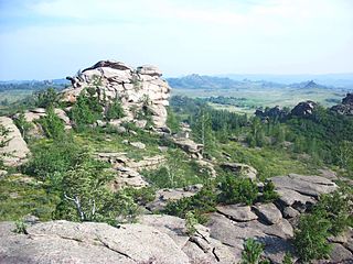
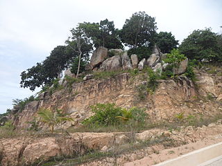
A tor, which is also known by geomorphologists as either a castle koppie or kopje, is a large, free-standing rock outcrop that rises abruptly from the surrounding smooth and gentle slopes of a rounded hill summit or ridge crest. In the South West of England, the term is commonly also used for the hills themselves – particularly the high points of Dartmoor in Devon and Bodmin Moor in Cornwall.

<span class="mw-page-title-main">Landslide</span> Natural hazard involving ground movement

Landslides, also known as landslips, are several forms of mass wasting that may include a wide range of ground movements, such as rockfalls, mudflows, shallow or deep-seated slope failures and debris flows. Landslides occur in a variety of environments, characterized by either steep or gentle slope gradients, from mountain ranges to coastal cliffs or even underwater, in which case they are called submarine landslides.

<span class="mw-page-title-main">Geomorphology</span> Scientific study of landforms

Geomorphology is the scientific study of the origin and evolution of topographic and bathymetric features generated by physical, chemical or biological processes operating at or near Earth's surface. Geomorphologists seek to understand why landscapes look the way they do, to understand landform and terrain history and dynamics and to predict changes through a combination of field observations, physical experiments and numerical modeling. Geomorphologists work within disciplines such as physical geography, geology, geodesy, engineering geology, archaeology, climatology, and geotechnical engineering. This broad base of interests contributes to many research styles and interests within the field.

<span class="mw-page-title-main">Inselberg</span> Isolated, steep rock hill on relatively flat terrain

An inselberg or monadnock is an isolated rock hill, knob, ridge, or small mountain that rises abruptly from a gently sloping or virtually level surrounding plain. In Southern Africa a similar formation of granite is known as a koppie, an Afrikaans word from the Dutch diminutive word kopje. If the inselberg is dome-shaped and formed from granite or gneiss, it can also be called a bornhardt, though not all bornhardts are inselbergs. An inselberg results when a body of rock resistant to erosion, such as granite, occurring within a body of softer rocks, is exposed by differential erosion and lowering of the surrounding landscape.

<span class="mw-page-title-main">Regolith</span> A layer of loose, heterogeneous superficial deposits covering solid rock

Regolith is a blanket of unconsolidated, loose, heterogeneous superficial deposits covering solid rock. It includes dust, broken rocks, and other related materials and is present on Earth, the Moon, Mars, some asteroids, and other terrestrial planets and moons.

<span class="mw-page-title-main">Slump (geology)</span> Short distance movement of coherent earth down a slope

A slump is a form of mass wasting that occurs when a coherent mass of loosely consolidated materials or a rock layer moves a short distance down a slope. Movement is characterized by sliding along a concave-upward or planar surface. Causes of slumping include earthquake shocks, thorough wetting, freezing and thawing, undercutting, and loading of a slope.

<span class="mw-page-title-main">Terrain</span> Vertical and horizontal dimension and shape of land surface

Terrain or relief involves the vertical and horizontal dimensions of land surface. The term bathymetry is used to describe underwater relief, while hypsometry studies terrain relative to sea level. The Latin word terra means "earth."

<span class="mw-page-title-main">Engineering geology</span> Application of geology to engineering practice

Engineering geology is the application of geology to engineering study for the purpose of assuring that the geological factors regarding the location, design, construction, operation and maintenance of engineering works are recognized and accounted for. Engineering geologists provide geological and geotechnical recommendations, analysis, and design associated with human development and various types of structures. The realm of the engineering geologist is essentially in the area of earth-structure interactions, or investigation of how the earth or earth processes impact human made structures and human activities.

<span class="mw-page-title-main">Channel (geography)</span> Type of landform in which part of a body of water is confined to a relatively narrow but long region

In physical geography and hydrology, a channel is a landform on which a relatively narrow body of water is situated, such as a river, river delta or strait. While channel typically refers to a natural formation, the cognate term canal denotes a similar artificial structure.

<span class="mw-page-title-main">Mass wasting</span> Movement of rock or soil down slopes

Mass wasting, also known as mass movement, is a general term for the movement of rock or soil down slopes under the force of gravity. It differs from other processes of erosion in that the debris transported by mass wasting is not entrained in a moving medium, such as water, wind, or ice. Types of mass wasting include creep, solifluction, rockfalls, debris flows, and landslides, each with its own characteristic features, and taking place over timescales from seconds to hundreds of years. Mass wasting occurs on both terrestrial and submarine slopes, and has been observed on Earth, Mars, Venus, Jupiter's moon Io, and on many other bodies in the Solar System.

<span class="mw-page-title-main">Colluvium</span> Loose, unconsolidated sediments deposited at the base of a hillslope

Colluvium is a general name for loose, unconsolidated sediments that have been deposited at the base of hillslopes by either rainwash, sheetwash, slow continuous downslope creep, or a variable combination of these processes. Colluvium is typically composed of a heterogeneous range of rock types and sediments ranging from silt to rock fragments of various sizes. This term is also used to specifically refer to sediment deposited at the base of a hillslope by unconcentrated surface runoff or sheet erosion.

<span class="mw-page-title-main">Mudflow</span> Form of mass wasting

A mudflow, also known as mudslide or mud flow, is a form of mass wasting involving fast-moving flow of debris and dirt that has become liquified by the addition of water. Such flows can move at speeds ranging from 3 meters/minute to 5 meters/second. Mudflows contain a significant proportion of clay, which makes them more fluid than debris flows, allowing them to travel farther and across lower slope angles. Both types of flow are generally mixtures of particles with a wide range of sizes, which typically become sorted by size upon deposition.

There have been known various classifications of landslides. Broad definitions include forms of mass movement that narrower definitions exclude. For example, the McGraw-Hill Encyclopedia of Science and Technology distinguishes the following types of landslides:

<span class="mw-page-title-main">Geology of Hong Kong</span>

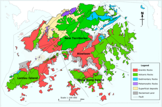
The geology of Hong Kong is dominated by igneous rocks formed during a major volcanic eruption period in the Mesozoic era. It made up 85% of Hong Kong's land surface and the remaining 15% are mostly sedimentary rocks located in the northeast New Territories. There are also a very small percentage of metamorphic rocks in the New Territories, formed by deformation of pre-existing sedimentary rocks (metamorphism).

<span class="mw-page-title-main">Aerial photographic and satellite image interpretation</span>

Aerial photographic and satellite image interpretation, or just image interpretation when in context, is the act of examining photographic images, particularly airborne and spaceborne, to identify objects and judging their significance. This is commonly used in military aerial reconnaissance, using photographs taken from reconnaissance aircraft and reconnaissance satellites.

<span class="mw-page-title-main">Flatiron (geomorphology)</span> Steeply sloping triangular landform

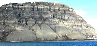
Traditionally in geomorphology, a flatiron is a steeply sloping triangular landform created by the differential erosion of a steeply dipping, erosion-resistant layer of rock overlying softer strata. Flatirons have wide bases that form the base of a steep, triangular facet that narrows upward into a point at its summit. The dissection of a hogback by regularly spaced streams often results in the formation of a series of flatirons along the strike of the rock layer that formed the hogback. As noted in some, but not all definitions, a number of flatirons are perched upon the slope of a larger mountain with the rock layer forming the flatiron inclined in the same direction as, but often at a steeper angle than the associated mountain slope. The name flatiron refers to their resemblance to an upended, household flatiron.

Discrete debris accumulation (DDA) is a non-genetic term in mountain glacial geology to aid identification of non-lithified sediments on a valley or mountain slope or floor. It is intended that the debris accumulation is discrete such that it can be mapped, in the field and/or from aerial or satellite imagery. The origin or formative process may well not be known clearly or be changed by subsequent investigators it is advisable to have a non-genetic field reference so that discussion can then be used to ascertain, if possible, the origin. Mountain areas may currently have glaciers (glacierized) or have had glaciers (glaciated) or be subject to forms of periglacial activity. A moraine would be an easily identified DDA as would an esker. Although scree (talus) is generally easily identified and mapped, these deposits may be modified by ice, avalanches or downslope movement to create essentially new landforms. Many small slope failures and landslides can give the appearance of moraines or protalus ramparts on slopes. After mapping as a DDA, further investigation might draw light on the origin of the feature.

Hillslope evolution is the changes in the erosion rates, erosion styles and form of slopes of hills and mountains over time.

<span class="mw-page-title-main">Remote sensing in geology</span> Data acquisition method for earth sciences

Remote sensing is used in the geological sciences as a data acquisition method complementary to field observation, because it allows mapping of geological characteristics of regions without physical contact with the areas being explored. About one-fourth of the Earth's total surface area is exposed land where information is ready to be extracted from detailed earth observation via remote sensing. Remote sensing is conducted via detection of electromagnetic radiation by sensors. The radiation can be naturally sourced, or produced by machines and reflected off of the Earth surface. The electromagnetic radiation acts as an information carrier for two main variables. First, the intensities of reflectance at different wavelengths are detected, and plotted on a spectral reflectance curve. This spectral fingerprint is governed by the physio-chemical properties of the surface of the target object and therefore helps mineral identification and hence geological mapping, for example by hyperspectral imaging. Second, the two-way travel time of radiation from and back to the sensor can calculate the distance in active remote sensing systems, for example, Interferometric synthetic-aperture radar. This helps geomorphological studies of ground motion, and thus can illuminate deformations associated with landslides, earthquakes, etc.

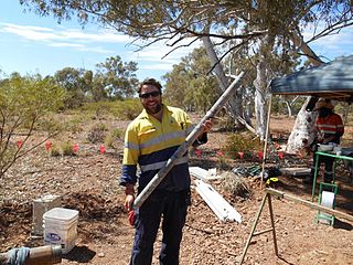
Geological structure measurement by LiDAR technology is a remote sensing method applied in structural geology. It enables monitoring and characterisation of rock bodies. This method's typical use is to acquire high resolution structural and deformational data for identifying geological hazards risk, such as assessing rockfall risks or studying pre-earthquake deformation signs.

References

  1. 1 2 3 4 5 6 7 8 9 10 11 12 13 14 15 16 17 18 19 20 21 22 23 24 25 26 27 28 29 30 31 32 33 34 35 36 37 38 39 40 41 42 43 44 45 46 47 48 49 50 51 Ho, H (2004). "Application of aerial photograph interpretation in geotechnical practice in Hong Kong (MSc thesis)". University of Hong Kong, Pokfulam, Hong Kong SAR. doi:10.5353/th_b4257758 (inactive 12 April 2024).{{cite journal}}: CS1 maint: DOI inactive as of April 2024 (link)
  2. National Council of Educational Research and Training. (2006). Introduction To Aerial Photographs. In Practical Work In Geography (pp. 69–83). Publication Division by the Secretary. https://www.philoid.com/epub/ncert/11/214/
  3. Legislative Council of Hong Kong. (2011). Legislative Council Panel on Development, Procurement of One Set of Large Format Digital Aerial Camera System (CB(1)1648/10-11(01)). https://www.legco.gov.hk/yr10-11/english/panels/dev/papers/devcb1-1648-1-e.pdf
  4. 1 2 3 Geotechnical Engineering Office, Civil Engineering and Development Department. (1987). Guide to Site Investigation (Geoguide 2) (pp. 1–352) https://www.cedd.gov.hk/filemanager/eng/content_108/eg2_20171218.pdf
  5. 1 2 3 4 5 6 7 8 9 10 Ho, H., & Roberts, K. (2016). Guidelines for Natural Terrain Hazard Studies, Second Edition. Geotechnical Engineering Office, Civil Engineering and Development Department. https://www.cedd.gov.hk/filemanager/eng/content_293/er138links.pdf
  6. 1 2 3 Lisle, R. J. (2003). Dupin's indicatrix: a tool for quantifying periclinal folds on maps. Geological magazine, 140(6), 721–726.
  7. 1 2 3 Geological Folds . (26 December 2015). Geology Page. https://www.geologypage.com/2015/12/geological-folds.html
  8. De Paor, D. G., Dordevic, M. M., Karabinos, P., Tewksbury, B. J., & Whitmeyer, S. J. (2016). The fold analysis challenge: A virtual globe-based educational resource. Journal of Structural Geology, 85, 85–94.
  9. 1 2 The National Park Service. (7 December 2021). Glossary of Geologic Terms. NPS.gov (U.S. National Park Service). Retrieved 5 November 2022, from https://www.nps.gov/subjects/geology/gri-glossary-of-geologic-terms.htm
  10. Hong Kong Geological Survey, Civil Engineering and Development Department. (2009). Weathering & Erosion – Introduction to Geomorphological Processes. https://hkss.cedd.gov.hk/hkss/eng/education/gs/eng/hkg/chapter4.htm?tab=2.