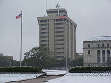
The Aggie Doppler Radar (ADRAD) is a Doppler weather radar located on the roof of the Eller Oceanography & Meteorology Building on the Texas A&M University campus in College Station, Texas.
The Aggie Doppler Radar (ADRAD) is a Doppler weather radar located on the roof of the Eller Oceanography & Meteorology Building on the Texas A&M University campus in College Station, Texas.
The Meteorology department first began its study of convective storms with the use of a 3 cm wavelength radar in the early 1950s. In 1962, they upgraded to a 10 cm, and in 1966, dual wavelength capability was added. After several modifications, the radar was placed on top of the newly completed Eller O&M Building in 1973. In 1992, the Aggie Doppler RADar was born with the installation of doppler capability. A final upgrade to the pedestal, removal of the side dishes, new processor, and work station occurred in 1997. [1]
In the early 1950s, the department received a 3-cm weather radar, AN/CPS-9, from the US Air Force. Using this 3-cm radar, researchers studied mid-latitude mesoscale systems, severe storms, and land-falling cyclones. [2] The AN/CPS-9 model was the first purpose-built weather radar. [3]
"The modified APS-2F at Texas A&M University, although not formally a part of the Texas Tornado Warning Network, was used at least once for warning purposes (Bigler 1956). On 5 April 1956, a tornado that produced damage in Bryan and College Station, Texas, was detected by the Texas A&M University radar. At noon that day, the Weather Bureau Forecast Center at Kansas City, Missouri, had issued what we would today call a tornado watch for an area just to the north of Bryan. The Texas A&M University radar observed strong, tall, hook-shaped echoes with V-notch signatures after 1400 LT. At 1445 LT, Texas A&M University meteorologists called the Bryan Police Department and forecast that a tornado would touch down 30 min. later. Actual damage started at 1509 LT. Texas A&M University also warned the College Station Consolidated School System, which decided to keep the children in their school buildings instead of releasing them at the scheduled time of 1500 LT. This is probably the first warning based solely on interpretation of radar data and is a good example of effective interaction between warning meteorologists and the local community. Today, with improved warning dissemination methods, increased community preparedness, and better radar capabilities and coverage, it would be less likely that a research team would be issuing warnings to communities directly." [4]
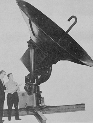
In 1962, a longer wavelength radar, 10-cm, was constructed and designated WSR/TAMU-1. The TAMU-1 was updated in 1966 to allow dual wavelength operations. After several modifications, the radar was placed on top of the newly completed Eller O&M Building in 1973. More modifications were made in 1989 in anticipation of adding Doppler capability.
One of the storms that was tracked with this radar was Hurricane Alicia in 1983. [5] As the storm made landfall, the Galveston NWS office lost its radar. [6] The A&M radar tracked the remnants as they moved inland.
The integration of a Lassen Research PSP-32 processor in 1992 enabled Doppler capability. The new system was renamed the TAMU Aggie Doppler Radar (TAMU-ADRAD). This system was updated in 1993. A final upgrade to the pedestal, removal of the side dishes, new processor, and work station occurred in 1997. [2] Starting in October 1998, live radar pictures from the ADRAD were available online during storms. [7]
In 2016, ADRAD data became available for use by the National Weather Service offices and research teams through Gibson Ridge Analyst software (GRLevelX).
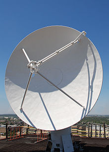
The current antenna is a parabolic solid with a 4.88 metres (16.0 ft) diameter. It is situated 172.5 metres (566 ft) above mean sea level. [8] It rotates at 2.5 RPM (15 degrees per second) or 4.5 RPM maximum (27 degrees per second). Elevation can be set from -1 to 90 degrees.
The transmitter is an Enterprise Electronics DWSR-88S, operating on a wavelength of 10.56 cm (corresponding to 2840MHz). This frequency is in the S band, which is also used by the NEXRAD network. Peak power is 1 megawatt. [1]
Texas A&M University is also a partner in the Smart-R mobile research radars. See the following for more information - https://web.archive.org/web/20060418035945/http://www.met.tamu.edu/smartr/Smart-R.html

A tornado warning is a public warning that is issued to an area in the direct path of a tornado or a thunderstorm capable of producing a tornado. They are issued by weather forecasting agencies in some countries when an actual tornado or signs of a developing tornado, such as a funnel cloud or wall cloud, are reported by weather spotters, the public, or detected by weather radar.

A severe thunderstorm warning is a type of public warning for severe weather that is issued by weather forecasting agencies worldwide when one or more severe thunderstorms have been detected by Doppler weather radar, observed by weather spotters, or reported by an emergency management agency, law enforcement, or the general public. Unlike a watch, a warning is issued to areas in the direct path of active severe thunderstorms, that are expecting a direct impact typically within an hour. Severe thunderstorms can cause property damage and injury due to large hail, high winds, and flooding due to torrential rainfall. The exact criteria to issue a warning varies from country to country.

NEXRAD or Nexrad is a network of 160 high-resolution S-band Doppler weather radars operated by the National Weather Service (NWS), an agency of the National Oceanic and Atmospheric Administration (NOAA) within the United States Department of Commerce, the Federal Aviation Administration (FAA) within the Department of Transportation, and the U.S. Air Force within the Department of Defense. Its technical name is WSR-88D.

WSR-74 radars were Weather Surveillance Radars designed in 1974 for the National Weather Service. They were added to the existing network of the WSR-57 model to improve forecasts and severe weather warnings. Some have been sold to other countries like Australia, Greece, and Pakistan.
WSR-57 radars were the USA's main weather surveillance radar for over 35 years. The National Weather Service operated a network of this model radar across the country, watching for severe weather.

Weather radar, also called weather surveillance radar (WSR) and Doppler weather radar, is a type of radar used to locate precipitation, calculate its motion, and estimate its type. Modern weather radars are mostly pulse-Doppler radars, capable of detecting the motion of rain droplets in addition to the intensity of the precipitation. Both types of data can be analyzed to determine the structure of storms and their potential to cause severe weather.

A hook echo is a pendant or hook-shaped weather radar signature as part of some supercell thunderstorms. It is found in the lower portions of a storm as air and precipitation flow into a mesocyclone, resulting in a curved feature of reflectivity. The echo is produced by rain, hail, or even debris being wrapped around the supercell. It is one of the classic hallmarks of tornado-producing supercells. The National Weather Service may consider the presence of a hook echo coinciding with a tornado vortex signature as sufficient to justify issuing a tornado warning.
The National Severe Storms Laboratory (NSSL) is a National Oceanic and Atmospheric Administration (NOAA) weather research laboratory under the Office of Oceanic and Atmospheric Research. It is one of seven NOAA Research Laboratories (RLs).
Volumetric Imaging and Processing of Integrated Radar, known by the acronym VIPIR, is an analysis and display program for Doppler weather radar, created and sold by Baron Services. This software allows improved analysis of radar data for private users, in particular television stations, similar to the Weather Decision Support System program used by the National Weather Service.
The AN/CPS-9 radar, the first radar specifically designed for meteorological use, was produced in the United States around 1949 and unveiled by the Air Weather Service in 1954.
The AN/APS-2, originally known as ASG, was a surface search radar developed by Philco originally for use in US Coast Guard blimps to detect German submarines. It proved better than several similar models then being built, and was ordered by the RAF Coastal Command where it was known as ASV Mark V. It was used primarily on British Liberator GR bombers, where they were instrumental in closing the Mid-Atlantic Gap and the subsequent destruction of the German U-boat fleet in May/June 1943.

The WSR-1 or Weather Surveillance Radar-1 was one of the first weather radars and the first used by a civilian organization in the US. The WSR-1 series was a modified version of the AN/APS-2F radar, which the Weather Bureau acquired from the Navy. The WSR-1A, WSR-3, and WSR-4 were also variants of this radar. The first WSR-1 in the USA was at Washington National Airport in Washington, D.C. in 1947, and the last WSR-3 was retired by 1978.
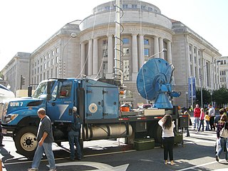
Doppler on Wheels is a fleet of X-band and C-band radar trucks managed by the University of Illinois Urbana-Champaign and previously maintained by the Center for Severe Weather Research (CSWR) in Boulder, Colorado, led by principal investigator (PI) Joshua Wurman, with the funding largely provided by the National Science Foundation (NSF). The DOW fleet and its associated Mobile Mesonets and deployable weather stations (Pods) were Lower Atmospheric Observing Facilities (LAOF) "National Facilities" supporting a wide variety NSF-sponsored research. They are now included in the NSF's "Community Instruments and Facilities" (CIF) program led by PI Karen Kosiba.

The Verification of the Origins of Rotation in Tornadoes Experiment are field experiments that study tornadoes. VORTEX1 was the first time scientists completely researched the entire evolution of a tornado with an array of instrumentation, enabling a greater understanding of the processes involved with tornadogenesis. A violent tornado near Union City, Oklahoma was documented in its entirety by chasers of the Tornado Intercept Project (TIP) in 1973. Their visual observations led to advancement in understanding of tornado structure and life cycles.
Terminal Doppler Weather Radar (TDWR) is a Doppler weather radar system with a three-dimensional "pencil beam" used primarily for the detection of hazardous wind shear conditions, precipitation, and winds aloft on and near major airports situated in climates with great exposure to thunderstorms in the United States. As of 2011, all were in-service with 45 operational radars, some covering multiple airports in major metropolitan locations, across the United States & Puerto Rico. Several similar weather radars have also been sold to other countries such as China (Hong Kong). Funded by the United States Federal Aviation Administration (FAA), TDWR technology was developed in the early 1990s at Lincoln Laboratory, part of the Massachusetts Institute of Technology, to assist air traffic controllers by providing real-time wind shear detection and high-resolution precipitation data.
National Weather Service - Shreveport, LA (SHV) is one of 122 weather forecast offices around the United States. It is responsible for issuing public and aviation forecasts and warning for South Central and Southwestern Arkansas, Southeastern Oklahoma, and Eastern and Northeastern Texas Counties, as well as for North Central and Northwestern Louisiana Parishes. It is co-located with a weather radar (KSHV) of the NEXRAD network and an upper air sounding facility. It controls the issuance of weather information and bulletins on a certain number of NOAA Weather Radio.
The following is a glossary of tornado terms. It includes scientific as well as selected informal terminology.

Multifunction Phased Array Radar (MPAR) was an experimental Doppler radar system that utilized phased array technology. MPAR could scan at angles as high as 60 degrees in elevation, and simultaneously track meteorological phenomena, biological flyers, non-cooperative aircraft, and air traffic. From 2003 through 2016, there was one operational MPAR within the mainland United States—a repurposed AN/SPY-1A radar set loaned to NOAA by the U.S. Navy. The MPAR was decommissioned and removed in 2016.
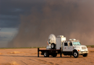
The Shared Mobile Atmospheric Research and Teaching Radar, colloquially known as SMART-R or SR, is a mobile Doppler weather radar platform operated and created by University of Oklahoma (OU) with aide from Texas A&M and Texas Tech University in 2001.
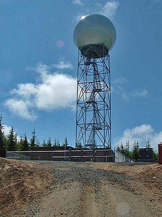
The Langley Hill Doppler radar (KLGX) is a National Weather Service NEXRAD Doppler weather radar station on the Pacific coast of Washington State, in the United States. Prior to its construction, Washington's Olympic Peninsula coast was the only portion of the U.S. coastline without weather radar coverage, and "virtually no radar coverage [is] available over the ocean, where the majority of western Washington's weather originates" according to a Weather Service report to the United States Congress.