Aguilar, Pangasinan

Last updated
Aguilar
Municipality of Aguilar
Aguilar, Pangasinan, Philippines - panoramio (1).jpg
Street in Aguilar
Aguilar Pangasinan.png
Ph locator pangasinan aguilar.png
Map of Pangasinan with Aguilar highlighted
OpenStreetMap
Aguilar, Pangasinan
Philippines location map (square).svg
Red pog.svg
Aguilar
Location within the Philippines
Coordinates: 15°53′24″N120°14′16″E / 15.889886°N 120.237853°E / 15.889886; 120.237853
Country Philippines
Region Ilocos Region
Province Pangasinan
District 2nd district
Founded July 16, 1805
Named for Rafael María de Aguilar
Barangays 16 (see Barangays)
Government
[1]
  Type Sangguniang Bayan
   Mayor Roldan C. Sagles
   Vice Mayor Jesus M. Zamuco Jr.
   Representative Jumel Anthony I. Espino
   Municipal Council
Members
   Electorate 29,400 voters (2022)
Area
[2]
  Total195.07 km2 (75.32 sq mi)
Elevation
41 m (135 ft)
Highest elevation
360 m (1,180 ft)
Lowest elevation
2 m (7 ft)
Population
 (2020 census) [3]
  Total45,100
  Density230/km2 (600/sq mi)
   Households
9,934
Economy
   Income class 3rd municipal income class
   Poverty incidence
16.22
% (2018) [4]
   Revenue 165.7 million (2020)
   Assets 446.4 million (2020)
   Expenditure 172.1 million (2020)
   Liabilities 52.86 million (2020)
Service provider
  ElectricityCentral Pangasinan Electric Cooperative (CENPELCO)
Time zone UTC+8 (PST)
ZIP code
2415
PSGC
IDD : area code +63(0)75
Native languages Pangasinan
Ilocano
Tagalog
Website www.aguilar-pangasinan.gov.ph

Aguilar, officially the Municipality of Aguilar (Pangasinan : Baley na Aguilar; Ilocano : Ili ti Aguilar; Tagalog : Bayan ng Aguilar), is a 3rd class municipality in the province of Pangasinan, Philippines. According to the 2020 census, it has a population of 45,100 people. [3]

Contents

The municipality was named after Spanish governor-general Rafael María de Aguilar, who ordered the establishment of an independent civil political unit on 16 July 1805.

Aguilar is 16 kilometres (9.9 mi) from provincial capital Lingayen and 190 kilometres (120 mi) from Manila.

History

The Municipality of Aguilar had its early beginnings as cattle ranch founded by the Spaniards. The place was known then as Sitio Balubad, which was then still part of the town of Binalatongan (now San Carlos). On the western part were the Zambales Mountains with thick forests and verdant foliage. It was hunter's paradise with deer roaming here and there with an occasional wild boar making an appearance. The grass in the plains were succulent fare for fattening cattle and the water from the brooks and streams clear and sparkling. On the eastern part was the Agno River. At that time, there were no roads were yet established. There were footpaths which eventually roads providing access from one place to another. The river arteries constituted the main mode of transportation in the interior towns. Through these river systems, boats sailed from the Ilocos provinces in the North southwards to Dagupan, Calasiao, Lingayen and sometimes even as far as San Isidro De Labrador, Salasa, Aguilar and Camiling. Worth noting was the fossiliferous river bank in Camiling useful in making lime, while mineral waters consisting of ferruginous and alkaline waters were and are still found in Aguilar and Mangatarem. As a thriving place for cattle and bountiful rice harvests, it was natural for Aguilar to attract people from other towns to stay and settle in the place. The early settlers prospered and lived in peace and contentment. When the Spaniards in Lingayen heard of this flourishing village, they sent Spanish explorers through the town of Salasa to visit the place. Some Spanish soldiers and priest were left to organize a pueblo. In time, the clamor to convert the settlement into a town became popular. A petition was therefore, filed with the principales or municipal officials of Binalatongan to convert the village into a town. The petition was finally favorably endorsed.

The decree establishing Aguilar as an independent civil political unit was issued on 16 July 1805 by Governor General Rafael Maria de Aguilar, after whom the town was named. The decree in Lingayen on 1 August 1805. However, it was not until 19 January 1806 that the Provincial Governor of Pangasinan was able to make the trip to the sitio of Balubad, the site of the Poblacion, to carry out the provisions of the decree. The Governor inspected the area, chose the most appropriate site on which to erect the town center and listed the people who wishes to settle in the new town, together with their places of origin. The greatest number came from Lingayen, made up of 210 couples and 60 individuals from the "gremio de naturals" (native community) and 10 couples and 11 individuals from the "gremio de mestizos" (mestizo community). From the town of Salasa, there were 56 couples and 21 bachelors all of the rank of "Caylianes" (commoners), while from the town of San Carlos, there were 32 couples and 19 individuals, all "Caylianes". There were also Ilocano migrants consisting of 6 couples and 24 bachelors. Finally, there were some Negritos, consisting of both baptized Christians and Ynfieles (Non-Christians). All in all, the total number of inhabitants composed 401 tributes, for bachelors and unmarried women paid only half a tribute each. These excluded the unbaptized negritos. The town was formally inaugurated on 9 May 1806 when the first officials were elected and given their appointments by the Alcalde Mayor. The officials were headed by Don Francisco Zamuco as Gobernadorcillo and Don Juan Manguino as "Teniente Primero" (first lieutenant). The Alcalde Mayor then proceeded to mark the jurisdictional limits of the new town. With the town of Salasa, the boundary was the river Balubad (now Sobol) from the mountain where the river originated to the river Agno, running a direct line from west to east. With the town of San Carlos, the boundary was the Agno River in the east and the Bunlalacao River in the south. The necessary boundary markers were placed and operations were witnessed by the town officials of Salasa and San Carlos. Mangatarem as a town did not yet exist, having been founded only in 1837. Local folklores likewise maintained that Aguilar was identified with an eagle or agila that used to fly around the place at nighttime and would perch on a fence or alar when tired of flying, hence, agila and alar put together formed Aguilar. [5]

Leadership by the Principales

Although the population of Aguilar was drawn from different places, the leadership of the town was furnished by the elite families, the principales who had moved from Lingayen to Aguilar in 1805. Aguilar also had a large number of Ilocano migrants among the population. Their tributes in fact contributed to the political viability of the new town. But in all these new towns, the initiative for and leadership in building the new town came from the Pangasinan native-born elite.

Polos or Forced Labor in Local Infrastructures

The Gobernadorcillo usually took charge of public works and improvements in the town. This included the building and repair of public structures, including churches and convents, as well as construction and repair of roads and bridges under the parish curate's supervision. For this purpose, the services of Caylianes were utilized. They were required to render 40 days of labor or Polos a year. The Gobernadorcillo also had to procure building materials from the town if possible; if not he had to send a request for approval to the Superior Government in Manila through Alcalde Mayor. He must also keep clean and sanitary the casa tribunal and the public jail.

Geography

Barangays

Aguilar is politically subdivided into 16 barangays. [6] Each barangay consists of puroks and some have sitios.

  • Bayaoas
  • Baybay
  • Bocacliw
  • Bocboc East
  • Bocboc West
  • Buer
  • Calsib
  • Niñoy
  • Poblacion
  • Pogomboa
  • Pogonsili
  • San Jose
  • Tampac
  • Laoag
  • Manlocboc
  • Panacol

Climate

Climate data for Aguilar, Pangasinan
MonthJanFebMarAprMayJunJulAugSepOctNovDecYear
Average high °C (°F)31
(88)
31
(88)
31
(88)
33
(91)
32
(90)
32
(90)
30
(86)
30
(86)
30
(86)
31
(88)
31
(88)
31
(88)
31
(88)
Average low °C (°F)21
(70)
21
(70)
22
(72)
24
(75)
24
(75)
24
(75)
25
(77)
23
(73)
23
(73)
23
(73)
23
(73)
22
(72)
23
(73)
Average precipitation mm (inches)5.1
(0.20)
11.6
(0.46)
21.1
(0.83)
27.7
(1.09)
232.9
(9.17)
350.8
(13.81)
679.8
(26.76)
733.1
(28.86)
505
(19.9)
176.6
(6.95)
67.2
(2.65)
17.7
(0.70)
2,828.6
(111.38)
Average rainy days333414182325221584142
Source: World Weather Online [7]

Demographics

Population Census of Aguilar
YearPop.±% p.a.
1903 4,763    
1918 6,006+1.56%
1939 8,178+1.48%
1948 10,587+2.91%
1960 14,125+2.43%
1970 17,696+2.28%
1975 19,853+2.33%
1980 22,080+2.15%
1990 27,303+2.15%
1995 30,578+2.15%
2000 33,213+1.79%
2007 36,564+1.33%
2010 39,529+2.88%
2015 41,463+0.91%
2020 45,100+1.67%
Source: Philippine Statistics Authority [8] [9] [10] [11]

Economy

Aguilar Public Market interior AguilarPangasinanjf823.JPG
Aguilar Public Market interior

Because of the majority of vast farmlands in Aguilar, The major crops planted in the municipality are Rice, Corn, Vegetables, Mangoes, Luffas and other crops. Aguilar is also engages in Poultry and Livestock Raising including Cows, Pigs, Carabaos, Goats, Chickens and Domestic Ducks. Tourism is also a booming industry in the municipality due to the sudden growth of tourists visiting; due to this, various resorts has been established in various locations.

Government

Local government

Aguilar, belonging to the second congressional district of the province of Pangasinan, is governed by a mayor designated as its local chief executive and by a municipal council as its legislative body in accordance with the Local Government Code. The mayor, vice mayor, and the councilors are elected directly by the people through an election which is being held every three years.

Elected officials

Members of the Municipal Council
(2019–2022) [19]
PositionName
CongressmanJumel Anthony I. Espino
MayorRoldan C. Sagles
Vice-MayorJesus M. Zamuco Jr.
CouncilorsEvelyn G. Villanueva
Kristal B. Soriano
Jessie S. Posadas
Renato L. Cervantes
Defin R. Dumlao
Magdalena O. Sison
Angelo Y. Limos
Crispin B. Repato Jr.

Tourism

Facade of Saint Joseph the Patriarch Parish Church Facade of Saint Joseph the Patriarch Parish Church, Aguilar, Pangasinan.jpg
Facade of Saint Joseph the Patriarch Parish Church

There are many tourist spots in Aguilar, some of which are:

The Kalinaw Bridge of Hiraya at twilight. Kalinaw Bridge of Hiraya.jpg
The Kalinaw Bridge of Hiraya at twilight.
Boating at Hiraya's Kalinaw Lagoon BOATING at Hiraya.jpg
Boating at Hiraya's Kalinaw Lagoon

HIRAYA WELLNESS.jpg

Pizza Bianca ala Filipina from Tio's Pizza bianca ala filipina.jpg
Pizza Bianca ala Filipina from Tio's
Seafood Boodle from Tio's Seafood Boodle .jpg
Seafood Boodle from Tio's

Education

High Schools:

Elementary Schools:

Private Schools:

Related Research Articles

<span class="mw-page-title-main">Binmaley</span> Municipality in Pangasinan, Philippines

Binmaley, officially the Municipality of Binmaley, is a 1st class municipality in the province of Pangasinan, Philippines. According to the 2020 census, it has a population of 86,881 people.

<span class="mw-page-title-main">Anda, Pangasinan</span> Municipality in Pangasinan, Philippines

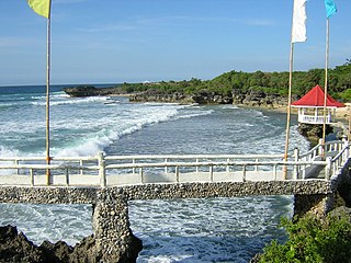
Anda, officially the Municipality of Anda, is a 3rd class municipality in the province of Pangasinan, Philippines. Unique in this part of the province, The Sambalic language of Bolinao or Binubolinao is primarily spoken in the municipality and the adjacent town of Bolinao. According to the 2020 census, it has a population of 41,548 people.

<span class="mw-page-title-main">Pangasinan</span> Province in Ilocos Region, Philippines

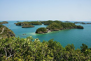
Pangasinan, officially the Province of Pangasinan, is a coastal province in the Philippines located in the Ilocos Region of Luzon. Its capital is Lingayen. Pangasinan is in the western area of Luzon along Lingayen Gulf and the South China Sea. It has a total land area of 5,451.01 square kilometres (2,104.65 sq mi). According to the 2020 census it has a population of 3,163,190. The official number of registered voters in Pangasinan is 1,651,814. The western portion of the province is part of the homeland of the Sambal people, while the central and eastern portions are the homeland of the Pangasinan people. Due to ethnic migration, the Ilocano people settled in the province.

<span class="mw-page-title-main">Agno, Pangasinan</span> Municipality in Pangasinan, Philippines

Agno, officially the Municipality of Agno, is a 3rd class municipality in the province of Pangasinan, Philippines. According to the 2020 census, it has a population of 29,947 people.

<span class="mw-page-title-main">Bani, Pangasinan</span> Municipality in Pangasinan, Philippines

Bani, officially the Municipality of Bani, is a 2nd class municipality in the province of Pangasinan, Philippines. According to the 2020 census, it has a population of 52,603 people.

<span class="mw-page-title-main">Bautista, Pangasinan</span> Municipality in Pangasinan, Philippines

Bautista, officially the Municipality of Bautista, is a 4th class municipality in the province of Pangasinan, Philippines. According to the 2020 census, it has a population of 35,398 people.

<span class="mw-page-title-main">Binalonan</span> Municipality in Pangasinan, Philippines

Binalonan, officially the Municipality of Binalonan, is a 1st class municipality in the province of Pangasinan, Philippines. According to the 2020 census, it has a population of 56,382 people.

<span class="mw-page-title-main">Bolinao</span> Municipality in Pangasinan, Philippines

Bolinao, officially the Municipality of Bolinao, is a 1st class municipality in the province of Pangasinan, Philippines. According to the 2020 census, it has a population of 83,979 people.

<span class="mw-page-title-main">Bugallon</span> Municipality in Pangasinan, Philippines

Bugallon, officially the Municipality of Bugallon, is a 2nd class municipality in the province of Pangasinan, Philippines. According to the 2020 census, it has a population of 74,962 people.

<span class="mw-page-title-main">Burgos, Pangasinan</span> Municipality in Pangasinan, Philippines

Burgos, officially the Municipality of Burgos, is a 4th class municipality in the province of Pangasinan, Philippines. According to the 2020 census, it has a population of 23,749 people.

<span class="mw-page-title-main">Infanta, Pangasinan</span> Municipality in Pangasinan, Philippines

Infanta, officially the Municipality of Infanta, is a 3rd class municipality in the province of Pangasinan, Philippines. According to the 2020 census, it has a population of 26,242 people.

<span class="mw-page-title-main">Labrador, Pangasinan</span> Municipality in Pangasinan, Philippines

Labrador, officially the Municipality of Labrador, is a 4th class municipality in the province of Pangasinan, Philippines. According to the 2020 census, it has a population of 26,811 people.

<span class="mw-page-title-main">Lingayen</span> Municipality in Pangasinan, Philippines

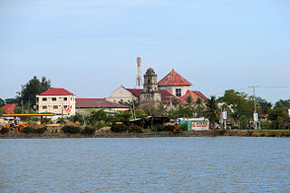
Lingayen, officially the Municipality of Lingayen, is a 1st class municipality and capital of the province of Pangasinan, Philippines. According to the 2020 census, it has a population of 107,728 people.

<span class="mw-page-title-main">Manaoag</span> Municipality in Pangasinan, Philippines

Manaoag, officially the Municipality of Manaoag, is a 1st class municipality in the province of Pangasinan, Philippines. According to the 2020 census, it has a population of 76,045 people.

<span class="mw-page-title-main">Pozorrubio</span> Municipality in Pangasinan, Philippines

Pozorrubio, officially the Municipality of Pozorrubio, is a 1st class municipality in the province of Pangasinan, Philippines. According to the 2020 census, it has a population of 74,729 people.

<span class="mw-page-title-main">Santa Barbara, Pangasinan</span> Municipality in Pangasinan, Philippines

Santa Barbara, officially the Municipality of Santa Barbara, is a 1st class municipality in the province of Pangasinan, Philippines. According to the 2020 census, it has a population of 92,187 people.

<span class="mw-page-title-main">Santa Maria, Pangasinan</span> Municipality in Pangasinan, Philippines

Santa Maria, officially the Municipality of Santa Maria, is a 4th class municipality in the province of Pangasinan, Philippines. According to the 2020 census, it has a population of 34,220 people.

<span class="mw-page-title-main">Santo Tomas, Pangasinan</span> Municipality in Pangasinan, Philippines

Santo Tomas, officially the Municipality of Santo Tomas, is a 5th class municipality in the province of Pangasinan, Philippines. According to the 2020 census, it has a population of 14,878 people.

<span class="mw-page-title-main">Sual</span> Municipality in Pangasinan, Philippines

Sual, officially the Municipality of Sual, is a 1st class municipality in the province of Pangasinan, Philippines. According to the 2020 census, it has a population of 39,091 people.

<span class="mw-page-title-main">Nampicuan</span> Municipality in Nueva Ecija, Philippines

Nampicuan, officially the Municipality of Nampicuan, is a 5th class municipality in the province of Nueva Ecija, Philippines. According to the 2020 census, it has a population of 14,471 people.

References

  1. Municipality of Aguilar | (DILG)
  2. "2015 Census of Population, Report No. 3 – Population, Land Area, and Population Density" (PDF). Philippine Statistics Authority. Quezon City, Philippines. August 2016. ISSN   0117-1453. Archived (PDF) from the original on May 25, 2021. Retrieved July 16, 2021.
  3. 1 2 Census of Population (2020). "Region I (Ilocos Region)". Total Population by Province, City, Municipality and Barangay. Philippine Statistics Authority . Retrieved 8 July 2021.
  4. "PSA Releases the 2018 Municipal and City Level Poverty Estimates". Philippine Statistics Authority. 15 December 2021. Retrieved 22 January 2022.
  5. Aguilar Archived 2011-10-28 at the Wayback Machine . The Official Website of the Province of Pangasinan and its People. Retrieved April 9, 2012
  6. "Province: PANGASINAN". PSGC Interactive. Makati City, Philippines: National Statistical Coordination Board. Archived from the original on 14 November 2012. Retrieved 26 November 2012.
  7. "Aguilar, Pangasinan: Average Temperatures and Rainfall". World Weather Online. Retrieved 23 September 2015.
  8. Census of Population (2015). "Region I (Ilocos Region)". Total Population by Province, City, Municipality and Barangay. Philippine Statistics Authority . Retrieved 20 June 2016.
  9. Census of Population and Housing (2010). "Region I (Ilocos Region)". Total Population by Province, City, Municipality and Barangay. National Statistics Office . Retrieved 29 June 2016.
  10. Censuses of Population (1903–2007). "Region I (Ilocos Region)". Table 1. Population Enumerated in Various Censuses by Province/Highly Urbanized City: 1903 to 2007. National Statistics Office.
  11. "Province of Pangasinan". Municipality Population Data. Local Water Utilities Administration Research Division. Retrieved 17 December 2016.
  12. "Poverty incidence (PI):". Philippine Statistics Authority. Retrieved December 28, 2020.
  13. Error: Unable to display the reference properly. See the documentation for details.
  14. Error: Unable to display the reference properly. See the documentation for details.
  15. Error: Unable to display the reference properly. See the documentation for details.
  16. Error: Unable to display the reference properly. See the documentation for details.
  17. Error: Unable to display the reference properly. See the documentation for details.
  18. "PSA Releases the 2018 Municipal and City Level Poverty Estimates". Philippine Statistics Authority. 15 December 2021. Retrieved 22 January 2022.
  19. "2019 National and Local Elections" (PDF). Commission on Elections. Retrieved March 6, 2022.