
Mobile Bay is a shallow inlet of the Gulf of Mexico, lying within the state of Alabama in the United States. Its mouth is formed by the Fort Morgan Peninsula on the eastern side and Dauphin Island, a barrier island on the western side. The Mobile River and Tensaw River empty into the northern end of the bay, making it an estuary. Several smaller rivers also empty into the bay: Dog River, Deer River, and Fowl River on the western side of the bay, and Fish River on the eastern side. Mobile Bay is the fourth-largest estuary in the United States with a discharge of 62,000 cubic feet (1,800 m3) of water per second. Annually, and often several times during the summer months, the fish and crustaceans will swarm the shallow coastline and shore of the bay. This event, appropriately named a jubilee, draws a large crowd because of the abundance of fresh, easily caught seafood.

Marengo County is a county located in the west central portion of the U.S. state of Alabama. As of the 2020 census, the population was 19,323. The largest city is Demopolis, and the county seat is Linden. It is named in honor of the Battle of Marengo near Turin, Italy, where French leader Napoleon Bonaparte defeated the Austrians on June 14, 1800.

Forkland is a town in Greene County, Alabama, United States. At the 2020 census, the population was 445. It was incorporated around 1974.

Demopolis is the largest city in Marengo County, in west-central Alabama. The population was 7,162 at the 2020 census.
Linden is a city in and the county seat of Marengo County, Alabama, United States. The population was 1,930 at the 2020 census, down from 2,123 at the 2010 census.

The University of Alabama, the state's oldest continuously public university, is a senior comprehensive doctoral-level institution located in Tuscaloosa, Alabama.

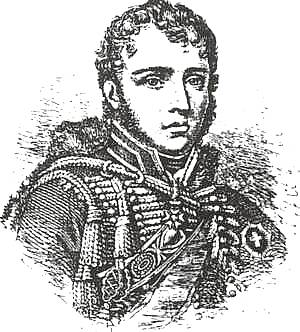
Charles, comte Lefebvre-Desnouettes or Lefèbvre-Desnoëttes became a French officer during the French Revolutionary Wars and a general during the Napoleonic Wars. He later emigrated to the United States.

Cahaba, also spelled Cahawba, was the first permanent state capital of Alabama from 1820 to 1825. It was the county seat of Dallas County, Alabama until 1866. Located at the confluence of the Alabama and Cahaba rivers, the town endured regular seasonal flooding.
François Antoine "Charles" Lallemand was a French general who served Napoleon I of France, tried to found a colony in what is now Texas, and finally returned to France to serve as governor of Corsica.

Blakeley is a ghost town in Baldwin County, Alabama, United States. During the height of its existence, Blakeley was a thriving town which flourished as a competitor to its western neighbor, Mobile. Blakeley was the county seat for Baldwin County from 1820 until 1868, when the county government was moved south to Daphne. It was the location of a major fort during the Civil War. One of the last battles of the Civil War was fought here in April 1865, as Union soldiers overran Confederates. The town is now in an Alabama historic state park known as Historic Blakeley State Park, north of Spanish Fort.
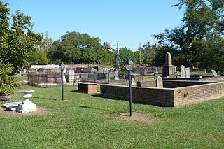
Church Street Graveyard is a historic city cemetery located in Mobile, Alabama. The cemetery is situated on 4 acres (1.6 ha) and is surrounded by a brick wall that dates to 1830. At the time that the cemetery was established, it lay about a half-mile away from most development, but it is now considered to be downtown.

The Vine and Olive Colony was an effort by a group of French Bonapartists who, fearing for their lives after the fall of Napoleon Bonaparte and the Bourbon Restoration, attempted to establish an agricultural settlement growing wine grapes and olive trees in the Alabama wilderness. The area that they settled later became the counties of Marengo and Hale.

White Bluff, also known as Ecor Blanc, is a historic site located along the Tombigbee River in Demopolis, Alabama. It is a chalk cliff, roughly one mile long, that is composed of a geological layer known as the Demopolis Chalk Formation, part of the Selma Group. The upper portions of the cliff stood almost 80 feet (24 m) above the river before the construction of the Demopolis Lock and Dam downriver. It now averages about 30 feet (9.1 m) above the river.

Demopolis Regional Airport is a city-owned, public-use airport located six nautical miles southwest of the central business district of Demopolis, a city in Marengo County, Alabama, United States. It is also known as Demopolis Municipal Airport and Julian D. "Buzz" Sawyer Airport.

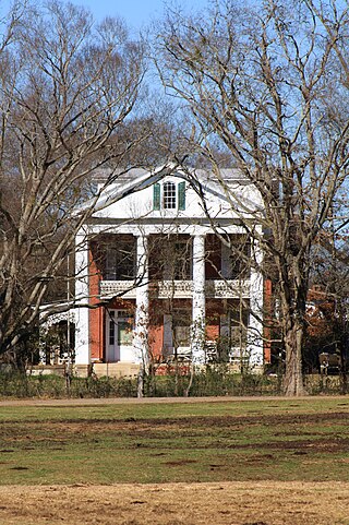
Rosemount is a historic plantation house near Forkland, Alabama. The Greek Revival style house was built in stages between 1832 and the 1850s by the Glover family. The house has been called the "Grand Mansion of Alabama." The property was added to the National Register of Historic Places on May 27, 1971. The Glover family enslaved over 300 people from 1830 until 1860.

Thornhill is a historic plantation near Forkland, Alabama. The Greek Revival main house was built in 1833 by James Innes Thornton. The house was placed on the National Register of Historic Places on May 10, 1984.
The Alfred Hatch Place at Arcola, also known as the Arcola Plantation and locally as the Half-house, is a historic plantation house and historic district on the Black Warrior River several miles northwest of Gallion, Alabama.

Champ d'Asile was a short-lived settlement founded in Texas in January 1818 by 20 French Bonapartist veterans of the Napoleonic Wars from the Vine and Olive Colony. The party was led by General Charles Lallemand. Land was offered to French settlers on March 3, 1817, after a vote by the United States Congress. Champ d'Asile was situated along the Trinity River and was abandoned in July of the same year.

Arcola is a ghost town on the Black Warrior River in what is now Hale County, formerly Marengo County, Alabama. Named to honor the French victory during the Battle of Arcola, it was established in the early 1820s by former French Bonapartists as part of their Vine and Olive Colony, after they were forced to abandon their first town at Demopolis and many found Aigleville unsuitable. The first settler at the site was Frederic Ravesies, who established himself at what later became the Hatch Plantation. Although never more than a village, Arcola became the largest settlement in the colony. Beginning in the 1830s American settlers moved into the area and purchased most of the former French land grants, primarily using Arcola as a river landing. By the 1850s the French settlement had disappeared, replaced by a community of adjoining plantations.

Spring Hill is a neighborhood of Mobile, in Mobile County, Alabama. Located on a tall broad hill 6 miles (10 km) to the west of downtown Mobile, it has one of the highest elevations in the area. Originally a summer retreat community, it was eventually encompassed and annexed by the City of Mobile after 1820. It gained its name from a number of natural springs at the site.


