Fishbourne Roman Palace is located in the village of Fishbourne, Chichester in West Sussex. The palace is the largest Roman residence north of the Alps, and has an unusually early date of 75 AD, around thirty years after the Roman conquest of Britain.

Bedale is a market town and civil parish in the district of Hambleton, North Yorkshire, England. Historically part of the North Riding of Yorkshire, it is 34 miles (55 km) north of Leeds, 26 miles (42 km) south-west of Middlesbrough and 7 miles (11 km) south-west of the county town of Northallerton. It was originally in Richmondshire and listed in Domesday Book as part of Catterick wapentake, which was also known as Hangshire (named after Hang Bank in Finghall; it was split again and Bedale remained in East Hang. Bedale Beck is a tributary of the River Swale, which forms one of the Yorkshire Dales, with its predominance of agriculture and its related small traditional trades, although tourism is increasingly important.

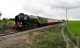
The Wensleydale Railway is a heritage railway in Wensleydale and Lower Swaledale in North Yorkshire, England. It was built in stages by different railway companies and originally extended to Garsdale railway station on the Settle-Carlisle line. Since 2003, the remaining line has been run as a heritage railway. The line runs 22 miles (35 km) between Northallerton West station, about a fifteen-minute walk from Northallerton station on the East Coast Main Line, and Redmire.

Butser Ancient Farm is an archaeological open-air museum and experimental archaeology site located near Petersfield in Hampshire, southern England. Butser features experimental reconstructions of prehistoric, Romano-British and Anglo-Saxon buildings. Examples of Neolithic dwellings, Iron Age roundhouses, a Romano-British villa and an early Saxon house are on display. The site is used as both a tourist attraction and a site for the undertaking of experimental archaeology. In this latter capacity, it was designed so that archaeologists could learn more about the agricultural and domestic economy in Britain during the millennium that lasted from circa 400 BCE to 400 CE, in what was the Late British Iron Age and Romano-British periods.

Aiskew is a village in the civil parish of Aiskew and Leeming Bar, in the Hambleton District of North Yorkshire, England. The village is situated to the immediate north-east of Bedale and separated from it by Bedale Beck.

The A6055 is a 25-mile (40 km) stretch of road in North Yorkshire that runs from Knaresborough to Boroughbridge, with a break, then starts up again at Junction 50 of the A1(M) to run parallel with A1(M) acting as a Local Access Road (LAR) going between Junction 50 and 56 at Barton. Responsibility for the route rests with the Highways Agency, as it is designated as a primary route associated with the A1(M) upgrade.

Leeming Bar railway station is a railway station in Leeming Bar, North Yorkshire, England. It is the eastern rail passenger terminus of the Wensleydale Railway, though the line continues towards Northallerton. Trains are timed to link in with Dales and District service buses to Northallerton to connect with the National Rail network.

Bedale railway station is on the Wensleydale Railway and serves the town of Bedale in North Yorkshire, England.

Chedworth Roman Villa is located near Chedworth, Gloucestershire, England and is a scheduled monument. It is one of the largest and most elaborate Roman villas so far discovered in Britain and one with the latest occupation beyond the Roman period. The villa was built in phases from the early 2nd century to the 5th century, with the 4th-century construction transforming the building into an elite dwelling arranged around three sides of a courtyard. The 4th-century building included a heated and furnished west wing containing a dining-room (triclinium) with a fine mosaic floor, as well as two separate bathing suites: one for damp-heat and one for dry-heat.

Ambleside Roman Fort is the modern name given to the remains of a fort of the Roman province of Britannia. The ruins have been tentatively identified as Galava, mentioned in the Antonine Itinerary. Dating to the 1st or 2nd century AD, its ruins are located on the northern shore of Windermere at Waterhead, near Ambleside, in the English county of Cumbria, within the boundaries of the Lake District National Park.

Leeming Bar is a village in the civil parish of Aiskew and Leeming Bar, in the Hambleton District of North Yorkshire, England. The village lay on the original Great North Road before being bypassed. It is now home to a large industrial estate and the main operating site of the Wensleydale Railway. It is in the historic North Riding of Yorkshire.

Great Witcombe Roman Villa was a villa built during the Roman occupation of Britain. It is located on a hillside at Great Witcombe, near Gloucester in the English county of Gloucestershire. It has been scheduled as an ancient monument.
Leeming is a village in the Hambleton District of North Yorkshire, England.

The A684 is an A road that runs through Cumbria and North Yorkshire, starting at Kendal, Cumbria and ending at Ellerbeck and the A19 road in North Yorkshire. It crosses the full width of the Yorkshire Dales, passing through Garsdale and the full length of Wensleydale.

Vinovia or Vinovium was a Roman fort and settlement situated just over 1 mile (1.6 km) to the north of the town of Bishop Auckland on the banks of the River Wear in County Durham, England. The fort was the site of a hamlet until the late Middle Ages, but the modern-day village of Binchester is about 2 miles (3 km) to the east, near Spennymoor. The ruins are now known as the Binchester Roman Fort.

Bedale Beck is a river that flows through the eastern end of Wensleydale and passes through Crakehall, Bedale and Leeming before entering the River Swale at a point between Morton-on-Swale and Gatenby. Between source and mouth its length is 25.7 miles (41 km).

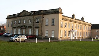
Bedale Hall is a Grade I listed Palladian-style country house in the town of Bedale, North Yorkshire, England.

John Lamplugh Kirk M.R.C.S was a British medical doctor, amateur archaeologist and founder of York Castle Museum in York, North Yorkshire.
Masons Gin is a gin based alcoholic drink distilled by the Mason family in North Yorkshire, England. The brand has won many awards and accolades despite only being set up in 2013. It had a distillery and shop in Aiskew, North Yorkshire, which was moved to a new site in Leeming Bar, after a fire.

Aiskew and Leeming Bar is a civil parish within the Bedale ward of North Yorkshire, England. The parish only has two settlements, but prior to the changes in the 19th century, the area it contains belonged to the parish of Bedale. At the 2011 Census, the population of the parish was 2,427


