
The Amu Darya is a major river in Central Asia and Afghanistan. Rising in the Pamir Mountains, north of the Hindu Kush, the Amu Darya is formed by the confluence of the Vakhsh and Panj rivers, in the Tigrovaya Balka Nature Reserve on the border between Afghanistan and Tajikistan, and flows from there north-westwards into the southern remnants of the Aral Sea. In its upper course, the river forms part of Afghanistan's northern border with Tajikistan, Uzbekistan, and Turkmenistan. In ancient history, the river was regarded as the boundary of Greater Iran with "Turan", which roughly corresponded to present-day Central Asia.

Uzbekistan, officially the Republic of Uzbekistan, is a double-landlocked country in Central Asia. It is surrounded by five landlocked countries: Kazakhstan to the north; Kyrgyzstan to the northeast; Tajikistan to the southeast; Afghanistan to the south, Turkmenistan to the south-west. Its capital and largest city is Tashkent. Uzbekistan is part of the Turkic languages world, as well as a member of the Organisation of Turkic States. Uzbek language is the majority-spoken language in Uzbekistan. Islam is the predominant religion in Uzbekistan, most Uzbeks being Sunni Muslims.
Karakalpakstan, officially the Republic of Karakalpakstan, is an autonomous republic within Uzbekistan. It occupies the whole northwestern part of Uzbekistan. The capital is Nukus. The Republic of Karakalpakstan has an area of 166,590 km2 (64,320 sq mi). Its territory covers the classical land of Khwarezm, which in classical Persian literature was known as کات.
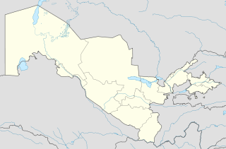
Uzbekistan is divided into 12 regions, 1 autonomous republic, and 1 independent city.
Adelung is a surname. Notable people with the surname include:

Surxondaryo Region, old spelling Surkhandarya Region is a region (viloyat) of Uzbekistan, located in the extreme south-east of the country. Established on March 6, 1941, it borders on Qashqadaryo Region internally, and Turkmenistan, Afghanistan and Tajikistan externally, going anticlockwise from the north. It takes its name from the river Surxondaryo, that flows through the region. It covers an area of 20,100 km². The population is estimated at 2,743,201, with 80% living in rural areas. According to official data, 83% of the population are Uzbeks and 1% Tajiks, but non-official statistics show Surxondaryo is a Persian-speaking area, because most Tajiks of Uzbekistan are concentrated in the Surxondaryo, Samarkand and Bukhara regions. The highest point of the Region and also of Uzbekistan is Khazrati Sulton peak reaching 4,643 m/15,233 ft in Gissar Range.

Bogʻiston, also written as Bagistan, is a village located in the Boʻstonliq District of the Tashkent Region of Uzbekistan. It lies at the southeast of the Charvak Reservoir at 960 m a.s.l. of western extremity of the Koksu Ridge. Practically Bog-i Ston nestles among verdure ashore the river Pskem where it flows into the Charvak Reservoir. "Bog-i Ston" is Tajik for "Land of orchards".

The Menzbier's marmot is a species of rodent in the family Sciuridae from Central Asia. Its name commemorates Russian zoologist Mikhail Aleksandrovich Menzbier.
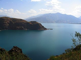
Lake Charvak is a water reservoir in Boʻstonliq District in the northern part of Tashkent Region, Uzbekistan, separating Ugam (north), Pskem (east), and Chatkal (south) ranges. The reservoir was created by erecting a 168 m (551 ft) high stone dam on the river Chirchiq, a short distance downstream from the confluence of Pskem, Koʻksuv and Chatkal rivers in the western Tian Shan mountains, which provide the main volume of water. Currently the confluence cannot be seen and all three rivers discharge directly into Charvak. The reservoir capacity is 2 km3 (0.48 cu mi).

Mount Adelung is the highest peak in Pskem Range in the extreme north-east of the Tashkent Province, Uzbekistan. Mount Adelung is the highest point of Tashkent Province at 4,301 meters, just 2 meters higher than the nearby Mount Beshtor, located a little further to the south-west in the same range, and it is often erroneously identified in various web sources as the "highest point in Uzbekistan". In fact, this honor goes to the Khazret Sultan, a peak with an altitude of 4,643 m in Surkhandarya Province, in the Uzbek part of the Gissar Range, on the border with Tajikistan, which was formerly known as Peak of the 22nd Congress of the Communist Party.

Mount Beshtor rises to 4,299 m in Pskem Range in the north-eastern tip of Uzbekistan's Tashkent Province. Located on the southern border with Kyrgyzstan, a short distance to the south-west from another towering peak in Pskem Range, Mount Adelung. Beshtor is the second highest peak in both Tashkent Province and the Pskem Range.

The Talas Ala-Too or Alataw range is range of the Tian Shan mountains forming the southern and eastern border of Talas Region of Kyrgyzstan. Its western end extends into Kazakhstan, and its south-western end joins the Pskem Mountains and Ugam Range of Uzbekistan. Its eastern end joins the Kirgiz Alatau mountains. To the north is the Talas River valley, and, to the south, Jalal-Abad Region. The highest point is Mount Manas (4484m) near the Uzbek border. There are four major passes along the range. Ötmök pass is the road entrance from the east. The main road from Bishkek to Osh enters from the east over the Ala-Bel pass, passes through the Chychkan State Zoological Reserve and then turns south over another pass into Jalal-Abad province. The Kara-Buura pass (road) and Terek pass lead south into Jalal-Abad provinces.
The Chirchiq or Chirchik is a river of Uzbekistan, a major right tributary of the Syr Darya. It is 155 kilometres (96 mi) in length and its basin has an area of 14,900 square kilometres (5,800 sq mi). The principal tributary is the Ugom (right).
The Pskem or Piskom is a river of Tashkent Region in Uzbekistan in the Pskem Mountains.
The Pskem Mountain Range or Piskom Mountains, is a mountain range located within the west Tien Shan range of Central Asia, and is a natural border between Kyrgyzstan and Uzbekistan. It extends over 160 km (99 mi) from north-east to south-west in the extreme north-eastern finger of Uzbekistan's Tashkent Region. The range is a water divide between the Pskem river to the north and the Chandalash, Chatkal, and Koʻksu rivers to the south. The highest elevations are attained in the north-east of the range: Mount Adelung and Mount Beshtor.
The Chandalash is a river in the Pskem Mountains of Chatkal District in Jalal-Abad Region in western Kyrgyzstan. The river is formed at the south west slope of Talas Alatau and flows into the Chatkal. It is 94 kilometres (58 mi) long, and has a drainage basin of 1,157 square kilometres (447 sq mi). The average annual discharge is 11.7 m3/s (410 cu ft/s). The maximum flow is 30.1 m3/s (1,060 cu ft/s) in June, and the minimum - 2.7 m3/s (95 cu ft/s) - 2.8 m3/s (99 cu ft/s) in March.

Boʻstonliq is a district of Tashkent Region in Uzbekistan. The capital lies at the city Gʻazalkent. It had 171,200 inhabitants in 2021.
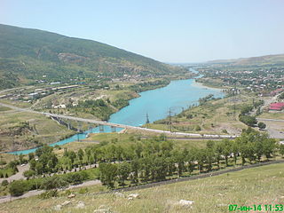
Chorvoq is an urban-type settlement in Boʻstonliq District, Tashkent Region, Uzbekistan. The town is 575 metres above sea level and lies on the river Chirchiq, downstream from Lake Charvak, an irrigation and hydroelectric facility.

Ugam Range is a mountain range in South Kazakhstan Region of Kazakhstan and Tashkent Region in Uzbekistan. It is part of Western Tian Shan. The range runs from northeast to southwest; in the northeast, it joins the Talas Alatau; in the southwest, it gradually flattens towards the valley of the Syr Darya. The total length of Ugam Range is approximately 100 kilometres (62 mi), the highest peaks are over 4,000 metres (13,000 ft). It marks the border between Kazakhstan and Uzbekistan.
The Obi-Rakhmat Grotto is a Middle Paleolithic prehistoric site that yielded Neanderthal fossils. It is a shallow karst cave near the junction of the Chatkal and Pskem Rivers at the southwestern end of the Talassky Alatau Range in the Tien Shan Mountains, 100 km (62 mi) northeast of Tashkent, Uzbekistan.
