
The Amu Darya is a major river in Central Asia and Afghanistan. Rising in the Pamir Mountains, north of the Hindu Kush, the Amu Darya is formed by the confluence of the Vakhsh and Panj rivers, in the Tigrovaya Balka Nature Reserve on the border between Afghanistan and Tajikistan, and flows from there north-westwards into the southern remnants of the Aral Sea. In its upper course, the river forms part of Afghanistan's northern border with Tajikistan, Uzbekistan, and Turkmenistan. In ancient history, the river was regarded as the boundary of Greater Iran with "Turan", which roughly corresponded to present-day Central Asia. The Amu Darya has a flow of about 70 cubic kilometres per year on average.
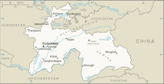
Tajikistan is nestled between Kyrgyzstan and Uzbekistan to the north and west, China to the east, and Afghanistan to the south. Mountains cover 93 percent of Tajikistan's surface area. The two principal ranges, the Pamir Mountains and the Alay Mountains, give rise to many glacier-fed streams and rivers, which have been used to irrigate farmlands since ancient times. Central Asia's other major mountain range, the Tian Shan, skirts northern Tajikistan. Mountainous terrain separates Tajikistan's two population centers, which are in the lowlands of the southern and northern sections of the country. Especially in areas of intensive agricultural and industrial activity, the Soviet Union's natural resource utilization policies left independent Tajikistan with a legacy of environmental problems.

The Aral Sea was an endorheic lake lying between Kazakhstan in the north and Uzbekistan in the south which began shrinking in the 1960s and had largely dried up by the 2010s. The name roughly translates as "Sea of Islands", referring to over 1,100 islands that had dotted its waters. In the Mongolic and Turkic languages, aral means "island, archipelago". The Aral Sea drainage basin encompasses Uzbekistan and parts of Tajikistan, Turkmenistan, Kyrgyzstan, Kazakhstan, Afghanistan, and Iran.

The Syr Darya, historically known as the Jaxartes, is a river in Central Asia. The name, which is Persian, literally means Syr Sea or Syr River. It originates in the Tian Shan Mountains in Kyrgyzstan and eastern Uzbekistan and flows for 2,256.25 kilometres (1,401.97 mi) west and north-west through Uzbekistan and southern Kazakhstan to the northern remnants of the Aral Sea. It is the northern and eastern of the two main rivers in the endorheic basin of the Aral Sea, the other being the Amu Darya (Jayhun).
Gihon is the name of the second river mentioned in the second chapter of the biblical Book of Genesis. The Gihon is mentioned as one of four rivers issuing out of the Garden of Eden that branched from a single river within the garden.

Türkmenabat, formerly and since medieval times Chardzhou, and in ancient times Āmul, is the second-largest city in Turkmenistan and the capital of Lebap Province. As of 2009, it had a population of approximately 254,000 people. From 1924 to 1927 it was briefly renamed Leninsk in honor of Vladimir Lenin.

The North Aral Sea is the portion of the former Aral Sea that is fed by the Syr Darya River. It split from the South Aral Sea in 1987–1988 as water levels dropped due to river diversion for agriculture.

Daryaganj is a neighbourhood of Delhi inside the walled city of Shahjahanabad. The "darya" refers to the river Yamuna which was just outside the walled city. Daryaganj is one of the three sub-divisions and also the administrative headquarters of the Central Delhi District. It starts at Delhi Gate, at the edge of Netaji Subhash Road, which goes towards Red Fort.

The Aydar Lake is part of the man-made Aydar-Arnasay system of lakes, which covers 4,000 square kilometres (1,500 mi2). This has 3 brackish water lakes, deep basins of the south-eastern Kyzyl Kum. The lakes are expansive reservoirs of Soviet planning.

The Kara Darya is a major river in southern Kyrgyzstan and eastern Uzbekistan. It is one of the source rivers of the Syr Darya, the other source river is the Naryn. The Kara Darya is formed by the confluence of the rivers Kara-Kulja and Tar. Its length is 177 kilometres (110 mi), and watershed area 30,100 square kilometres (11,600 sq mi).

Lake Kamyslybas is a large saltwater lake in the Kyzylorda Region, Kazakhstan. It has an area of 176 km2, although the water level in the lake often fluctuates. It has a maximum depth of 10 meters with a coastline 116 km long at an elevation of 58 meters above sea level. It is the largest body of water in the Kamyslybas lake system. It lies in the northern part of Syr Darya's delta, to which it is connected by a canal, and the water level in the lake is affected by fluctuations on the quantity of water from the Syr-Darya. Its salinity can fluctuate significantly, sometimes reaching the point of becoming brine. Lake Kamyslybas is used as a fishery.
Qarqin District is a small boundary district in the northern part of Jowzjan Province, Afghanistan. It borders Turkmenistan to the north along the Amu Darya River, Khamyab District to the west, Mingajik and Mardyan districts to the south, and Balkh Province to the east. The population is 47,000 (2021). The district center is the town of Qarqin, which is situated on the bank of the Amu Darya River.

Pseudoscaphirhynchus is a genus of relatively small, highly threatened sturgeons that are restricted to the Aral Sea system, including the Amu Darya and Syr Darya river basins, in Central Asia.

The dwarf sturgeon, little shovelnose sturgeon, or small Amu-Darya shovelnose sturgeon is a species of fish in the family Acipenseridae. It is found in Turkmenistan, Uzbekistan and probably in Tajikistan.

The Amu Darya sturgeon or false shovelnose sturgeon is a critically endangered species of fish in the family Acipenseridae. It is found in Turkmenistan, Uzbekistan, Tajikistan and perhaps Afghanistan. It inhabits quite shallow flowing waters that are turbid and muddy.

The Zarafshan Range is a mountain range in Tajikistan and Uzbekistan, part of the Pamir-Alay mountains. Almost all of the range belongs to the drainage basins of the Zarafshan River.
The Kunduz River is a tributary of the Amu Darya in northern Afghanistan. It rises in Bamyan Province in the Hindu Kush, and in its upper reaches is also known as the Bamyan River or the Surkhab River. After passing through Baghlan Province and Kunduz Province, the Kunduz River merges into the Amu Darya.
