Related Research Articles

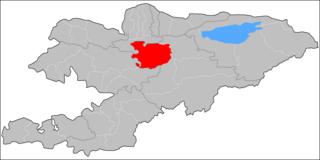
Osh Region is a region (oblast) of Kyrgyzstan. Its capital is Osh, which is not part of the region. It is bounded by (clockwise) Jalal-Abad Region, Naryn Region, China (Xinjiang), Tajikistan, Batken Region, and Uzbekistan. Its total area is 28,934 km2 (11,171 sq mi). The resident population of the region was 1,391,649 as of January 2021. The region has a sizeable Uzbek minority.

The Naryn rises in the Tian Shan mountains in Kyrgyzstan, Central Asia, flowing west through the Fergana Valley into Uzbekistan. Here it merges with the Kara Darya to form the Syr Darya. It is 807 kilometres (501 mi) long and its basin area is 59,100 square kilometres (22,800 sq mi). It has an annual flow of 13.7 cubic kilometres (11,100,000 acre⋅ft).

Kyrgyz Premier League or OLIMPBET Premier League for sponsorship purposes is the division of professional football in Kyrgyzstan. It was created in 1992 after the Dissolution of the Soviet Union. The league is composed of eight teams. The most successful team is Dordoi Bishkek who have won the league thirteen times.

Batken is a district of Batken Region in south-western Kyrgyzstan. Its area is 5,948 square kilometres (2,297 sq mi), and its resident population was 91,983 in 2021. The administrative seat lies at the city Batken, itself not part of the district.
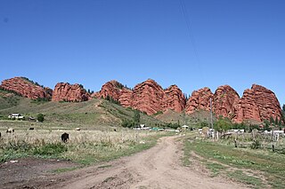
Jeti-Ögüz is a district of Issyk-Kul Region in north-eastern Kyrgyzstan. Its seat lies at Kyzyl-Suu. Its area is 14,499 square kilometres (5,598 sq mi), and its resident population was 93,392 in 2021. It comprises much of the eastern end of the Terskey Ala-Too Range.

Toktogul is a district of Jalal-Abad Region in western Kyrgyzstan. The administrative seat lies at Toktogul. Its area is 7,815 square kilometres (3,017 sq mi), and its resident population was 103,310 in 2021.

At-Bashy is a district of Naryn Region in Kyrgyzstan established in its present borders in 1930. The administrative center is at At-Bashy. Its area is 15,354 square kilometres (5,928 sq mi), and its resident population was 55,771 in 2021. The mountain lake Chatyr-Kul lies in the southwestern part of the district.
Jumgal is a district of Naryn Region in central Kyrgyzstan. The administrative seat lies at Chaek. Its area is 4,803 square kilometres (1,854 sq mi), and its resident population was 44,866 in 2021. It is a mountainous district. Its main rivers are the Kökömeren and its tributaries Jumgal, Suusamyr and Batysh Karakol.
Alay is a district of Osh Region in south-western Kyrgyzstan. The capital lies at Gülchö. The Alay District borders with China in the east, Tajikistan in the south, Chong-Alay District in the west, Nookat District in the north-west, Kara-Suu District and Özgön District in the north, and Kara-Kulja District in the north-east. Its area is 6,821 square kilometres (2,634 sq mi), and its resident population was 87,398 in 2021.

Chong-Alay District is a district of Osh Region in far south-western Kyrgyzstan. The administrative seat lies at Daroot-Korgon. Its area is 4,857 square kilometres (1,875 sq mi), and its resident population was 32,140 in 2021. The Chong-Alay District include 3 rural communities : Chong-Alay, Kashka-Suu, and Jekendi.

Nookat is a district of Osh Region in south-western Kyrgyzstan. Its area is 3,179 square kilometres (1,227 sq mi), and its resident population was 302,481 in 2021. The administrative seat lies at Nookat.

Kara-Buura is a district of Talas Region, in north-western Kyrgyzstan. Its area is 4,216 square kilometres (1,628 sq mi), and its resident population was 69,180 in 2021. The administrative seat lies at Kyzyl-Adyr.
Manas is a district of Talas Region in north-western Kyrgyzstan. Its area is 1,198 square kilometres (463 sq mi), and its resident population was 37,505 in 2021. The administrative seat lies at Pokrovka.

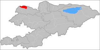
Talas is a district of Talas Region in north-western Kyrgyzstan. Its area is 5,051 square kilometres (1,950 sq mi), and its resident population was 70,642 in 2021. The administrative seat lies at Manas.
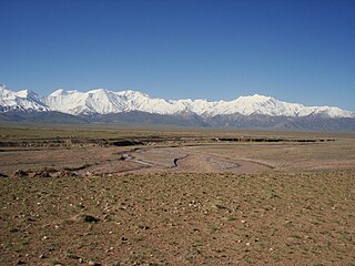
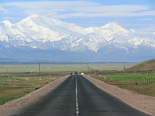
The Alay Valley is a broad, dry valley running east–west across most of southern Osh Region, Kyrgyzstan. It spreads over a length of 174 km (108 mi) east–west. The valley extends in north–south direction with varying width of 27 km (17 mi) in the west, 40 km (25 mi) in the central part, and 3–7 km (1.9–4.3 mi) in the east. The altitude of the valley ranges from 2,440 m (8,010 ft) near Karamyk to 3,536 m (11,601 ft) at Toomurun Pass with an average altitude of about 3,000 m (9,800 ft). The area of the valley is 8,400 km2 (3,200 sq mi). The north side is the Alay Mountains which slope down to the Ferghana Valley. The south side is the Trans-Alay Range along the Tajikistan border, with Lenin Peak,. The western 40 km (25 mi) or so is more hills than valley. On the east there is the low Tongmurun pass and then more valley leading to the Irkestam border crossing to China.
The Kara-Suu or is a right tributary of the Naryn in Aksy District, Jalal-Abad Region, Kyrgyzstan. The river source is in the Chatkal Range, western Tian Shan mountains. It flows through the villages Chaldybar and Jangy-Jol. The river discharges into the Naryn north of Tash-Kömür. It is 85 kilometres (53 mi) long, and the average yearly discharge is 41.2 m3/s (1,450 cu ft/s). Kara-Suu's peak flow is in May, and the minimum flow - in January. The basin area is 2,740 square kilometres (1,060 sq mi). The main tributaries are Ak-Jol, Turduk, Avletim, and Kojata.
Kyzyl-Tuu may refer to the following places in Kyrgyzstan:
This is a list of the extreme points of Kyrgyzstan.