Alamo Placita, Denver

Last updated
The Alamo Placita neighborhood is named for Alamo Placita Park. The street in the foreground is the northbound part of Speer Boulevard. Alamoplacita.JPG
The Alamo Placita neighborhood is named for Alamo Placita Park. The street in the foreground is the northbound part of Speer Boulevard.

Alamo Placita is a historic district and unofficial neighborhood of Denver, Colorado, United States. It is named after Alamo Placita Park which is located on the north side of Speer Boulevard between Ogden and Emerson Streets.

Contents

The district is bounded by Downing Street (east), Speer Boulevard (south), Pennsylvania Street (west), 6th Avenue (north) west of Clarkson Street and 7th Avenue (north) east of Clarkson Street. Alamo Placita is part of a larger official neighborhood called Speer.

History

The history of the Alamo Placita Historic District tells the story of 1860s prairie land along Cherry Creek just three miles (5 km) southeast of the new town of Denver. Farsighted investor Moses Hallett, an attorney from Illinois, bought the land in 1864. Hallett’s quarter section of land became Arlington Park Addition, and later, Alamo Placita neighborhood. By 1887, Denver’s southern city limit was the northern border of Hallett’s claim (now East 6th Avenue). A road on the eastern edge of Hallett’s land, called Hallett Road, is now Downing Street. In 1889, Hallett sold his land to the Arlington Park Land and Improvement Company and became one of several investors in the company.

Robert W. Speer (1855-1918)

Robert W. Speer came to the West in 1878 seeking a cure for his tuberculosis. He recovered and exhibited boundless energy that defied any earlier malaise. Speer is remembered for becoming Denver’s first mayor under home rule in 1904, his three terms as mayor, his exuberance for Denver’s City Beautiful Movement, his support for the Denver park system, his boss-style politics, and his personal gains from real estate investments. Much less well known were Speer’s important connections with the Alamo Placita neighborhood.

Those connections included, first, the fact that Alamo Placita neighborhood was Speer’s first major real estate investment. He formed a syndicate to develop the land. When Arlington Park Addition was created, it became the first client for Speer’s newly formed real estate company. Second, Speer’s creation of an addition and then an amusement park provided him with experience as the central figure in pulling big plans together with powerful Denver men. Third, the neighborhood was his home. Robert and Kate Speer built their residence at 505 Clarkson Street (now demolished) in 1890, and they lived there until 1906.

Arlington Park and Chutes Park

The grand opening for Arlington Park was held on the Fourth of July 1892. An extravagant theatrical production, “The Last Days of Pompeii,” was the main attraction, involving 300 actors and a 54-foothigh set of Mt. Vesuvius. When Mt. Vesuvius erupted, a large fireworks display accompanied the eruption. In true Speer style, the grandeur was heavily promoted and an estimated 12,000 people attended.

The future of Arlington Park looked bright, and surely more events were anticipated. Anticipation disappeared when the 1893 Silver Crash brought the economy to a standstill. In 1898, Arlington Park reopened under the name Chutes Park. The new feature was “the chutes,” a graded waterfall that took riders in boats down into the lake at the bottom.

Two new attractions in May 1899 lured fun seekers. Miss Sadie Boynton, recently of Paris, France, would thrill all by “shooting the chutes” on a bicycle. Also, “Professor Barnes’ muchheralded herd of driving and diving elks” would march up a ramp and plunge, one at a time, off a 60-foot (18 m)-high platform into a tank of water. Handbills proclaimed the park “The Coney Island of the West.”

Fires in 1901 and 1902 closed the amusement park forever, pleasing nearby neighbors who found living near the facility quite trying.

Arlington Park Addition

The 1889 Arlington Park Addition was the first and largest subdivision platted on Moses Hallett’s land. Essentially, it included almost all of the land that was not part of the amusement park. The addition went from E. 6th Avenue to approximately one-half block south of E. 4th Avenue, and from Logan Street to the alley between Corona and Downing Streets.

In January 1890, R.W. Speer and Company began accepting deposits on the property. By the end of February, 319 lots had sold for $217,000. The Rocky Mountain News observed, “R.W. Speer’s smiling face is more smiling than ever.” Notable early investors were Colonel John Arkins, owner of the Rocky Mountain News; John Cochran, the city postmaster; and T.M. Patterson, the first Democratic congressman from the State of Colorado.

The vigorous rate of growth in the Arlington Park Addition stopped in 1893. Building permits were lost for the years 1893 to 1900, but evidence points to a gradual recovery in Arlington Park home building. The new homes tended to be more modest than grand, and the new residents tended to be less well-known citizens. The neighborhood was serving as an affordable destination for new renters and first-time home-owners— particularly first-and second-generation European immigrants. Two groups of immigrants were especially predominant in Arlington Park. Scandinavian immigrants, primarily Swedish, were to make Hallett’s land their home in their new country. And later, Greeks would follow the path of the Swedes.

Half of Colorado’s Swedes lived in the Denver area in 1890. At first the Swedish residents of Alamo Placita were primarily involved in the building trades, domestic service, and gardening, and quite a few Alamo Placita homes were constructed by Swedish craftsmen. Soon, however, the Swedish-Americans began to embrace a variety of occupations. By the early 1930s, Alamo Placita gained significant numbers of Greek-Americans. Most were moving from the environs of their church north of Capitol Hill at E. 37th Avenue and Lafayette Street, the location of the first Greek Orthodox Church in Denver.

In 1933, the Greek Orthodox Church moved to 574 Pennsylvania Street. A residence on the Pennsylvania Street site was demolished and the Greeks built a new Assumption Greek Orthodox Church. The church was designed with the traditional onion-shaped domes associated with Eastern Orthodoxy. The presence of this building brought a rich, new, visible ethnic identity to Alamo Placita. This church was the central Greek church of Colorado. In 1973, the church moved to a spectacular new Assumption Greek Orthodox Church on E. Alameda Avenue.

Alamo Placita Park

Alamo Placita Development After World War II

With the building boom of the post-World War II years taking newer populations to the city fringe or new suburban communities, most of the Alamo Placita neighborhood continued to draw those who needed more affordable housing. Some developers demolished a few early residences to build more lucrative, multifamily apartments. Most of these new apartments were built on a relatively small scale.

According to Assessor records, by 1930 approximately 90 percent of the present Alamo Placita Historic District buildings were built; by 1940, 94 percent were built. These include single-family dwellings, multifamily dwellings, and the few commercial buildings in the district.

Neighborhood development continued with change occurring at a very slow pace, reacting to the ups and downs of the economy. During the 1960s, 1970s, and 1980s, the value of the neighborhood as a family-oriented environment close to the heart of the city was quietly rediscovered by young professionals and others. Lawyers, doctors, teachers, and businesspeople were moving into Alamo Placita in greater numbers, joining trade craftsmen, clerks, salesmen, and others. An example of one such couple is Richard and Dottie Lamm, who lived at 531 Emerson Street in the 1960s, before Lamm became a three-term governor of Colorado. The rediscovery of the neighborhood included an appreciation and respect for its architecture. Growing numbers of residents became aware of the neighborhood’s architectural integrity. Their interest led to a desire to protect their environment and learn more about neighborhood history. This in turn formed the foundation for the creation of Alamo Placita Neighbors Association. [1]

Architecture

Alamo Placita Historic District has some homes built for some early prominent Denverites, but mainly recognizes the 1889 to 1942 environment of middle-income building trades and professional people, along with early clerks, Tramway workers, railroad men, and the like. The first district residents expressed their aspirations for success in part through building their neighborhood in important architectural styles of the day. Investors who built single- and multifamily residences followed this lead. Together they created an environment of lower-scale dwellings with streetscapes that respected visually pleasing setbacks accommodating gardens, lawns, and sidewalks. The gentle intermingling of architectural styles, building materials, and individual decoration remains clearly apparent despite more recent setback violations where a few demolished original structures have been replaced. Though the scale of a few newer buildings is too large, only one of the newer noncontributing structures is in serious height violation at 12 stories.

The earliest district residences were designed in Victorian-era styles. After 1893, when the Victorian-era influence began to wane, much of the district remained undeveloped.

Alamo Placita residents were quicker than wealthier citizens to embrace the Arts and Crafts Movement, interpreted mainly in Alamo Placita through Foursquares and Bungalows. Wealthier citizens tended to express their status through the Classical Revival-style architecture of their residences. Less wealthy citizens were more open to the perceived practicality of new designs. Over time, in tandem with the Arts and Crafts influence, came a sprinkling of the popular Tudor-style dwellings, Spanish Mission-style dwellings, and others that spoke to Denver’s tenuous southwestern U.S. identity. The physical context of the district includes the small commercial buildings that were built along district borders, E. 6th Avenue, Speer Boulevard, and Downing Street.

In 2000, the Denver Landmark Preservation Commission unanimously recommended designation of the Alamo Placita Historic District based on the significance of its history, architecture, and geography. The City Council agreed, unanimously voting to approve the designation on June 12, 2000.

See also

Related Research Articles

Back Bay, Boston Neighborhood of Boston, Massachusetts, and US historic place

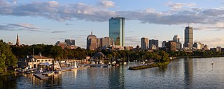
Back Bay is an officially recognized neighborhood of Boston, Massachusetts, built on reclaimed land in the Charles River basin. Construction began in 1859, as the demand for luxury housing exceeded the availability in the city at the time, and the area was fully built by around 1900. It is most famous for its rows of Victorian brownstone homes—considered one of the best preserved examples of 19th-century urban design in the United States—as well as numerous architecturally significant individual buildings, and cultural institutions such as the Boston Public Library, and Boston Architectural College. Initially conceived as a residential-only area, commercial buildings were permitted from around 1890, and Back Bay now features many office buildings, including the John Hancock Tower, Boston's tallest skyscraper. It is also considered a fashionable shopping destination and home to several major hotels.

Fieldston, Bronx Neighborhood of the Bronx in New York City

Fieldston is a privately owned affluent neighborhood in the Riverdale section of the northwestern part of the New York City borough of the Bronx. It is bounded by Manhattan College Parkway to the south, Henry Hudson Parkway to the west, 250th Street to the north, and Broadway to the east. It is noted for its rural atmosphere, large houses and abundance of trees. The majority of the neighborhood is included in the Fieldston Historic District, designated by the New York City Landmarks Preservation Commission in 2006.

Capitol Hill, Denver Neighborhood in Denver, Colorado, United States of America

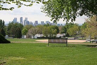
Located in the city and county of Denver, Colorado, the Capitol Hill neighborhood is bordered by Broadway, Downing Street, Colfax Avenue, and Seventh Avenue, which carry large volumes of traffic around the neighborhood. It is technically located in East Denver which begins immediately east of Broadway, the neighborhood's western boundary. Many consider the Cheesman Park neighborhood to be a part of the Capitol Hill neighborhood, but as defined by the city, Cheesman Park is a separate neighborhood. Denver also recognizes a statistical neighborhood called North Capitol Hill, also known as Uptown by some residents. Colfax Avenue is the border between these two neighborhoods.

Denver Civic Center Neighborhood in Denver, Colorado, USA

The Denver Civic Center is a civic center area that includes two parks surrounded by government and cultural buildings and spaces. Civic Center is located in central Denver, Colorado, on the south side of Downtown Denver. Much of the area is a historic district which was listed on the National Register of Historic Places in 1974. A somewhat smaller area was designated a U.S. National Historic Landmark in 2012 as one of the nation's finest examples of the City Beautiful movement of civic design. Denver Civic Center lies partially within the north end of an official Denver neighborhood also named Civic Center. It includes the Colorado State Capitol building, in the west end of Denver's official Capitol Hill neighborhood, and it includes a few buildings in the south end of Denver's Central Business District.

Civic Center, Denver (neighborhood) Human settlement in Denver, Colorado, United States of America

Civic Center, Denver is a neighborhood in Denver, Colorado, United States. The northern part of the neighborhood overlaps partially with the Denver Civic Center, an area of parks and civic buildings.

Saco Rienk DeBoer was born on September 7, 1883, in Ureterp, Opsterland, Friesland, Netherlands to architect Rienk Kornelius De Boer and avid gardener Antje Dictus Benedictus. He studied engineering and passed the Junior Engineer (surveyor) exam. He went on to study landscape architecture at The Royal Imperial School of Horticulture in Germany. He was diagnosed with tuberculosis, on the advice of doctors him to return home to Ureterp where he opened an office. His symptoms worsened in the summer of 1908, on doctor and family advice he emigrated to the United States in October 1908 be cured at the Dutch operated Bethesda Sanatarium in Maxwell, NM. In 1909 when Bethesda Sanitarium moved to Denver, he moved with it, planning the landscaping for the new building. He became the official Landscape Architect of Denver from 1910 to 1931. He also designed the planned community of Boulder City, Nevada. In 1919, he joined with another Dutchman, M. Walter Pesman, to form a partnership. Together their projects were many, among them the landscaping of both sides of Speer Boulevard in Denver, and two early and innovative Colorado subdivisions, Bonnie Brae in Denver and The Glens in Lakewood, both of which feature winding streets and multiple small "pocket parks."

Jefferson Park, Denver

Jefferson Park is a neighborhood and public park that overlooks Downtown Denver, Colorado from its perch across Interstate 25 (I-25). It is located in the area that is called North Denver. Views east from Jefferson Park take in Elitch Gardens Theme Park, The Children's Museum, Denver's Downtown Aquarium, Pepsi Center, the REI flagship store and other attractions in Downtown's Central Platte Valley. Downtown Denver and the Central Platte Valley are quickly accessed from Jefferson Park, using the 23rd Avenue overpass on I-25 and Water Street. In addition, the Light Rail C-Line is located by Empower Field at Mile High in the southern part of the neighborhood.

Lyon Village, Arlington, Virginia United States historic place

Lyon Village is a neighborhood, or "urban village" located in Arlington County, Virginia, along Lee Highway. It adjoins Arlington County's government center, and is approximately one mile west of Rosslyn and less than a mile north of Clarendon, of which it is sometimes considered a sub-neighborhood, as is Cherrydale, the mostly residential district immediately west of Lyon Village.

Lummus Park Historic District Neighborhood of Miami in Miami-Dade County, Florida, United States

The Lummus Park Historic District or simply Lummus Park, is on the National Register of Historic Places and a locally historic designated district in Miami, Florida. It is roughly bound by Northwest Fifth Street to the north, Flagler Street to the south, Northwest Third Avenue to the east, and the Miami River to the west. On October 25, 2006, it was added to the U.S. National Register of Historic Places. Lummus Park has some of the oldest structures in Miami, and over the decades, has been able to retain a large part of its early pioneer character.

Neighborhoods of Davenport, Iowa

The city of Davenport, Iowa, United States has neighborhoods dating back to the 1840s. The Davenport Plan and Zoning Commission divided the city into five areas: downtown, central, east end, near north, and northwest and west end. The neighborhoods contain many architectural designs, including Victorian, Queen Anne, and Tudor Revival. Many of the original neighborhoods were first inhabited by German settlers.

Chaffee Park, Denver Neighborhoods in Denver in Colorado, United States

Chaffee Park is a neighborhood in Denver, Colorado located in the northwest corner of the city. Chaffee Park is north of Sunnyside connected via Zuni Street, and northeast of Berkeley connected through Regis via nearby Lowell Boulevard. Chaffee Park is east of Regis and south of Adams County.

Speer is the official name for the Denver neighborhood bounded by 7th Avenue (north), Broadway (West), Alameda Avenue (South) and Downing Street (East). The northeast portion northeast of Speer Boulevard is generally referred to as Alamo Placita due to a local park and historic district of this name.

Amelia Stewart House Historic house in Alabama, United States

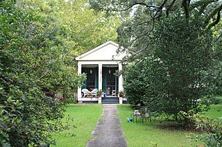
The Amelia Stewart House, also known as the Carol O. Wilkinson House and William Hallett House, is a historic residence in Mobile, Alabama, United States. It was built in 1835, with a significant Greek Revival style addition to the front built in 1871. The house was placed on the National Register of Historic Places on May 29, 1992, based on its architectural significance.

West Side Historic District (Saratoga Springs, New York) Historic district in New York, United States

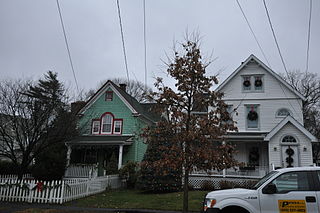
The West Side Historic District is a residential area of Saratoga Springs, New York, United States, located west of its downtown section. It is a 122-acre (49 ha) area extending from the blocks west of Broadway to extensions along Church and Washington streets. The former Franklin Square Historic District is included in its entirety.

Fourth Ward Historic District (Greenwich, Connecticut) Historic district in Connecticut, United States

The Fourth Ward Historic District encompasses an early urban residential subdivision of Greenwich, Connecticut. Extending north from United States Route 1 along Sherwood Place, Church Street, and adjacent streets, it is one of two subdivisions created before the arrival of the railroad in Greenwich in 1848. It is characterized by dense residential construction, with architectural styles from the Greek Revival to early 20th-century styles. The district was listed on the National Register of Historic Places in 2000.

Alamo Placita Park United States historic place

Alamo Placita Park is a city park located in Denver, Colorado that is the namesake of the Alamo Placita, Denver neighborhood.

Riverview Park Plat Historic District Historic district in Iowa, United States

The Riverview Park Plat Historic District is located in the north-central section of Des Moines, Iowa, United States. It has been listed on the National Register of Historic Places since 1996.

Aurora Highlands Historic District Historic district in Virginia, United States

The Aurora Highlands Historic District is a national historic district located at Arlington County, Virginia. It contains 624 contributing buildings, 2 contributing sites, and 1 contributing structure in a residential neighborhood in South Arlington. Aurora Highlands was formed by the integration of three subdivisions platted between 1896 and 1930, with improvements in the form of modest single-family residences. The district is characterized by single family dwellings with a number of twin dwellings and duplexes, three churches, a rectory, two schools, two landscaped parks, and commercial buildings. The oldest dwelling is associated with “Sunnydale Farm” and is a Greek Revival-style dwelling built about 1870. The predominant architectural style represented is Colonial Revival.

The Humboldt Avenue Historic District is a historic district encompassing a cluster of multifamily brick buildings in the Dorchester neighborhood of Boston, Massachusetts. Centered on the junction of Humboldt Avenue and Hutchings Street, the area was developed in 1915-16 during a major Jewish migration, and includes a fine sample of Colonial Revival architecture. The district was listed on the National Register of Historic Places in 2021.

References

Alamo Placita Neighbors Association (APNA), APNA April 2009 Newsletter, Joe Halpern

  1. "Home". alamoplacita.org.

Coordinates: 39°43′15″N104°58′33″W / 39.72083°N 104.97583°W / 39.72083; -104.97583