Alberta, Minnesota

Last updated

Alberta, Minnesota
Stevens County Minnesota Incorporated and Unincorporated areas Alberta Highlighted.svg
Location of Alberta, Minnesota
Coordinates: 45°34′30″N96°03′02″W / 45.57500°N 96.05056°W / 45.57500; -96.05056
CountryUnited States
State Minnesota
County Stevens
Incorporated May 6, 1912
Government
   Mayor Roger D. Gausman
Area
[1]
  Total0.263 sq mi (0.680 km2)
  Land0.263 sq mi (0.680 km2)
  Water0.000 sq mi (0.000 km2)
Elevation
[2]
1,109 ft (338 m)
Population
 (2020) [3]
  Total94
  Estimate 
(2022) [4]
93
  Density357.41/sq mi (138.18/km2)
Time zone UTC–6 (Central (CST))
  Summer (DST) UTC–5 (CDT)
ZIP Code
56207
Area code 320
FIPS code 27-00676
GNIS feature ID2393903 [2]
Sales tax 6.875% [5]

Alberta is a city in Stevens County, Minnesota, United States. The population was 94 at the 2020 census. [3]

Contents

History

A post office called Alberta has been in operation since 1896. [6] The city was named for Alberta Lindsey, the wife of an early settler. [7] The city contains one property listed on the National Register of Historic Places, the 1917 Alberta Teachers House. [8]

Geography

According to the United States Census Bureau, the city has a total area of 0.263 square miles (0.68 km2), all land. [1]

Minnesota State Highway 28 serves as a main route in the community.

Demographics

Historical population
CensusPop.Note
1920 109
1930 15340.4%
1940 20030.7%
1950 139−30.5%
1960 1497.2%
1970 140−6.0%
1980 1453.6%
1990 136−6.2%
2000 1424.4%
2010 103−27.5%
2020 94−8.7%
2022 (est.)93 [4] −1.1%
U.S. Decennial Census [9]
2020 Census [3]

2010 census

As of the 2010 census, there were 103 people, 41 households, and 32 families residing in the city. The population density was 381.5 inhabitants per square mile (147.3/km2). There were 51 housing units at an average density of 188.9 per square mile (72.9/km2). The racial makeup of the city was 100.0% White.

There were 41 households, of which 22.0% had children under the age of 18 living with them, 63.4% were married couples living together, 7.3% had a female householder with no husband present, 7.3% had a male householder with no wife present, and 22.0% were non-families. 19.5% of all households were made up of individuals, and 9.8% had someone living alone who was 65 years of age or older. The average household size was 2.51, and the average family size was 2.84.

The median age in the city was 46.5 years. 22.3% of residents were under the age of 18, 3.9% were between the ages of 18 and 24, 23.3% were from 25 to 44, 34.9% were from 45 to 64, and 15.5% were 65 years of age or older. The gender makeup of the city was 53.4% male and 46.6% female.

2000 census

As of the 2000 census, there were 142 people, 52 households, and 42 families residing in the city. The population density was 513.2 inhabitants per square mile (198.1/km2). There were 56 housing units at an average density of 202.4 per square mile (78.1/km2). The racial makeup of the city was 100.00% White.

There were 52 households, out of which 40.4% had children under the age of 18 living with them, 65.4% were married couples living together, 7.7% had a female householder with no husband present, and 19.2% were non-families. 19.2% of all households were made up of individuals, and 5.8% had someone living alone who was 65 years of age or older. The average household size was 2.73 and the average family size was 3.10.

In the city, the population was spread out, with 31.7% under the age of 18, 4.9% from 18 to 24, 30.3% from 25 to 44, 21.1% from 45 to 64, and 12.0% who were 65 years of age or older. The median age was 34 years. For every 100 females, there were 100.0 males. For every 100 females age 18 and over, there were 98.0 males.

The median income for a household in the city was $43,500, and the median income for a family was $44,000. Males had a median income of $29,250 versus $20,250 for females. The per capita income for the city was $15,296. None of the population and none of the families were below the poverty line.

Related Research Articles

<span class="mw-page-title-main">Odessa, Minnesota</span> City in Minnesota, United States

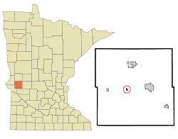
Odessa is a city in Big Stone County, Minnesota, United States. The population was 103 at the 2020 census.

<span class="mw-page-title-main">Emily, Minnesota</span> City in Minnesota, United States

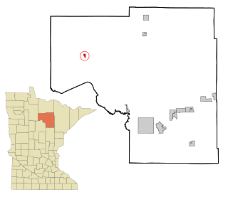
Emily is a city in Crow Wing County, Minnesota, United States. The population was 843 at the 2020 census. It is part of the Brainerd Micropolitan Statistical Area.

<span class="mw-page-title-main">Trommald, Minnesota</span> City in Minnesota, United States

Trommald is a city in Crow Wing County, Minnesota, United States. The population was 99 at the 2020 census. It is part of the Brainerd Micropolitan Statistical Area.

<span class="mw-page-title-main">Twin Lakes, Freeborn County, Minnesota</span> City in Minnesota, United States

Twin Lakes is a city in Freeborn County, Minnesota, United States, near Albert Lea. The population was 134 at the 2020 census.

<span class="mw-page-title-main">Keewatin, Minnesota</span> City in Minnesota, United States

Keewatin is a city in Itasca County, Minnesota, United States. The population was 984 at the 2020 census.

<span class="mw-page-title-main">Squaw Lake, Minnesota</span> City in Minnesota, United States

Squaw Lake is a city in Itasca County, Minnesota, United States. The population was 98 at the 2020 census.

<span class="mw-page-title-main">Sunburg, Minnesota</span> City in Minnesota, United States

Sunburg is a city in Kandiyohi County, Minnesota, United States. The population was 94 at the 2020 census.

<span class="mw-page-title-main">Viking, Minnesota</span> City in Minnesota, United States

Viking is a city in Marshall County, Minnesota, United States. The population was 79 at the 2020 census.

<span class="mw-page-title-main">Harding, Minnesota</span> City in Minnesota, United States

Harding is a city in Morrison County, Minnesota, United States. The population was 123 at the 2020 census.

<span class="mw-page-title-main">Hillman, Minnesota</span> City in Minnesota, United States

Hillman is a city in Morrison County, Minnesota, United States. The population was 23 at the 2020 census.

<span class="mw-page-title-main">Erhard, Minnesota</span> City in Minnesota, United States

Erhard is a city in Otter Tail County, Minnesota, United States. The population was 132 at the 2020 census.

<span class="mw-page-title-main">Urbank, Minnesota</span> City in Minnesota, United States

Urbank is a city in Otter Tail County, Minnesota, United States. The population was 52 at the 2020 census.

<span class="mw-page-title-main">Gully, Minnesota</span> City in Minnesota, United States

Gully is a city in Polk County, Minnesota, United States. It is part of the Grand Forks-ND-MN Metropolitan Statistical Area. The population was 59 at the 2020 census.

<span class="mw-page-title-main">Mentor, Minnesota</span> City in Minnesota, United States

Mentor is a city in Polk County, Minnesota, United States. It is part of the Grand Forks-ND-MN Metropolitan Statistical Area. The population was 104 at the 2020 census. The city is near Maple Lake.

<span class="mw-page-title-main">Nielsville, Minnesota</span> City in Minnesota, United States

Nielsville is a city in Polk County, Minnesota, United States. It is part of the Grand Forks, ND-MN Metropolitan Statistical Area. The population was 78 at the 2020 census.

<span class="mw-page-title-main">Trail, Minnesota</span> City in Minnesota, United States

Trail is a city in Polk County, Minnesota, United States. It is part of the Grand Forks, ND-MN Metropolitan Statistical Area. The population was 40 at the 2020 census.

<span class="mw-page-title-main">McKinley, St. Louis County, Minnesota</span> City in Minnesota, United States

McKinley is a city in Saint Louis County, Minnesota, United States; located within the Iron Range region of Minnesota. The population was 103 at the 2020 census.

<span class="mw-page-title-main">St. Rosa, Minnesota</span> City in Minnesota, United States

Saint Rosa is a city in Stearns County, Minnesota, United States. The population was 58 at the 2020 census. It is part of the St. Cloud Metropolitan Statistical Area.

<span class="mw-page-title-main">St. Leo, Minnesota</span> City in Minnesota, United States

St. Leo or Saint Leo is a city in Yellow Medicine County, Minnesota, United States. The population was 93 at the 2020 census.

<span class="mw-page-title-main">Minneiska, Minnesota</span> City in Minnesota, United States

Minneiska is a city in Wabasha and Winona counties in the U.S. state of Minnesota. The population was 97 at the 2020 census.

References

  1. 1 2 "2023 U.S. Gazetteer Files". United States Census Bureau. Retrieved February 28, 2024.
  2. 1 2 U.S. Geological Survey Geographic Names Information System: Alberta, Minnesota
  3. 1 2 3 "Explore Census Data". United States Census Bureau . Retrieved February 28, 2024.
  4. 1 2 "City and Town Population Totals: 2020–2022". United States Census Bureau. February 28, 2024. Retrieved February 28, 2024.
  5. "Alberta (MN) sales tax rate" . Retrieved February 28, 2024.
  6. "Stevens County". Jim Forte Postal History. Retrieved August 1, 2015.
  7. Upham, Warren (1920). Minnesota Geographic Names: Their Origin and Historic Significance. Minnesota Historical Society. p.  535.
  8. "Minnesota National Register Properties Database". Minnesota Historical Society. 2009. Retrieved March 11, 2018.
  9. "Census of Population and Housing". United States Census Bureau. Retrieved June 4, 2015.