Donnelly, Minnesota

Last updated

Donnelly
Stevens County Minnesota Incorporated and Unincorporated areas Donnelly Highlighted.svg
Location of Donnelly, Minnesota
Coordinates: 45°41′23″N96°00′51″W / 45.68972°N 96.01417°W / 45.68972; -96.01417
CountryUnited States
State Minnesota
County Stevens
Area
[1]
  Total3.11 sq mi (8.05 km2)
  Land2.78 sq mi (7.21 km2)
  Water0.32 sq mi (0.84 km2)
Elevation
[2]
1,129 ft (344 m)
Population
 (2020) [3]
  Total221
  Estimate 
(2021) [4]
216
  Density79.38/sq mi (30.65/km2)
Time zone UTC-6 (CST)
  Summer (DST) UTC-5 (CDT)
ZIP code
56235
Area code 320
FIPS code 27-16084 [5]
GNIS feature ID2394546 [2]

Donnelly is a city in Stevens County, Minnesota, United States. The population was 221 at the 2020 census. [3]

Contents

History

Donnelly was originally called Douglas, and under the latter name was laid out in 1872. [6] The present name is in honor of Ignatius L. Donnelly, a U.S. Congressman from Minnesota. [6] A post office called Donnelly has been in operation since 1876. [7]

The annual Donnelly Threshing Bee was first held in 1965. [8]

Geography

According to the United States Census Bureau, the city has a total area of 3.08 square miles (7.98 km2), of which 2.76 square miles (7.15 km2) is land and 0.32 square miles (0.83 km2) is water. [9]

Minnesota State Highway 9 serves as a main route in the community.

Demographics

Historical population
CensusPop.Note
1900 164
1910 27668.3%
1920 35428.3%
1930 309−12.7%
1940 37019.7%
1950 3967.0%
1960 358−9.6%
1970 252−29.6%
1980 31725.8%
1990 221−30.3%
2000 25414.9%
2010 241−5.1%
2020 221−8.3%
2021 (est.)216 [4] −2.3%
U.S. Decennial Census [10]
2020 Census [3]

2010 census

As of the census of 2010, there were 241 people, 113 households, and 72 families residing in the city. The population density was 87.3 inhabitants per square mile (33.7/km2). There were 125 housing units at an average density of 45.3 per square mile (17.5/km2). The racial makeup of the city was 100.0% White.

There were 113 households, of which 22.1% had children under the age of 18 living with them, 52.2% were married couples living together, 7.1% had a female householder with no husband present, 4.4% had a male householder with no wife present, and 36.3% were non-families. 28.3% of all households were made up of individuals, and 17.7% had someone living alone who was 65 years of age or older. The average household size was 2.13 and the average family size was 2.63.

The median age in the city was 50.1 years. 17.8% of residents were under the age of 18; 4.1% were between the ages of 18 and 24; 20.7% were from 25 to 44; 27.5% were from 45 to 64; and 29.9% were 65 years of age or older. The gender makeup of the city was 49.4% male and 50.6% female.

2000 census

As of the census of 2000, there were 254 people, 114 households, and 71 families residing in the city. The population density was 92.2 inhabitants per square mile (35.6/km2). There were 121 housing units at an average density of 43.9 per square mile (16.9/km2). The racial makeup of the city was 98.03% White, 0.79% Native American, 1.18% from other races. Hispanic or Latino of any race were 1.18% of the population.

There were 114 households, out of which 27.2% had children under the age of 18 living with them, 57.9% were married couples living together, 1.8% had a female householder with no husband present, and 37.7% were non-families. 31.6% of all households were made up of individuals, and 15.8% had someone living alone who was 65 years of age or older. The average household size was 2.23 and the average family size was 2.82.

In the city, the population was spread out, with 24.0% under the age of 18, 5.1% from 18 to 24, 28.7% from 25 to 44, 20.1% from 45 to 64, and 22.0% who were 65 years of age or older. The median age was 41 years. For every 100 females, there were 96.9 males. For every 100 females age 18 and over, there were 99.0 males.

The median income for a household in the city was $35,972, and the median income for a family was $41,250. Males had a median income of $33,125 versus $13,750 for females. The per capita income for the city was $22,523. About 2.7% of families and 2.5% of the population were below the poverty line, including none of those under the age of eighteen and 11.8% of those 65 or over.

Related Research Articles

<span class="mw-page-title-main">Backus, Minnesota</span> City in Minnesota, United States

Backus is a city in Cass County, Minnesota, United States. The population was 250 at the 2010 census. It is part of the Brainerd Micropolitan Statistical Area.

<span class="mw-page-title-main">Chickamaw Beach, Minnesota</span> City in Minnesota, United States

Chickamaw Beach is a city in Cass County, Minnesota, United States. The population was 114 at the 2010 census. It is part of the Brainerd Micropolitan Statistical Area.

<span class="mw-page-title-main">Lake Shore, Minnesota</span> City in Minnesota, United States

Lake Shore is a city in Cass County, Minnesota, United States. The population was 1,056 at the 2020 census. It is part of the Brainerd Micropolitan Statistical Area.

<span class="mw-page-title-main">Crosby, Minnesota</span> City in Minnesota, United States

Crosby is a city in Crow Wing County, Minnesota, United States. The population was 2,386 at the 2010 census. It is part of the Brainerd Micropolitan Statistical Area. Crosby is adjacent to its twin city of Ironton, in the Cuyuna iron range.

<span class="mw-page-title-main">Ironton, Minnesota</span> City in Minnesota, United States

Ironton is a city in Crow Wing County, Minnesota, United States. The population was 572 at the 2010 census. It is part of the Brainerd Micropolitan Statistical Area.

<span class="mw-page-title-main">Isanti, Minnesota</span> City in the United States

Isanti is a city in Isanti County, Minnesota, United States. The population was 6,804 at the 2020 census. The name Isanti is composed of two Dakota words: isan ("knife") and ati ("camp"), and refers to the Santee Dakota people.

Donnelly Township is a township in Marshall County, Minnesota, United States. The population was 28 at the 2000 census.

<span class="mw-page-title-main">Lastrup, Minnesota</span> City in Minnesota, United States

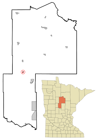
Lastrup is a city in Morrison County, Minnesota, United States. The population was 120 at the 2020 census.

<span class="mw-page-title-main">Clitherall, Minnesota</span> City in Minnesota, United States

Clitherall is a city in Otter Tail County, Minnesota, United States. The population was 62 at the 2020 census.

<span class="mw-page-title-main">Elizabeth, Minnesota</span> City in Minnesota, United States

Elizabeth is a city in Otter Tail County, Minnesota, United States. The population was 168 at the 2020 census.

<span class="mw-page-title-main">Erhard, Minnesota</span> City in Minnesota, United States

Erhard is a city in Otter Tail County, Minnesota, United States. The population was 132 at the 2020 census.

<span class="mw-page-title-main">Henning, Minnesota</span> City in Minnesota, United States

Henning is a city in Otter Tail County, Minnesota, United States. The population was 854 at the 2020 census.

<span class="mw-page-title-main">Richville, Minnesota</span> City in Minnesota, United States

Richville is a city in Otter Tail County, Minnesota, United States. The population was 77 as of the 2020 census.

<span class="mw-page-title-main">Urbank, Minnesota</span> City in Minnesota, United States

Urbank is a city in Otter Tail County, Minnesota, United States. The population was 52 at the 2020 census.

<span class="mw-page-title-main">Olivia, Minnesota</span> City in Minnesota, United States

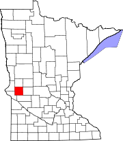
Olivia is the county seat of Renville County, Minnesota, United States. Its population was 2,484 at the 2010 census.

<span class="mw-page-title-main">McKinley, St. Louis County, Minnesota</span> City in Minnesota, United States

McKinley is a city in Saint Louis County, Minnesota, United States; located within the Iron Range region of Minnesota. The population was 103 at the 2020 census.

Donnelly Township is a township in Stevens County, Minnesota, United States. The population was 113 at the 2000 census.

<span class="mw-page-title-main">Dellwood, Minnesota</span> City in Minnesota, United States

Dellwood is a city in Washington County, Minnesota, United States and a suburb of St. Paul. The population was 1,063 at the 2010 census.

<span class="mw-page-title-main">Minnesota City, Minnesota</span> City in Minnesota, United States

Minnesota City is a city in Winona County, Minnesota, United States. The population was 202 at the 2020 census.

<span class="mw-page-title-main">Dennison, Minnesota</span> City in Minnesota, United States

Dennison is a city in Goodhue and Rice counties in the U.S. state of Minnesota. The population was 212 at the 2010 census. Most of Dennison is in Goodhue County, with only a small part that extends into Rice County.

References

  1. "2020 U.S. Gazetteer Files". United States Census Bureau. Retrieved July 24, 2022.
  2. 1 2 U.S. Geological Survey Geographic Names Information System: Donnelly, Minnesota
  3. 1 2 3 "Explore Census Data". United States Census Bureau . Retrieved May 10, 2022.
  4. 1 2 "City and Town Population Totals: 2020-2021". United States Census Bureau. July 4, 2022. Retrieved July 4, 2022.
  5. "American FactFinder". United States Census Bureau. Archived from the original on February 12, 2020. Retrieved January 31, 2008.
  6. 1 2 Upham, Warren (1920). Minnesota Geographic Names: Their Origin and Historic Significance. Minnesota Historical Society. p.  536.
  7. "Stevens County". Jim Forte Postal History. Retrieved August 1, 2015.
  8. "History of the Donnelly Threshing Bee". donnellythreshingbee.com. Retrieved September 7, 2020.
  9. "US Gazetteer files 2010". United States Census Bureau. Archived from the original on July 2, 2012. Retrieved November 13, 2012.
  10. "Census of Population and Housing". Census.gov. Archived from the original on April 26, 2015. Retrieved June 4, 2015.

http://www.morrissuntribune.com/tags/donnelly Archived March 4, 2016, at the Wayback Machine http://www.morrissuntribune.com/content/write-candidates-offer-unpredictable-results-local-races-stevens-county Archived March 4, 2016, at the Wayback Machine