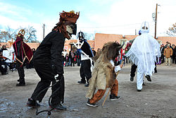
Alcalde, New Mexico | |
---|---|
Coordinates: 36°5′17″N106°3′25″W / 36.08806°N 106.05694°W | |
Country | United States |
State | New Mexico |
County | Rio Arriba |
Area | |
• Total | 0.52 sq mi (1.34 km2) |
• Land | 0.52 sq mi (1.34 km2) |
• Water | 0.00 sq mi (0.00 km2) |
Elevation | 5,712 ft (1,741 m) |
Population | |
• Total | 310 |
• Density | 600.78/sq mi (231.90/km2) |
Time zone | UTC-7 (Mountain (MST)) |
• Summer (DST) | UTC-6 (MDT) |
ZIP code | 87511 |
Area code | 505 |
FIPS code | 35-02070 |
GNIS feature ID | 0928680 |
Alcalde (Spanish for mayor) is a census-designated place (CDP) in Rio Arriba County, New Mexico, United States. The population was 285 at the 2010 census. [3]
According to the United States Census Bureau, the CDP has a total area of 0.5 square miles (1.3 km2), all land. [3]
Climate data for Alcalde, New Mexico, 1991–2020 normals, extremes 1953–present | |||||||||||||
---|---|---|---|---|---|---|---|---|---|---|---|---|---|
Month | Jan | Feb | Mar | Apr | May | Jun | Jul | Aug | Sep | Oct | Nov | Dec | Year |
Record high °F (°C) | 70 (21) | 73 (23) | 83 (28) | 88 (31) | 98 (37) | 101 (38) | 102 (39) | 100 (38) | 95 (35) | 90 (32) | 79 (26) | 68 (20) | 102 (39) |
Mean maximum °F (°C) | 58.1 (14.5) | 64.7 (18.2) | 74.7 (23.7) | 80.9 (27.2) | 88.4 (31.3) | 95.6 (35.3) | 96.6 (35.9) | 93.6 (34.2) | 89.5 (31.9) | 81.7 (27.6) | 69.3 (20.7) | 58.4 (14.7) | 97.5 (36.4) |
Mean daily maximum °F (°C) | 45.1 (7.3) | 51.0 (10.6) | 60.0 (15.6) | 67.4 (19.7) | 76.2 (24.6) | 86.0 (30.0) | 88.1 (31.2) | 85.6 (29.8) | 79.8 (26.6) | 68.7 (20.4) | 55.4 (13.0) | 44.5 (6.9) | 67.3 (19.6) |
Daily mean °F (°C) | 30.2 (−1.0) | 35.3 (1.8) | 42.4 (5.8) | 49.6 (9.8) | 58.1 (14.5) | 67.1 (19.5) | 71.8 (22.1) | 69.6 (20.9) | 62.2 (16.8) | 50.3 (10.2) | 38.7 (3.7) | 29.8 (−1.2) | 50.4 (10.2) |
Mean daily minimum °F (°C) | 15.3 (−9.3) | 19.6 (−6.9) | 24.8 (−4.0) | 31.9 (−0.1) | 39.9 (4.4) | 48.2 (9.0) | 55.4 (13.0) | 53.7 (12.1) | 44.6 (7.0) | 31.9 (−0.1) | 22.0 (−5.6) | 15.2 (−9.3) | 33.5 (0.8) |
Mean minimum °F (°C) | 4.5 (−15.3) | 8.5 (−13.1) | 13.8 (−10.1) | 20.9 (−6.2) | 29.0 (−1.7) | 38.5 (3.6) | 46.5 (8.1) | 45.9 (7.7) | 33.5 (0.8) | 21.5 (−5.8) | 11.0 (−11.7) | 5.0 (−15.0) | 1.4 (−17.0) |
Record low °F (°C) | −34 (−37) | −12 (−24) | 4 (−16) | 11 (−12) | 18 (−8) | 32 (0) | 39 (4) | 34 (1) | 23 (−5) | 9 (−13) | −11 (−24) | −11 (−24) | −34 (−37) |
Average precipitation inches (mm) | 0.51 (13) | 0.39 (9.9) | 0.69 (18) | 0.70 (18) | 0.78 (20) | 0.78 (20) | 1.65 (42) | 1.75 (44) | 1.25 (32) | 1.14 (29) | 0.73 (19) | 0.73 (19) | 11.10 (282) |
Average snowfall inches (cm) | 2.2 (5.6) | 1.5 (3.8) | 1.4 (3.6) | 0.3 (0.76) | 0.0 (0.0) | 0.0 (0.0) | 0.0 (0.0) | 0.0 (0.0) | 0.0 (0.0) | 0.6 (1.5) | 1.4 (3.6) | 3.3 (8.4) | 10.7 (27.26) |
Average precipitation days (≥ 0.01 in) | 2.8 | 3.0 | 3.8 | 4.1 | 4.2 | 3.9 | 8.2 | 8.5 | 5.4 | 4.9 | 3.1 | 3.3 | 55.2 |
Average snowy days (≥ 0.1 in) | 1.3 | 1.1 | 0.5 | 0.3 | 0.0 | 0.0 | 0.0 | 0.0 | 0.0 | 0.2 | 0.5 | 1.7 | 5.6 |
Source 1: NOAA [4] | |||||||||||||
Source 2: National Weather Service [5] |
Census | Pop. | Note | %± |
---|---|---|---|
2020 | 310 | — | |
U.S. Decennial Census [6] [2] |
At the 2000 census there were 377 people, 121 households, and 99 families in the CDP. The population density was 735.3 inhabitants per square mile (283.9/km2). There were 138 housing units at an average density of 269.2 per square mile (103.9/km2). The racial makeup of the CDP was 37.40% White, 0.27% African American, 1.59% Native American, 0.27% Asian, 54.64% from other races, and 5.84% from two or more races. Hispanic or Latino of any race were 89.12%. [7]
Of the 121 households 46.3% had children under the age of 18 living with them, 52.1% were married couples living together, 19.8% had a female householder with no husband present, and 17.4% were non-families. 16.5% of households were one person and 7.4% were one person aged 65 or older. The average household size was 3.12 and the average family size was 3.39.
The age distribution was 32.9% under the age of 18, 7.2% from 18 to 24, 32.1% from 25 to 44, 15.4% from 45 to 64, and 12.5% 65 or older. The median age was 31 years. For every 100 females, there were 95.3 males. For every 100 females age 18 and over, there were 99.2 males.
The median household income was $37,969 and the median family income was $38,250. Males had a median income of $31,375 versus $20,341 for females. The per capita income for the CDP was $13,656. About 10.7% of families and 12.6% of the population were below the poverty line, including 8.6% of those under age 18 and 13.6% of those age 65 or over.
It is in Española Public Schools. [8] Alcalde has one elementary school, Alcalde Elementary. The comprehensive public high school is Española Valley High School.
The Oñate Monument Center located in Alcalde on New Mexico Highway 68.
Rio Arriba County is a county in the U.S. state of New Mexico. As of the 2020 census, the population was 40,363. Its county seat is Tierra Amarilla. Its northern border is the Colorado state line.
Chilili is a census-designated place in Bernalillo County, New Mexico, United States. The population was 137 at the 2010 census. It is part of the Albuquerque Metropolitan Statistical Area.
Brimhall Nizhoni is a census-designated place (CDP) in McKinley County, New Mexico, United States. The population was 199 at the 2010 census. The Navajo Coyote Canyon Chapter House is located in Brimhall.
Dulce is a census-designated place (CDP) in Rio Arriba County, New Mexico, United States. The population was 2,743 at the 2010 census, almost entirely Native American. It is the largest community and tribal headquarters of the Jicarilla Apache Reservation.
San Juan is a census-designated place (CDP) in Rio Arriba County, New Mexico, United States. The population was 592 at the 2000 census.
Flora Vista is a census-designated place (CDP) in San Juan County, New Mexico, United States. The population was 1,383 at the 2000 census. It is part of the Farmington Metropolitan Statistical Area. Flora Vista was founded in 1877 by settlers from Colorado who built cabins along the Animas River. A post office was established the following year. The name derived from the view of wildflowers in the valley.
Naschitti is a census-designated place (CDP) in San Juan County, New Mexico, United States. The population was 360 at the 2000 census. It is part of the Farmington Metropolitan Statistical Area. The town was established in 1886, when Tom Bryan set up a trading post east of the Chuska Mountains. With a Navajo name, Naschitti means "badger springs."
Ponderosa is a census-designated place (CDP) in Sandoval County, New Mexico, United States. The population was 383 as of New Mexico's 2015 Census. It is part of the Albuquerque Metropolitan Statistical Area.
Pueblo of Sandia Village is a census-designated place (CDP) in Sandoval County, New Mexico, United States. The population was 344 at the 2000 census. It is part of the Albuquerque Metropolitan Statistical Area.
Zia Pueblo is a census-designated place (CDP) in Sandoval County, New Mexico, United States. The population was 646 at the 2000 census, with 310 males and 336 females. The pueblo after which the CDP is named is included within the CDP; it is listed on the National Register of Historic Places.
Cañada de los Alamos is a census-designated place (CDP) in Santa Fe County, New Mexico, United States. It is part of the Santa Fe, New Mexico Metropolitan Statistical Area. The population was 434 at the 2010 census.
Cedar Grove is a census-designated place (CDP) in Santa Fe County, New Mexico, United States. It is part of the Santa Fe, New Mexico Metropolitan Statistical Area. The population was 747 at the 2010 census. Cedar Grove was formerly a stage and freight stop. It has developed into a Santa Fe suburb. New Mexico "cedars" are abundant in the town.
Chupadero is a census-designated place (CDP) in Santa Fe County, New Mexico, United States. It is part of the Santa Fe, New Mexico Metropolitan Statistical Area. The population was 362 at the 2010 census.
Cundiyo is a census-designated place (CDP) in Santa Fe County, New Mexico, United States. It is part of the Santa Fe, New Mexico Metropolitan Statistical Area. The population was 72 at the 2010 census. The name means round hill of the little bells in Tewa.
El Valle de Arroyo Seco is a census-designated place (CDP) in Santa Fe County, New Mexico, United States. It is part of the Santa Fe, New Mexico Metropolitan Statistical Area. The population was 1,440 at the 2010 census.
La Puebla is a census-designated place (CDP) in Santa Fe County, New Mexico, United States. It is part of the Santa Fe, New Mexico Metropolitan Statistical Area. The population was 1,296 at the 2000 census.
Rio Chiquito is a census-designated place in Santa Fe County, New Mexico, United States. It is part of the Santa Fe, New Mexico Metropolitan Statistical Area. The population was 103 at the 2000 census.
Sombrillo is a census-designated place (CDP) in Santa Fe County, New Mexico, United States. It is part of the Santa Fe, New Mexico Metropolitan Statistical Area. The population was 493 according to the 2000 census.
Peralta is a town in Valencia County, New Mexico, United States. Prior to its incorporation on July 1, 2007, it was a census-designated place (CDP). The population was 3,660 as of the 2010 census. Peralta is part of the Albuquerque metropolitan area.
Velarde is a census-designated place (CDP) in Rio Arriba County, New Mexico, United States. The population was 502 at the time of the 2010 census. Velarde is located on New Mexico State Road 68, in the Rio Grande Rift, at the point where the road enters the Rio Grande Gorge.