Alexandra, Victoria

Last updated

Alexandra
Victoria
Alexandra Victoria Grant Street.jpg
Grant Street
Australia Victoria Murrindindi Shire location map.svg
Red pog.svg
Alexandra
Location in Shire of Murrindindi
Coordinates 37°11′30″S145°42′35″E / 37.19167°S 145.70972°E / -37.19167; 145.70972
Population2,695 (2016 census) [1]
Postcode(s) 3714
Elevation221 m (725 ft)
Location
LGA(s) Shire of Murrindindi
State electorate(s) Eildon
Federal division(s) Indi
Mean max tempMean min tempAnnual rainfall
20.6 °C
69 °F
6.6 °C
44 °F
714.2 mm
28.1 in

Alexandra is a town in north-east Victoria, Australia, 130 kilometres north-east of the State Capital, Melbourne. It is located at the junction of the Goulburn Valley Highway (B340) and Maroondah Highway (B360), in the Shire of Murrindindi local government area. At the 2016 census, the town had a population of 2,695 and the broader area (Alexandra District) a population of 6420. [1]

Contents

Gold mining was the catalyst for the development of the town with many mines around Alexandra and particularly along Ultima Thule Creek, known locally as UT Creek, which runs through the town. The town's post office was opened in 1867.

The town has a number of parks. Rotary Park is adjacent to UT Creek and the town's main street and includes toilets, barbecues and the Visitor Information Centre. Leckie Park is a larger, picturesque park of over 11 hectares, also along UT Creek. It includes the Alexandra Bowling Club, a playground and the town's cenotaph.

Lake Eildon, a major water storage, is 12 kilometres east of Alexandra and a major tourist attraction for boating and fishing. The nearby Goulburn River and other local streams such as the Rubicon River also attract many anglers. The Riversdale bridge across the Goulburn is only about 2 kilometres west of the town centre. Other popular activities in the area include hunting, four wheel driving, hiking and camping.

Alexandra is the largest town in this part of Victoria and the headquarters of the Shire of Murrindindi as well as State government departments.

History

The original inhabitants of the area were members of two clans of the Taungurung aboriginal people. [2]

The town was settled by Europeans in the late 1860s, with a Post Office opening on 15 March 1867 (known until 24 April 1867) as Redgate. [3] The town was originally known as Redgate, or Red Gate Diggings. [4] The current name is thought to derive from either Alexandra of Denmark, when the shire was given a statue of her, or from three men named Alexander (Alesander McGregor, Alexander Don, and Alexander Luckie) who discovered gold in the area in 1866. [4] Alexandra has a rich history encompassing gold mining, farming and timber. Industry and commerce has developed along with many other pursuits over a broad spectrum.

Alexandra, at the gateway to the high country & the snow, has played a big part in the development of Victoria's high country, mountain cattle grazing and particularly the timber industry that has resulted in Victoria being able to develop. Alexandra was home to a number of large timber mills, especially during the mid to late 20th century.

Farming has always been an important component of the local economy. This has diversified over the years with beef production continuing, still some sheep farming, but other activities also important including wineries, fruit growing, fish production & other pursuits including major commercial lawn growing.

Electricity production from the nearby hydro stations at Rubicon and Eildon has been an important part of the local economy since the 1920s and employed many from Alexandra and district. The Rubicon 'A' switching facility has also been important for power generation in Victoria together with its maintenance workforce. Since the State Electricity Commission was privatised during the 1990s some changes in operations have reduced the local workforce and more automated equipment is being utilised.

Tourism is fundamental to the Alexandra District and continues to attract many, for obvious reasons.

The railway to Alexandra arrived as a branch line of the Mansfield railway line in 1909, and closed on 18 November 1978. [5] In 2012, the closed rail line was developed as part of the route for the 134 km long Great Victorian Rail Trail.

The Rubicon Tramway connected Alexandra with the village of Rubicon (locally often known as 'The Tin Hut'), at the junction of the Rubicon and Royston Rivers. [6]

The Alexandra Magistrates' Court closed on 1 January 1990. [7]

The Black Saturday bushfires that burnt across much of Murrindindi Shire on, and following, 7 February 2009 impacted the area heavily. Alexandra provided support and shelter for many hundreds of people affected by the fires. The fire was managed from the Alexandra Incident Control Centre at the Department of Environment, Land & Planning (DELWP) Offices. Local DELWP and CFA firefighters were heavily involved in controlling the fires over many weeks and the town's service clubs, emergency services, agencies and community volunteers and townspeople provided immediate and long term assistance. Large numbers of firefighting resources, which were brought in to the town, were temporarily housed at a staging area at the Alexandra Showgrounds and at the rear of the Emergency Services Facility in Shamrock Street as well as other locations for many weeks during the firefighting operations.

Alexandra was untouched directly by the fires but was under considerable threat for some time, on occasions, with the fire fronts being only about 9 kilometres distant for periods.

Major fires have impacted Alexandra over the years with 1939 and 1969 also being especially disastrous for the area.

Alexandra today

Many tourists pass through this town on their way to Mount Buller ski resort from Melbourne and Lake Eildon. Fraser Camping Area bordering Lake Eildon within Lake Eildon National Park attracts many visitors to the area.

To the south of Alexandra, Lake Mountain Alpine Resort, near Marysville, also attracts many day trippers to the mountain, especially during the winter snow.

Cathedral Range State Park, near Taggerty, south of Alexandra is also a popular location for hiking and camping.

The Great Victorian Rail Trail branches to Alexandra and is popular.

The town of Alexandra contains the Timber Tramway and Museum (located at the Alexandra Railway Station), and the National Trust classified post office and law courts. There is a local market on the second Saturday of each month from September to May, an annual art show at Easter, an agricultural show and rose festival in November, and an annual Truck, Ute & Rod Show in June on the Queen's Birthday long weekend.

An annual Christmas Tree Festival is held in December and in July 2015 Alexandra conducted its first Beanie Festival, which is now also an annual event. [ citation needed ]

Climate

Alexandra's climate is characteristic of central Victoria, with a pronounced 'Mediterranean' rainfall pattern. Summer heat is usually short-lived due to frequent cold fronts and cool changes off the Southern Ocean, evident by its strikingly low minimum temperatures.

Climate data for Alexandra (Post Office, 1910–1970, rainfall 1877–2021); 221 m AMSL; 37.19° S, 145.71° E
MonthJanFebMarAprMayJunJulAugSepOctNovDecYear
Mean daily maximum °C (°F)29.3
(84.7)
29.3
(84.7)
26.0
(78.8)
20.5
(68.9)
15.8
(60.4)
12.1
(53.8)
11.7
(53.1)
13.8
(56.8)
17.0
(62.6)
20.3
(68.5)
23.8
(74.8)
27.3
(81.1)
20.6
(69.0)
Mean daily minimum °C (°F)11.2
(52.2)
11.7
(53.1)
9.4
(48.9)
6.3
(43.3)
4.3
(39.7)
2.9
(37.2)
2.5
(36.5)
3.0
(37.4)
4.4
(39.9)
6.0
(42.8)
8.0
(46.4)
9.9
(49.8)
6.6
(43.9)
Average precipitation mm (inches)43.2
(1.70)
38.7
(1.52)
48.2
(1.90)
53.1
(2.09)
63.4
(2.50)
69.8
(2.75)
71.6
(2.82)
74.8
(2.94)
68.0
(2.68)
66.7
(2.63)
56.6
(2.23)
60.1
(2.37)
714.2
(28.13)
Average precipitation days (≥ 0.2 mm)5.45.16.07.911.513.214.814.812.611.18.67.1118.1
Source: Australian Bureau of Meteorology; Alexandra (Post Office)

Local radio

Local Community Radio station 3UGE (UGFM- Radio Murrindindi ) is based in Alexandra. After many years of providing support to the local community during emergencies, UGFM became the first community station in Australia to be given official Emergency Broadcaster status. [8]

UGFM - Radio Murrindindi broadcasts across the Murrindindi Shire from four studios located at Alexandra, Marysville, Kinglake and Yea, and transmitters located at Alexandra & Lake Eildon on 106.9FM, Marysville & Lake Mountain on 98.5FM, Yea & Highlands on 88.9FM and Flowerdale on 98.9FM.

The station has a large listening base throughout the Murrindindi Shire which is big and diverse in area. UGFM was formed during 1993 and commenced broadcasts a year later.

Vision Alexandra 87.6 FM began broadcasting in Alexandra on 24 February 2018. This relay station is operated by Vision Christian Media.

Notable people

Sport

The town has an Australian Rules football team competing in the AFL Outer East Division 2 League.

Alexandra has a horse racing club which schedules around four race meetings a year including one on New Years Day and the Alexandra Cup meeting in March. [10]

Golfers play at the Alexandra Golf Club on Gordon Street, [11] or, prior to being overrun by blackberry plants in 2016, at the course of the Stonelea Country Estate on Connellys Creek Road. [12]

The Alexandra Speedway hosts dirt track motor racing throughout the year, with major events coinciding with the annual Truck, Ute and Rod show weekend.

A swimming pool is located in Perkins Street and functions during the summer months.

At Briggs Oval, opposite the Secondary College, gymnasium and other facilities exist.

See also

Related Research Articles

<span class="mw-page-title-main">Lake Eildon National Park</span> Protected area in Victoria, Australia

The Lake Eildon National Park is a national park in the Central Highlands region of Victoria, Australia. The 27,750-hectare (68,600-acre) national park is set in the northern foothills of the Central Highlands, approximately 111 kilometres (69 mi) northeast of Melbourne and abuts the shores of Lake Eildon.

<span class="mw-page-title-main">Shire of Murrindindi</span> Local government area in Victoria, Australia

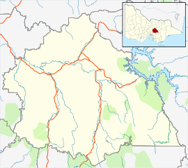
The Shire of Murrindindi is a local government area in the Hume region of Victoria, Australia, located in the north-east part of the state. It covers an area of 3,880 square kilometres (1,500 sq mi) and, in August 2021, had a population of 15,197. It includes the towns of Alexandra, Buxton, Eildon, Flowerdale, Kinglake, Marysville, Molesworth, Strath Creek, Taggerty, Yarck and Yea. It was formed in 1994 from the amalgamation of the Shire of Alexandra, Shire of Yea, and parts of the Shire of Broadford, Shire of Eltham, Shire of Euroa, Shire of Healesville and City of Whittlesea.

<span class="mw-page-title-main">Goulburn River</span> River in Victoria, Australia

The Goulburn River, a major inland perennial river of the Goulburn Broken catchment, part of the Murray-Darling basin, is located in the Alpine, Northern Country/North Central, and Southern Riverina regions of the Australian state of Victoria. The headwaters of the Goulburn River rise in the western end of the Victorian Alps, below the peak of Corn Hill before descending to flow into the Murray River near Echuca, making it the longest river in Victoria at 654 kilometres (406 mi). The river is impounded by the Eildon Dam to create Lake Eildon, the Eildon Pondage, the Goulburn Weir and Waranga Basin.

<span class="mw-page-title-main">Eildon Dam</span> Dam in Victorian Alps, Victoria

The Eildon Dam is a rock and earth-fill embankment dam with a controlled spillway across the Goulburn River, is located between the regional towns of Mansfield and Eildon within Lake Eildon National Park, in the Alpine region of Victoria, Australia. The dam's purpose is for the supply of potable water, irrigation, and the generation of hydroelectricity. The impounded reservoir is called Lake Eildon.

<span class="mw-page-title-main">Yea, Victoria</span> Town in Victoria, Australia

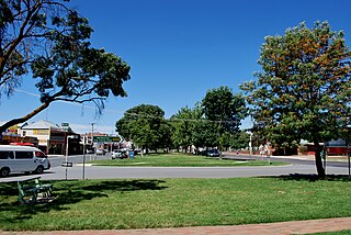
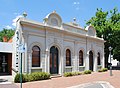
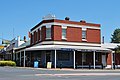
Yea is a town in Victoria, Australia 112 kilometres (70 mi) north-east of the state capital Melbourne at the junction of the Goulburn Valley Highway and the Melba Highway, in the Shire of Murrindindi local government area. In an area originally inhabited by the Taungurung people, it was first visited by Europeans of the Hume and Hovell expedition in 1824, and within 15 years most of the land in the area had been taken up by graziers. Surveyed in 1855, the township grew as a service centre for grazing, gold-mining and timber-getting in the area.

Eildon is a town in central Victoria, Australia. It is located near Lake Eildon, on the Goulburn Valley Highway, in the Shire of Murrindindi local government area. At the 2016 census, Eildon had a population of 974.

<span class="mw-page-title-main">Goulburn Valley</span>

The Goulburn Valley is a sub-region, part of the Hume region of the Australian state of Victoria. The sub-region consists of those areas in the catchment of the Goulburn River and other nearby streams, and is part of the Murray-Darling Basin. The Goulburn Valley is bordered on the south by the Great Dividing Range and to the north by the Murray River, the state border with New South Wales. The sub-region is one of Australia's most productive and intensively farmed areas and is predominantly irrigated.

<span class="mw-page-title-main">Marysville, Victoria</span> Town in Victoria, Australia

Marysville is a town in the Shire of Murrindindi in Victoria, Australia, about 34 kilometres north-east of Healesville and 41 kilometres south of Alexandra. The town, which previously had a population of over 500 people, was devastated by the Murrindindi Mill bushfire on 7 February 2009. On 19 February 2009 the official death toll was 45. Around 90% of the town's buildings were destroyed. Prior to the Black Saturday fire the population in 2006 was 519. At the 2011 Census, the population had reduced to 226, by the 2016 census it had risen to 394.

<span class="mw-page-title-main">Nagambie</span> Town in Victoria, Australia

Nagambie is a town in the Goulburn Valley region of Victoria, Australia. The city is on the Goulburn Valley Freeway north of Seymour and in the Shire of Strathbogie. As of 2021 census, Nagambie had a population of 2,254.

<span class="mw-page-title-main">Delatite River</span> River in Victoria, Australia

The Delatite River, an inland perennial river of the Goulburn Broken catchment, part of the Murray-Darling basin, is located in the lower South Eastern Highlands bioregion and Northern Country/North Central regions of the Australian state of Victoria. The headwaters of the Delatite River rise on the western slopes of the Victorian Alps and descend to flow into the Goulburn River within Lake Eildon.

<span class="mw-page-title-main">Rubicon Hydroelectric Scheme</span> Hydroelectric scheme in Victoria, Australia

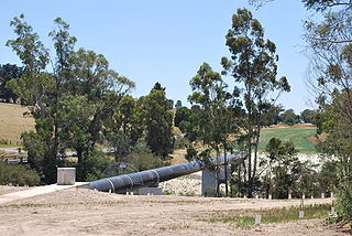
The Rubicon Hydroelectric Scheme is a small run-of-the-river hydroelectric scheme located on the Rubicon and Royston Rivers, north east of Melbourne, 40 km (25 mi) south-west of Alexandra, Victoria, Australia. The scheme commenced in 1922, and was the first state-owned hydroelectric scheme to generate electricity in mainland Australia, and among the first in the world to be remotely controlled. For the first ten years of its operation it supplied on average 16.9% of electricity generated by the State Electricity Commission of Victoria. It is now owned and operated by AGL Energy and contributes approximately 0.02% of Victoria's energy supply.

Since 1 July 2008, Ambulance Victoria has been the sole provider of emergency ambulance services in Victoria, having been formed from the merger of the three previous providers of emergency ambulance services: the Metropolitan Ambulance Service (MAS), Rural Ambulance Victoria (RAV), and the Alexandra District Ambulance Service (ADAS).

<span class="mw-page-title-main">Shire of Alexandra</span> Local government area in Victoria, Australia

The Shire of Alexandra was a local government area located about 130 kilometres (81 mi) northeast of Melbourne, the state capital of Victoria, Australia. The shire covered an area of 2,197.31 square kilometres (848.4 sq mi), and existed from 1868 until 1994.

<span class="mw-page-title-main">Murrindindi, Victoria</span> Place in Victoria, Australia

Murrindindi is a locality along the valley of the Murrindindi River in Victoria, in eastern Australia in the Murrindindi local government area. The nearest town is Yea. At the 2016 census, the suburb of Murrindindi had a population of 107.

<span class="mw-page-title-main">Yea River</span> River in Victoria, Australia

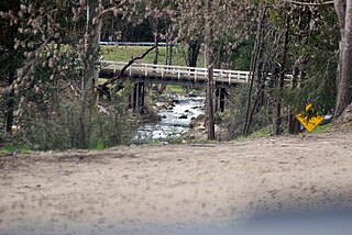
The Yea River, an inland perennial river of the Goulburn Broken catchment, part of the Murray-Darling basin, is located in the lower South Eastern Highlands bioregion and Northern Country/North Central regions of the Australian state of Victoria.

The Alexandra, Eildon, Marysville Standard is a newspaper published by Alexandra Newspapers in Victoria, Australia.

<span class="mw-page-title-main">Murrindindi River</span> River in Victoria, Australia

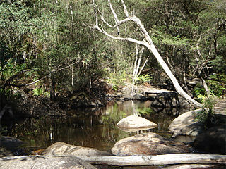
The Murrindindi River, an inland perennial river of the Goulburn Broken catchment, part of the Murray-Darling basin, is located in the lower South Eastern Highlands bioregion and Northern Country/North Central regions of the Australian state of Victoria. The headwaters of the Murrindindi River rise on the western slopes of the Victorian Alps and descend to flow into the Yea River.

ABC Kinglake Ranges was a temporary radio service broadcasting from Kinglake, Victoria, Australia, to areas in the Shire of Murrindindi affected by the Black Saturday bushfires of 2009. The station was first broadcast on 9 March 2009, initially from a makeshift transmitter on 97.1FM. Coverage extended to the towns of Flowerdale and Hazeldene through the local repeater of the Wodonga-based ABC Goulburn Murray service.

Rubicon is a locality in Victoria, Australia, located in the Shire of Murrindindi. It is situated on the Rubicon River. In the 2016 census, Rubicon had a population of 56.

Thornton is a town in nestling on the banks of the Goulburn River in the state of Victoria, Australia. It is in the Shire of Murrindindi local government area. The town is approximately halfway between Alexandra and Eildon. The town had a population of 299 at the 2016 census.

References

Aerial view of Alexandra Alexandra Victoria aerial.jpg
Aerial view of Alexandra
  1. 1 2 "2016 Census QuickStats Alexandra". Australian Bureau of Statistics. Retrieved 26 April 2019.
  2. Patterson, Roy Henry; Jones, Jennifer (2020). On Taungurung Land: Sharing History and Culture. Australian National University Press. p. 13. ISBN   978-1-760-46407-3.
  3. Phoenix Auctions History, Post Office List , retrieved 25 January 2021
  4. 1 2 Kennedy, B: Australian Place Names, page 4. ABC Books, 2006
  5. Sid Brown (March 1990), "Tracks Across the State", Newsrail, Australian Railway Historical Society (Victorian Division): 71–76.
  6. Australian Railway Historical Society Bulletin, November, 1940 pp. 54–55
  7. "Review of Legal Services in Rural and Regional Victoria" (PDF). Parliament of Victoria Law Reform Committee. May 2001. pp. 291–292. Retrieved 12 April 2020.
  8. Turbo (28 April 2010). "UGFM – An Official State Broadcaster – Emergency Information". lakeeildon.com. Retrieved 27 December 2017.
  9. [ permanent dead link ]
  10. Country Racing Victoria, Alexandra Race Club, archived from the original on 17 March 2015, retrieved 7 May 2009
  11. Golf Select, Alexandra , retrieved 11 May 2009
  12. Golf Select, Stonelea , retrieved 11 May 2009