Algansee Township, Michigan

Last updated

Algansee Township, Michigan
Algansee Township, MI location.png
Location within Branch County
USA Michigan location map.svg
Red pog.svg
Algansee Township
Location within the state of Michigan
Usa edcp location map.svg
Red pog.svg
Algansee Township
Location within the United States
Coordinates: 41°51′57″N84°53′53″W / 41.86583°N 84.89806°W / 41.86583; -84.89806
CountryUnited States
State Michigan
County Branch
Established1838
Government
[1]
  SupervisorRuss Jennings
   Clerk Anne Grey
Area
  Total36.09 sq mi (93.47 km2)
  Land35.53 sq mi (92.02 km2)
  Water0.56 sq mi (1.45 km2)
Elevation
1,063 ft (324 m)
Population
 (2020) [2]
  Total2,033
  Density57.2/sq mi (22.1/km2)
Time zone UTC-5 (Eastern (EST))
  Summer (DST) UTC-4 (EDT)
ZIP code(s)
49036 (Coldwater)
49082 (Quincy)
49255 (California)
49274 (Reading)
Area code 517
FIPS code 26-01120 [3]
GNIS feature ID1625816 [4]
Website Official website

Algansee Township is a civil township of Branch County in the U.S. state of Michigan. The population was 2,033 at the 2020 census. [2]

Contents

Communities

History

Algansee Township was created by state legislation on April 2, 1838. It was created from the southern section of Quincy Township and included the land area extending south to the Indiana state line. While the early residents wanted the name of the new township to be named Carlton, it was unexplainably named Alagansee when the township was formally established. The origin of both names is unknown, as the earliest township records have been lost. [7]

Algansee Township assumed its current boundaries on March 25, 1846 when California Township was set off from the southern section of the township. [8] [9]

Geography

According to the U.S. Census Bureau, the township has a total area of 36.09 square miles (93.47 km2), of which 35.53 square miles (92.02 km2) is land and 0.56 square miles (1.45 km2) (1.55%) is water. [10]

Demographics

As of the census [3] of 2000, there were 2,061 people, 746 households, and 561 families residing in the township. The population density was 58.0 inhabitants per square mile (22.4/km2). There were 970 housing units at an average density of 27.3 per square mile (10.5/km2). The racial makeup of the township was 98.69% White, 0.19% African American, 0.19% Native American, 0.29% from other races, and 0.63% from two or more races. Hispanic or Latino of any race were 0.92% of the population.

There were 746 households, out of which 31.5% had children under the age of 18 living with them, 65.4% were married couples living together, 5.2% had a female householder with no husband present, and 24.7% were non-families. 20.5% of all households were made up of individuals, and 8.6% had someone living alone who was 65 years of age or older. The average household size was 2.71 and the average family size was 3.12.

In the township the population was spread out, with 28.0% under the age of 18, 5.9% from 18 to 24, 26.9% from 25 to 44, 25.9% from 45 to 64, and 13.3% who were 65 years of age or older. The median age was 38 years. For every 100 females, there were 105.9 males. For every 100 females age 18 and over, there were 103.2 males.

The median income for a household in the township was $42,794, and the median income for a family was $44,130. Males had a median income of $30,625 versus $22,051 for females. The per capita income for the township was $18,299. About 4.8% of families and 7.7% of the population were below the poverty line, including 8.4% of those under age 18 and 3.6% of those age 65 or over.

Notable people

Related Research Articles

<span class="mw-page-title-main">Irving Township, Michigan</span> Township in Michigan, United States

Irving Township is a civil township of Barry County in the U.S. state of Michigan. The population was 3,250 at the 2010 census, up from 2,682 in 2000.

<span class="mw-page-title-main">Hatton Township, Michigan</span> Civil township in Michigan, United States

Hatton Township is a civil township of Clare County in the U.S. state of Michigan. The population was 893 at the 2020 census.

<span class="mw-page-title-main">Dallas Township, Michigan</span> Civil township in Michigan, United States

Dallas Township is a civil township of Clinton County in the U.S. state of Michigan. The population was 2,369 at the 2010 census. The township was established in 1845 from a section of Lebanon Township and named for vice president George M. Dallas.

<span class="mw-page-title-main">Ovid Township, Clinton County, Michigan</span> Civil township in Michigan, United States

Ovid Township is a civil township of Clinton County in the U.S. state of Michigan. As of the 2010 census, the township had a population of 3,795. The population has decreased significantly after the village of Ovid separated from the township and incorporated into a city in 2015.

<span class="mw-page-title-main">Allen Township, Michigan</span> Civil township in Michigan, United States

Allen Township is a civil township of Hillsdale County in the U.S. state of Michigan. The population was 1,334 at the 2020 census.

<span class="mw-page-title-main">Nottawa Township, Isabella County, Michigan</span> Civil township in Michigan, United States

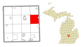
Nottawa Township is a civil township of Isabella County in the U.S. state of Michigan. The population was 2,225 at the 2020 census.

<span class="mw-page-title-main">Spring Arbor Township, Michigan</span> Civil township in Michigan, United States

Spring Arbor Township is a civil township of Jackson County in the U.S. state of Michigan. The population was 8,267 at the 2010 census, up from 7,577 at the 2000 census.

Cleon Township is a civil township of Manistee County located in the U.S. state of Michigan. The population was 1,063 at the 2020 census, up from 957 in 2010.

Marilla Township is a civil township of Manistee County in the U.S. state of Michigan. The population was 398 at the 2020 census.

<span class="mw-page-title-main">West Branch Township, Marquette County, Michigan</span> Civil township in Michigan, United States

West Branch Township is a civil township of Marquette County in the U.S. state of Michigan. The population was 1,702 at the 2020 census.

<span class="mw-page-title-main">Branch Township, Michigan</span> Civil township in Michigan, United States

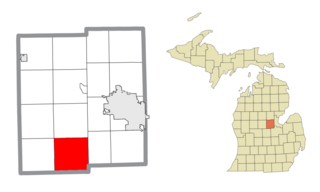
Branch Township is a civil township of Mason County in the U.S. state of Michigan. As of the 2020 census, the township population was 1,405. Branch Township was named after Branch County, Michigan.

<span class="mw-page-title-main">Logan Township, Mason County, Michigan</span> Civil township in Michigan, United States

Logan Township is a civil township of Mason County in the U.S. state of Michigan. The population was 329 at the 2020 census.

<span class="mw-page-title-main">Sherman Township, Mason County, Michigan</span> Civil township in Michigan, United States

Sherman Township is a civil township of Mason County in the U.S. state of Michigan. The population was 1,127 at the 2020 census.

Fork Township is a civil township of Mecosta County in the U.S. state of Michigan. The population was 1,627 at the 2020 census.

<span class="mw-page-title-main">Daggett Township, Michigan</span> Civil township in Michigan, United States

Daggett Township is a civil township of Menominee County in the U.S. state of Michigan. The population was 614 at the 2020 census, down from 714 in 2010. The village of Daggett is located within the township.

<span class="mw-page-title-main">Porter Township, Midland County, Michigan</span> Civil township in Michigan, United States

Porter Township is a civil township of Midland County in the U.S. state of Michigan. The population was 1,270 at the 2020 census.

<span class="mw-page-title-main">Forest Township, Missaukee County, Michigan</span> Civil township in Michigan, United States

Forest Township is a civil township of Missaukee County in the U.S. state of Michigan. The population was 1,184 at the 2020 census.

<span class="mw-page-title-main">West Branch Township, Ogemaw County, Michigan</span> Civil township in Michigan, United States

West Branch Township is a civil township of Ogemaw County in the U.S. state of Michigan. The population was 2,593 at the 2010 census. The city of West Branch is mostly surrounded by the township, but the two are administered autonomously.

<span class="mw-page-title-main">Hopewell Township, Bedford County, Pennsylvania</span> Township in Pennsylvania, United States

Hopewell Township is a township in Bedford County, Pennsylvania, United States. The population was 1,882 at the 2020 census.

<span class="mw-page-title-main">West Branch Township, Missaukee County, Michigan</span> Civil township in Michigan, United States

West Branch Township is a civil township of Missaukee County in the U.S. state of Michigan. The population was 452 at the 2020 census.

References

  1. Michigan Townships Association (2023). "Algansee Township, Branch County, Michigan" . Retrieved July 8, 2023.
  2. 1 2 United States Census Bureau. "Algansee Township, Branch County, Michigan" . Retrieved July 4, 2023.
  3. 1 2 "U.S. Census website". United States Census Bureau . Retrieved January 31, 2008.
  4. U.S. Geological Survey Geographic Names Information System: Algansee Township, Michigan
  5. U.S. Geological Survey Geographic Names Information System: Algansee, Michigan
  6. Romig, Walter (October 1, 1986) [1973]. Michigan Place Names: The History of the Founding and the Naming of More Than Five Thousand Past and Present Michigan Communities. p. 16. ISBN   978-0-8143-1838-6.{{cite book}}: |work= ignored (help)
  7. Algansee Township (2023). "Algansee Township History" . Retrieved July 2, 2023.
  8. Collin, Henry Park. A twentieth century history and biographical record of Branch County, Michigan New York, Chicago: Lewis Publishing Co., 1906. pp. 87-90
  9. Johnson, Crisfield. History of Branch county, Michigan, with illustrations and biographical sketches of some of its prominent men and pioneers. Philadelphia: Everts & Abbott, 1879. pp. 239
  10. "Michigan: 2010 Population and Housing Unit Counts 2010 Census of Population and Housing" (PDF). 2010 United States census . United States Census Bureau. September 2012. p. 17 Michigan. Archived (PDF) from the original on October 19, 2012. Retrieved July 6, 2023.