Quincy, Michigan

Last updated

Quincy, Michigan
Village of Quincy
US 12 (so side) 19-07-19 140.jpg
Downtown Quincy along U.S. Route 12
Quincy, MI location.png
Location within Branch County
USA Michigan location map.svg
Red pog.svg
Quincy
Location within the state of Michigan
Usa edcp location map.svg
Red pog.svg
Quincy
Location within the United States
Coordinates: 41°56′40″N84°53′09″W / 41.94444°N 84.88583°W / 41.94444; -84.88583
CountryUnited States
State Michigan
County Branch
Township Quincy
Settled1830
Incorporated1858
Government
[1]
  Type Village council
  PresidentMike Hagaman
   Clerk Marci Clancy
   Manager Brittany Butler
Area
[2]
  Total1.56 sq mi (4.04 km2)
  Land1.56 sq mi (4.04 km2)
  Water0.00 sq mi (0.00 km2)
Elevation
1,017 ft (310 m)
Population
 (2020) [3]
  Total1,554
  Density996.15/sq mi (384.63/km2)
Time zone UTC-5 (Eastern (EST))
  Summer (DST) UTC-4 (EDT)
ZIP code(s)
49082
Area code 517
FIPS code 26-66640 [4]
GNIS feature ID0635567 [5]
Website Official website

Quincy is a village in Branch County in the U.S. state of Michigan. The population was 1,554 at the 2020 census. [3] The village is centered along U.S. Route 12 within Quincy Township.

Contents

History

The area was first settled by Horace Wilson, who first purchased land in 1830. He purchased 360 acres (150 ha) of land from the government. John Cornish became the first permanent resident when he built his house here in 1833. The area would be set aside from Coldwater Township and organized as Quincy Township in 1836. The township and community were named Quincy on the suggestion from Dr. Hiram Allen, who recently moved to the area from Quincy, Massachusetts. A post office named Quincy began operating on December 16, 1836. The Lake Shore and Michigan Southern Railway built a depot in Quincy, and the community incorporated as a village in 1858. [6]

Geography

According to the U.S. Census Bureau, the village has a total area of 1.56 square miles (4.04 km2), all land. [2]

Major highways

Demographics

Historical population
CensusPop.Note
1870 1,092
1880 1,1202.6%
1890 1,25011.6%
1900 1,56325.0%
1910 1,347−13.8%
1920 1,251−7.1%
1930 1,2651.1%
1940 1,3335.4%
1950 1,52714.6%
1960 1,6024.9%
1970 1,540−3.9%
1980 1,5691.9%
1990 1,6807.1%
2000 1,7011.3%
2010 1,652−2.9%
2020 1,554−5.9%
U.S. Decennial Census [7]

2010 census

As of the census [8] of 2010, there were 1,652 people, 634 households, and 436 families living in the village. The population density was 1,354.1 inhabitants per square mile (522.8/km2). There were 743 housing units at an average density of 609.0 per square mile (235.1/km2). The racial makeup of the village was 96.9% White, 0.5% African American, 0.2% Native American, 0.4% Asian, 0.6% from other races, and 1.3% from two or more races. Hispanic or Latino of any race were 2.5% of the population.

There were 634 households, of which 40.5% had children under the age of 18 living with them, 41.5% were married couples living together, 18.9% had a female householder with no husband present, 8.4% had a male householder with no wife present, and 31.2% were non-families. 25.1% of all households were made up of individuals, and 7.7% had someone living alone who was 65 years of age or older. The average household size was 2.61 and the average family size was 3.02.

The median age in the village was 33.1 years. 29.6% of residents were under the age of 18; 10.3% were between the ages of 18 and 24; 25.5% were from 25 to 44; 26.5% were from 45 to 64; and 8.2% were 65 years of age or older. The gender makeup of the village was 49.4% male and 50.6% female.

2000 census

As of the census [4] of 2000, there were 1,701 people, 640 households, and 435 families living in the village. The population density was 1,327.0 inhabitants per square mile (512.4/km2). There were 687 housing units at an average density of 536.0 per square mile (207.0/km2). The racial makeup of the village was 97.24% White, 0.29% African American, 0.24% Native American, 0.24% Asian, 0.18% Pacific Islander, 1.18% from other races, and 0.65% from two or more races. Hispanic or Latino of any race were 2.35% of the population.

There were 640 households, out of which 41.6% had children under the age of 18 living with them, 45.0% were married couples living together, 17.3% had a female householder with no husband present, and 31.9% were non-families. 26.3% of all households were made up of individuals, and 8.1% had someone living alone who was 65 years of age or older. The average household size was 2.61 and the average family size was 3.10.

In the village, the population was spread out, with 31.5% under the age of 18, 9.8% from 18 to 24, 29.1% from 25 to 44, 19.9% from 45 to 64, and 9.7% who were 65 years of age or older. The median age was 32 years. For every 100 females, there were 95.3 males. For every 100 females age 18 and over, there were 91.6 males.

The median income for a household in the village was $35,987, and the median income for a family was $38,839. Males had a median income of $29,602 versus $22,188 for females. The per capita income for the village was $15,951. About 8.6% of families and 10.6% of the population were below the poverty line, including 13.4% of those under age 18 and 14.1% of those age 65 or over.

Notable people

Images

Related Research Articles

<span class="mw-page-title-main">Bellaire, Michigan</span> Village in Michigan, United States

Bellaire is a village and the county seat of Antrim County, Michigan, United States. The population was 1,053 in 2020 census.

<span class="mw-page-title-main">Quincy Township, Branch County, Michigan</span> Civil township in Michigan, United States

Quincy Township is a civil township of Branch County in the U.S. state of Michigan. The population was 4,108 at the 2020 census.

<span class="mw-page-title-main">Athens, Michigan</span> Village in Michigan, United States

Athens is a village in Calhoun County in the U.S. state of Michigan. The population was 936 at the 2020 census. The village is located in southern Athens Township, and is part of the Battle Creek, Michigan Metropolitan Statistical Area. It was settled in 1831.

<span class="mw-page-title-main">Allen, Michigan</span> Village in Michigan, United States

Allen is a village in Hillsdale County in the U.S. state of Michigan. The population was 201 at the 2020 census.

<span class="mw-page-title-main">Allen Township, Michigan</span> Civil township in Michigan, United States

Allen Township is a civil township of Hillsdale County in the U.S. state of Michigan. The population was 1,334 at the 2020 census.

<span class="mw-page-title-main">Kinde, Michigan</span> Village in Michigan, United States

Kinde is a village in Huron County in the U.S. state of Michigan. The population was 448 at the 2010 census.

<span class="mw-page-title-main">Stockbridge, Michigan</span> Village in Michigan, United States

Stockbridge is a village in Ingham County in the U.S. state of Michigan. It is located within Stockbridge Township about 36 miles (58 km) southeast from downtown Lansing. The population was 1,218 at the 2010 census.

<span class="mw-page-title-main">Lyons, Michigan</span> Village in Michigan, United States

Lyons is a village in Ionia County in the U.S. state of Michigan. The population was 789 at the 2010 census. Most of the village is within Lyons Township. A small portion extends west into Ionia Township.

<span class="mw-page-title-main">Clinton, Lenawee County, Michigan</span> Village in Michigan, United States

Clinton is a village in Lenawee County in the Irish Hills area of the U.S. state of Michigan. The population was 2,336 at the 2010 census. The village is located within Clinton Township.

<span class="mw-page-title-main">Conway Township, Michigan</span> Civil township in Michigan, United States

Conway Township is a civil township of Livingston County in the U.S. state of Michigan. The population was 3,608 at the 2020 census, an increase from 3,546 at the 2010 census.

<span class="mw-page-title-main">Lakeview, Michigan</span> Village in Michigan, United States

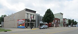
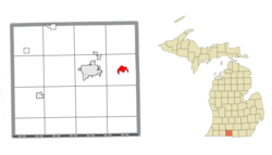
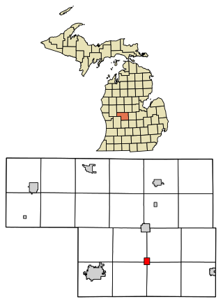
Lakeview is a village in Cato Township in Montcalm County of the U.S. state of Michigan. The population was 1,024 at the 2020 census.

<span class="mw-page-title-main">Pierson, Michigan</span> Village in Michigan, United States

Pierson is a village in Montcalm County of the U.S. state of Michigan. The population was 229 at the 2020 census, up from 172 in 2010. The village is within Pierson Township.

<span class="mw-page-title-main">Sheridan, Michigan</span> Village in Michigan, United States

Sheridan is a village in Montcalm County in the U.S. state of Michigan. The population was 692 at the 2020 census, up from 649 in 2010. The village is located at the corners of four townships and incorporates land from each: Evergreen Township to the northeast, Bushnell Township to the southeast, Fairplain Township to the southwest, and Sidney Township to the northwest.

<span class="mw-page-title-main">Milford Township, Michigan</span> Charter township in Michigan, United States

Milford Township is a charter township of Oakland County in the U.S. state of Michigan. The population was 17,090 at the 2020 census. The village of Milford is located within the township.

<span class="mw-page-title-main">Ortonville, Michigan</span> Village in Michigan, United States

Ortonville is a village in north Oakland County in the U.S. state of Michigan. The village is within Brandon Township, although some development near the village lies within adjacent Oakland County, Groveland township and Lapeer County, Hadley township. The population was 1,291 as of the 2021 Census estimate. Ortonville lies on the northern edge of Metro Detroit and is approximately 41 miles north of Downtown Detroit.

<span class="mw-page-title-main">Applegate, Michigan</span> Village in Michigan, United States

Applegate is a village in Sanilac County of the U.S. state of Michigan. The population was 241 at the 2020 census. Applegate is in the southeast corner of Washington Township on the boundary with Sanilac Township.

<span class="mw-page-title-main">Akron, Michigan</span> Village in Michigan, United States

Akron is a village in Tuscola County of the U.S. state of Michigan. The population was 349 at the 2020 census.

<span class="mw-page-title-main">Breedsville, Michigan</span> Village in Michigan, United States

Breedsville is a village in Van Buren County of the U.S. state of Michigan. The population was 199 at the 2010 census. The village is within Columbia Township.

<span class="mw-page-title-main">Mesick, Michigan</span> Village in Michigan, United States

Mesick is a village in Wexford County in the U.S. state of Michigan. The population was 397 at the 2020 census. The majority of the village is located within Springville Township with a very small portion extending east into Antioch Township.

Lennon is a village in the U.S. state of Michigan. The population was 511 at the 2010 census. The village is located along M-13 within Venice Township in Shiawassee County to the west and Clayton Township in Genesee County to the east.

References

  1. Village of Quincy (2023). "Quincy: Government" . Retrieved June 27, 2023.
  2. 1 2 "2020 U.S. Gazetteer Files". United States Census Bureau. Retrieved May 21, 2022.
  3. 1 2 United States Census Bureau (June 24, 2023). "Quincy Village; Michigan".
  4. 1 2 "U.S. Census website". United States Census Bureau . Retrieved January 31, 2008.
  5. U.S. Geological Survey Geographic Names Information System: Quincy, Michigan
  6. Romig, Walter (October 1, 1986) [1973]. Michigan Place Names: The History of the Founding and the Naming of More Than Five Thousand Past and Present Michigan Communities (Paperback). Great Lakes Books Series. Detroit, Michigan: Wayne State University Press. p. 463. ISBN   978-0-8143-1838-6.
  7. "Census of Population and Housing". Census.gov. Retrieved June 4, 2015.
  8. "U.S. Census website". United States Census Bureau . Retrieved November 25, 2012.