Alisal, or El Alisal (The Sycamores), was a Californio settlement located on the lands of the Rancho Santa Rita near the site of an Indian ranchera, around the Francisco Solano Alviso Adobe, called El Alisal (The Sycamores), [1] one of the earliest houses built in the Livermore Valley in 1844. Note that even though the database and plaque use the word "sycamore", the English translation of the Spanish "aliso" is "alder".
Alisal, nicknamed "The Most Desperate Town in the West", [2] was one of the settlements located along the trail called La Vereda del Monte that was a haunt and refuge of bandits and desperados in the era following the beginning of the California Gold Rush. Main Street shootouts were not uncommon. Banditos such as Claudio Feliz and Joaquin Murrieta would ambush prospectors on their way back from the gold fields and then seek refuge in Alisal. In the 1860s and 1870s Procopio, Narciso Bojorques and others took refuge there. [3]
During the period of the railroad boom in the late 1860s, Rancho Santa Rita was sub divided. In 1869 J.W. Kottinger and J.A. Neal each laid out and plotted a subdivision for a new town called Alisal, situated about five miles south of Dublin. By 1878 the village was an unincorporated town of about 500 people.
Alisal was later included within Pleasanton, California that was founded in 1894.

Pleasanton is a city in Alameda County, California, United States. Located in the Amador Valley, it is a suburb in the East Bay region of the San Francisco Bay Area. The population was 79,871 at the 2020 census. In 2005 and 2007, Pleasanton was ranked the wealthiest middle-sized city in the United States by the Census Bureau. Pleasanton is home to the headquarters of Safeway, Workday, Ellie Mae, Roche Molecular Diagnostics, Blackhawk Network Holdings, and Veeva Systems. Other major employers include Kaiser Permanente, Oracle and Macy's. Although Oakland is the Alameda County seat, a few county offices are located in Pleasanton. The Alameda County Fairgrounds are located in Pleasanton, where the county fair is held during the last week of June and the first week of July. Pleasanton Ridge Regional Park is located on the west side of town.

Alviso is a district of San Jose, California, located in North San Jose on the southern shores of San Francisco Bay. Originally an independent town, founded in 1852, today Alviso is San Jose's only waterfront district, primarily residential in nature, with several Silicon Valley tech companies and recreation-oriented businesses. Alviso is named after 19th-century Californio ranchero Ignacio Alviso, who owned the area as part of his Rancho Rincón de Los Esteros.
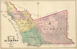
Murray Township was a township located in what is now the Livermore Valley portion of Alameda County, California, including the present day cities of Livermore, Dublin, and Pleasanton, and the census-designated place of Sunol.

Rancho Milpitas was a 4,458-acre (18.04 km2) Mexican land grant in Santa Clara County, California. The name comes from the Nahuatl word for maize and could be translated "little cornfields". The grant included what is now the city of Milpitas.

Rancho San Francisco was a land grant in present-day northwestern Los Angeles County and eastern Ventura County, California. It was a grant of 48,612 acres (19,673 ha) by Governor Juan B. Alvarado to Antonio del Valle, a Mexican army officer, in recognition for his service to Alta California. It is not related to the city of San Francisco.
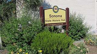
Sonoma State Historic Park is a California State Park located in the center of Sonoma, California. The park consists of six sites: the Mission San Francisco Solano, the Sonoma Barracks, the Blue Wing Inn, La Casa Grande, Lachryma Montis, and the Toscano Hotel.
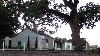
The Alviso Adobe Community Park is a 7-acre (2.8 ha) park in the city of Pleasanton, California, United States. It is built around an adobe house constructed in 1854 by Francisco Alviso on the Rancho Santa Rita Mexican Land Grant. The Alviso Adobe is a rare surviving example of an early American adobe that was continuously in use until 1969. The building is registered as California Historical Landmark #510 in 1954, but most of the historical marker was later found to be erroneous.

Milpitas is a city in Santa Clara County, California, in Silicon Valley. As of the 2020 census, the city population was 80,273. The city's origins lie in Rancho Milpitas, granted to Californio ranchero José María Alviso in 1835. Milpitas incorporated in 1954 and has since become home to numerous high tech companies, as part of Silicon Valley.
Alisal is a Spanish word for "alder grove". It may refer to:
Rancho Santa Rita was a 8,894-acre (35.99 km2) Mexican land grant in the Amador Valley and western Livermore Valley, which is in present day Alameda County, California.

Adobe Creek, historically San Antonio Creek, is a 14.2-mile-long (22.9 km) northward-flowing stream originating on Black Mountain in the Santa Cruz Mountains. It courses through the cities of Los Altos Hills, Los Altos, and Palo Alto on its way to the Palo Alto Flood Basin and thence to southwestern San Francisco Bay in Santa Clara County, California, United States. Historically, Adobe Creek was a perennial stream and hosted runs of steelhead trout entering from the Bay, but these salmonids are now blocked by numerous flood control structures, including a tidal gate at the creek's mouth and a long concretized rectangular channel culminating in an impassable drop structure at El Camino Real. The co-founders of Adobe Systems both lived on Adobe Creek.
Rancho El Alisal was a 8,912-acre (36.07 km2) Mexican land grant in present-day Monterey County, California, given in 1833 by Governor José Figueroa to the brothers Feliciano and Mariano Soberanes and to William Edward Petty Hartnell. Alisal means Alder tree (sycamore) in Spanish. The land is approximately four miles southeast of present-day Salinas.
Rancho Sanjon de Santa Rita was a 48,824-acre (197.58 km2) Mexican land grant mostly in present-day Merced County, California and also a small part in Fresno County, California given in 1841 by Governor Juan Alvarado to Francisco Maria Soberanes. Sanjon is Spanish for ditch or deep slough. The grant was west of the San Joaquin River and encompassed present-day Santa Rita Park and Dos Palos Y.
Rancho Los Coches was a 8,794-acre (35.59 km2) Mexican land grant in present day Monterey County, California given in 1841 by Governor Juan Alvarado to María Josefa Soberanes. The name means "the pigs". The grant was south of Soledad and extended along the Arroyo Seco.
Rancho Santa Teresa was a 9,647-acre (39.04 km2) Mexican land grant in present-day Santa Clara County, California given in 1834 by Governor José Figueroa to José Joaquín Bernal. The grant extended west from Coyote Creek to the Santa Teresa Hills, and included present-day Santa Teresa.
Rancho Valle de San José was a 48,436-acre (196.01 km2) Mexican land grant in present-day Alameda County, California. It was made up of the former pasture land belonging to Mission San José.

Matadero Creek is a stream originating in the foothills of the Santa Cruz Mountains in Santa Clara County, California, United States. The creek flows in a northeasterly direction for 8 miles (13 km) until it enters the Palo Alto Flood Basin, where it joins Adobe Creek in the Palo Alto Baylands at the north end of the Mayfield Slough, just before its culmination in southwest San Francisco Bay. Matadero Creek begins in the city of Los Altos Hills, then traverses the Stanford University lands and Palo Alto.

Rancho Rincón del Sanjón was a 2,230-acre (9.0 km2) Mexican land grant in present-day Monterey County, California given in 1840 by Governor Juan B. Alvarado to José Eusebio Boronda. The name means "corner of Sanjo del Alisal". The grant was located on the north side of the Sanjo del Alisal,, between Cooper's Rancho Bolsa del Potrero y Moro Cojo on the west, Castro's Rancho Sausal on the east, and bordering Espinosa's Rancho Bolsa de las Escorpinas on the north. The grant was on the northwest of present-day Salinas, where Boronda, California is located.

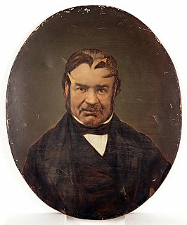
José María Amador was a Californio ranchero, gold miner, and soldier. Amador County and Amador City are both named after Amador, having found gold there in 1848. He is also the namesake of Amador Valley, a component of the Tri-Valley in Alameda County.
