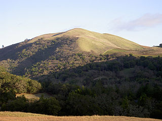
Midway, Alameda County, California

Last updated

Coordinates: 37°42′53″N121°33′29″W / 37.71472°N 121.55806°W / 37.71472; -121.55806

Geographic coordinate system Coordinate system

A geographic coordinate system is a coordinate system that enables every location on Earth to be specified by a set of numbers, letters or symbols. The coordinates are often chosen such that one of the numbers represents a vertical position and two or three of the numbers represent a horizontal position; alternatively, a geographic position may be expressed in a combined three-dimensional Cartesian vector. A common choice of coordinates is latitude, longitude and elevation. To specify a location on a plane requires a map projection.

Midway
Unincorporated community
California Locator Map with US.PNG
Red pog.svg
Midway
Location in California
Usa edcp location map.svg
Red pog.svg
Midway
Midway (the US)
Coordinates: 37°42′53″N121°33′29″W / 37.71472°N 121.55806°W / 37.71472; -121.55806
Country United States
State California
County Alameda County
Elevation [1] 358 ft (109 m)

Midway is an unincorporated community in Alameda County, California, 6 miles (9.7 km) south-southeast of Altamont. [2] It lies at an elevation of 358 feet (109 m). A post office operated in Midway from 1870 to 1918. [2]

Unincorporated area Region of land not governed by own local government

In law, an unincorporated area is a region of land that is not governed by a local municipal corporation; similarly an unincorporated community is a settlement that is not governed by its own local municipal corporation, but rather is administered as part of larger administrative divisions, such as a township, parish, borough, county, city, canton, state, province or country. Occasionally, municipalities dissolve or disincorporate, which may happen if they become fiscally insolvent, and services become the responsibility of a higher administration. Widespread unincorporated communities and areas are a distinguishing feature of the United States and Canada. In most other countries of the world, there are either no unincorporated areas at all, or these are very rare; typically remote, outlying, sparsely populated or uninhabited areas.

Alameda County, California County in California

Alameda County is a county in the state of California in the United States. As of the 2010 census, the population was 1,510,271, making it the 7th-most populous county in the state. The county seat is Oakland. Alameda County is included in the San Francisco Bay Area, occupying much of the East Bay region.

California State of the United States of America

California is a state in the Pacific Region of the United States. With 39.6 million residents, California is the most populous U.S. state and the third-largest by area. The state capital is Sacramento. The Greater Los Angeles Area and the San Francisco Bay Area are the nation's second and fifth most populous urban regions, with 18.7 million and 9.7 million residents respectively. Los Angeles is California's most populous city, and the country's second most populous, after New York City. California also has the nation's most populous county, Los Angeles County, and its largest county by area, San Bernardino County. The City and County of San Francisco is both the country's second-most densely populated major city after New York City and the fifth-most densely populated county, behind only four of the five New York City boroughs.

Related Research Articles

Centerville, Butte County, California Unincorporated community in California, United States

Centerville is an unincorporated community in Butte County, California along Butte Creek. It was midway between Helltown and Diamondville. The area is about one and three quarters miles, straight-line distance, west of Paradise.

Barber, California Place in California, United States

The Barber Neighborhood is a working class residential neighborhood in Chico, California, generally south of Little Chico Creek and west of Park avenue. The Barber Neighborhood Association represents the interests of the neighborhood to the community. This neighborhood was originally the settlement of Barber, California built to house the employees of the adjacent Diamond Match Factory. The neighborhood was named after Ohio Columbus Barber, president of the Diamond Match Company. The neighborhood lies at an elevation of 190 feet. Today, the area is entirely within the city limits of Chico, and the Diamond Match property is designated for a future development called Barber Yard. Some of the notable and historic structures in the neighborhood are:

Bald Mountain (California) name given to over fifty summits in California

Bald Mountain is a name given to over fifty summits in California.

Yuman, California Former settlement in California, United States

Yuman is a former Maidu settlement in Butte County, California. It lay at an elevation of 171 feet. Its location is currently within the city limits of Oroville.

Curtner is a neighborhood of Fremont in Alameda County, California. It lies at an elevation of 30 feet. It was formerly an unincorporated community.

Elliot, California Former settlement in California, United States

Elliot is a former settlement in Alameda County, California. It was located on the Southern Pacific Railroad 4 miles (6.4 km) west of Livermore, at an elevation of 374 feet. It still appeared on maps as of 1906.

Greenville, Alameda County, California Former settlement in California, United States

Greenville is a former settlement in Alameda County, California. It was located 2.5 miles (4.0 km) southwest of Altamont, at an elevation of 584 feet. The name is in honor of John Green, first store owner here.

Komandorski Village, California Unincorporated community in California, United States

Komandorski Village is an unincorporated community in Alameda County, California. It is located 2 miles (3.2 km) northeast of Dublin, at an elevation of 371 feet.

Mallard, California Former settlement in California, United States

Mallard is a former settlement in Alameda County, California. It was located on the Southern Pacific Railroad 1 mile east-southeast of the present downtown Fremont, at an elevation of 52 feet.

Mendenhall Springs, California Unincorporated community in California, United States

Mendenhall Springs is an unincorporated community in Alameda County, California. It is located 9 miles (14 km) southeast of Livermore, at an elevation of 1818 feet.

Merienda, California Former settlement in California, United States

Merienda is a former settlement in Niles Canyon, in Alameda County, California. It lay at an elevation of 112 feet. It still appeared on maps as of 1906. In 1917, the people moved to Alston, which in turn became Dresser.

Remillard, California Former settlement in California, United States

Remillard is a former settlement in Alameda County, California, 5 miles (8 km) west of Livermore. It lay at an elevation of 371 feet. It was the site of a brick works owned by the Remillard Brothers from 1889 to 1935.

Robert, California Former settlement in California, United States

Robert is a former settlement in Alameda County, California. It lay at an elevation of 13 feet.

San Ramon Village, California Unincorporated community in California, United States

San Ramon Village is an unincorporated community in Alameda County, California. It is located north-northeast of Dublin, at an elevation of 354 feet.

Scotts Corner, California Unincorporated community in California, United States

Scotts Corner is an unincorporated community in Alameda County, California. It is 1 mile (1.6 km) east-southeast of Sunol, at an elevation of 259 feet. The name is in honor of Thomas Scott, Sr., who opened a store here in the 1850s.

Snoboy is a former unincorporated community now annexed to Fremont in Alameda County, California. It lies at an elevation of 30 feet.

Ulmar is a former unincorporated community now annexed to Livermore in Alameda County, California. It lies at an elevation of 554 feet.

Verona, California Unincorporated community in California, United States

Verona is an unincorporated community in Alameda County, California. It is located on the Western Pacific and the Southern Pacific Railroads 2.25 miles (3.6 km) north of Sunol, at an elevation of 315 feet.

The Pines, Butte County, California Unincorporated community in California, United States

The Pines is an unincorporated community in Butte County, California, United States.

Kellogg Creek is a tributary of Indian Slough, in Contra Costa County, California. Indian Slough itself is a tributary of the Old River, an old channel of the San Joaquin River. Kellogg Creek was formerly named Arroyo Santa Ángela de Fulgino by Pedro Font, on April 4, 1776, as the expedition of Juan Bautista de Anza passed through the area. In the 19th century it was known to the Californios as Arroyo del Sur.

References

  1. U.S. Geological Survey Geographic Names Information System: Midway, Alameda County, California
  2. 1 2 Durham, David L. (1998). California's Geographic Names: A Gazetteer of Historic and Modern Names of the State. Clovis, Calif.: Word Dancer Press. p. 663. ISBN   1-884995-14-4.