Dublin is a suburban city of the East Bay and Tri-Valley regions of Alameda County, California, United States. It is located along the north side of Interstate 580 at the intersection with Interstate 680, roughly 35 miles (56 km) east of downtown San Francisco, 23 miles (37 km) east of downtown Oakland, and 31 miles (50 km) north of downtown San Jose.

Pleasanton is a city in Alameda County, California, incorporated in 1894. It is a suburb in the San Francisco Bay Area located about 25 miles (40 km) east of Oakland, and 6 miles (9.7 km) west of Livermore. The population was 70,285 at the 2010 census. In 2005 and 2007, Pleasanton was ranked the wealthiest middle-sized city in the United States by the Census Bureau. Pleasanton is home to the headquarters of Safeway, Workday, Ellie Mae, Roche Molecular Diagnostics, Blackhawk Network Holdings, and Veeva Systems. Other major employers include Kaiser Permanente, Oracle, Nordstrom and Macy's. Although Oakland is the Alameda County seat, a few county offices are located in Pleasanton. The Alameda County Fairgrounds are located in Pleasanton, where the county fair is held during the last week of June and the first week of July. Pleasanton Ridge Regional Park is located on the west side of town.

San Ramon is a city in Contra Costa County, California, United States, located within the San Ramon Valley, and 34 miles east of San Francisco. San Ramon's population was estimated as 75,995 in 2019 by the US Census Bureau, making it the 4th largest city in Contra Costa County, behind Richmond, Concord and Antioch.

Mission Hills is an urban residential community of the San Fernando Valley, within the city of Los Angeles, California.

The Tri-Valley area is a triangle-shaped region of the eastern San Francisco Bay Area, 18 miles southeast of Oakland and 33 miles from San Francisco. It encompasses the cities of Dublin, Livermore, Pleasanton and San Ramon, the town of Danville and the CDPs of Alamo, Blackhawk and Diablo.

WHEELS is a bus service that provides public transportation in the Tri-Valley Region of the San Francisco Bay Area, in the United States. Started in 1986, Wheels offers service to various communities in three cities, and connects to Bay Area Rapid Transit (BART) and Altamont Corridor Express (ACE) trains for connections to and from the greater Bay Area and Central Valley.

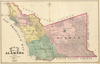
Murray Township was a township located in what is now the Livermore Valley portion of Alameda County, California, including the present day cities of Livermore, Dublin, and Pleasanton, and the census-designated place of Sunol.

The Crescenta Valley is a small inland valley in Los Angeles County, California, lying between the San Gabriel Mountains on the northeast and the Verdugo Mountains and San Rafael Hills on the southwest. It opens into the San Fernando Valley at the northwest and the San Gabriel Valley at the southeast. It is nearly bisected by the Verdugo Wash, a smaller valley separating the Verdugo Mountains from the San Rafael Hills. Most of the valley lies at an elevation of over 1,500 feet.

Robert Thomas Livermore was an English-born rancher and landowner influential in the early days of California. His holdings eventually formed the basis of the city that bears his name: Livermore, California.

Las Positas College (LPC) is a public community college in Livermore, California.

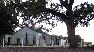
The Alviso Adobe Community Park is a 7-acre (2.8 ha) park in the city of Pleasanton, California, United States. It is built around an adobe house constructed in 1854 by Francisco Alviso on the Rancho Santa Rita Mexican Land Grant. The Alviso Adobe is a rare surviving example of an early American adobe that was continuously in use until 1969. The building is registered as California Historical Landmark #510 in 1954, but most of the historical marker was later found to be erroneous.

Warner Springs is a small unincorporated community in northern San Diego County, California.

Clinton is a small town in Amador County, California. It is located 2.5 miles (4.0 km) south of Pine Grove, at an elevation of 1972 feet. Clinton was the center of a placer mining community during the 1850s and of quartz mining as late as the 1880s. This town once decided Amador County elections as its votes were always counted last. Clinton is registered as a California Historical Landmark. A post office operated at Clinton from 1856 to 1859. Nowadays, Clinton is a picturesque little town made up of an assemblage of homes and historic buildings around the center of town. It has a population of about 45.
Amador Valley is a valley in eastern Alameda County, California and is the location of the cities of Dublin and Pleasanton. The valley is bounded by the foothills of the Diablo Range on the north and south, Pleasanton Ridge to the west, and Livermore Valley to the east.

Greenwood is an unincorporated community in El Dorado County, California. It is located 4 miles (6.4 km) west of Georgetown, at an elevation of 1608 feet.
Rancho San Ramon was a 20,968-acre (84.85 km2) Mexican land grant in the southern San Ramon Valley of present-day Contra Costa County, California. Rancho San Ramon (Pacheco-Castro) was adjacent in the northern San Ramon Valley.
Rancho Santa Rita was a 8,894-acre (35.99 km2) Mexican land grant in the Amador Valley and western Livermore Valley, which is in present day Alameda County, California.
The Dublin Unified School District (DUSD) serves over 12,900 students, from preschool through adult education, in a diverse suburban environment. The district operates seven elementary schools, two middle schools, one K-8 school, one continuation high school, and one comprehensive high school. Dublin is a suburban city in the East Bay Area and Tri-Valley regions of Alameda County, California. The city, with a population of approximately 63,600, is located along the north side of the Interstate 580/680 intersection.
José María Amador was a Californio soldier, rancher, and gold miner. After he found gold at the "Little Amador" mine, Amador City grew around the nearby "Keystone" mine, locations which today are in Amador County.


