
Accrington is a town in the Hyndburn borough of Lancashire, England. It lies about 4 miles (6 km) east of Blackburn, 6 miles (10 km) west of Burnley, 13 miles (21 km) east of Preston, 20 miles (32 km) north of Manchester and is situated on the culverted River Hyndburn. Commonly abbreviated by locals to "Accy", the town has a population of 35,456 according to the 2011 census.

Lancashire is a ceremonial county in North West England. It borders Cumbria to the north, North Yorkshire and West Yorkshire to the east, Greater Manchester and Merseyside to the south, and the Irish Sea to the west. The largest settlement is Blackpool, and the county town is the city of Lancaster.
Chorley is a town and the administrative centre of the wider Borough of Chorley in Lancashire, England, 8.1 miles (13 km) north of Wigan, 10.8 miles (17 km) south west of Blackburn, 11 miles (18 km) north west of Bolton, 12 miles (19 km) south of Preston and 19.5 miles (31 km) north west of Manchester. The town's wealth came principally from the cotton industry.

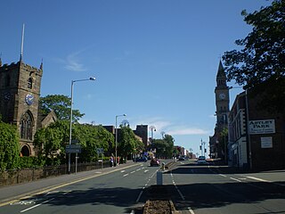
Longridge is a market town and civil parish in the borough of Ribble Valley in Lancashire, England. It is situated 8 miles (13 km) north-east of the city of Preston, at the western end of Longridge Fell, a long ridge above the River Ribble. The nearest villages are Grimsargh, 2 miles (3 km) to the southeast, and Ribchester 4 miles (6 km) to the southeast. The parish of Longridge had a population of 7,546 recorded in the 2001 census, increasing to 7,724 at the 2011 Census.

Ribble Valley is a local government district with borough status within the non-metropolitan county of Lancashire, England. The total population of the non-metropolitan district at the 2011 Census was 57,132. Its council is based in Clitheroe. Other places include Whalley, Longridge and Ribchester. The area is named after the River Ribble, which flows in its final stages towards its estuary near the Preston. The area is popular with tourists who enjoy the area's natural unspoilt beauty, much of which lies within the Forest of Bowland.
Padiham is a town and civil parish on the River Calder, about three miles (5 km) west of Burnley, Lancashire, England. It forms part of the Borough of Burnley. Originally by the River Calder, it is edged by the foothills of Pendle Hill to the north-west and north-east. The United Kingdom Census 2011 gave a parish population of 10,098, estimated in 2019 at 10,138.
Grimsargh is a village and civil parish in the City of Preston, Lancashire, England. located 5.7 miles (9 km) east of Preston.

Penwortham is a town in South Ribble, Lancashire, England, on the south bank of the River Ribble facing the city of Preston. The town is at the most westerly crossing point of the river, with major road and rail links crossing it here. The population of the town at the 2011 census was 23,047.
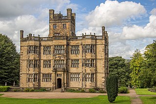
Gawthorpe Hall is an Elizabethan country house on the banks of the River Calder, in Ightenhill, a civil parish in the Borough of Burnley, Lancashire, England. Its estate extends into Padiham, with the Stockbridge Drive entrance situated there. The house is traditionally attributed to Robert Smythson. In the mid-19th century, the hall was rebuilt by Charles Barry, the architect of the Houses of Parliament. Since 1953 it has been designated a Grade I listed building. In 1970 the 4th Lord Shuttleworth gave the hall to the National Trust, with a 99-year lease to Lancashire County Council. Both bodies jointly administer the hall and in 2015 the council provided £500,000 funding for restoration work on the south and west sides of the house.

Chipping is a village and civil parish of the borough of Ribble Valley, Lancashire, England, within the Forest of Bowland Area of Outstanding Natural Beauty. In the 2001 census, the parish had a population of 1,046, falling slightly to 1,043 at the 2011 Census. This Lancashire village has won several best-kept village competitions over the years. The village also won the village section of the Royal Horticultural Society Britain in Bloom competition in 2009 picking up RHS Tourism and Gold achievement awards in the process.
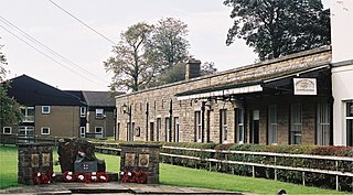
Longridge railway station was a passenger terminus of the Preston and Longridge Railway. It served the town of Longridge in Lancashire, England.
Whittingham is a civil parish in the City of Preston, Lancashire, England. The parish measures 4 miles (6 km) east-to-west, from the outskirts of Longridge to the outskirts of Broughton, but only 1 mile (1½ km) north-to-south. Its population was 2,189 in 2001, reducing to 2,027 at the time of the 2011 Census. The village of Goosnargh is at its centre.

Hurst Green is a small village in the Ribble Valley district of Lancashire, England, connected in its history to the Jesuit school, Stonyhurst College. The village is 5 miles (8 km) from Longridge and 4 miles (6 km) from Clitheroe, and is close to the River Ribble, near its junction with the River Hodder.

Ribbleton is a suburb and ward of the city of Preston, Lancashire, England. It is located to the east of the city centre, between the A59 New Hall Lane and the B6243 Longridge Road. The M6 motorway also runs through the area. The ward had a population of 7,351 recorded in the 2001 census increasing to 8,548 at the 2011 Census.

Hothersall is a civil parish in the Ribble Valley district, in Lancashire, England. The parish, which is on the north bank of the River Ribble, is rural and in the 2001 census had a population of 136, increasing to 145 at the 2011 Census. It is approximately 8 miles (13 km) north-east of Preston, and has boundaries with Longridge to the north and west, and Ribchester to the east.

Ashton Hall is a largely rebuilt 14th-century mansion in the civil parish of Thurnham, Lancashire, England. It is 3 miles (4.8 km) south of the city of Lancaster and is on the east bank of the River Lune. It is recorded in the National Heritage List for England as a Grade I listed building, and is now owned by Lancaster Golf Club.
Billinge Scar was a 19th-century country house near Blackburn, Lancashire, England.
Longridge is a civil parish in Ribble Valley, Lancashire, England. It contains 15 listed buildings that are recorded in the National Heritage List for England. Of these, one is at Grade II*, the middle grade, and the others are at Grade II, the lowest grade. The parish contains the town of Longridge and surrounding countryside. Most of the listed buildings are houses and farmhouses. The others include three churches, an inscribed stone, a tunnel portal, and a war memorial.
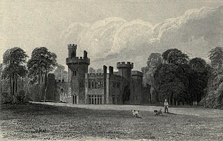
Childwall Hall was a 19th-century English country house located in Childwall, Liverpool, England. Built on the site of a previous mansion of the same name the Gothic Revival building was the seat of parliamentarian Bamber Gascoyne the Younger, a noted opponent of the abolition of slavery. The main building was demolished in 1949 and the current site is now occupied by television production company Lime Pictures. A lodge building and a few ruins of the same style are all that remain of the hall.


