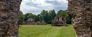
The abbey is a Grade I listed building and Scheduled Ancient Monument.[1][2] The ruins, which are now controlled by English Heritage, are open to the public. Although not an extensive ruin, there are boards on the site that give information regarding the history of the abbey and its former inhabitants.
In the mid-1140s, Swain, son of Swain, agreed to sell his lease on the site of the new abbey to Abbot Robert of Newminster, also adding a gift of land and wood at Swanside where a fountain (spring) dedicated to St Andrew is mentioned. Percy granted additional lands in the local area for the maintenance of the brethren at Dudland in Gisburn and Ellenthorpe in Paythorne, also confirming gifts from a tenant at Rimington and his steward at Ilkley. Shortly after he augmented this grant, adding Crooks House in Bracewell and Brogden and Stainton in Bank Newton.[4][5]
Percy had funded the construction of several wooden buildings, and Abbot Benedict along with twelve monks and ten conversi relocated from Newminster, with the abbey officially opening on 6 January 1147–8. Permission to build a fishpond and a mill were confirmed in 1154 by Roger de Pont L'Évêque, Archbishop of York and King Stephen. Pope Alexander III officially took the abbey under his protection in 1172.[3]
Around same time, Elias De Giggleswicke presented—along with his body for burial—the manors of Stainforth and Langcliffe to the Abbey. This included a corn mill at Langcliffe.[8]
In 1296, the move of the Cistercian monks from Stanlow Abbey to nearby Whalley caused consternation at Sawley. The monks here complained that they had both lost some of their income and that the cost of food and building materials had increased in the face of the extra demand. Even the hope that Whalley would develop a large tannery had caused the local sellers of tree bark to rise their prices to such an extent that Sawley's tanning operation was nearly destroyed. In 1305, at the general chapter of the Cistercian order, the dispute was settled with a command that Whalley should sell any excess produce to Sawley at market rates, and should either abbey's members transgress against the other, those people would be sent to the opposing abbey for punishment.[6] In September 1306, Archbishop William Greenfieldexcommunicated the abbot, John de Houeden, along with most of the senior monks and they were not absolved for seven years. The reason for this is no longer known. Around this time the Sawley community were further impoverished by attacks of Scots raiding parties, who looted and burnt some of their property, prompting Henry de Percy, 1st Baron Percy of Alnwick to give the church of St. Andrew at Gargrave in 1313.[3][7]
Despite being a relatively poor establishment, a scholarly tradition developed at the abbey. The abbot from 1224 to 1233, Stephen of Sawley, was a well respected spiritual writer, and William de Remmyngton went on to become Chancellor of the University of Oxford in 1372–3. An English translation of a Latin work by the 13th-century, scholar-bishop Robert Grosseteste is also thought to have originated here.[2]
Dissolution
With an annual revenue below £200 (the equivalent of £148,000 as of 2023[a]), Sawley was included in the initial group of monasteries ordered to be suppressed by King Henry VIII in 1536, during the dissolution of the monasteries. As a wave of uprisings spread across the country that would become known as the Pilgrimage of Grace, on 12 October, supported by the rebels, the monks returned to the empty abbey. They petitioned Sir Thomas Percy for aid, and received it from Sir Stephen Hamerton and Nicholas Tempest, who were able to persuade the Abbot of Whalley to support the cause. When news arrived that the Earl of Derby had been ordered to attack Sawley, the rebels were able to muster sufficient men to block the earl's advance from Preston at the end of the month. Robert Aske sent word of the results of his negotiation with the Duke of Norfolk at Doncaster and both sides disbanded without battle. The period of relative calm that followed was broken by Bigod's rebellion in January 1537, and it soon became clear that any hope of saving the abbey was lost. When the Duke of Norfolk arrived on 9 February, he found the abbey deserted. The monks had surrendered the building to Sir Richard Tempest, who then turned it over to Sir Arthur Darcy, who took the abbot prisoner.[9][10]
Although all agree that the last abbot was executed as punishment for his actions, there is disagreement as to both the place of execution and the identity of the office-holder. Thomas Bolton had been abbot for almost 10 years at the start of 1536. Many sources assert that Bolton was replaced by William Trafford just before the dissolution,[11][2] and some that Trafford was executed in Lancaster on 10 March 1537 alongside John Paslew, the last Abbot of Whalley.[6] It is possible that Bolton was executed and the addition of William Trafford to the list of abbots was an error made by John Stevens in the early 18th century and uncritically repeated by some authors ever since.[10] Sirs Thomas Percy and Stephen Hamerton, Nicholas Tempest, and Robert Aske were among those tried in London and sent to the gallows at Tyburn in late May and early June.[9]
Post-dissolution
A display of stones found around the site.A gateway reconstructed in 1962.
Arthur Darcy acquired the abbey and wrote to Thomas Cromwell about his search for one the abbey's chalices and financial records. By 1561 the abbey site was among the former monastic lands owned by Henry Darcy, the son of Sir Arthur Darcy.[11] Parts of the northern end of the west range may have been incorporated into a house which was still standing around 1850.[12] An isolated wall containing a fireplace, which survives to a height of 6 metres (20ft), could have been reused in the post-medieval building.[3] Elements of the abbey have been also incorporated into other buildings including carvings on the chancel screen at All Hallows Church, Great Mitton,[13] a two-storey bay window at Little Mearley Hall, Mearley,[14] along with decorated stonework at Middop Hall, Middop,[15] and at Southport Farmhouse, Sawley.[16]
Sawley manor had come into the possession of James Hay when he was created Lord Hay of Sawley in 1615, and it was inherited by his son. It passed through several generations of the Greville family, until in 1753, when Fulke Grenville sold Sawley to William Weddell of Newby Hall.[3] Upon his death in 1792 it passed to Weddell's distant cousin, Thomas de Grey, 2nd Earl de Grey who was still the site's owner in 1848. By this time much of the abbey's remains were hidden beneath mounds of rubbish and soil. Earl de Grey had much of the site cleared under the direction of John R Walbran, assisted by local unemployed men. They revealed the floor of the church and chapter house, uncovering six gravestones. The house must also have been demolished around this time,[b] and the wall that encloses the site today must have been constructed some time after.[5][3]
At the roadside 100 metres (330ft) north of the church is an archway containing a considerable quantity of decorated medieval stonework. It was reconstructed in 1962 from stone taken from a nearby demolished gateway, one of two constructed over the road around 1848 for Earl de Grey, using stones removed from the abbey site.[2][17]
Ownership followed the de Gray Earldom to George Robinson, 1st Marquess of Ripon, who was in possession by 1878. In 1934, the Sawley estate was purchased by John E Fattorini of Bradford for £81,285 (the equivalent of £7.29million as of 2023[a]).[3] In 1951 the area of the monastery passed into the guardianship of the Secretary of State.[2]
In March 2009, Sawley Abbey was featured in the first episode of series 3 of the TV series The Tudors.
Layout
The remains of monks' latrine.Much of the remains survive as low walls.
The core of the abbey consisted of a four-sided complex built around a courtyard measuring 37 by 28 metres (121 by 92ft), known as the cloister.[2] The entire abbey site was in an enclosed religious precinct covering 16.2 hectares (40 acres) and surrounded by a ditch and earthen bank, possibly topped with a stone wall. The entrances to the precinct seem to have been located near the south-east and north-west corners, where gatehouses were presumably located. The inner court appears to have been located on the south and east sides of the cloister, with the outer court on west and north sides.[3]
The church was aligned east–west and formed the northern range of the cloister. The transept is 38 by 12 metres (125 by 40ft) and both the north and south sides have three chapels along the eastern wall. On the northern side the is an exterior doorway and on the southern an entrance to the night stairs, which provided access from the monks' quarters. The original nave measured approximately 40 metres (130ft) in length and a narrow chapel was added along its north side in the 14th century. It was shortened around the turn of the 16th century to become a mere 9.1 by 12.2 metres (30 by 40ft), with the chancel lengthened and widened to 35 by 19 metres (116 by 62ft), at around the same time. The most visible remains today are the ruins of the church, which still retains walls standing up to 8 metres (26ft) high.[18][2]
The east range consisted of two floors with the monks' dorter (sleeping quarters) on the upper floor with an area of 313.6 square metres (3,376sqft). The ground floor contained a small sacristy, accessed from the church, for storage of sacred vessels, next to a library with access from the cloister. The chapter house extended beyond the range on the east, providing an undivided space measuring 14.78 by 7.05 metres (48.5ft ×23.1ft). The parlour was between the chapter house and the day stairs to the dormitory. At the close of the 12th century, this stairway was superseded by another in the south range and removed. The space modified to provide access from the parlour, possibly becoming a treasury or strong room. A transverse passageway separated the undercroft of the monks' dorter. Extending eastwards from the southern end of the range was a latrine block. At around the same time as the stairway modification, the south wall of the range was demolished, and building extended by 3.8 metres (12ft).[3]
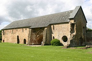
The calefactory (warming house), refectory and kitchen formed the south range. The warming house had a fireplace against the west wall and an external yard adjoining it to the south possibly used as a firewood store. Located next to the day stair, it may have had a second floor used to store muniments. The refectory was 9.3 by 30.8 metres (31 by 101ft), extending well south of the other buildings in the range. The kitchen was 12.25 by 8.80 metres (40.2 by 28.9ft) also with an external yard.[3]
The west range was originally housed the lay-brothers and included their sleeping quarters, dining hall and cellars, but was latterly partly converted into the abbot's lodgings. Abbey Cottage, adjoining the road on the western side of the site, is thought to contain walls that were originally part of the abbey's western range. A drain with some transverse arches and a piscina have been incorporated into its porch.[2][19]
Surrounding the abbey except on the west are many earthworks indicating the sites of structures such as the infirmary, infirmarer's house (keeper of the infirmary), bakery, and brewery along with other buildings, enclosures, gardens, stock pens, and watercourses. The abbey corn mill was located to the south-west of the abbey, near the River Ribble. The leat runs north–south along the base of the hill, cutting a bend in the river. The water supply was augmented via an additional channel from St Mary's Well situated to the north-east of the abbey.[2]
Books
A modern recreation of the Sawley Mappa Mundi. East is at the top, with perhaps a stylised Dome of the Rock denoting Jerusalem, just above centre right
Only three books thought to have been in the abbey's library are known to still exist, with two of those now at Cambridge University. Both manuscripts were acquired by Archbishop Matthew Parker and either gifted to the University Library in 1574, or bequeathed to Corpus Christi College after his death in 1575. The first is now in two parts, Cambridge University Library, Ff. i.27 and Cambridge, Corpus Christi College, MS 66. It contains the earliest known English example of a group of similar world maps that includes the Hereford Mappa Mundi. Traditionally known as the Henry of Mainz Map, it is thought to have been created in the late 12th or early 13th century, perhaps at Durham Priory. It is now known as the Sawley map. The second manuscript is Cambridge, Corpus Christi College, MS 139, thought to have been written around 1164.[20][21]
↑ A sizeable building is marked on the six inch Ordnance Survey map surveyed in 1847,[12] but is not mentioned by Harland in 1853.
Related Research Articles
Kirkstall Abbey is a ruined Cistercian monastery in Kirkstall, north-west of Leeds city centre in West Yorkshire, England. It is set in a public park on the north bank of the River Aire. It was founded c. 1152. It was disestablished during the Dissolution of the Monasteries under Henry VIII.
Fountains Abbey is one of the largest and best preserved ruined Cistercian monasteries in England. It is located approximately 3 miles (5 km) south-west of Ripon in North Yorkshire, near to the village of Aldfield. Founded in 1132, the abbey operated for 407 years, becoming one of the wealthiest monasteries in England until its dissolution, by order of Henry VIII, in 1539.
Basingwerk Abbey is a Grade I listed ruined abbey near Holywell, Flintshire, Wales. The abbey, which was founded in the 12th century, belonged to the Order of Cistercians. It maintained significant lands in the English county of Derbyshire. The abbey was abandoned and its assets sold following the Dissolution of the Monasteries in 1536.
Roche Abbey is a now-ruined abbey in the civil parish of Maltby, Rotherham, South Yorkshire, England. It is in the valley of Maltby Dyke, known locally as Maltby Beck, and is administered by English Heritage. It is a scheduled monument and Grade II* listed in the National Register of Historic Parks and Gardens.
Netley Abbey is a ruined late medieval monastery in the village of Netley near Southampton in Hampshire, England. The abbey was founded in 1239 as a house for monks of the austere Cistercian order. Despite royal patronage, Netley was never rich, produced no influential scholars nor churchmen, and its nearly 300-year history was quiet. The monks were best known to their neighbours for the generous hospitality they offered to travellers on land and sea.
The Pilgrimage of Grace was a popular revolt beginning in Yorkshire in October 1536, before spreading to other parts of Northern England including Cumberland, Northumberland, Durham and north Lancashire, under the leadership of Robert Aske. The "most serious of all Tudor period rebellions", it was a protest against Henry VIII's break with the Catholic Church, the dissolution of the lesser monasteries, and the policies of the King's chief minister, Thomas Cromwell, as well as other specific political, social, and economic grievances.
Waverley Abbey was the first Cistercian abbey in England, founded in 1128 by William Giffard, the Bishop of Winchester.
Vaudey Abbey, also known as Vandy Abbey or Vandey Abbey, was an English Cistercian abbey. It was founded in 1147 by William, Count of Aumale, Earl of York. Its site is within the Grimsthorpe Castle park, in Lincolnshire, 3.7 miles (6 km) northwest of Bourne on the A151, but there are no remains of the Abbey aside from earthworks.
Newminster Abbey was a Cistercian abbey in Northumberland in the north of England. The site is protected by Grade II listed building and Scheduled Ancient Monument status.
Cleeve Abbey is a medieval monastery located near the Washford River and village of Washford, in the English county of Somerset. It is a Grade I listed building and has been scheduled as an ancient monument.
Robert of Newminster was a priest, abbot, and a saint of the Catholic Church. He was born in Gargrave in Yorkshire, England. He was one of the monks who founded Fountains Abbey and is named from the abbey he founded in Morpeth, Northumberland.
Whalley Abbey is a former Cistercian abbey in Whalley, Lancashire, England. After the dissolution of the monasteries, the abbey was largely demolished and a country house was built on the site. In the 20th century the house was modified and it is now the Retreat and Conference House of the Diocese of Blackburn of the Church of England. The ruins of the abbey are recorded in the National Heritage List for England as a designated Grade I listed building, and are a Scheduled Ancient Monument.
Gisburn is a village and civil parish within the Ribble Valley borough of Lancashire, England. Historically within the West Riding of Yorkshire, it lies 8 miles (13 km) northeast of Clitheroe and 11 miles (18 km) west of Skipton. The civil parish had a population of 506, recorded in the 2001 census, increasing to 521 at the 2011 Census.
Sawley is a village and civil parish in the Borough of Ribble Valley in Lancashire, England. The population of the civil parish was 305 at the 2001 Census, rising to 345 at the 2011 census. It is situated north-east of Clitheroe, on the River Ribble. It was historically part of the West Riding of Yorkshire.
Paythorne is a small village and civil parish in Ribble Valley, Lancashire, England. It is situated alongside the River Ribble, north-east of Clitheroe, and on the boundary with North Yorkshire. Other parishes adjacent to Paythorne are Halton West, Nappa, Newsholme, Horton, Gisburn, Sawley, Bolton-by-Bowland and Gisburn Forest. The nearest town is Barnoldswick, situated 7 kilometres (4.3 mi) south-east of the village. Paythorne is on the edge of the Forest of Bowland Area of Outstanding Natural Beauty, although only a small area in the west of the parish is within the area's boundary. The Ribble Way long-distance walk passes through the village.
Easington is a civil parish within the Ribble Valley district of Lancashire, England, with a population in 2001 of 52. The Census 2011 population details have been grouped with the parish of Slaidburn. Before 1974, it formed part of Bowland Rural District in the West Riding of Yorkshire. It covers just over 9000 acres.
Gisburn Forest is a civil parish in the Ribble Valley, in Lancashire, England. Mainly lying within the Forest of Bowland Area of Outstanding Natural Beauty, the parish includes the larger part of the village of Tosside and the hamlet of Grunsagill to the south. Historically, the parish lay within the West Riding of Yorkshire. It had a population of 151 at the 2011 Census.
The Abbey of Saint Mary de Pratis, more commonly known as Leicester Abbey, was an Augustinian religious house in the city of Leicester, in the East Midlands of England. The abbey was founded in the 12th century by the Robert de Beaumont, 2nd Earl of Leicester, and grew to become the wealthiest religious establishment within Leicestershire. Through patronage and donations the abbey gained the advowsons of countless churches throughout England, and acquired a considerable amount of land, and several manorial lordships. Leicester Abbey also maintained a cell at Cockerham Priory, in Lancashire. The Abbey's prosperity was boosted through the passage of special privileges by both the English Kings and the Pope. These included an exemption from sending representatives to parliament and from paying tithe on certain land and livestock. Despite its privileges and sizeable landed estates, from the late 14th century the abbey began to suffer financially and was forced to lease out its estates. The worsening financial situation was exacerbated throughout the 15th century and early 16th century by a series of incompetent, corrupt and extravagant abbots. By 1535 the abbey's considerable income was exceeded by even more considerable debts.
Stephen of Sawley, also known as Stephen of Easton, was a Cistercian monk, born in Eston, Yorkshire in the late twelfth century.
1 2 3 4 5 6 7 8 9 10 Glyn Coppack; Colin Hayfield; Rich Williams (2002). "Sawley Abbey: The Architecture and Archaeology of a Smaller Cistercian Abbey". Journal of the British Archaeological Association. 155: 22–114. doi:10.1179/jba.2002.155.1.22. S2CID191609293.
↑ Charles Travis Clay; William Farrer, eds. (2013). Early Yorkshire Charters: Volume 11, The Percy Fee. Cambridge University Press. pp.26–28.
↑ Dumville, David (1980). "The sixteenth-century history of two Cambridge books from Sawley". Transactions of the Cambridge Bibliographical Society. 7 (4): 427–444. JSTOR41154587.
This page is based on this Wikipedia article Text is available under the CC BY-SA 4.0 license; additional terms may apply. Images, videos and audio are available under their respective licenses.