
Northampton is a town and civil parish in the West Northamptonshire unitary authority area of Northamptonshire, England. It is the county town of Northamptonshire and the administrative centre of the unitary authority of West Northamptonshire. The town is situated on the River Nene, 60 miles (97 km) north-west of London and 50 miles (80 km) south-east of Birmingham. Northampton is one of the largest towns in England; the population of its overall urban area was recorded as 249,093 in the 2021 census. The parish of Northampton alone had 137,387.
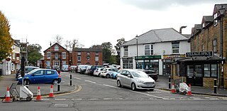
Long Buckby is a large village and civil parish in West Northamptonshire, England. In the 2021 census the parish of Long Buckby, which includes the hamlet of Long Buckby Wharf, was recorded as having a population of 4,511.
Earl Spencer is a title in the Peerage of Great Britain that was created on 1 November 1765, along with the title Viscount Althorp, of Althorp in the County of Northampton, for John Spencer, 1st Viscount Spencer. He was a member of the prominent Spencer family and a great-grandson of the 1st Duke of Marlborough. Previously, he had been created Viscount Spencer, of Althorp in the County of Northampton, and Baron Spencer of Althorp, of Althorp in the County of Northampton, on 3 April 1761.

Kettering is a market and industrial town as well as a civil parish in the North Northamptonshire district, in the ceremonial county of Northamptonshire, England. It is 45 miles (72 km) west of Cambridge, 31 miles (50 km) southwest of Peterborough, 28 miles (45 km) southeast of Leicester and 15 miles (24 km) north-east of Northampton. It is west of the River Ise, a tributary of the River Nene. The name means "the place of Ketter's people ".
Thornby is a village and civil parish in West Northamptonshire in England. It has a Manor house. At the time of the 2001 census, the parish's population was 162 people, increasing to 189 at the 2011 Census. The village is bisected by the A5199 road between Northampton and Leicester and about 11 miles (17.7 km) north-west of Northampton town centre. It is about 1½ miles south of a junction with the A14 road which joins the M1 Motorway and M6 junction at Catthorpe with Felixstowe, Suffolk.
Ravensthorpe is a village and civil parish in West Northamptonshire in England. The village lies approximately midway between Northampton and Rugby. The M1 motorway is six miles west and the nearest railway station is at Long Buckby. At the time of the 2001 census, the parish's population was 656 people, including Coton but falling slightly to 646 at the 2011 census.
Harlestone is a village and civil parish in the West Northamptonshire district, in the ceremonial county of Northamptonshire, England. The parish had a recorded population of 445 in the 2011 census. From 1974 to 2021 it was in Daventry district.

East Haddon is a village and civil parish in West Northamptonshire, England. The village is located approximately midway between the towns of Northampton and Daventry, with each town being around 8 miles to the east and west of the village respectively. East Haddon is close to Althorp, the stately home and estate of the Spencer family, and surrounded by the villages of Ravensthorpe to the north, Holdenby to the east, Great Brington to the south, and Long Buckby to the west.

Dodford is a village in West Northamptonshire, England. Prior to local government changes in 2021 it was within the Weedon Ward of Daventry District. The village is just north of the A45 road 1+1⁄2 miles (2.4 km) west of Weedon. The population of the civil parish at the 2011 Census was 203. It is 3+1⁄2 miles (5.6 km) east of Daventry and 10 miles (16 km) west of Northampton. It is also close to junction 16 of the M1 motorway. The parish consists of some 1,384 acres (560 ha) and is bounded on the east by the A5 trunk road which is the old Roman road of Watling Street. Most of the village and parish sits astride the valley of an east-flowing stream which is a tributary of the River Nene.

Creaton is a village and civil parish in West Northamptonshire, England.

Charwelton is a village and civil parish about 5 miles (8 km) south of Daventry in Northamptonshire, England. The 2011 Census recorded the parish's population as 220.

Sulgrave is a village and civil parish in West Northamptonshire, England, about 5 miles (8 km) north of Brackley. The village is just south of a stream that rises in the parish and flows east to join the River Tove, a tributary of the Great Ouse.

Upton is a civil parish north-east of Kislingbury and south-west of Dallington, in Northamptonshire, England about 3.5 miles (6 km) west of Northampton town centre along the A4500 road. Formerly a scattered hamlet, it is now part of the town. The area west of Northampton is now a major area of expansion of the town and named Upton after the parish.
Hardingstone is a village in Northamptonshire, England. It is on the southern edge of Northampton, and now forms a suburb of the town. It is about 1 mile (2 km) from the town centre. The Newport Pagnell road separates the village from the nearby village of Wootton, which has also been absorbed into the urban area.

Gayton is a rural village and civil parish in West Northamptonshire, England, 5 miles (8 km) south-west of Northampton town centre. The village is situated on a hill close to the larger villages of Bugbrooke, Milton Malsor and Blisworth, with a linked public footpath network. At the 2011 Census, the population of the parish was 544.

West Northamptonshire is a unitary authority area in the ceremonial county of Northamptonshire, England, and was created in 2021. It contains the county town of Northampton, as well as the towns of Daventry, Brackley and Towcester, and the large villages of Brixworth and Long Buckby; the rest of the area is predominantly agricultural villages though it has many lakes and small woodlands.
Dingley is a village and civil parish in Northamptonshire, England, located along the A427, about 2 miles (3.2 km) east of the nearest town, Market Harborough. It is also close to the A6 and near the border with Leicestershire. At the time of the 2001 census, the parish's population was 209 people, reducing to 194 at the 2011 census.

The lost village of Canons Ashby is located in ground to the north of Canons Ashby House in the English county of Northamptonshire. Today there is still a small village around the house but this is located away from the original settlement, since the original settlement is now just field occupied by a herd of cows.
Ascebi is the name of the medieval village that is the lost settlement, Canons Ashby itself is currently not lost at all and people can easily find it on any map.
The lost village of Church Charwelton lies south-east of the village of Charwelton in the English county of Northamptonshire. Its site is on the north-east bank of the River Cherwell. The Jurassic Way long-distance footpath passes across the site.


