Nathaniel Jeremiah Bradlee was a Boston architect and a partner in the firm of Bradlee, Winslow & Wetherell.

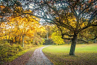
Franklin Park, a partially wooded 527-acre (2.13 km2) parkland in the Jamaica Plain, Roxbury, and Dorchester neighborhoods of Boston, Massachusetts, is maintained by the City of Boston Parks and Recreation Department. It is Boston's biggest park and the site of Franklin Park Zoo. It was designated a Boston Landmark by the Boston Landmarks Commission in August 1980.

St. Joseph Catholic Church was a parish in the Roman Catholic Archdiocese of Boston, serving the Roxbury neighborhood of Boston, Massachusetts, USA. The parish was established in 1845, and a church was built in the same year. The entire church complex, including the rectory, convent and parish school, was added to the National Register of Historic Places in 1989. The parish was closed by the archdiocese in 2002, after which the property was sold.

The Shirley–Eustis House is a historic house located at 33 Shirley Street, Boston, Massachusetts. It is a U.S. National Historic Landmark.

The Winthrop Building is an historic skyscraper at 7 Water Street in Boston, Massachusetts.

Eliot Burying Ground is a historic seventeenth-century graveyard at Eustis and Washington Streets in the Roxbury neighborhood of Boston, Massachusetts. It occupies a roughly triangular lot of 0.8 acres (0.32 ha).

The Boylston Building is an historic building at 2–22 Boylston Street in Boston, Massachusetts. The six-story sandstone building was designed by Carl Fehmer and built in 1887 by Woodbury & Leighton. It is an early instance in Boston of a skeleton-built commercial structure, rather than having load-bearing masonry walls. The building housed the Boylston Market, a wholesale trading exchange which had been on the site since 1810.

The Dimock Community Health Center Complex is a historic medical complex at 41 and 55 Dimock Street in Boston, Massachusetts.

John Eliot Square District is a historic district located in the northern Roxbury neighborhood of Boston, Massachusetts. It is formed by the intersection of Dudley, Bartlett, Centre, Roxbury and Highland Streets. Named after local missionary to the Indians, John Eliot, the square was the site of the Roxbury town center after its founding in 1630. Roxbury was annexed to Boston in 1868, and John Eliot Square was added to the National Register of Historic Places in 1973. The square is the nucleus of Roxbury Heritage State Park, a history-themed heritage park.

The Harrison Loring House is a historic house at 789 East Broadway in the South Boston neighborhood of Boston, Massachusetts. It is a 2+1⁄2-story brick mansion, with a mansard roof in the Second Empire style. It has brownstone trim around the windows, a modillioned cornice, and a projecting center section with its entrance sheltered by a shallow portico. It was built in 1865 for Harrison Loring, owner of the City Point Iron Works, a major South Boston shipyard, at which steamships were built in the late 19th century. Loring lived in this house until 1894.

The Moreland Street Historic District is a historic district roughly bounded by Kearsarge, Blue Hill Avenues, and Warren, Waverly, and Winthrop Streets in the Roxbury neighborhood of Boston, Massachusetts. It encompasses 63 acres (25 ha) of predominantly residential urban streetscape, which was developed between about 1840 and 1920. Housing types represent a cross-section of architectural styles from the period, including Second Empire, Italianate, and Queen Anne style. It is a fairly well-preserved grouping in an area where many sections have been negatively affected by urban blight and redevelopment. One notable house is at 130 Warren Street: it is the only house in the district built out of Roxbury puddingstone. That building is currently under study as a pending landmark for the Boston Landmarks Commission.

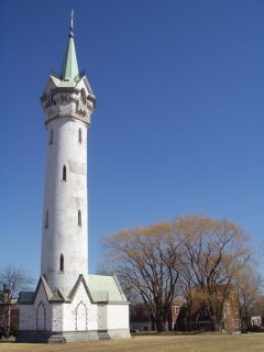
Roxbury High Fort is a historic fort site on Beech Glen Street at Fort Avenue in the Roxbury neighborhood of Boston, Massachusetts. The site now contains a small park and the Cochituate Standpipe, also known as Fort Hill Tower, built in 1869. The fort site was added to the National Register of Historic Places in 1973. The site inspired the name of the Fort Hill neighborhood, which surrounds the area of the High Fort.

The Second Brazer Building is an historic office building at 25-29 State Street in Boston, Massachusetts, with a locally significant early Beaux Arts design.

Abbotsford, now the Museum of the National Center of Afro-American Artists, is a historic house at 300 Walnut Avenue in Boston, Massachusetts, USA. The museum is dedicated to black visual arts heritage worldwide, and presents historical and contemporary exhibitions in many media, including painting, sculpture, graphics, photography and decorative arts. The museum is operated by the National Center of Afro-American Artists.

Brookline Village is one of the major commercial and retail centers of the town of Brookline, Massachusetts. Located just north of Massachusetts Route 9 and west of the Muddy River, it is the historic center of the town and includes its major civic buildings, including town hall and the public library. The commercial spine of the village, extending along Washington Street from Route 9 to the library, is a historic district listed on the National Register of Historic Places as the Brookline Village Commercial District.

West Roxbury Parkway is a historic parkway running from Washington Street in Boston, Massachusetts, where the Enneking Parkway runs south, to Horace James Circle in Brookline, where it meets the Hammond Pond Parkway. The parkway serves as a connector between Stony Brook Reservation and Hammond Pond Reservation. West Roxbury Parkway was built between 1919 and 1929 and added to the National Register of Historic Places in 2006. The parkway is distinctive in the roadway system developed by the Metropolitan District Commission beginning around the turn of the 20th century in that it was built in collaboration with the City of Boston, and is maintained by the city.

Roxbury Heritage State Park is a history-themed heritage park in the oldest part of Roxbury, a former town annexed in 1868 by Boston, Massachusetts. It is anchored by the Dillaway–Thomas House, a large colonial structure built in 1750 and thought to be the oldest surviving house in Roxbury. The location includes an adjacent 1-acre (0.40 ha) landscaped park with views of the Boston skyline, and is part of the Metropolitan Park System of Greater Boston.

Fort Hill is a 0.4 square mile neighborhood and historic district of Roxbury, in Boston, Massachusetts. The approximate boundaries of Fort Hill are Malcolm X Boulevard on the north, Washington Street on the southeast, and Columbus Avenue on the southwest.
A Boston Landmark is a designation by the Boston Landmarks Commission for historic buildings and sites throughout the city of Boston based on the grounds that it has historical, social, cultural, architectural or aesthetic significance to New England or the United States. While National Landmark or National Register status can provide tax incentives for the owner of an income-producing property, local landmark status provides more control over modifications to a designated historic structure or place.


